Items Similar to Denbighshire & Flintshire – Antique Map from Drayton’s Poly-Olbion, 1622
Video Loading
Want more images or videos?
Request additional images or videos from the seller
1 of 11
Denbighshire & Flintshire – Antique Map from Drayton’s Poly-Olbion, 1622
$737.27
$921.5920% Off
£543.85
£679.8120% Off
€616
€77020% Off
CA$1,021.53
CA$1,276.9120% Off
A$1,109.18
A$1,386.4720% Off
CHF 587.39
CHF 734.2420% Off
MX$13,595.35
MX$16,994.1920% Off
NOK 7,269.20
NOK 9,086.5020% Off
SEK 6,869.01
SEK 8,586.2620% Off
DKK 4,689.52
DKK 5,861.9020% Off
About the Item
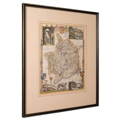
Denbighshire & Flintshire – Antique Map from Drayton’s Poly-Olbion, 1622
This rare and original antique map of Denbighshire and Flintshire in Wales originates from the celebrated Poly-Olbion, an extraordinary topographical poem and atlas composed by the English poet Michael Drayton, first published in 1622. Uniquely blending literature and cartography, Poly-Olbion aimed to describe every region of England and Wales in both poetic and visual form, resulting in one of the most distinctive and artistic mapping projects of the 17th century.
The map shows the two adjacent Welsh counties—Denbighshire and Flintshire—with stylized representations of hills, rivers, forests, and towns. Allegorical figures and natural features such as nymphs, shepherds, and river deities are illustrated across the landscape in imaginative poses, reflecting the poetic tone of Drayton's verses. Each map in the series was engraved by William Hole, who brought a unique artistic sensibility to the depiction of regional identity.
Of particular note is the whimsical aesthetic of the rivers and mountain ranges, which are personified or illustrated with poetic license rather than geographical precision. This creative cartographic approach makes the Poly-Olbion maps as much works of art and literature as they are tools for geographic understanding.
These maps are highly sought-after by collectors for their historical significance, rarity, and the fact that they bridge the worlds of poetry, art, and geography—an ambitious vision of national identity through landscape and myth.
Condition report: Fine impression with strong plate marks. Some minor age-related toning and faint spots in margins; no tears or repairs. Paper remains strong and well-preserved.
Framing tips: A dark wood frame (such as oak or walnut) paired with a deep cream or warm grey mat will enhance the antique tones and complement the engraved lines. Consider a double mat with a thin inner line in green or terracotta to reflect the Welsh landscape.
- Dimensions:Height: 10.36 in (26.3 cm)Width: 13.51 in (34.3 cm)Depth: 0.02 in (0.5 mm)
- Materials and Techniques:Paper,Engraved
- Period:Mid-17th Century
- Date of Manufacture:1622
- Condition:Fine impression with strong plate marks. Some minor age-related toning and faint spots in margins; no tears or repairs. Paper remains strong and well-preserved.
- Seller Location:Langweer, NL
- Reference Number:Seller: BG-13324-11stDibs: LU3054333591742
About the Seller
5.0
Recognized Seller
These prestigious sellers are industry leaders and represent the highest echelon for item quality and design.
Platinum Seller
Premium sellers with a 4.7+ rating and 24-hour response times
Established in 2009
1stDibs seller since 2017
2,622 sales on 1stDibs
Typical response time: <1 hour
- ShippingRetrieving quote...Shipping from: Langweer, Netherlands
- Return Policy
Authenticity Guarantee
In the unlikely event there’s an issue with an item’s authenticity, contact us within 1 year for a full refund. DetailsMoney-Back Guarantee
If your item is not as described, is damaged in transit, or does not arrive, contact us within 7 days for a full refund. Details24-Hour Cancellation
You have a 24-hour grace period in which to reconsider your purchase, with no questions asked.Vetted Professional Sellers
Our world-class sellers must adhere to strict standards for service and quality, maintaining the integrity of our listings.Price-Match Guarantee
If you find that a seller listed the same item for a lower price elsewhere, we’ll match it.Trusted Global Delivery
Our best-in-class carrier network provides specialized shipping options worldwide, including custom delivery.More From This Seller
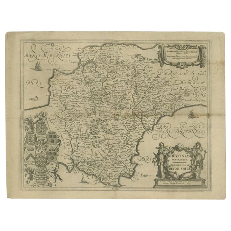
View AllAntique Map of the County of Devon by Overton, 1713
Located in Langweer, NL
Antique map titled 'Devoniae Descriptio - The Description of Devon Shire'. Map of the County of Devon, England. This map originates from the 1713 edition of the 'Overton Atlas'. Henry Overton only revised the Devon map...
Category
Antique 18th Century Maps
Materials
Paper
$276 Sale Price
20% Off
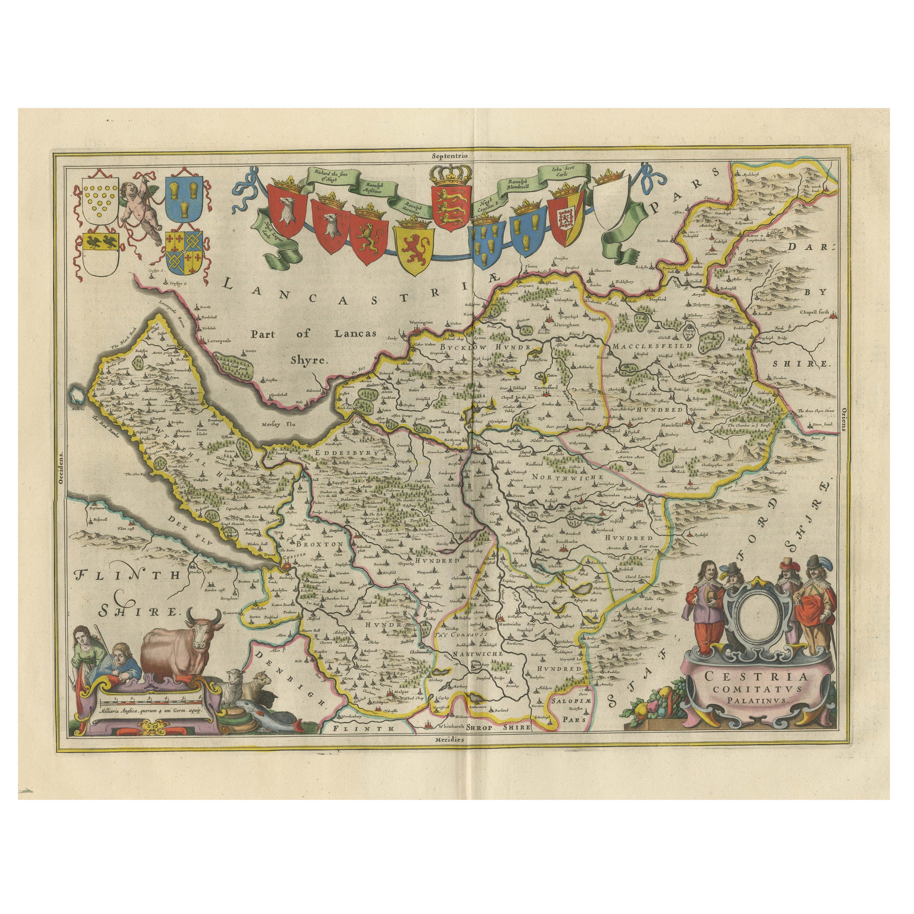
Antique Map of Cheshire, North West England
By Joan (Johannes) Blaeu
Located in Langweer, NL
Antique map titled 'Cestria comitatus Palatinus'. Original old map of Cheshire, Northwest England. Published circa 1665 by J. Blaeu. Willem Jansz. Blaeu and his son Joan Blaeu are th...
Category
Antique Mid-17th Century Maps
Materials
Paper
$1,148 Sale Price
20% Off
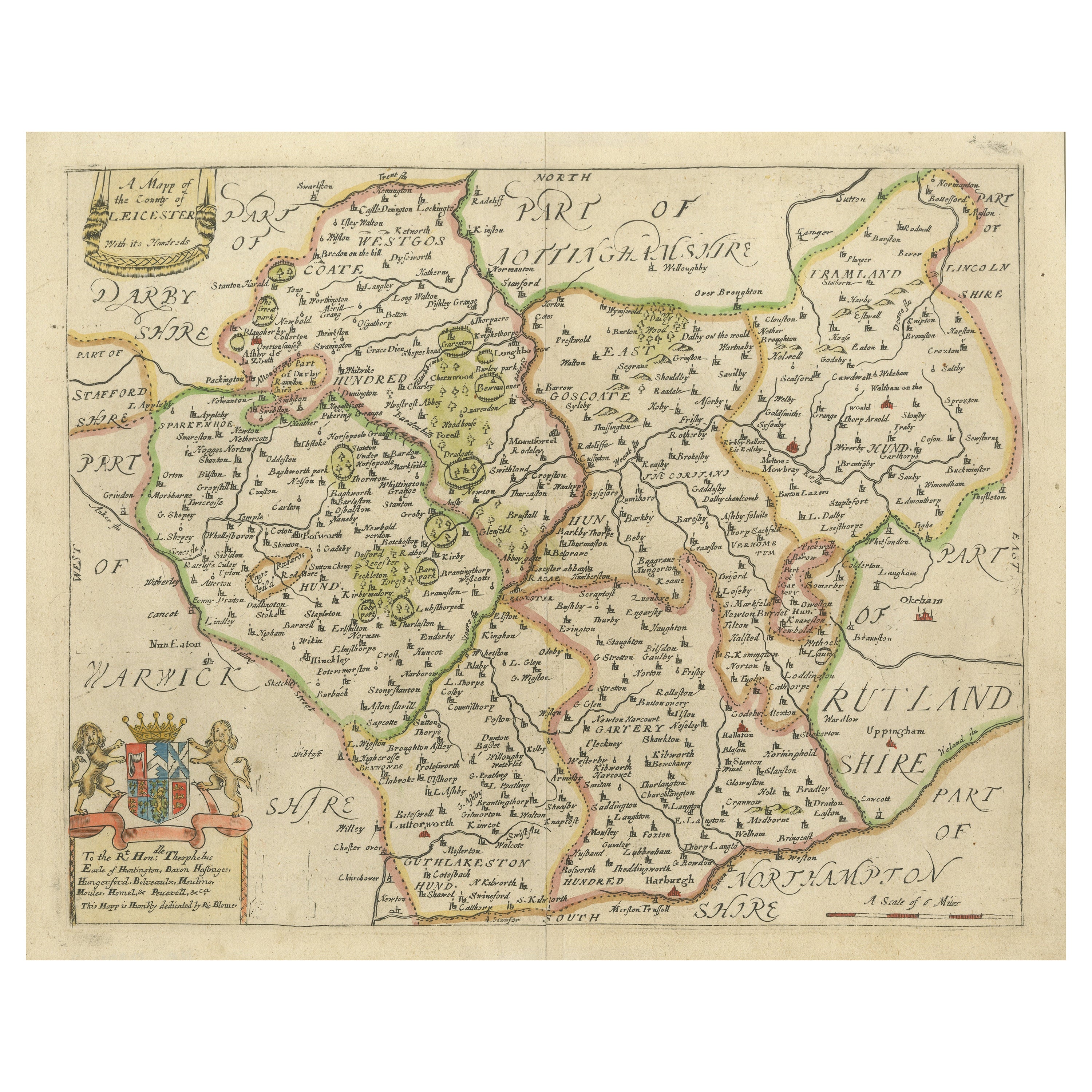
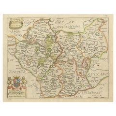
Leicestershire – Antique Map of Leicester by Richard Blome, Britannia 1673
Located in Langweer, NL
Leicestershire – Antique Map of Leicester by Richard Blome, Britannia 1673
This original antique map titled A Mapp of the Country of Leicester presents a detailed and decorative dep...
Category
Antique Late 17th Century English Maps
Materials
Paper
$421 Sale Price
20% Off
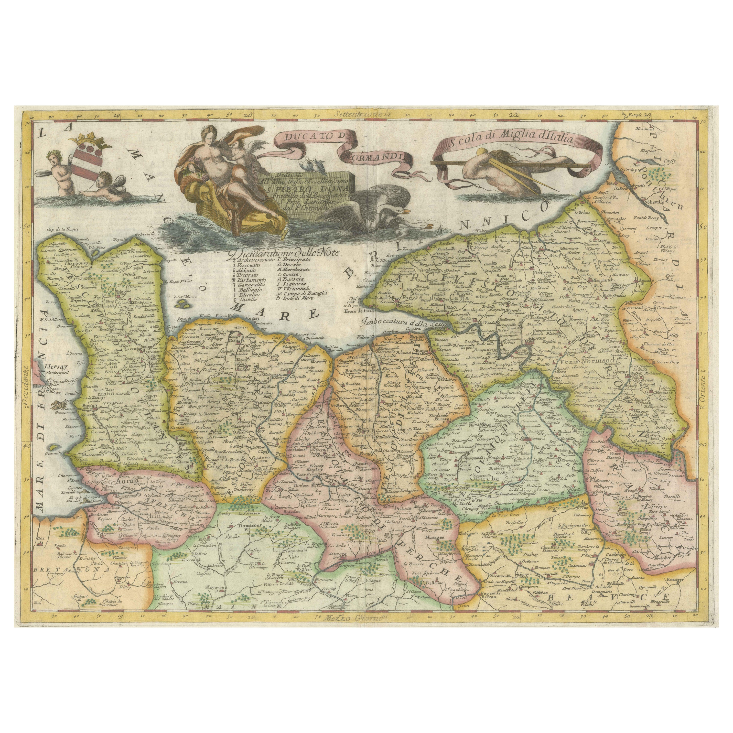
Decorative Original Antique Map of Normandy, France, circa 1690
Located in Langweer, NL
Original antique map titled 'Ducato D'Normandie Scala di Miglia d'Italia'. Very decorative map of Normandy, with a fine title cartouche featuring Leda ...
Category
Antique Late 17th Century Italian Maps
Materials
Paper

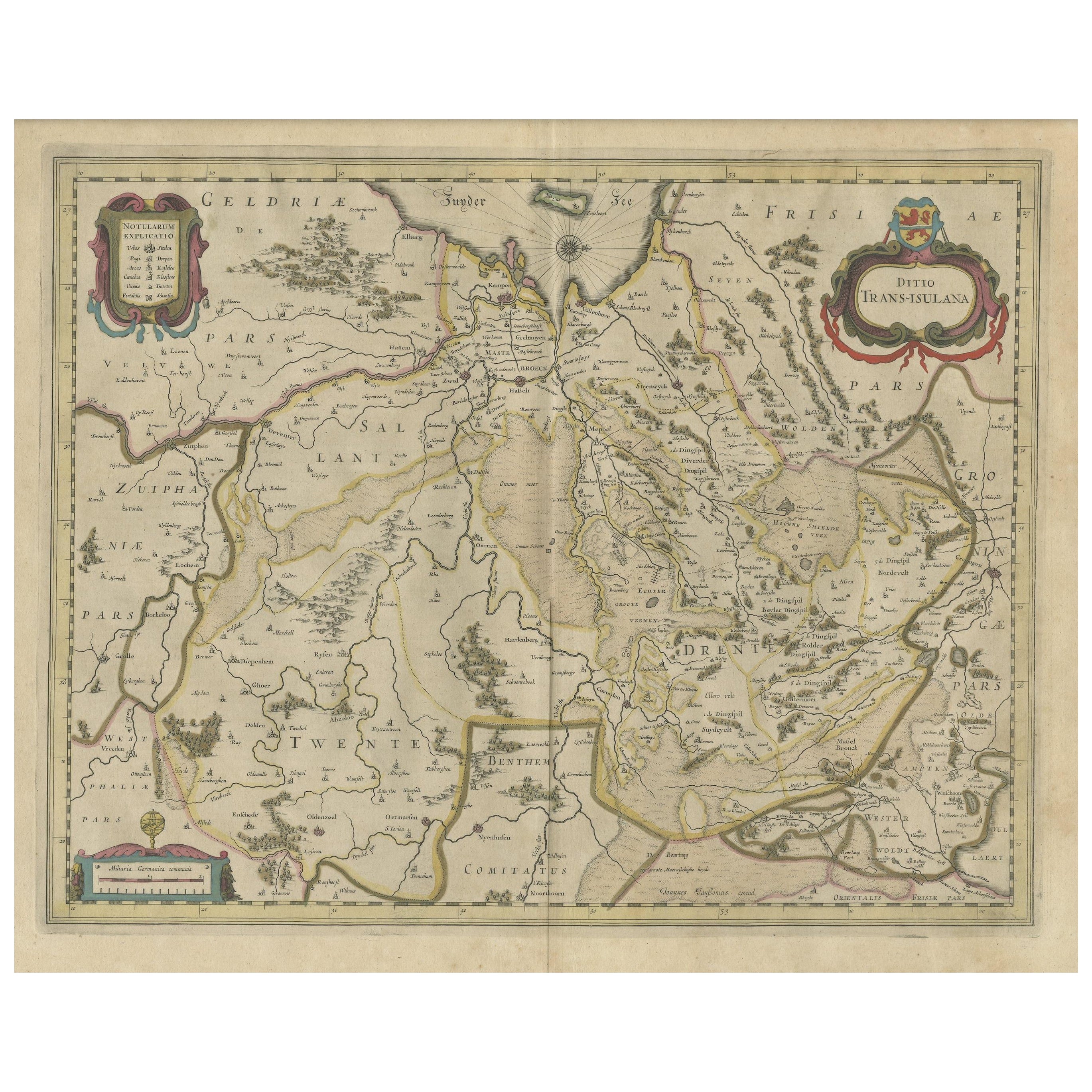
Antique Map of the Province of Overijssel, the Netherlands
Located in Langweer, NL
Original antique map titled 'Ditio Trans-Isulana'. Original old map of the province of Overijssel, the Netherlands. With coat of arms and two decorative cartouches. Published by J. J...
Category
Antique Mid-17th Century Maps
Materials
Paper
$469 Sale Price
20% Off
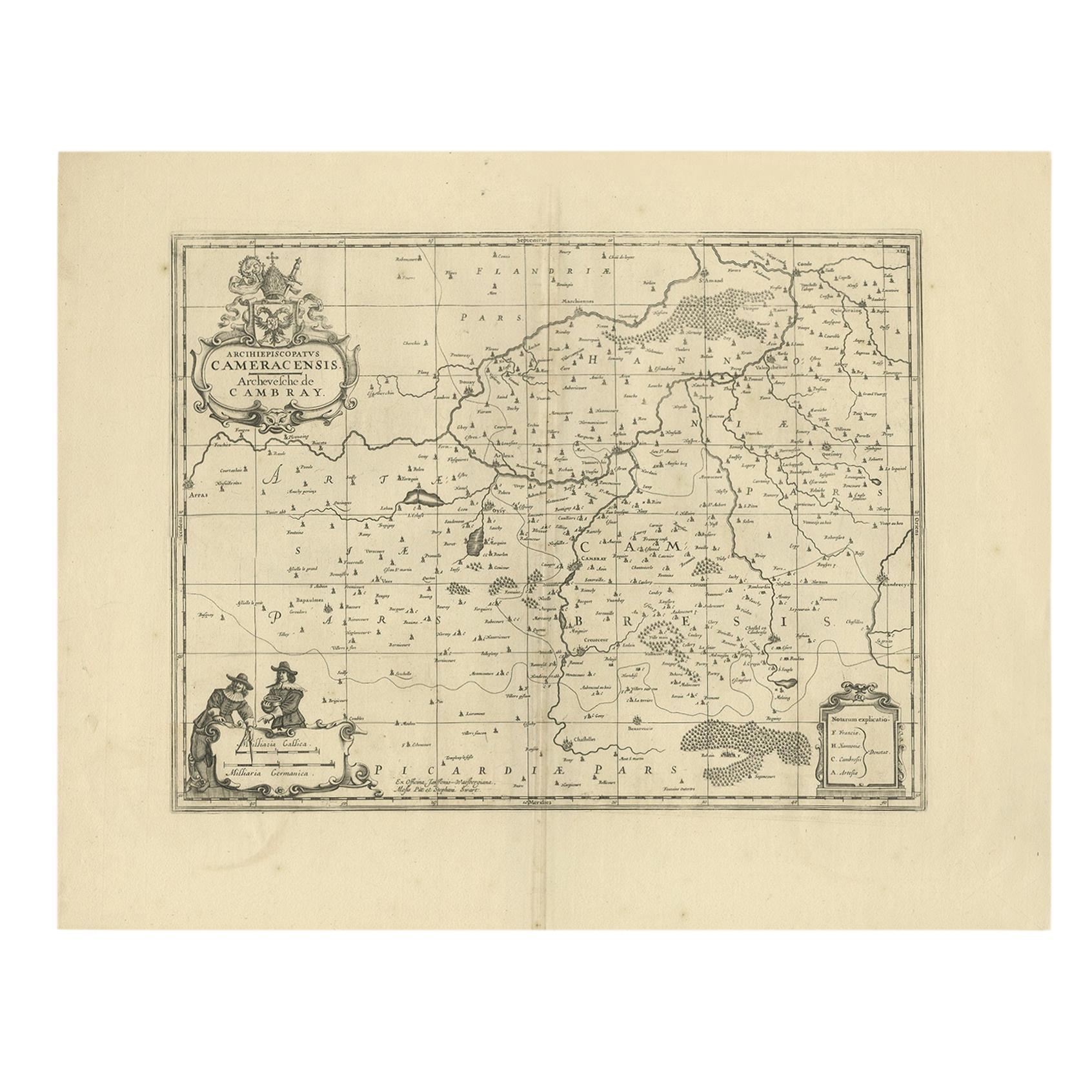
Antique Map of the Cambrai Region by Pitt, circa 1680
Located in Langweer, NL
Antique map titled 'Archiepiscopatus Cameracensis - Archevesche de Cambray'. Decorative map of the Cambrai region of France. This map originates from 'The English Atlas' by Moses Pit...
Category
Antique Late 17th Century Maps
Materials
Paper

$574 Sale Price
20% Off
You May Also Like
1752 Vaugoundy Map of Flanders : Belgium, France, and the Netherlands, Ric.a002
Located in Norton, MA
Large Vaugoundy Map of Flanders:
Belgium, France, and the Netherlands
Colored -1752
Ric.a002
Description: This is a 1752 Didier Robert de Vaugondy map of Flanders. The map de...
Category
Antique 17th Century Unknown Maps
Materials
Paper

1657 Janssonius Map of Vermandois and Cappelle, Ric. A-004
Located in Norton, MA
1657 Janssonius map of
Vermandois and Cappelle
Ric.a004
Description: Antique map of France titled 'Descriptio Veromanduorum - Gouvernement de la Cappelle'. Two detailed maps o...
Category
Antique 17th Century Unknown Maps
Materials
Paper

Antique Lithography Map, Monmouthshire, Framed, Welsh Cartography, Victorian
Located in Hele, Devon, GB
This is an antique lithography map of Monmouthshire. An English, framed atlas engraving of cartographic interest, dating to the mid 19th century and later.
Superb lithography of Mo...
Category
Antique Mid-19th Century British Victorian Maps
Materials
Glass, Wood, Paper
Original Antique English County Map - Monmouthshire. J & C Walker. 1851
Located in St Annes, Lancashire
Great map of Monmouthshire
Original colour
By J & C Walker
Published by Longman, Rees, Orme, Brown & Co. 1851
Unframed.
Category
Antique 1850s English Other Maps
Materials
Paper

17th Century John Speed Map of Denbighshire, c.1610
By John Speed
Located in Royal Tunbridge Wells, Kent
Antique early 17th century British very rare and original John Speed, hand coloured map of Denbighshire, dated 1610, by John Sunbury and George Humble. John...
Category
Antique 17th Century British Maps
Materials
Wood, Paper

1633 Map "La Souverainete De Sedan Et De Raucourt, Et La Prevoste Ric0011
Located in Norton, MA
1653 map entitled
"La Souverainete de Sedan et de Raucourt, et la Prevoste de Doncheri,"
Ric0011
Description:
Lovely map centered on Sedan and Doncheri and the Meuze River fr...
Category
Antique 17th Century Dutch Maps
Materials
Paper

More Ways To Browse
Washington Dc Map
Wood Carved Golfer
1681 Moses Pitt
Antique Map Bermuda
Antique Map Of Brooklyn
Antique Map Of Republic Of Texas
Extra Large Map
George Weymouth
Georgetown Map
Hemisphere Antiques
J Matthews
Japanese Kite
Maltese Falcon
Map Tuscany
St Eustatius
Sumba Map
Used Furniture Denver Co
Used Furniture Leominster