Items Similar to Map of the Shire of Westergo in the Province of Friesland, the Netherlands, 1664


Want more images or videos?
Request additional images or videos from the seller
1 of 6
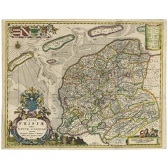
Map of the Shire of Westergo in the Province of Friesland, the Netherlands, 1664
About the Item
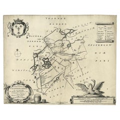
Antique map titled 'Westergoa Olim Westrachia.'
Map of the shire of Westergo in the province of Friesland in the Netherlands, including Stavoren, Bolsward, Franeker, Sneek, Leeuwarden and other cities. Multiple cartouches, key and coat of arms. This map originates from 'Beschrijvinge ende nieuwe caerten van de Heerlyckheydt van Frieslandt (..)', by Schotanus a Sterringa, first published in 1664.
Artists and Engravers: Bernardus Schotanus a Sterringa (1640-1704) was a Dutch / Frisian cartographer from Franeker.
- Dimensions:Height: 11.62 in (29.5 cm)Width: 20.24 in (51.4 cm)Depth: 0 in (0.02 mm)
- Materials and Techniques:
- Period:1660-1669
- Date of Manufacture:1664
- Condition:Wear consistent with age and use. Condition: Very good, given age. Original folds, as issued. Left and right margins cropped to the platemark. Creasing along the middle fold and another of the folds. A crease in the top left corner, as well as in the top margin.
- Seller Location:Langweer, NL
- Reference Number:Seller: PCT-56647 1stDibs: LU3054327257122
About the Seller
5.0
Platinum Seller
These expertly vetted sellers are 1stDibs' most experienced sellers and are rated highest by our customers.
Established in 2009
1stDibs seller since 2017
1,932 sales on 1stDibs
Typical response time: <1 hour
- ShippingRetrieving quote...Ships From: Langweer, Netherlands
- Return PolicyA return for this item may be initiated within 14 days of delivery.
Auctions on 1stDibs
Our timed auctions are an opportunity to bid on extraordinary design. We do not charge a Buyer's Premium and shipping is facilitated by 1stDibs and/or the seller. Plus, all auction purchases are covered by our comprehensive Buyer Protection. Learn More
More From This SellerView All
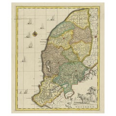
- Antique Map of Friesland 'The Netherlands' by B. Schotanus, 1664By B. SchotanusLocated in Langweer, NLHand-colored map of the Dutch province Friesland. Also shows the Wadden islands Vlieland, Terschelling and Ameland and a part of Schiermonnikoog. With a decorative cartouche with two...Category
Antique Late 17th Century Maps
MaterialsPaper
- Antique Map of the Region of Utingeradeel in Friesland, The Netherlands, 1664By B. SchotanusLocated in Langweer, NLAntique map titled 'De Grietenye van Utingeradeel (..)'. Map of the Grietenij of Utingeradeel, Friesland, The Netherlands. Multiple cartouches, key and coat of arms. "Beschrijvinge e...Category
Antique 17th Century Maps
MaterialsPaper
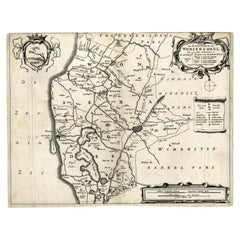
- Antique Map of the Region of Wonseradeel, Friesland in the Netherlands, 1664By B. SchotanusLocated in Langweer, NLAntique map titled 'De Grietenije van Wonsera-deel (..).' Map of the Grietenij of Wonseradeel, Friesland, The Netherlands. Multiple cartouches, key and coat of arms. "Beschrijvinge e...Category
Antique 17th Century Maps
MaterialsPaper
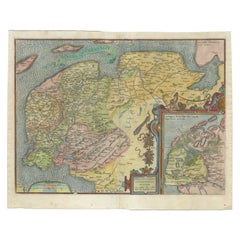
- Old Antique Map of the Province of Friesland, the Netherlands, c.1580Located in Langweer, NLAntique map titled 'Frisia Occidentalis'. Old map of the province of Friesland, the Netherlands. This map is also known as the 'Pauwenkaart' ('peacock map'), referring to the peacock next to the inset map. Based on a manuscript map...Category
Antique 16th Century Maps
MaterialsPaper
- Original Copper-Engraving of Westergo, Part of Friesland, the Netherlands, 1744Located in Langweer, NLAntique map titled 'Westergo'. Original antique map of Westergo, part of the province of Friesland, the Netherlands. Published 1744. Artists and engravers: Isaak Tirion (1705 ...Category
Antique 1740s Maps
MaterialsPaper
- Antique Map of Leeuwarderadeel in Friesland, The Netherlands, 1868Located in Langweer, NLAntique map titled 'Provincie Friesland - Gemeente Leeuwarderadeel'. Map of the township of Leeuwarderadeel including Friesland's Capital Leeuwarden and furthermore: Wirdum, Wytg...Category
Antique 19th Century Maps
MaterialsPaper

You May Also Like
- Antique 18th Century Map of the Province of Pensilvania 'Pennsylvania State'Located in Philadelphia, PAA fine antique of the colony of Pennsylvania. Noted at the top of the sheet as a 'Map of the province of Pensilvania'. This undated and anonymous map is thought to be from the Gentleman's Magazine, London, circa 1775, although the general appearance could date it to the 1760's. The southern boundary reflects the Mason-Dixon survey (1768), the western boundary is placed just west of Pittsburgh, and the northern boundary is not marked. The map has a number of reference points that likely refer to companion text and appear to be connected to boundaries. The western and southern boundaries are marked Q, R, S, for example. A diagonal line runs from the Susquehanna R to the Lake Erie P. A broken line marked by many letters A, B, N, O, etc., appears in the east. There are no latitude or longitude markings, blank verso. Framed in a shaped contemporary gilt wooden frame and matted under a cream colored matte. Bearing an old Graham Arader Gallery...Category
Antique 18th Century British American Colonial Maps
MaterialsPaper
- Map of the Republic of GenoaLocated in New York, NYFramed antique hand-coloured map of the Republic of Genoa including the duchies of Mantua, Modena, and Parma. Europe, late 18th century. Dimension: 25...Category
Antique Late 18th Century European Maps
- Map "Estuary- Mouth of the Thames"Located in Alessandria, PiemonteST/426 - Antique French Map of the estuary of the Thames, map dated 1769 - "Mape of the entrance of the Thames. Designed by filing of Navy cards fo...Category
Antique Mid-18th Century French Other Prints
MaterialsPaper
- Vintage "View of the Center of Paris Taken from the Air" Lithograph MapLocated in San Diego, CAA very stylish "View of the Center of Paris Taken from the Air" lithograph map published by the Paris Ministry of Tourism, circa early 1950s. The piece measures 27" x 43" and shows...Category
20th Century French Mid-Century Modern Prints
MaterialsPaper
- New Map of North America from the Latest Discoveries, 1763Located in Philadelphia, PAA fine antique 18th century map of the North American seaboard. Entitled "A New Map of North America from the Latest Discoveries 1763". By the Cartographer/Engraver - John Spil...Category
Antique Mid-18th Century English Georgian Maps
MaterialsPaper
- 17th Century Hand Colored Map of the Liege Region in Belgium by VisscherBy Nicolaes Visscher IILocated in Alamo, CAAn original 17th century map entitled "Leodiensis Episcopatus in omnes Subjacentes Provincias distincté divisusVisscher, Leodiensis Episcopatus" by Nicolaes Visscher II, published in Amsterdam in 1688. The map is centered on Liege, Belgium, includes the area between Antwerp, Turnhout, Roermond, Cologne, Trier and Dinant. This attractive map is presented in a cream-colored mat measuring 30" wide x 27.5" high. There is a central fold, as issued. There is minimal spotting in the upper margin and a tiny spot in the right lower margin, which are under the mat. The map is otherwise in excellent condition. The Visscher family were one of the great cartographic families of the 17th century. Begun by Claes Jansz Visscher...Category
Antique Late 17th Century Dutch Maps
MaterialsPaper


Recently Viewed
View AllMore Ways To Browse
Collecting Antique Keys
Keys Collectible Antique
The Shire
Antique Province Map
Map Of Antique Province
Antique Province Map Of Antique
Vans Coat Of Arms
Wood Carvings Of Ships
Classroom Furniture Used
Fine Antique Maps
17th Century World Map
Book Of Antique Maps
18th Century Southern Antiques
Antique French Globe
South African Antique Furniture
Antique Furniture South Africa
Antique Map Border
Compass Map