Items Similar to Scandinavia & Baltic Map – Antique by G. & L. Valk, incl. Sweden, Finland, c1700


Video Loading
Want more images or videos?
Request additional images or videos from the seller
1 of 12
Scandinavia & Baltic Map – Antique by G. & L. Valk, incl. Sweden, Finland, c1700
$623.35
$779.1920% Off
£463.06
£578.8320% Off
€520
€65020% Off
CA$865.59
CA$1,081.9920% Off
A$944.56
A$1,180.7020% Off
CHF 495.44
CHF 619.3020% Off
MX$11,472.04
MX$14,340.0420% Off
NOK 6,188.31
NOK 7,735.3920% Off
SEK 5,848.26
SEK 7,310.3320% Off
DKK 3,958.71
DKK 4,948.3820% Off
About the Item
Scandinavia & Baltic Map – Antique by G. & L. Valk, incl. Sweden, Finland, 1700
Antique map titled 'Sueciae Magnae, totius orbis regni antiquissimi (..)' by Gerard and Leonard Valk. This finely engraved map presents a detailed view of Scandinavia and the Baltic region, covering Norway, Sweden, Finland, Estonia, and Latvia. The map’s geographical accuracy reflects the period’s growing understanding of Northern Europe’s rugged landscapes, political boundaries, and coastal contours.
Published in Amsterdam in the early 18th century, this map reflects the legacy of the Valk family, prominent Dutch cartographers and publishers known for their beautifully hand-colored maps. The Valks carried on the tradition of Blaeu and Janssonius, preserving the rich visual language of Dutch Golden Age cartography, with ornate cartouches, strong linework, and careful geographical notations. The present map combines decorative appeal with historical significance, making it a prized piece for collectors interested in Northern Europe.
Condition: Very good, general age-related toning. Original hand coloring. Some minor margin imperfections and a light horizontal fold in the middle.
Framing tips: This map would pair well with a classic black or walnut frame and a cream or light grey mat to highlight its rich hand coloring and historical ambiance. It will make a striking centerpiece in any study, hallway, or library.
- Dimensions:Height: 24.02 in (61 cm)Width: 20.67 in (52.5 cm)Depth: 0.02 in (0.5 mm)
- Materials and Techniques:Paper,Engraved
- Place of Origin:
- Period:Late 17th Century
- Date of Manufacture:circa 1690 -1710
- Condition:Very good, original/contemporary hand coloring. Blank verso. General age-related toning, minor wear. Some minor margin imperfections and a light horizontal fold in the middle.
- Seller Location:Langweer, NL
- Reference Number:Seller: BG-122401stDibs: LU3054317445462
About the Seller
5.0
Recognized Seller
These prestigious sellers are industry leaders and represent the highest echelon for item quality and design.
Platinum Seller
Premium sellers with a 4.7+ rating and 24-hour response times
Established in 2009
1stDibs seller since 2017
2,641 sales on 1stDibs
Typical response time: <1 hour
- ShippingRetrieving quote...Shipping from: Langweer, Netherlands
- Return Policy
Authenticity Guarantee
In the unlikely event there’s an issue with an item’s authenticity, contact us within 1 year for a full refund. DetailsMoney-Back Guarantee
If your item is not as described, is damaged in transit, or does not arrive, contact us within 7 days for a full refund. Details24-Hour Cancellation
You have a 24-hour grace period in which to reconsider your purchase, with no questions asked.Vetted Professional Sellers
Our world-class sellers must adhere to strict standards for service and quality, maintaining the integrity of our listings.Price-Match Guarantee
If you find that a seller listed the same item for a lower price elsewhere, we’ll match it.Trusted Global Delivery
Our best-in-class carrier network provides specialized shipping options worldwide, including custom delivery.More From This Seller
View AllAntique Map of Scandinavia by T. Jefferys, circa 1750
Located in Langweer, NL
Antique map titled 'Sweden, Denmark, Norway & Finland'. An original mid-18th century copper engraved antique map of Scandinavia by Thomas Jefferys....
Category
Antique Mid-18th Century Maps
Materials
Paper

$182 Sale Price
20% Off
Map of Denmark Divided into Dioceses – G. & L. Valk, ca. 1690
Located in Langweer, NL
Map of Denmark Divided into Dioceses – G. & L. Valk, ca. 1700
Detailed antique map titled "Regnum Daniae, divisum in Dioeceses Arhusiam, Albergum, Viborgum, et Ripam," showing Denma...
Category
Antique Late 17th Century Maps
Materials
Paper

$527 Sale Price
20% Off
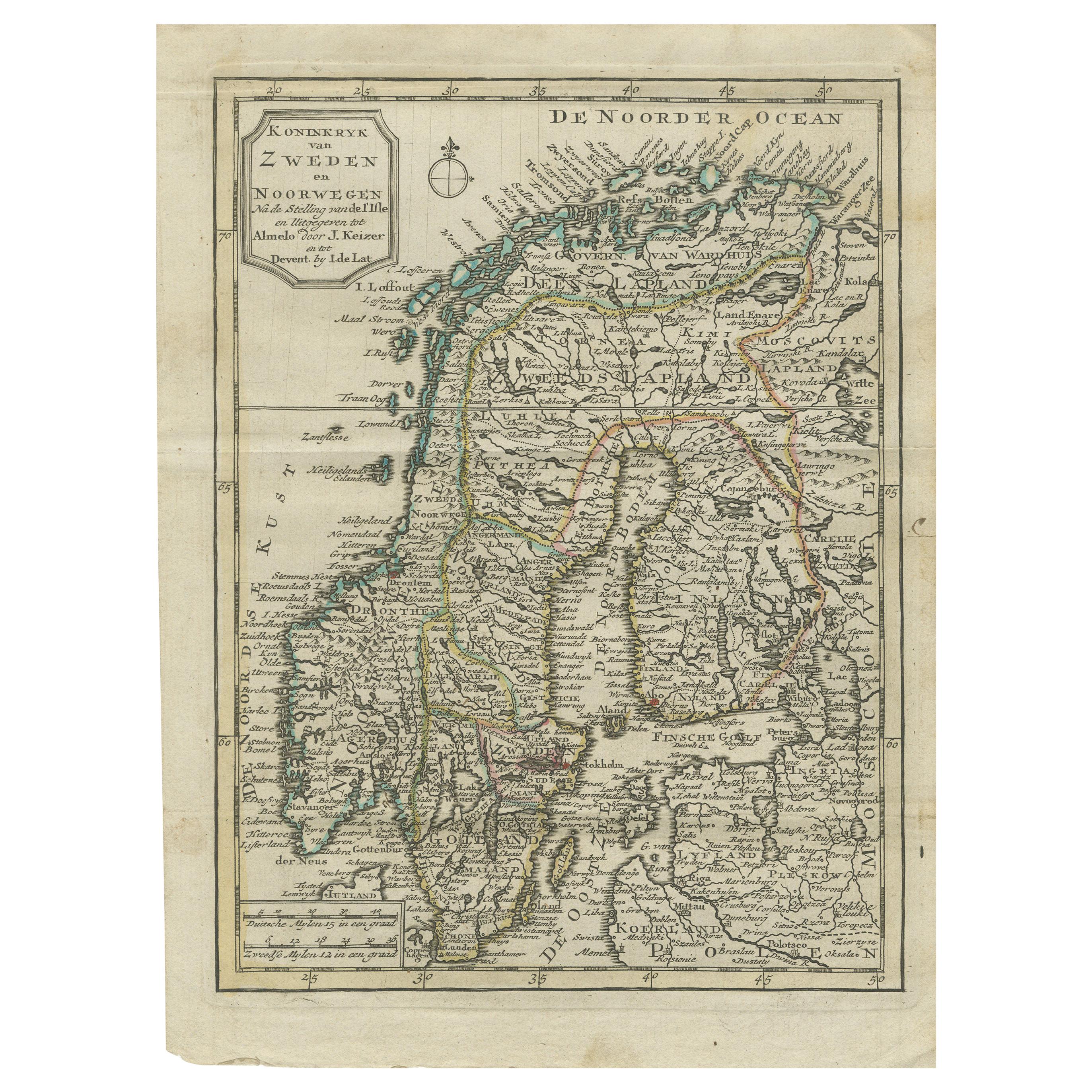
Antique Map of the Kingdom of Sweden and Norway by Keizer & de Lat, 1788
Located in Langweer, NL
Antique map titled 't Koninkryk van Zweden en Noorwegen'. Uncommon original antique map of the Kingdom of Sweden and Norway. This map originates from 'Nieuwe Natuur- Geschied- en Han...
Category
Antique Late 18th Century Maps
Materials
Paper
$335 Sale Price
20% Off
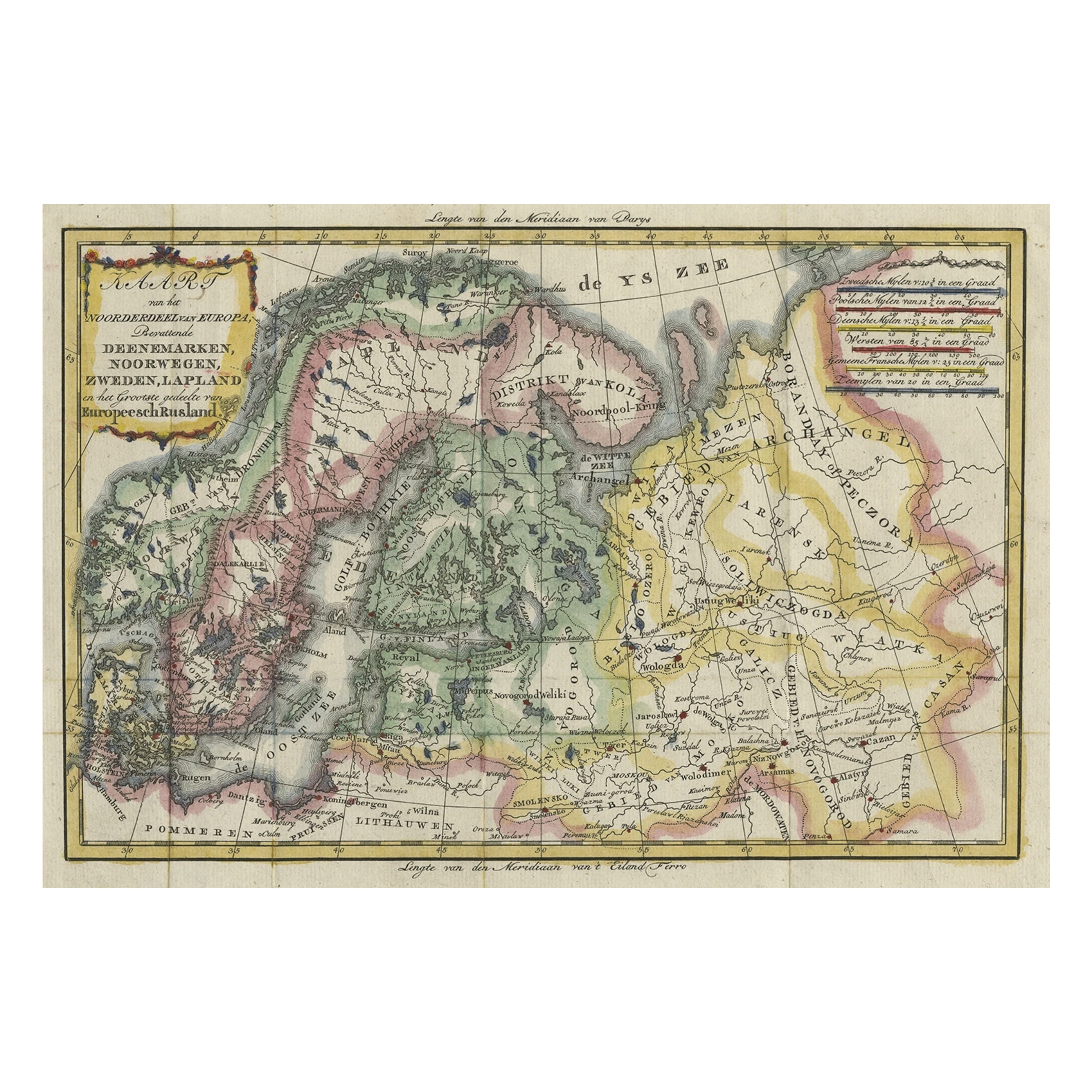
Uncommon Old Map of Lapland to Russia and Denmark to Kazan in the South, 1785
Located in Langweer, NL
Description: Antique map titled 'Kaart van het Noorderdeel van Europa, Bevattende Deenmarken, Noorwegen, Zweden, Lapland en het Grootste Gedeelte van Europeesch Rusland.'
This un...
Category
Antique 1780s Maps
Materials
Paper
$527 Sale Price
20% Off
Antique Map of Scandinavia by Van der Aa 'circa 1710'
Located in Langweer, NL
Antique map titled 'Scandinavie Septentrionale' and 'Scandinavie Meridionale'. Copper engraving with two maps on one sheet. The upper map depicts Northern Scandinavia with Norway, Sw...
Category
Antique Early 18th Century Maps
Materials
Paper

$671 Sale Price
20% Off
Antique Map of Denmark with Details of Fortresses, Cities, Towns Etc, c.1680
Located in Langweer, NL
Antique map of Denmark titled 'Insularum Danicarum ut Zee-Landiae, Fioniae, Langelandiae, Lalandiae Falstriae, Fembriae, Monae (..)'. This map depicts the main Danish Islands and a s...
Category
Antique 17th Century Maps
Materials
Paper

$719 Sale Price
20% Off
Free Shipping
You May Also Like
Original Antique Map of Sweden, Engraved by Barlow, 1806
Located in St Annes, Lancashire
Great map of Sweden
Copper-plate engraving by Barlow
Published by Brightly & Kinnersly, Bungay, Suffolk. 1806
Unframed.
Category
Antique Early 1800s English Maps
Materials
Paper

Sweden and Adjacent Portions of Scandinavia: A Hand-colored 18th C. Homann Map
By Johann Baptist Homann
Located in Alamo, CA
This hand-colored copper-plate map of Sweden and adjacent portions of Scandinavia entitled "Regni Sueciae in Omnes suas Subjacentes Provincias accurate divisi Tabula Generalis" was c...
Category
Early 18th Century Old Masters Landscape Prints
Materials
Engraving

1646 Jansson Map Entitled "Procinvia Connactiae, " Ric.a006
Located in Norton, MA
1646 Jansson map entitled
"Procinvia connactiae,"
Ric.a006
Description: The PROVINCE of CONNAVGT 490 x 380From vol 4 of Jansson's Atlas Novus 1646, published in Amsterdam with...
Category
Antique 17th Century Unknown Maps
Materials
Paper

17th Century Map of Denmark by French Cartographer Sanson, Dated 1658
By Nicolas Sanson
Located in Copenhagen, K
17th century map of Denmark by French cartographer Sanson.
Nicolas Sanson (20 December 1600-7 July 1667) was a French cartographer, termed by some the creator of French geography an...
Category
Antique 17th Century French Maps
Materials
Paper

1790 Thomas Stackhouse Map, Entitled "Russia in Europe, " , Ric.a004
Located in Norton, MA
1790 Thomas Stackhouse map, entitled
"Russia in Europe"
Ric.a004
Stackhouse, Thomas
Russia in Europe [map]
London: T. Stackhouse, 1783. Map. Matted hand-colored copper engraving. Image size: 14.5 x 15.25 inches. Mat size: 22.75 x 23.75 inches. A beautiful example of this map of Eastern Europe...
Category
Antique 17th Century Unknown Maps
Materials
Paper

1636 Jansson Map of Ireland Entitled "Comitatus Lageniae, " Ric.a007
Located in Norton, MA
1646 Jansson map entitled
"Procinvia connactiae,"
Ric.a006
Description: The PROVINCE of CONNAVGT 490 x 380From vol 4 of Jansson's Atlas Novus 1646, published in Amsterdam with...
Category
Antique 17th Century Unknown Maps
Materials
Paper

More Ways To Browse
Swedish 17th Century Furniture
Map Of India
Antique Maps Amsterdam
Antique Maps Of Russia
19th Century Map Of Africa
Map Of Britain
Railroad Furniture
Antique Malaysia
Blaeu Maps
Antique Topographic Maps
Antique Maps Of North America
Antique Maps Of Italy
Antique Navigator
Antique Maps Of Britain
Wood Furniture Bali
Scotland Map
Antique Maps Scotland
Furniture Russian 18th Century