Items Similar to Striking Antique View of Kozhikode, also known as Calicut, in Kerala, India
Want more images or videos?
Request additional images or videos from the seller
1 of 7
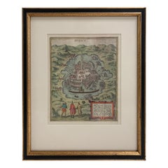
Striking Antique View of Kozhikode, also known as Calicut, in Kerala, India
$422.38
$527.9720% Off
£311.49
£389.3620% Off
€352
€44020% Off
CA$583.30
CA$729.1220% Off
A$640.02
A$800.0220% Off
CHF 334.96
CHF 418.6920% Off
MX$7,876.44
MX$9,845.5520% Off
NOK 4,219.93
NOK 5,274.9220% Off
SEK 3,952.60
SEK 4,940.7520% Off
DKK 2,680.91
DKK 3,351.1420% Off
About the Item
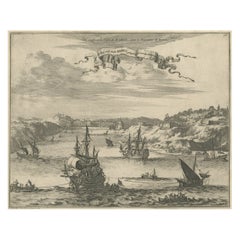
Antique print titled 'Calechut'. Wonderful, miniature copper engraving depicting Arion riding on a very cheerful looking sea monster in the important trading center of Calicut harbor. The Latin title at top roughly translates to "Music from the Stars Soothes the Sea Monster." The city is shown in the background, with truly exceptional detail of the buildings, elephants, palm trees, and landscape. This engraving is based on Braun & Hogenberg's view of 1572.
Meisner's emblem book, containing over 800 pictorial-poetic compositions, was enormously popular throughout Europe in the 17th century. The plan views were based on the work of De Bry, Braun & Hogenberg, Merian and others with the addition of emblematic figures or scenes in the foreground, juxtaposed with moralizing and edifying verses beneath the image and a Latin motto at top. It was originally issued with 52 plates as the Thesaurus philo-politicus in 1623-24. After Meisner's death in 1625, Eberhard Kieser, with assistance from Johann L. Gottfried, completed the work and published it until 1631. The plates then appeared in the eight parts of Sciographia Cosmica published by Paulus Furst between 1637-78. The plates for these editions were renumbered alphanumerically in the upper right corners. They were finally issued in 1700 and 1704 in Rudolf J. Helmer's Politica-politica. This example is from the 1642 edition.
- Dimensions:Height: 5.71 in (14.5 cm)Width: 6.89 in (17.5 cm)Depth: 0.02 in (0.5 mm)
- Materials and Techniques:
- Period:Mid-17th Century
- Date of Manufacture:c.1642
- Condition:Wear consistent with age and use. General age-related toning. Strong impression, minor soiling. There is a small stain in right blank margin. Blank verso. Please study images carefully.
- Seller Location:Langweer, NL
- Reference Number:Seller: BG-133381stDibs: LU3054331030762
About the Seller
5.0
Recognized Seller
These prestigious sellers are industry leaders and represent the highest echelon for item quality and design.
Platinum Seller
Premium sellers with a 4.7+ rating and 24-hour response times
Established in 2009
1stDibs seller since 2017
2,618 sales on 1stDibs
Typical response time: <1 hour
- ShippingRetrieving quote...Shipping from: Langweer, Netherlands
- Return Policy
Authenticity Guarantee
In the unlikely event there’s an issue with an item’s authenticity, contact us within 1 year for a full refund. DetailsMoney-Back Guarantee
If your item is not as described, is damaged in transit, or does not arrive, contact us within 7 days for a full refund. Details24-Hour Cancellation
You have a 24-hour grace period in which to reconsider your purchase, with no questions asked.Vetted Professional Sellers
Our world-class sellers must adhere to strict standards for service and quality, maintaining the integrity of our listings.Price-Match Guarantee
If you find that a seller listed the same item for a lower price elsewhere, we’ll match it.Trusted Global Delivery
Our best-in-class carrier network provides specialized shipping options worldwide, including custom delivery.More From This Seller
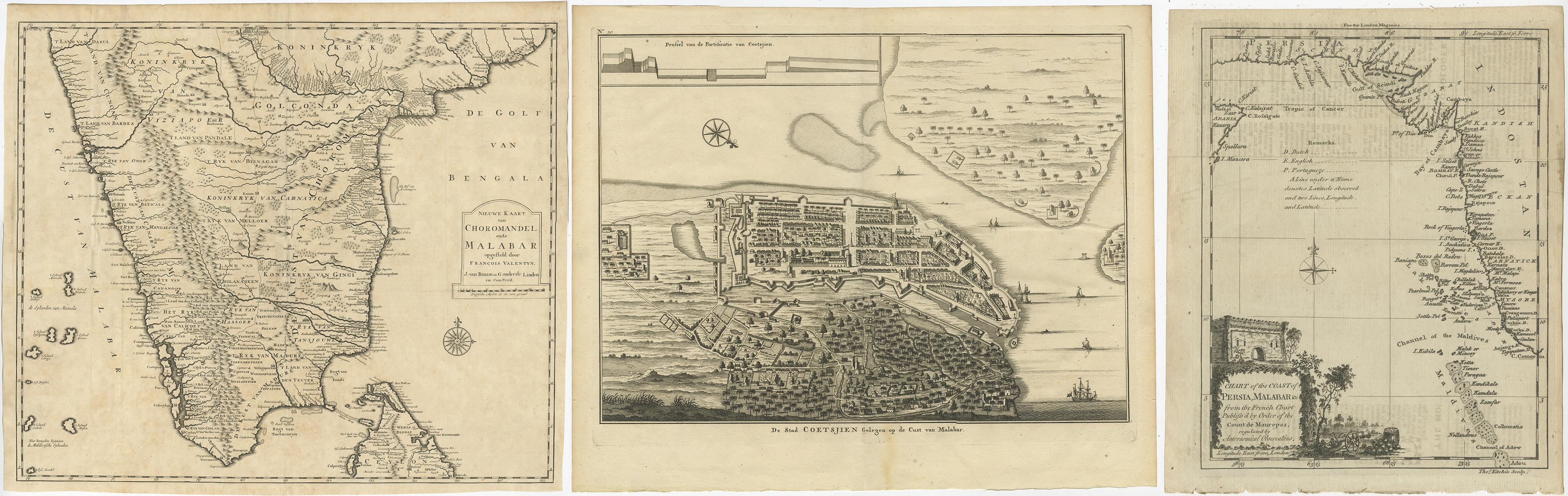
View AllAntique Maps of the Malabar Coast – Valentyn, Cochin, and Malabar, 17
Located in Langweer, NL
Antique Maps of the Malabar Coast – Valentyn, Cochin, and London Magazine, 17th–18th Century
Description:
This compilation of three antique maps and views offers a remarkable cross-...
Category
Antique 19th Century Maps
Materials
Paper
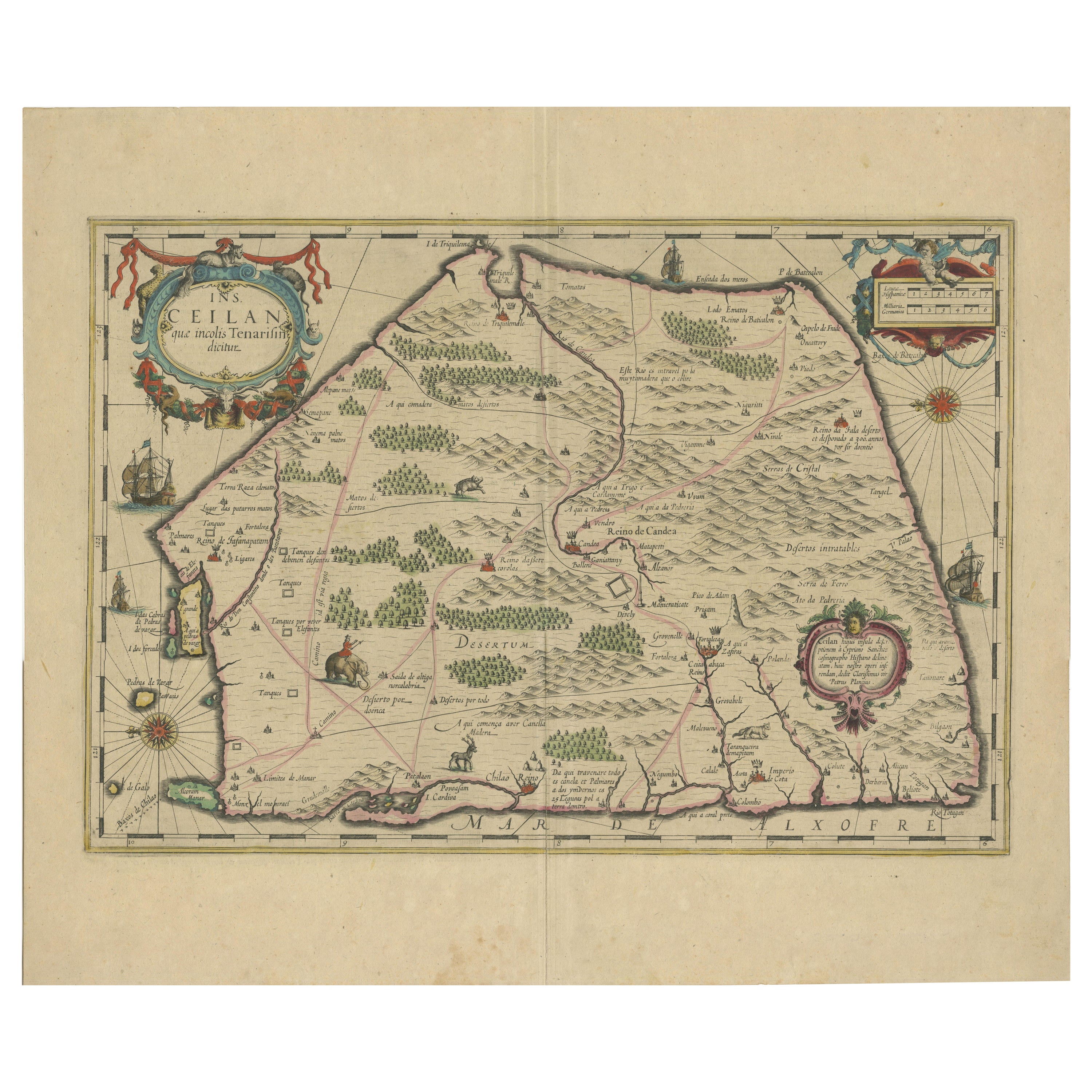
1638 Plancius Detailed Map of Sri Lanka or Ceylon with Decorative Cartouches
Located in Langweer, NL
"1638 Plancius Detailed Map of Sri Lanka with Decorative Cartouches"
This beautifully detailed map of Sri Lanka, titled "Ins. Ceilan," was engraved by P. Plancius from a design by C...
Category
Antique 1630s Maps
Materials
Paper
$1,382 Sale Price
20% Off
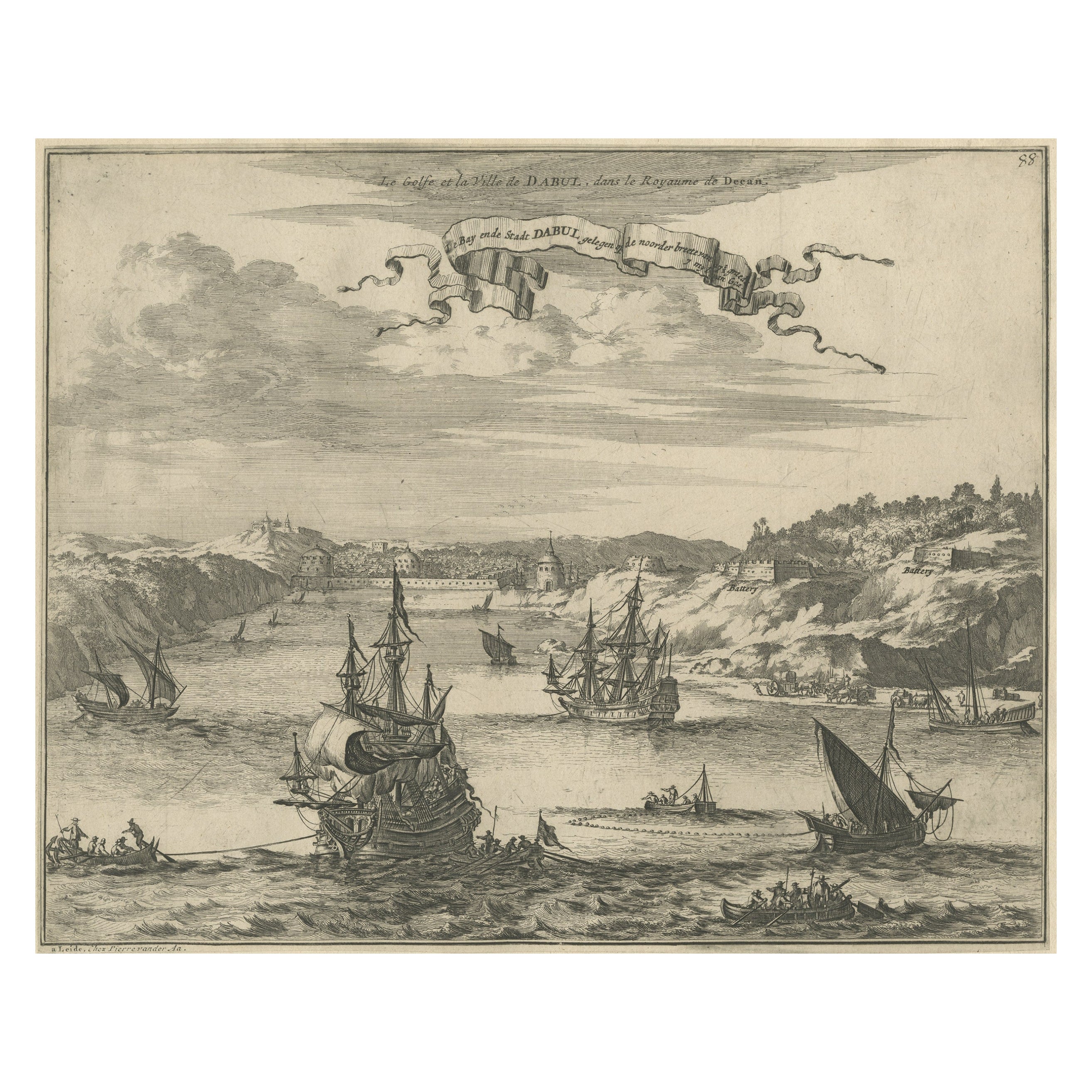
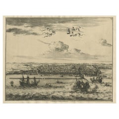
Bird's Eye View of Dabhol as Seen from the Sea, North of Goa, India, 1727
Located in Langweer, NL
Antique print titled 'De Bay ende Stadt Dabul'.
Bird's eye view of Dabhol as seen from the sea. The city is situated on the Vashishti river, north of Goa in India, on the Malabar...
Category
Antique 1720s Maps
Materials
Paper
$518 Sale Price
20% Off
Free Shipping
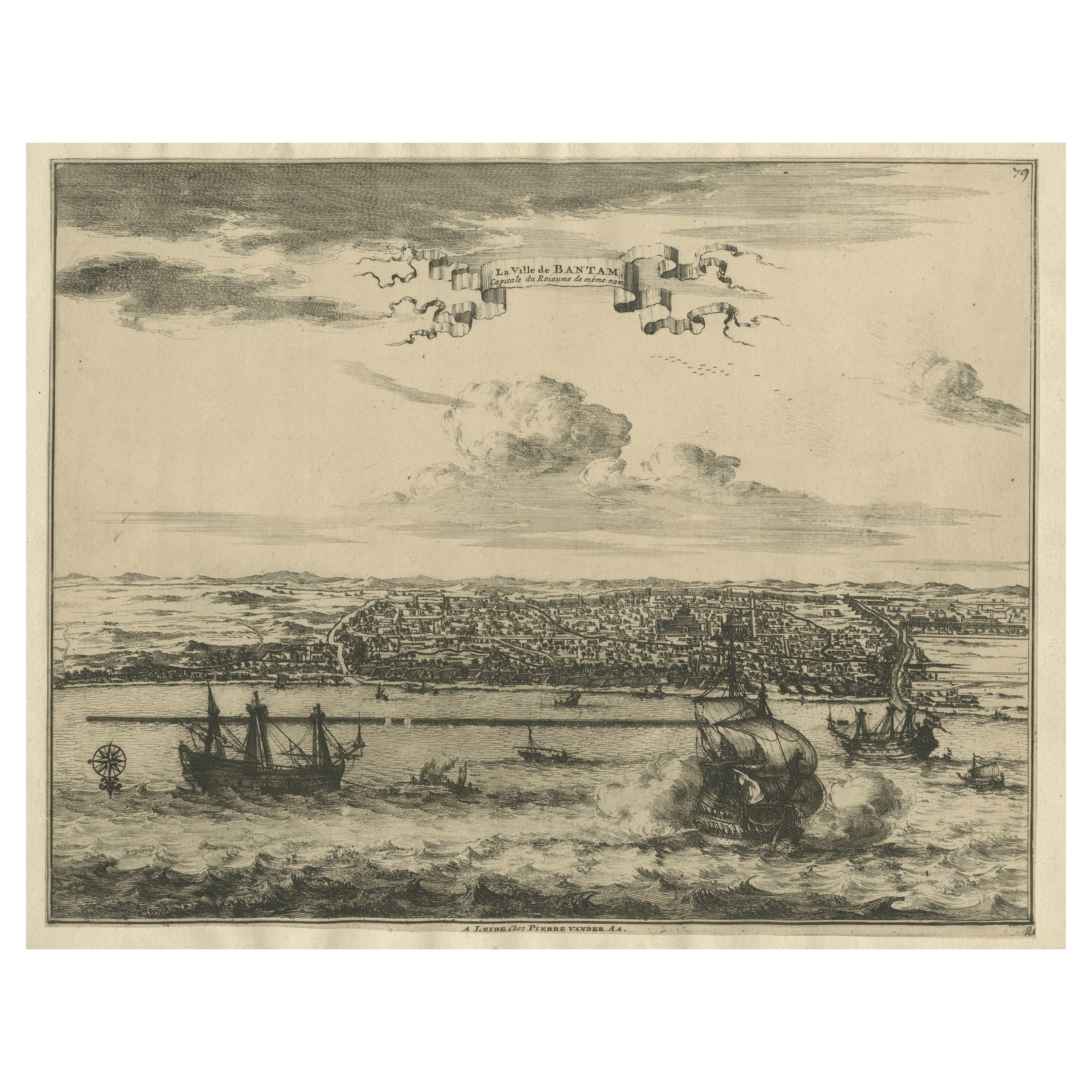
View of the City Banten or Bantam Near the Western End of Java, Indonesia, c1725
Located in Langweer, NL
Antique print titled 'La Ville de Bantam capitale du Roiaume de meme nom'.
A bird's eye view of the city Banten or Bantam near the western end of Java in Indonesia. Several tall ...
Category
Antique 1720s Maps
Materials
Paper
$710 Sale Price
20% Off
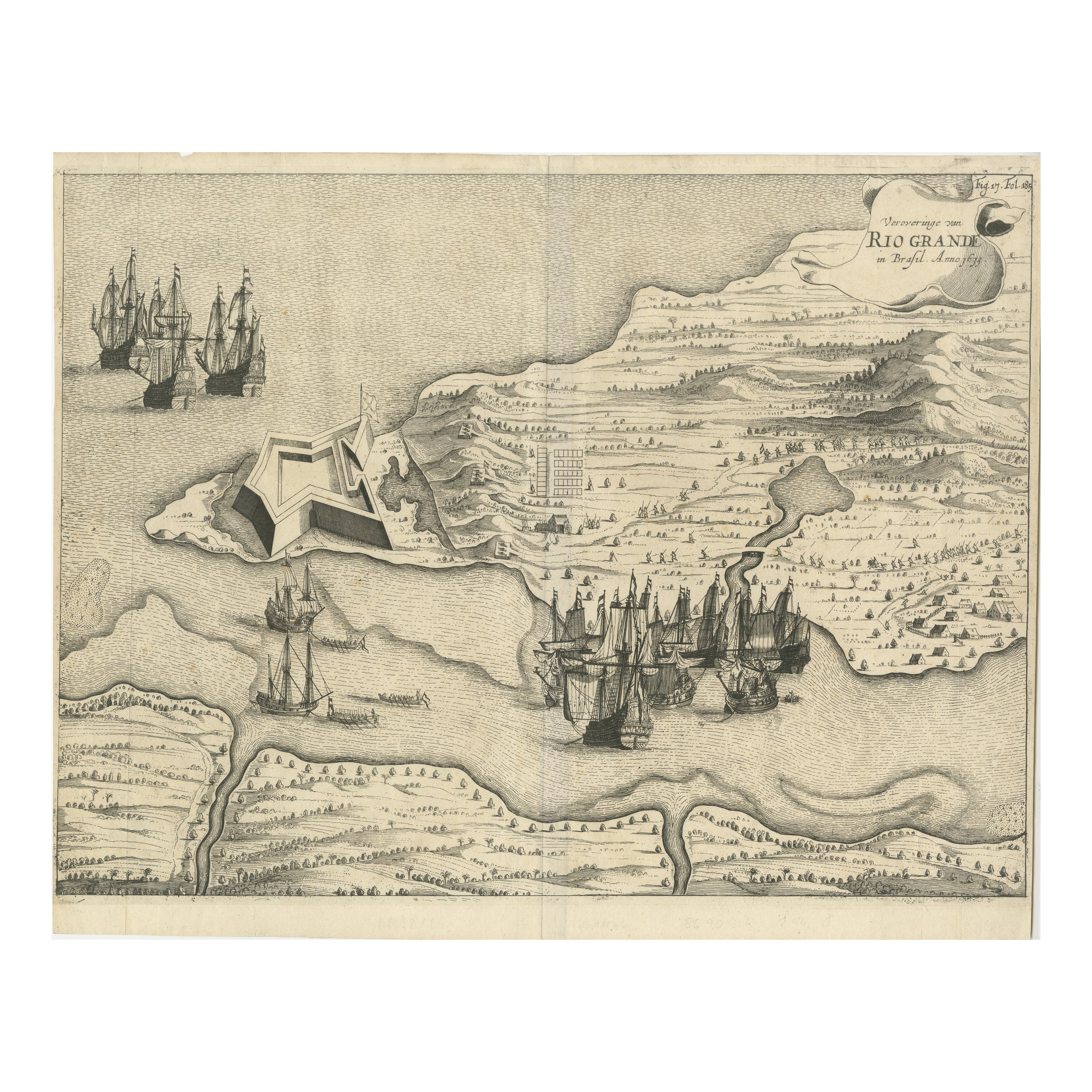
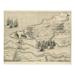
Dutch Conquest of Rio Grande, Brazil (1633) Under Prince Frederick Hendrick
Located in Langweer, NL
The image is an engraving titled “VEROVERINGE VAN RIO GRANDE IN BRASIL ANNO 1633.” This historical print depicts the Dutch conquest of Rio Grande in Brazil, known today as Natal, dur...
Category
Antique 1690s Maps
Materials
Paper
$527 Sale Price
20% Off
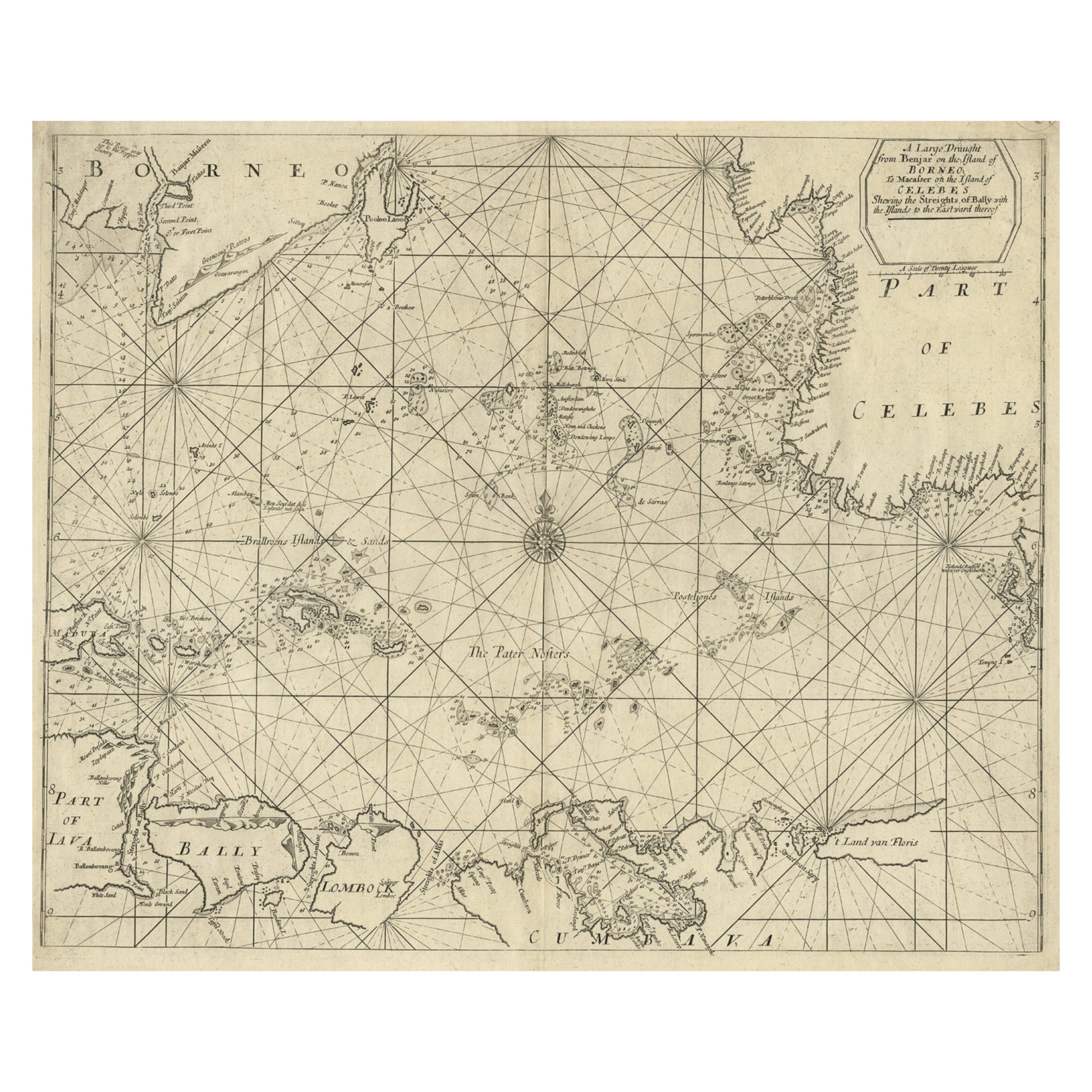
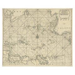
Rare Antique English SeaChart of Bali, Lombok, Floris, Borneo, Celebes etc, 1711
Located in Langweer, NL
Antique map titled 'A Large Draught from Benjar on the Island of Borneo To Macasser on the Island of Celebes Shewing the Streight of Bally with the Islands to the Eastward thereof.' ...
Category
Antique 1710s Maps
Materials
Paper
$2,351 Sale Price
20% Off
You May Also Like
1633 Map "La Souverainete De Sedan Et De Raucourt, Et La Prevoste Ric0011
Located in Norton, MA
1653 map entitled
"La Souverainete de Sedan et de Raucourt, et la Prevoste de Doncheri,"
Ric0011
Description:
Lovely map centered on Sedan and Doncheri and the Meuze River fr...
Category
Antique 17th Century Dutch Maps
Materials
Paper

1597 German Map of Alexandria by Georg Braun and Frans Hogenberg
By Georg Braun and Frans Hogenberg
Located in Chapel Hill, NC
1597 Map of Alexandria by Georg Braun and Frans Hogenberg, Germany. From "Civitas Orbis Terrarum", part 2, published in Cologne by Bertram Buchholz. Printed in 2 parts. Title: "Alexa...
Category
Antique 16th Century German Renaissance Maps
Materials
Paper

Mexico City by Braun & Hogenberg c. 1590
By Georg Braun and Frans Hogenberg
Located in Stamford, CT
Mexico by Braun & Hogenberg c. 1590
Category
Antique Mid-19th Century European Spanish Colonial Maps
Materials
Glass, Wood, Paper
1656 "La Souverainete de Sedan et de Raucourt, et la Prevoste de Doncheri Ric004
Located in Norton, MA
1656 map entitled
"La Souverainete de Sedan et de Raucourt, et la Prevoste de Doncheri,"
Hand Colored
Ric0004.
Description:
Lovely map centered on Sedan and Doncheri an...
Category
Antique 17th Century Dutch Maps
Materials
Paper
1640 Flandriae Partes Duae Quarum Altera Proprietaria, Ric0016
Located in Norton, MA
1640 Willem and Joan Blaeu map entitled
"Flandriae Partes duae quarum altera Proprietaria, altera Imperialis vulgo dictur,"
Ric0016
(Mounted on Carboard)
Willem Janszoon Blaeu...
Category
Antique 17th Century Dutch Maps
Materials
Paper
Antique Voc Print Holland Malaysia Old Map Melaka History, 1663
Located in Amsterdam, Noord Holland
From my own collection I offer this impressive Antique print of the city of Malakka
A very interesting piece for collectors . It is an museum piece from the Dutch Institute of Orien...
Category
Antique 17th Century European Paintings
Materials
Paper

$293 Sale Price
20% Off
More Ways To Browse
Antique Furniture In India
India Miniature
Sea Monster
Kerala Antique
Kerala Antique Furniture
Antique Copper Australia
Antique Furniture Pondicherry
Antique Map Of Cornwall
Antique Maps Dublin
Antique Maps Of Malta
Antique Saudi Arabia
Armenia Map
Cambodia Antique Map
Charles Hutchinson
Coronelli Globe
Denoyer Geppert Anatomy
E Fletcher
Framed Africa Maps