Items Similar to Gregory's 1861 Expedition into the North West of Australia, 1862
Want more images or videos?
Request additional images or videos from the seller
1 of 8
Gregory's 1861 Expedition into the North West of Australia, 1862
$277.46
$346.8320% Off
£204.69
£255.8720% Off
€232
€29020% Off
CA$384.11
CA$480.1320% Off
A$416.48
A$520.6020% Off
CHF 221.02
CHF 276.2820% Off
MX$5,129.52
MX$6,411.9120% Off
NOK 2,739.44
NOK 3,424.3020% Off
SEK 2,585.40
SEK 3,231.7520% Off
DKK 1,766.34
DKK 2,207.9220% Off
About the Item
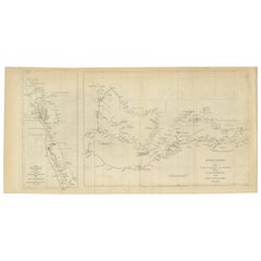
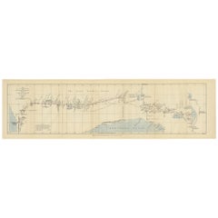
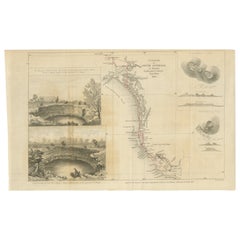
The map represents the route taken during F.T. Gregory's 1861 North West Australian Expedition.
This exploration was a significant journey that took place over the Pilbara region, starting from the Ashburton River and extending to the Dampier Archipelago and the De Grey River.
Francis Thomas Gregory led the expedition on the ship 'Dolphin', arriving at Nickol Bay in May 1861. The objective of the expedition was initially to assess the land's suitability for cotton cultivation, but it ended up having a profound impact on the region's development, particularly in the pastoral industry.
Gregory and his team, likely the first Europeans to witness vast swathes of this landscape, were instrumental in encouraging settlers to move to the Pilbara, not only from other parts of Western Australia but also from the eastern colonies and Victoria. Interestingly, Gregory also observed the presence of iron ore in the Pilbara; however, this resource would not be significantly tapped into until the late 20th century.
For his efforts in leading this and other expeditions, Gregory was awarded the founder's medal of the Royal Geographical Society in 1863. His detailed reports from these explorations served as guidebooks for those looking to establish pastoral and pearling operations in the north. Additionally, he collected numerous botanical and geological specimens, which would later be displayed in museums such as Charles Nicolay's in Fremantle.
After his time in Western Australia, Gregory moved to Queensland in 1862, where he continued to contribute to the expansion and exploration of Australia, serving in several official capacities including commissioner of crown lands.
- Dimensions:Height: 8.39 in (21.3 cm)Width: 14.97 in (38 cm)Depth: 0 in (0.02 mm)
- Materials and Techniques:
- Period:
- Date of Manufacture:1862
- Condition:Good. Folds as issued with a few tears on the folding lines. Two tears backed with archival tape. Study the images carefully.
- Seller Location:Langweer, NL
- Reference Number:Seller: BG-13699-41stDibs: LU3054338355872
About the Seller
5.0
Recognized Seller
These prestigious sellers are industry leaders and represent the highest echelon for item quality and design.
Platinum Seller
Premium sellers with a 4.7+ rating and 24-hour response times
Established in 2009
1stDibs seller since 2017
2,620 sales on 1stDibs
Typical response time: <1 hour
- ShippingRetrieving quote...Shipping from: Langweer, Netherlands
- Return Policy
Authenticity Guarantee
In the unlikely event there’s an issue with an item’s authenticity, contact us within 1 year for a full refund. DetailsMoney-Back Guarantee
If your item is not as described, is damaged in transit, or does not arrive, contact us within 7 days for a full refund. Details24-Hour Cancellation
You have a 24-hour grace period in which to reconsider your purchase, with no questions asked.Vetted Professional Sellers
Our world-class sellers must adhere to strict standards for service and quality, maintaining the integrity of our listings.Price-Match Guarantee
If you find that a seller listed the same item for a lower price elsewhere, we’ll match it.Trusted Global Delivery
Our best-in-class carrier network provides specialized shipping options worldwide, including custom delivery.More From This Seller
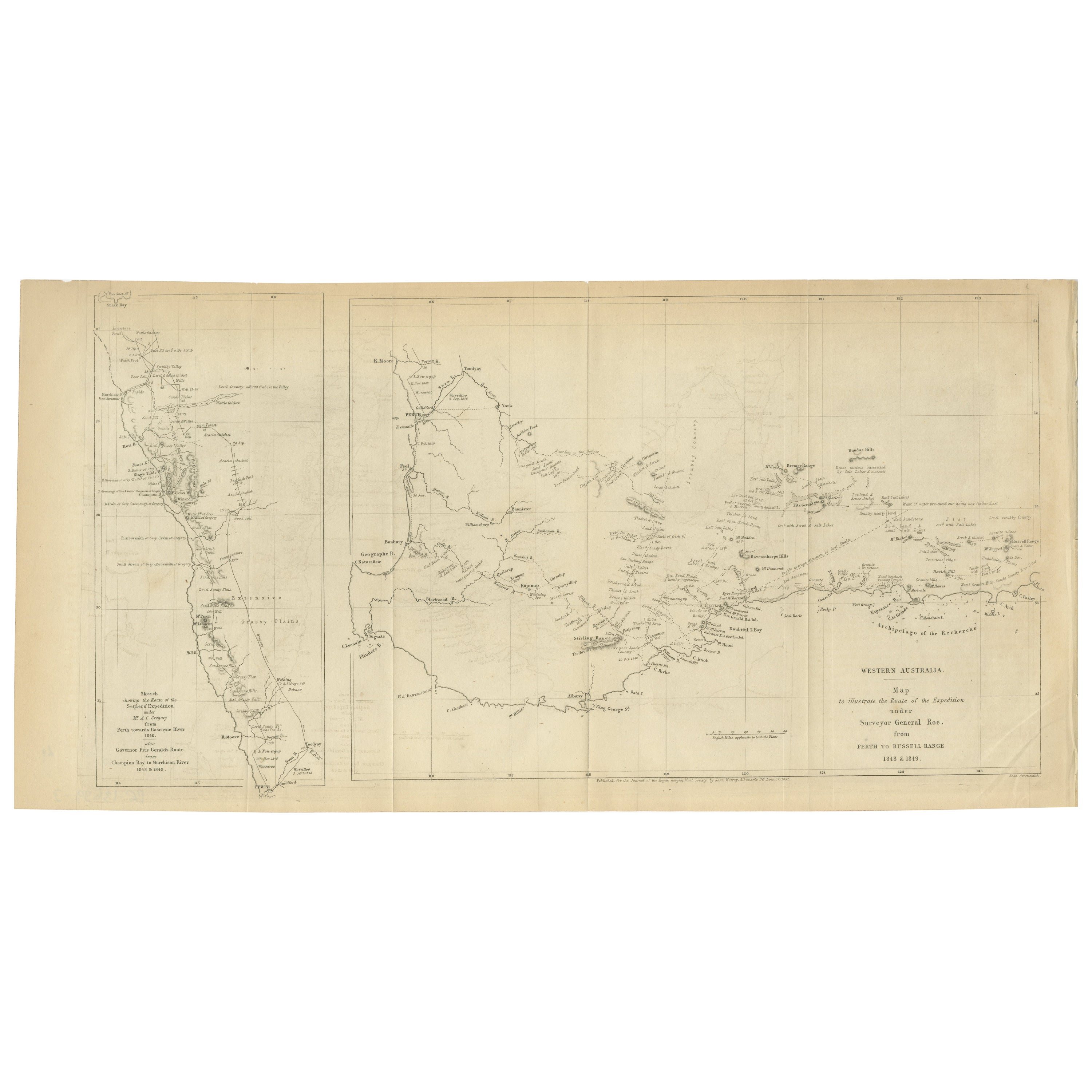
View AllCharting the West: Surveyor General Roe’s Western Australian Expedition , 1852
Located in Langweer, NL
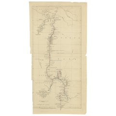
This map is a historical document, focused on Western Australia. It illustrates the route of an expedition under Surveyor General Roe from Perth to Russell Range during 1848 and 1849...
Category
Antique 1850s Prints
Materials
Paper
$277 Sale Price
20% Off
Free Shipping
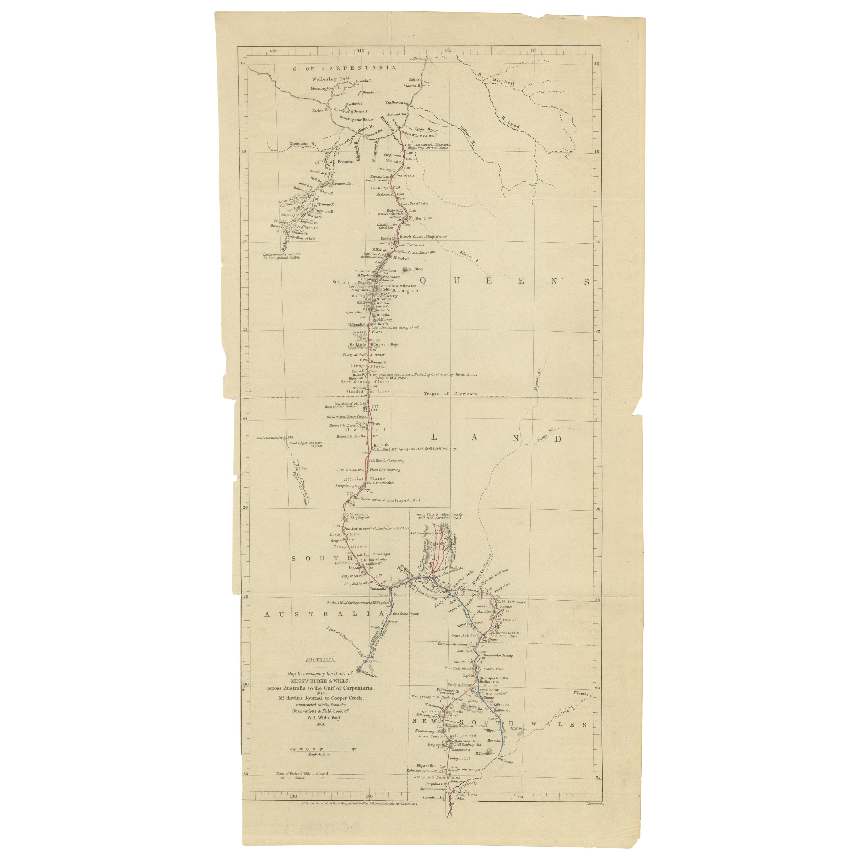
The Fateful Track of The Burke and Wills Expedition in Australia's Outback, 1862
Located in Langweer, NL
The map depicts the route of the Burke and Wills expedition, one of the most famous and tragic explorations in Australian history. This journey was the first to cross the Australian ...
Category
Antique 1860s Prints
Materials
Paper
$258 Sale Price
20% Off
Free Shipping
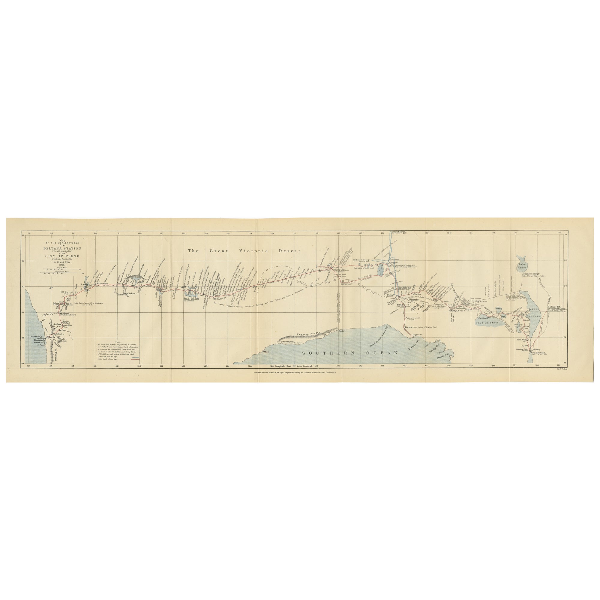
The 4000km Exploration of Ernest Giles from Beltena to Perth, Australia in 1875
Located in Langweer, NL
The map shows the route of the 1875 exploration led by Ernest Giles from Beltana Station in South Australia to the city of Perth in Western Australia. This was Giles' fourth and most...
Category
Antique 1870s Prints
Materials
Paper
$277 Sale Price
20% Off
Free Shipping
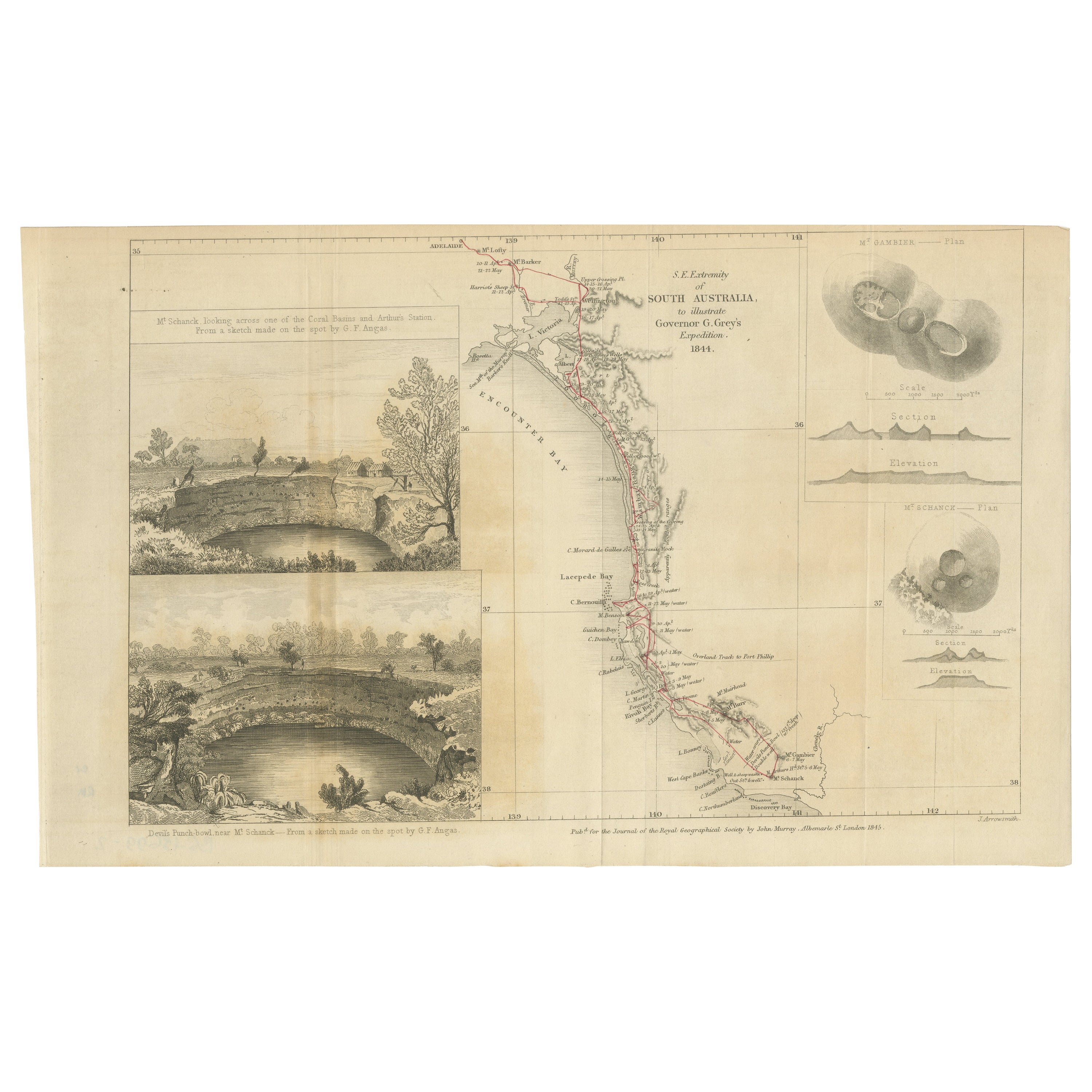
Traversing the Volcanic Frontier: A South Australian Expedition of 1844
Located in Langweer, NL
This is a historical document and part of a map and illustration from an expedition. The text indicates it is from South Australia to illustrate Governor G. Grey's Expedition in 1841...
Category
Antique 1840s Prints
Materials
Paper
$258 Sale Price
20% Off
Free Shipping
Antique Exploration Map of Australia from Sharks Bay to Alice Springs, 1876
Located in Langweer, NL
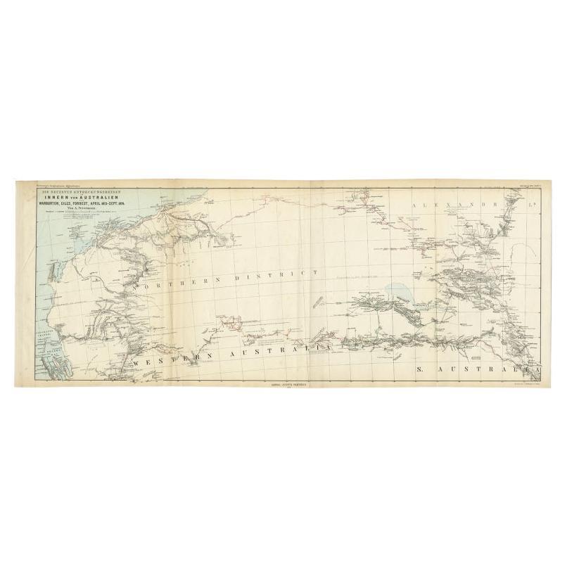
Antique map titled 'Die neuesten Entdeckungsreisen Innern von Australien von Warburton, Giles, Forrest (..)'. Old map of Australia from Sharks Bay to 90 Mile Beach over to Alice Springs...
Category
Antique 19th Century Maps
Materials
Paper
$239 Sale Price
20% Off
Antique Exploration Map of Australia from Beltana to Perth, 1876
Located in Langweer, NL
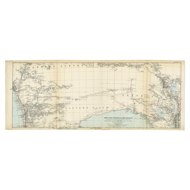
Antique map titled 'Thomas Elders' Expedition durch Inner-Australien von Beltana im Osten bis Perth im Western ausgefuhrt durch E. Giles (..)'. Old map of Australia from Bunbury to A...
Category
Antique 19th Century Maps
Materials
Paper
$239 Sale Price
20% Off
You May Also Like
Ancient National Atlas of France with Marengo
Located in Alessandria, Piemonte
Ancient National Atlas of France with the department of Marengo: a rare French etching dated 1806.
ST/178.
Category
Antique Early 19th Century French Other Prints
Materials
Paper

Large Original Antique Map of Australia by Sidney Hall, 1847
Located in St Annes, Lancashire
Great map of Australia
Drawn and engraved by Sidney Hall
Steel engraving
Original colour outline
Published by A & C Black. 1847
Unframed
Free shipping.
Category
Antique 1840s Scottish Maps
Materials
Paper

Original Antique Map of Australia by Dower, circa 1835
Located in St Annes, Lancashire
Nice map of Australia
Drawn and engraved by J.Dower
Published by Orr & Smith. C.1835
Unframed.
Free shipping
Category
Antique 1830s English Maps
Materials
Paper

Australia, Tallis antique map, 1851
Located in Melbourne, Victoria
'Australia'
With decorative border surrounds and vignettes including a view of Sydney, Kangaroos, Natives of Australia Felix, Australian Parrots and Cockatoos and Natives of the Tri...
Category
19th Century Naturalistic Landscape Prints
Materials
Engraving

Original Antique Decorative Map of South America-West Coast, Fullarton, C.1870
Located in St Annes, Lancashire
Great map of Chili, Peru and part of Bolivia
Wonderful figural border
From the celebrated Royal Illustrated Atlas
Lithograph. Original color.
Published by Fullarton, Edi...
Category
Antique 1870s Scottish Maps
Materials
Paper

1851 Map of "Independent Tartary", Ric. R018
Located in Norton, MA
1851 Map of
Independent Tartary
"Russia"
Ric.r018
A highly decorative 1851 map of Independent Tartary by John Tallis and John Rapkin. Covers the regions between the Caspian Sea and Lake Bakquash and between Russia and Afghanistan. These include the ancient Silk Route kingdoms of Khiva, Tartaria, Kokand, and Bokhara. Today this region roughly includes Kazakhstan, Uzbekistan, Turkmenistan, Kyrgyzstan, and Tajikistan. This wonderful map offers a wealth of detail for anyone with an interest in the Central Asian portion of the ancient Silk Road. Identifies various caravan routes, deserts, wells, and stopping points, including the cities of Bokhara and Samarkand. Three vignettes by W. Bragg decorate the map, these including an image of Tartars on a Journey, a horseback Bride Chase, and a tartar camp site. Surrounded by a vine motif border. Engraved by J. Rapkin for John Tallis's 1851 Illustrated Atlas .
Tartary Antique Map...
Category
Antique 19th Century Unknown Maps
Materials
Paper

More Ways To Browse
Antique Smoking Set
Antique Solingen
Antique Stable Door
Antique Staffordshire Cows
Antique Stirrup Cup
Antique Teapoy
Antique Tool Chest
Antique Wedgwood Dishes
Antique Wood Beams
Arabia Finland Kaj Franck
Arabic Plates
Art Deco Automobile
Art Deco Lizard
Art Nouveau Horn
Arte Vetraria Muranese (AVEM) On Sale
Ashford Marble
Ashley Wood
Asian Coins