Items Similar to Antique Map Showing the Religions Around the World by Johnston '1854'


Want more images or videos?
Request additional images or videos from the seller
1 of 6
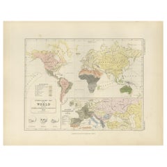
Antique Map Showing the Religions Around the World by Johnston '1854'
About the Item
Antique map titled 'Moral & Statistical Chart showing the Geographical Distribution of Man According to Religious Belief'. Rare large-size thematic map on the distribution of religions around the world, shown with different colours and diagrams. Shows the Catholics, Protestants, Mohammedans, Jews and Pagans. Three side maps show the distribution of missions in India, South Africa and Canada. Two maps of Europe for languages and religions. This map originates from the 'Physical Atlas' by W. & A.K. Johnston. Published by William Blackwood & Son, 1854.
- Dimensions:Height: 21.66 in (55 cm)Width: 26.38 in (67 cm)Depth: 0.02 in (0.5 mm)
- Materials and Techniques:
- Period:
- Date of Manufacture:1854
- Condition:General age-related toning. Original folding line. Shows some creasing, mainly on the corners of the map. Small split on folding line, minor spotting. Please study images carefully.
- Seller Location:Langweer, NL
- Reference Number:Seller: BG-128931stDibs: LU3054323599372
About the Seller
5.0
Platinum Seller
These expertly vetted sellers are 1stDibs' most experienced sellers and are rated highest by our customers.
Established in 2009
1stDibs seller since 2017
1,916 sales on 1stDibs
Typical response time: <1 hour
- ShippingRetrieving quote...Ships From: Langweer, Netherlands
- Return PolicyA return for this item may be initiated within 14 days of delivery.
Auctions on 1stDibs
Our timed auctions are an opportunity to bid on extraordinary design. We do not charge a Buyer's Premium and shipping is facilitated by 1stDibs and/or the seller. Plus, all auction purchases are covered by our comprehensive Buyer Protection. Learn More
More From This SellerView All
- Antique Map showing Isotherm Lines throughout the World by Johnston '1850'Located in Langweer, NLAntique map titled 'Humboldt's System of Isothermal Lines'. Original antique map showing isotherm lines throughout the world. This map originates from 'The Physical Atlas of Natural ...Category
Antique Mid-19th Century Maps
MaterialsPaper
- Antique Map Showing the Distribution of Plants by Johnston '1850'Located in Langweer, NLAntique map titled 'Geographical plants which are used as food for man'. Original antique map showing the distribution of plants. This map originates from 'The Physical Atlas of Natu...Category
Antique Mid-19th Century Maps
MaterialsPaper
- Antique Map Showing the Distribution of Plants by Johnston, '1850'Located in Langweer, NLAntique map titled 'Geographical Distribution of Plants'. Original antique map showing the distribution of plants. This map originates from 'The Physical Atlas of Natural Phenomena' ...Category
Antique Mid-19th Century Maps
MaterialsPaper
- Antique Map of the World by A. Vuillemin, 1854By Victor LevasseurLocated in Langweer, NLThis map originates from ‘Atlas National de la France Illustré’. Published by A. Combette, Paris, 1854.Category
Antique Mid-19th Century Maps
MaterialsPaper
- Antique Rain Map of the World by Johnston '1850'Located in Langweer, NLAntique map titled 'Hyetographic or Rain Map of the World'. Original antique rain map of the world. This map originates from 'The Physical Atlas of Natural Phenomena' by A.K. Johnsto...Category
Antique Mid-19th Century Maps
MaterialsPaper
- Antique Ethnographic Map of the World by Johnston '1850'Located in Langweer, NLAntique map titled 'Ethnographic map of the world showing the present distribution of the leading races of man'. Original antique ethnographic map...Category
Antique Mid-19th Century Maps
MaterialsPaper


You May Also Like
- Antique Map of Italy by Andriveau-Goujon, 1843By Andriveau-GoujonLocated in New York, NYAntique Map of Italy by Andriveau-Goujon, 1843. Map of Italy in two parts by Andriveau-Goujon for the Library of Prince Carini at Palazzo Carini i...Category
Antique 1840s French Maps
MaterialsLinen, Paper
- Map of the Republic of GenoaLocated in New York, NYFramed antique hand-coloured map of the Republic of Genoa including the duchies of Mantua, Modena, and Parma. Europe, late 18th century. Dimension: 25...Category
Antique Late 18th Century European Maps
- Map "Estuary- Mouth of the Thames"Located in Alessandria, PiemonteST/426 - Antique French Map of the estuary of the Thames, map dated 1769 - "Mape of the entrance of the Thames. Designed by filing of Navy cards fo...Category
Antique Mid-18th Century French Other Prints
MaterialsPaper
- Antique 18th Century Map of the Province of Pensilvania 'Pennsylvania State'Located in Philadelphia, PAA fine antique of the colony of Pennsylvania. Noted at the top of the sheet as a 'Map of the province of Pensilvania'. This undated and anonymous map is thought to be from the Gentleman's Magazine, London, circa 1775, although the general appearance could date it to the 1760's. The southern boundary reflects the Mason-Dixon survey (1768), the western boundary is placed just west of Pittsburgh, and the northern boundary is not marked. The map has a number of reference points that likely refer to companion text and appear to be connected to boundaries. The western and southern boundaries are marked Q, R, S, for example. A diagonal line runs from the Susquehanna R to the Lake Erie P. A broken line marked by many letters A, B, N, O, etc., appears in the east. There are no latitude or longitude markings, blank verso. Framed in a shaped contemporary gilt wooden frame and matted under a cream colored matte. Bearing an old Graham Arader Gallery...Category
Antique 18th Century British American Colonial Maps
MaterialsPaper
- Antique Map of Principality of MonacoBy Antonio Vallardi EditoreLocated in Alessandria, PiemonteST/619 - "Old Geographical Atlas of Italy - Topographic map of ex-Principality of Monaco" - ediz Vallardi - Milano - A somewhat special edition ---Category
Antique Late 19th Century Italian Other Prints
MaterialsPaper
- Large Antique 1859 Map of North AmericaLocated in Sag Harbor, NYThis Map was made by Augustus Mitchell in 1859 It is in amazing condition for being 163 years old. This price is for the rolled up easy to ship version of this piece. I will be Frami...Category
Antique Mid-19th Century American Maps
MaterialsCanvas, Paper


Recently Viewed
View AllMore Ways To Browse
Antique Religion
Antique World Maps And Atlases World Maps
19th Century World Map
Large Map Of The World
Antique Maps Of Europe
Antique South Africa
19th Century Africa Collectibles
Large 19th Century Maps
Large World Map
Antique Furniture In South Africa
Catholic Religious
Antique Jew
Map South Africa
Map Of South Africa
Large Antique World Map
Antique World Map Large
Large Antique World Maps
Large Antique Map Of The World