Items Similar to Antique 1844 J Calvin Smith JH Colton Midwest United States Survey Map 27"


Want more images or videos?
Request additional images or videos from the seller
1 of 13
Antique 1844 J Calvin Smith JH Colton Midwest United States Survey Map 27"
$940
$1,17520% Off
£707.26
£884.0820% Off
€817.11
€1,021.3920% Off
CA$1,328.47
CA$1,660.5820% Off
A$1,442.46
A$1,803.0720% Off
CHF 763.89
CHF 954.8620% Off
MX$17,680.37
MX$22,100.4620% Off
NOK 9,453.38
NOK 11,816.7320% Off
SEK 8,932.95
SEK 11,166.1820% Off
DKK 6,098.59
DKK 7,623.2420% Off
About the Item
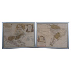
Antique framed black and white map of seven Midwestern American states. Guide Through Ohio, Michigan, Indiana, Illinois, Missouri, Wisconsin, & Iowa. Showing the Township Lines of the United States Surveys, Location of Cities, Towns, Villages, Post Hamlets, Canals, Rail and Stage Roads.
This striking cartographic map of the area known today as the Midwest was issued by John Calvin Smith and published by J.H. Colton in New York. It was tipped into the back of a small travel guide titled “The Western Tourist and Immigrants Guide,” also published by Colton and included with the map.
The map would have been a useful tool for the myriad of European immigrants who were moving to the United States in vast numbers throughout the mid-19th century. The states of Illinois, Indiana, Michigan, Ohio, Wisconsin, Iowa and Missouri are all displayed, with their respective transportation routes in the forms of railroads, canals and roads a focal point of the image. Distribution of surveyed counties and townships reflect the general pattern of westward settlement along these routes. Distance tables on the right side show various lengths of routes between popular destinations via water and land, while a decorative view at the bottom shows Maiden’s Rock on the tranquil Mississippi. The map provides a fascinating glimpse at how the U.S. promoted itself during the rush of immigration in the 19th century. Colton published several updated editions of this map through the late 1860’s.
Dimensions:
26.5” x 0.5” x 21” / Sans Frame - 25” x 19.5” (Width x Depth x Height)
- Creator:J.H. Colton (Manufacturer)
- Dimensions:Height: 21 in (53.34 cm)Width: 26.5 in (67.31 cm)Depth: 0.5 in (1.27 cm)
- Materials and Techniques:
- Period:
- Date of Manufacture:1844
- Condition:Wear consistent with age and use. Gentle wear to frame; Some discoloration to map.
- Seller Location:Dayton, OH
- Reference Number:Seller: 383661stDibs: LU5343234893342

About the Seller
5.0
Platinum Seller
Premium sellers with a 4.7+ rating and 24-hour response times
Established in 2010
1stDibs seller since 2020
1,641 sales on 1stDibs
Typical response time: <1 hour
- ShippingRetrieving quote...Shipping from: Dayton, OH
- Return Policy
Authenticity Guarantee
In the unlikely event there’s an issue with an item’s authenticity, contact us within 1 year for a full refund. DetailsMoney-Back Guarantee
If your item is not as described, is damaged in transit, or does not arrive, contact us within 7 days for a full refund. Details24-Hour Cancellation
You have a 24-hour grace period in which to reconsider your purchase, with no questions asked.Vetted Professional Sellers
Our world-class sellers must adhere to strict standards for service and quality, maintaining the integrity of our listings.Price-Match Guarantee
If you find that a seller listed the same item for a lower price elsewhere, we’ll match it.Trusted Global Delivery
Our best-in-class carrier network provides specialized shipping options worldwide, including custom delivery.More From This Seller
View All18th Century Antique Conrad Lotter Septentrionalis Meridionalis American Maps
Located in Dayton, OH
Pair of rare hand colored maps from the 1770's, depicting "America Septentrionalis" (North America), engraved by Georg Friedrich Lotter and America Meridionalis (South America), engr...
Category
Antique 18th Century Maps
Materials
Paper
$2,400 Sale Price
20% Off
Vintage Oversized New York City Lower Manhattan 1840s Map Print
Located in Dayton, OH
Vintage late 20th century reproduction print of New York City featuring lower Manhattan in 1840.
Category
Late 20th Century Victorian Maps
Materials
Paper

$800 Sale Price
20% Off
Antique Colored Belgium Map Flandria Gallica Flanders Henricus Hondius
Located in Dayton, OH
Antique hand colored map of Flanders, Belgium, engraved by Henricus Hondius.
Sans frame - 21.25” x 18”.
Category
Antique 19th Century Renaissance Maps
Materials
Paper

$280 Sale Price
20% Off
Antique Chicago Illinois National Map Commercial Rollup Classroom Census Map 47"
Located in Dayton, OH
Antique early to mid 20th century double sided hanging map titled the New Commercial and Census Map of Illinois, Edition 1073. Verso shows the National Map of Chicago and Suburbs - O...
Category
Early 20th Century North American Maps
Materials
Paper

$940 Sale Price
20% Off
Vincenzo Coronelli's Colored Map of the New World Western Hemisphere Framed 47"
By Vincenzo Coronelli
Located in Dayton, OH
A Framed Reproduction of Coronelli's Map of the New World, Attributed to Trevor James Company. The map shows the Western Hemisphere including the discoveries made by Abel Tasman in A...
Category
20th Century Maps
Materials
Paper

$1,080 Sale Price
20% Off
20th Century Large Vintage Oval Wall Map of the World Globe Conference Table 13'
Located in Dayton, OH
Monumental oval classroom map of the world / wall globe from the second half of the 20th century. A two piece sculpture design made with heavy wood and metal trim paneling. Can be ...
Category
20th Century Maps
Materials
Metal

$2,400 Sale Price
20% Off
You May Also Like
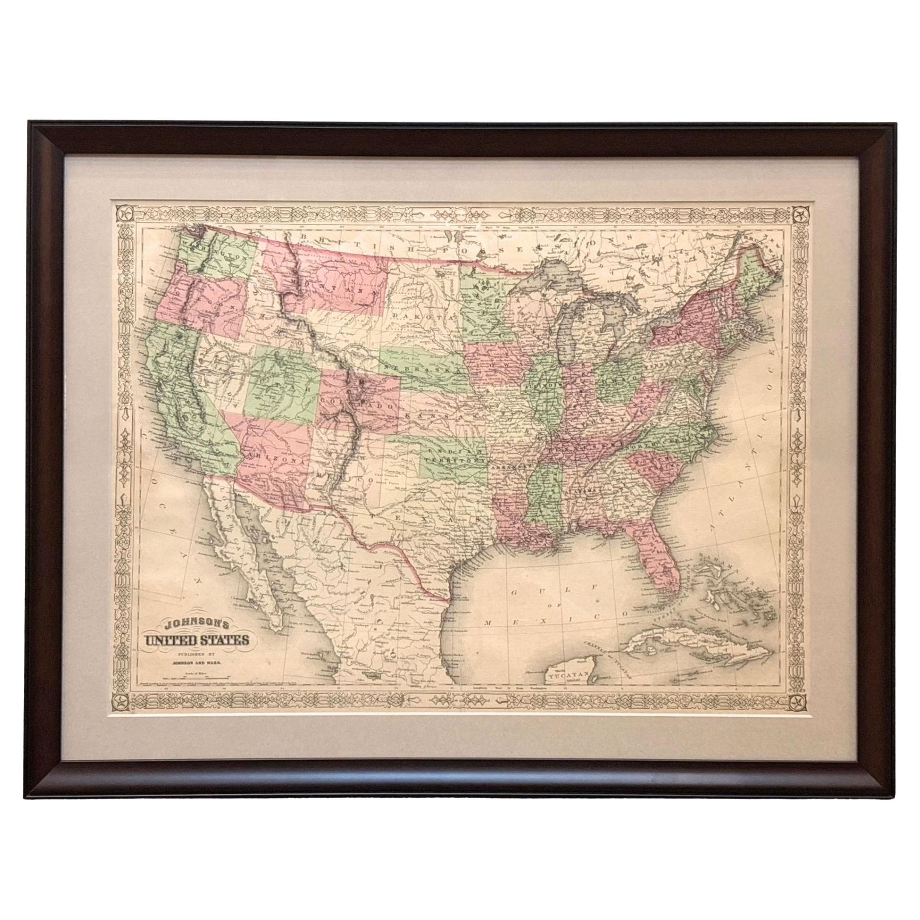
1866 "Johnson's United States" Map, Published by Johnson and Ward
Located in Colorado Springs, CO
Presented is a detailed map of the United States by A. J. Johnson. Spanning the whole of the continental United States, as well as adjacent parts of Canada and Mexico, the map reflec...
Category
Antique 1860s American Victorian Maps
Materials
Paper

1859 "Map of the United States of America..." by J. H. Colton
By J.H. Colton
Located in Colorado Springs, CO
Presented is an 1859 “Map of the United States of America, the British Provinces, Mexico, the West Indies and Central America with Part of...
Category
Antique 1850s American Maps
Materials
Paper

Antique Map of the United States by Balbi '1847'
Located in Langweer, NL
Antique map titled 'Etats-Unis'. Original antique map of the United States. This map originates from 'Abrégé de Géographie (..)' by Ad...
Category
Antique Mid-19th Century Maps
Materials
Paper

$191 Sale Price
20% Off
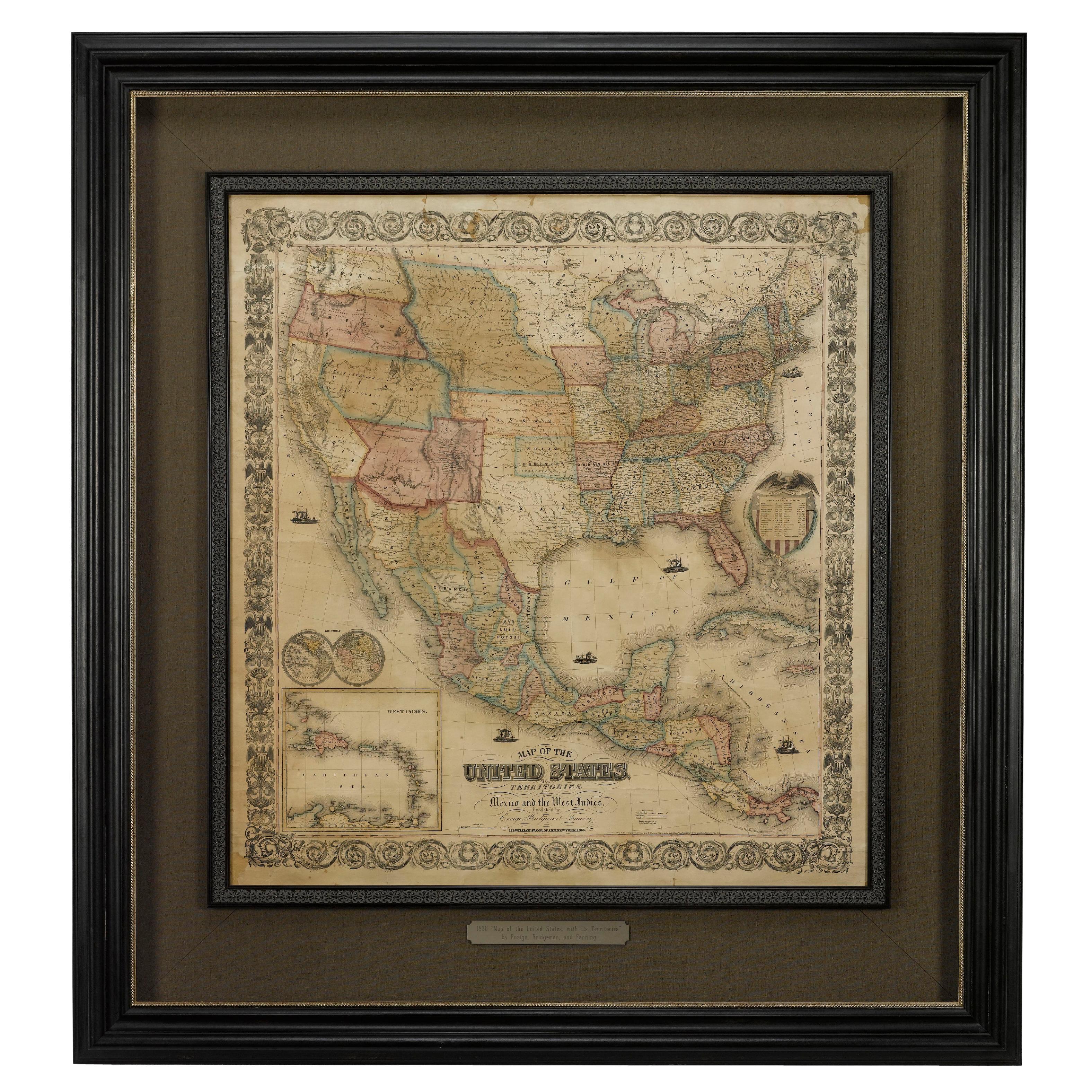
1856 "Map of the United States" by Ensign, Bridgeman, and Fanning
Located in Colorado Springs, CO
Presented is a scarce American wall map of the United States and Mexico issued by Ensign, Bridgman, and Fanning in 1856. As the title suggests, the map covers all of the United State...
Category
Antique 1850s American Victorian Maps
Materials
Paper

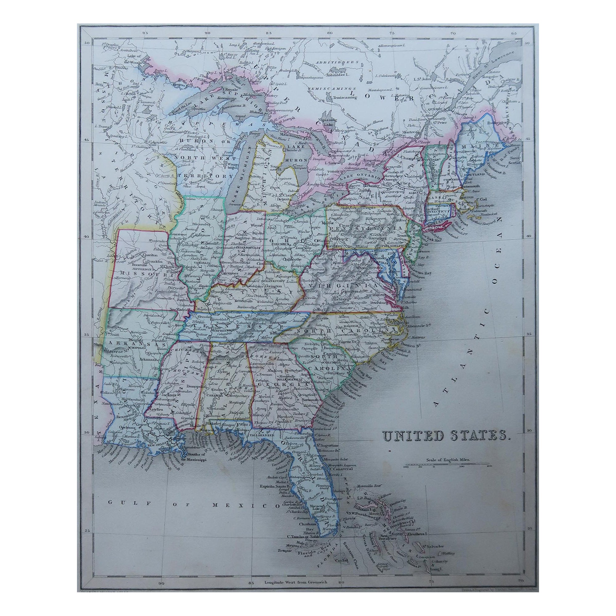
Original Antique Map of United States, Grattan and Gilbert, 1843
Located in St Annes, Lancashire
Great map of United States
Drawn and engraved by Archer
Published by Grattan and Gilbert. 1843
Original colour
Unframed.
Category
Antique 1840s English Maps
Materials
Paper

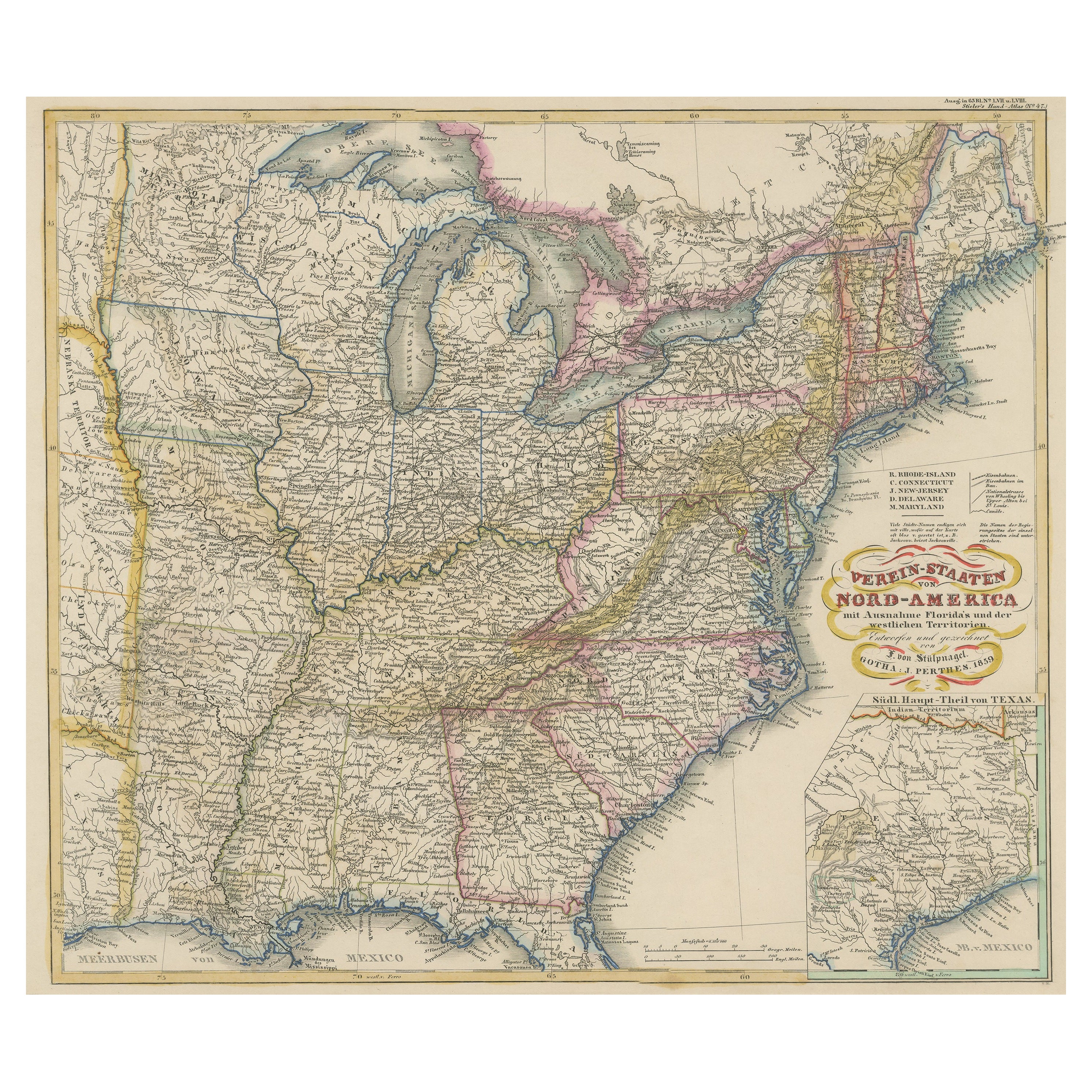
Antique Map of the Eastern United States with Inset Map of Texas
Located in Langweer, NL
Antique map titled 'Verein-Staaten von Nord-America mit Ausnahme Florida's und der Westlichen Territorien'. This map extends as far west as Louisiana and only includes the northern p...
Category
Antique Mid-19th Century Maps
Materials
Paper

$517 Sale Price
20% Off
More Ways To Browse
Vintage Long Island Map
Vintage World Map Desk
Vintage World Map Mirror
Antique Furniture Toledo Ohio
Antique Maps Washington Dc
Blaeu World Map
Cape Cod Map
F Colton
Irish Antiques 16th Century
Ithaca Antique Map
Leonard Jones
Russia Globe
Salt Lake City Used Furniture
World Map Copper
Luxury Modern Carpet
French Directoire Furniture
French Earthenware
Green French Glass