Items Similar to Antique Map of the Bay and Rocks of Petatlan by Anson, 1749


Want more images or videos?
Request additional images or videos from the seller
1 of 5
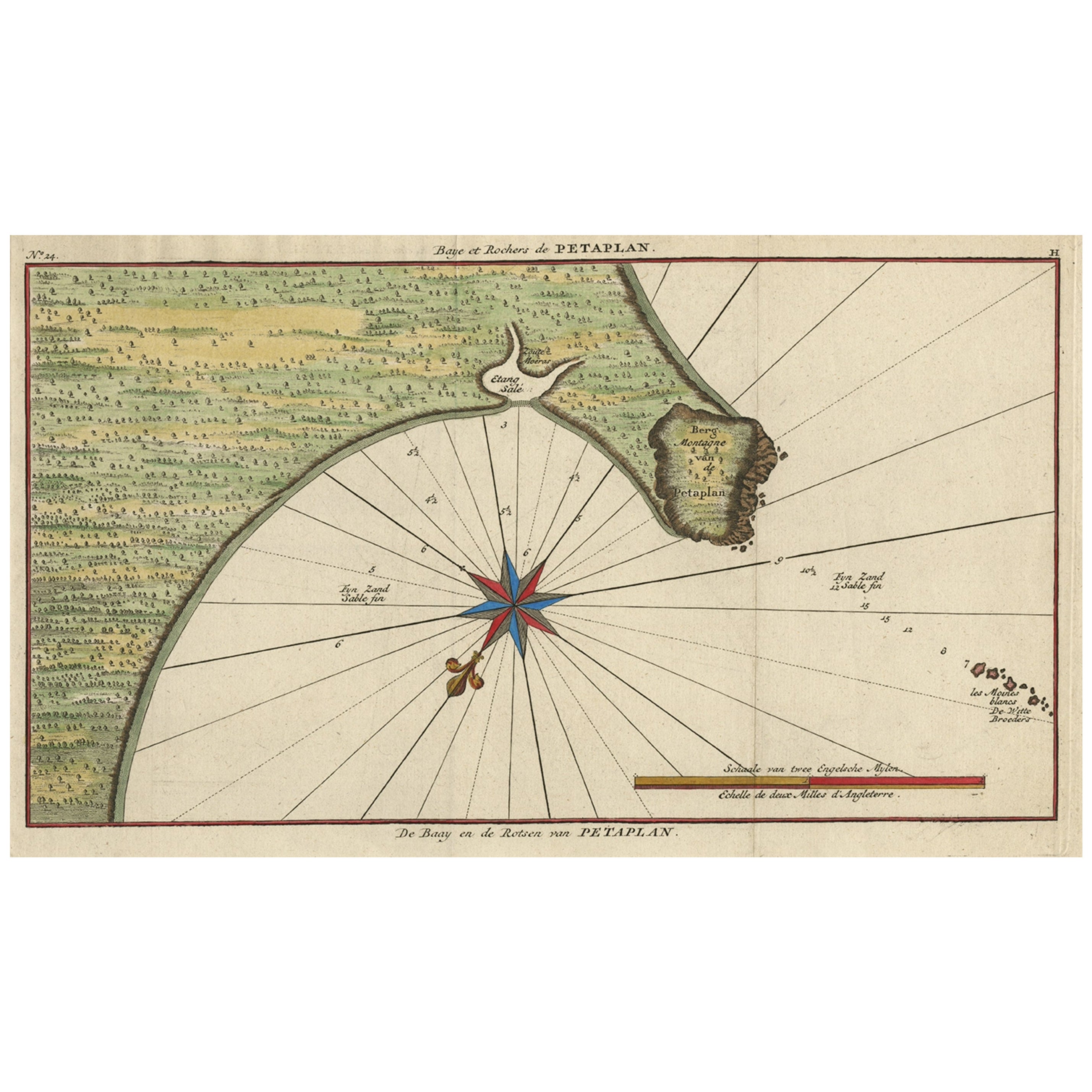
Antique Map of the Bay and Rocks of Petatlan by Anson, 1749
$153.08
$191.3620% Off
£112.93
£141.1720% Off
€128
€16020% Off
CA$211.92
CA$264.9020% Off
A$229.78
A$287.2320% Off
CHF 121.94
CHF 152.4320% Off
MX$2,830.08
MX$3,537.6020% Off
NOK 1,511.41
NOK 1,889.2720% Off
SEK 1,426.43
SEK 1,783.0420% Off
DKK 974.53
DKK 1,218.1720% Off
About the Item
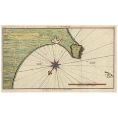
Antique map titled 'Baye et Rochers de Petaplan (..) - De Baay en de Rotsen van Petaplan (..)'. Original antique map of the bay and rocks of Petatlan, Mexico. This map originates from 'Reize rondsom de Werreld (..)' by George Anson, published 1749. Artists and Engravers: Admiral of the Fleet George Anson, 1st Baron Anson, PC, FRS (23 April 1697 ? 6 June 1762) was a Royal Navy officer.
Artist: Admiral of the Fleet George Anson, 1st Baron Anson, PC, FRS (23 April 1697 ? 6 June 1762) was a Royal Navy officer.
Antique prints have long been appreciated for both their aesthetic and investment value. They were the product of engraved, etched or lithographed plates. These plates were handmade out of wood or metal, which required an incredible level of skill, patience and craftsmanship. Whether you have a house with Victorian furniture or more contemporary decor an old engraving can enhance your living space. We offer a wide range of authentic antique prints for any budget.
- Dimensions:Height: 10.63 in (27 cm)Width: 16.54 in (42 cm)Depth: 0 in (0.01 mm)
- Materials and Techniques:
- Period:
- Date of Manufacture:1749
- Condition:Condition: Good, general age-related toning. Original folding lines. Minor wear, some foxing. Blank verso, please study image carefully.
- Seller Location:Langweer, NL
- Reference Number:Seller: BG-11589-121stDibs: LU3054327774612
About the Seller
5.0
Recognized Seller
These prestigious sellers are industry leaders and represent the highest echelon for item quality and design.
Platinum Seller
Premium sellers with a 4.7+ rating and 24-hour response times
Established in 2009
1stDibs seller since 2017
2,622 sales on 1stDibs
Typical response time: <1 hour
- ShippingRetrieving quote...Shipping from: Langweer, Netherlands
- Return Policy
Authenticity Guarantee
In the unlikely event there’s an issue with an item’s authenticity, contact us within 1 year for a full refund. DetailsMoney-Back Guarantee
If your item is not as described, is damaged in transit, or does not arrive, contact us within 7 days for a full refund. Details24-Hour Cancellation
You have a 24-hour grace period in which to reconsider your purchase, with no questions asked.Vetted Professional Sellers
Our world-class sellers must adhere to strict standards for service and quality, maintaining the integrity of our listings.Price-Match Guarantee
If you find that a seller listed the same item for a lower price elsewhere, we’ll match it.Trusted Global Delivery
Our best-in-class carrier network provides specialized shipping options worldwide, including custom delivery.More From This Seller
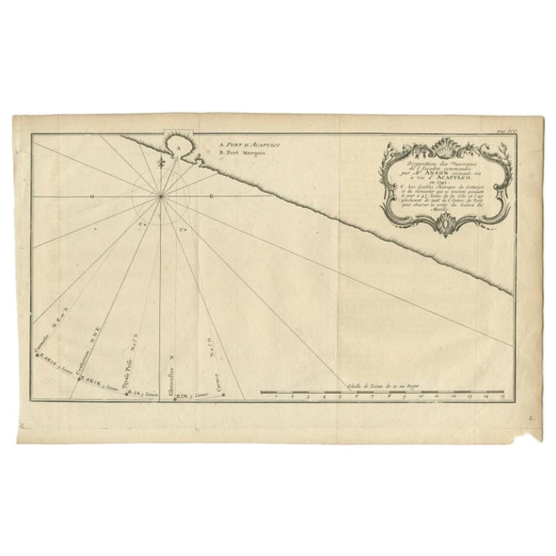
View AllAntique Map of the Coast of Acapulco by Anson, c.1740
Located in Langweer, NL
Antique map titled 'Disposition des Vaisseaux de l'Escadre commandée par Mr. Anson croisant vis à vis d'Acapulco en 1742'. This map depicts the coast of Acapulco in Mexico with a decorative cartouche and windrose. Acapulco and its port were important to the Mission of Commodore George Anson, who captured a Spanish treasure...
Category
Antique 18th Century Maps
Materials
Paper
Antique Map of Juan Fernandez Island by Anson, c.1740
Located in Langweer, NL
Antique map titled 'Plan de la Côte du N.E. de l 'Ile de Juan Fernandes'.
Map of the northeast coast of the island of Juan Fernandez with Cumberland Bay, South America. In 1740 Ans...
Category
Antique 18th Century Maps
Materials
Paper

$229 Sale Price
20% Off
Antique Map of the Coast of Juan Fernandez by Van Schley, 1757
Located in Langweer, NL
Antique map titled 'Cote du Nord Est de l'Isle de Juan Fernandez (..).' Map of the Chilean South Pacific archipelago of the Juan Fernandez Islands. This island was made famous by Dan...
Category
Antique 18th Century Maps
Materials
Paper

$136 Sale Price
20% Off
Antique Map of Juan Fernandez Island and Cumberland Bay, Chile - c. '1749'
Located in Langweer, NL
Antique map titled 'Plan de la Côte du N.E. de l 'Ile de Juan Fernandes - Schets van den Noord-Oost kant van het eiland Juan Fernandes '. This map depicts the northeast coast of the ...
Category
Antique Mid-18th Century Maps
Materials
Paper

$191 Sale Price
20% Off
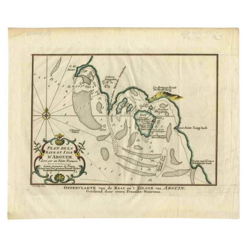
Antique Map of the Bay and Island of Arguin by Van Schley, 1747
Located in Langweer, NL
Antique map titled ?Plan de la Baye et Isle d'Arguim (..) - Oppervlakte van de Baai en 't Eiland van Arguin (..)'. Original antique map of the bay and the island of Arguin. This map ...
Category
Antique 18th Century Maps
Materials
Paper

$93 Sale Price
20% Off
Original Antique Map of the Bay and Rocks of Petatlan, Mexico, 1749
Located in Langweer, NL
Antique map titled 'Baye et Rochers de Petaplan (..) - De Baay en de Rotsen van Petaplan (..)'.
Original antique map of the bay and rocks of Petatlan, Mexico. This map originates...
Category
Antique 1740s Maps
Materials
Paper
$344 Sale Price
20% Off
You May Also Like
Original Antique Map of South America. C.1780
Located in St Annes, Lancashire
Great map of South America
Copper-plate engraving
Published C.1780
Two small worm holes to left side of map
Unframed.
Category
Antique Early 1800s English Georgian Maps
Materials
Paper

Original Antique Map of The World by Thomas Clerk, 1817
Located in St Annes, Lancashire
Great map of The Eastern and Western Hemispheres
On 2 sheets
Copper-plate engraving
Drawn and engraved by Thomas Clerk, Edinburgh.
Published by Mackenzie And Dent, 1817
...
Category
Antique 1810s English Maps
Materials
Paper

Antique Map of California as an Island "The 5 Californias" by Robert de Vaugondy
Located in San Diego, CA
A very nice and rare antique map entitled "Carte de la Californie Suivant" (The 5 Californias), by Didier Robert de Vaugondy of Paris, circa 1772. The map itself measures 15.5" x 13...
Category
Antique Mid-19th Century American Maps
Materials
Paper

Antique Map - Mare Pacificum - Etching by Johannes Janssonius - 1650s
By Johannes Janssonius
Located in Roma, IT
Mare Pacificum is an antique map realized in 1650 by Johannes Janssonius (1588-1664).
The Map is Hand-colored etching, with coeval watercolorang.
Good conditions with slight foxing...
Category
1650s Modern Figurative Prints
Materials
Etching

Antique Lithography Map, West Africa, English, Framed, Cartography, Victorian
Located in Hele, Devon, GB
This is an antique lithography map of Western Africa. An English, framed atlas engraving of cartographic interest by John Rapkin, dating to the early Victorian period and later, circ...
Category
Antique Mid-19th Century British Early Victorian Maps
Materials
Wood

Large Original Antique Map of The Canary Islands. 1894
Located in St Annes, Lancashire
Superb Antique map of The Canary Islands
Published Edward Stanford, Charing Cross, London 1894
Original colour
Good condition
Unframed.
Free shipping
Category
Antique 1890s English Maps
Materials
Paper
