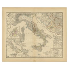
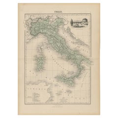
Antique Map of Italy with Insets of Rome and Major Cities, Published in 1880
View Similar Items


Want more images or videos?
Request additional images or videos from the seller
1 of 8
Auction endedBrowse Current Auctions
Antique Map of Italy with Insets of Rome and Major Cities, Published in 1880
About the Item
- Dimensions:Height: 15.56 in (39.5 cm)Width: 18.51 in (47 cm)Depth: 0 in (0.02 mm)
- Materials and Techniques:
- Period:
- Date of Manufacture:1880
- Condition:Good, given age. General age-related toning, especially around the edges. The vertical folding line as issued. Please study scan carefully.
- Seller Location:Langweer, NL
- Reference Number:Seller: BG-13686-2-291stDibs: LU3054338558142
About the Seller
5.0
Platinum Seller
These expertly vetted sellers are 1stDibs' most experienced sellers and are rated highest by our customers.
Established in 2009
1stDibs seller since 2017
1,928 sales on 1stDibs
More From This SellerView All
- Antique Map of Italy with an Inset of Rome, 1812Located in Langweer, NLAntique map titled 'Italie Ancienne'. Old map of ancient Italy, with an inset map of the region of Rome. This map originates from 'Atlas Supplementaire du Precis de la Geographie...Category
Antique 19th Century Maps
MaterialsPaper
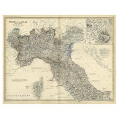
- Antique Map of Italy with Vignette of Saint Angu Castle in Rome, 1880Located in Langweer, NLAntique map titled 'Italie Septentrionale'. Old map of Italy with a decorative vignette of Saint Angu castle in Rome. This map originates from 'G...Category
Antique 19th Century Maps
MaterialsPaper
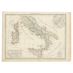
- Ancient Italy: Regions and Rome in the Roman Empire, Published in 1880Located in Langweer, NLThis print is an original detailed map titled "ITALIAE REGIONES I VII VIII IX XI," representing the regions of ancient Italy. Key Features of the Print: 1. **Regional Demarcations...Category
Antique 1880s Maps
MaterialsPaper
- Antique Map of the United States with inset map of the region of Mexico CityLocated in Langweer, NLAntique map titled 'Verein-Staaten von Nord-America, Mexico, Yucatan u.a.'. Very detailed map of the United States of America showing the Caribbean. With an inset map of the surround...Category
Antique Mid-19th Century Maps
MaterialsPaper
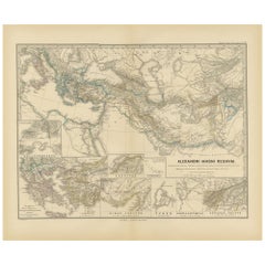
- Antique Map of The Kingdom of Alexander the Great, Published in 1880Located in Langweer, NLThe map is titled "ALEXANDRI MAGNI REGNUM," which translates to "The Kingdom of Alexander the Great." It depicts the vast territories conquered by Alexander the Great during his reig...Category
Antique 1880s Maps
MaterialsPaper
- Old Coloure Map of North & Central Italy & Corsica with an Inset of Rome, c.1860Located in Langweer, NLAntique map titled 'North & Central Italy and the Island of Corsica'. Old map of North and Central Italy, and the island of Corsica. With an inset map of the region of Rome. Orig...Category
Antique 1860s Maps
MaterialsPaper


You May Also Like
- 1840 Map of the City of Washington Published by William M. MorrisonLocated in Colorado Springs, COThis map, printed in 1840, is a detailed representation of Washington, D.C. in the mid-19th century. The map shows block numbers, wards, and government buildings as well as details o...Category
Antique 1840s American Federal Maps
MaterialsPaper
- Antique Oarsman's Map of the River Thames, English, Cartography, Published 1912Located in Hele, Devon, GBThis is an antique copy of The Oarsman's and Angler's Map of the River Thames - New Edition. An English, bound map book, published in English by Edward Stanford, London, this new edi...Category
Early 20th Century British Other Books
MaterialsPaper
- Italian Parchment Map of the City of Lucca Dated 1640By Matthäus Merian the ElderLocated in Roma, ITAn antique map of the Tuscan city of Lucca engraved for The 'Itinerarium Italiæ Nov-antiquæ' by Matthäus Merian the Elder and printed in 1640...Category
Antique 1640s Italian Maps
MaterialsParchment Paper, Paper
- Italian Parchment Map of the City of Pisa Dated, 1640By Matthäus Merian the ElderLocated in Roma, ITAn antique map of the Tuscan city of Pisa engraved for The 'Itinerarium Italiæ Nov-antiquæ' by Matthäus Merian the Elder and printed in 1640....Category
Antique 1640s Italian Maps
MaterialsPaper
- London 1744 Published Watercolour Antique Map of East Africa by Eman BowenLocated in GBWe are delighted to offer for sale this New and Accurate Map of Nubia & Abissinia, together with all the Kingdoms Tributary Thereto, and bordering upon them published in 1744 by Emanuel Bowen This is a decorative antique engraved map of East Africa...Category
Antique 1740s English George III Maps
MaterialsPaper
- Antique Paterson's Guide to Britain, English, Maps, Georgian, Published 1811Located in Hele, Devon, GBThis is an antique copy of Paterson's New and Accurate guide to Direct & Principal Crossroads. An English, bound book of maps and descriptive tables, published in English by Longman,...Category
Antique Early 19th Century British Georgian Books
MaterialsPaper


