Items Similar to Antique Map of Overijssel by Visscher, 1632
Want more images or videos?
Request additional images or videos from the seller
1 of 5
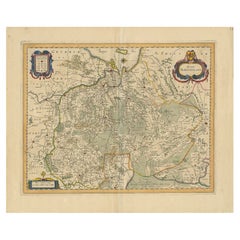
Antique Map of Overijssel by Visscher, 1632
$490.68
$613.3520% Off
£363.25
£454.0620% Off
€410.40
€51320% Off
CA$678.98
CA$848.7220% Off
A$748.56
A$935.7020% Off
CHF 391.62
CHF 489.5320% Off
MX$9,183.43
MX$11,479.2920% Off
NOK 4,929.75
NOK 6,162.1820% Off
SEK 4,610.09
SEK 5,762.6120% Off
DKK 3,126.18
DKK 3,907.7220% Off
About the Item
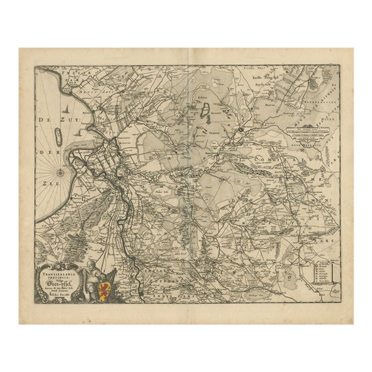
Antique map titled 'De Heerlyckheyt van Over-IJssel'. Old map of the province of Overijssel, the Netherlands. Also depicted are various coats of arms. Artists and Engravers: Engraved by A. Goos, published by C.J. Visscher. laes Janszoon Visscher (1587 ? 19 June 1652) was a Dutch Golden Age draughtsman, engraver, mapmaker and publisher. He was also known as Nicolas Joannes Piscator.
Artist: Engraved by A. Goos, published by C.J. Visscher. laes Janszoon Visscher (1587 ? 19 June 1652) was a Dutch Golden Age draughtsman, engraver, mapmaker and publisher. He was also known as Nicolas Joannes Piscator.
Condition: Fair, general age-related toning and some foxing. Minor tears and defects, repair on folding line. Please study image carefully.
Date: 1632
Overall size: 55.5 x 47 cm.
Image size: 0.001 x 50.5 x 39 cm.
Antique prints have long been appreciated for both their aesthetic and investment value. They were the product of engraved, etched or lithographed plates. These plates were handmade out of wood or metal, which required an incredible level of skill, patience and craftsmanship. Whether you have a house with Victorian furniture or more contemporary decor an old engraving can enhance your living space. We offer a wide range of authentic antique prints for any budget.
- Dimensions:Height: 18.51 in (47 cm)Width: 21.86 in (55.5 cm)Depth: 0 in (0.01 mm)
- Materials and Techniques:
- Period:
- Date of Manufacture:1632
- Condition:
- Seller Location:Langweer, NL
- Reference Number:Seller: BG-11880-11stDibs: LU3054327618062
About the Seller
5.0
Recognized Seller
These prestigious sellers are industry leaders and represent the highest echelon for item quality and design.
Platinum Seller
Premium sellers with a 4.7+ rating and 24-hour response times
Established in 2009
1stDibs seller since 2017
2,609 sales on 1stDibs
Typical response time: <1 hour
- ShippingRetrieving quote...Shipping from: Langweer, Netherlands
- Return Policy
Authenticity Guarantee
In the unlikely event there’s an issue with an item’s authenticity, contact us within 1 year for a full refund. DetailsMoney-Back Guarantee
If your item is not as described, is damaged in transit, or does not arrive, contact us within 7 days for a full refund. Details24-Hour Cancellation
You have a 24-hour grace period in which to reconsider your purchase, with no questions asked.Vetted Professional Sellers
Our world-class sellers must adhere to strict standards for service and quality, maintaining the integrity of our listings.Price-Match Guarantee
If you find that a seller listed the same item for a lower price elsewhere, we’ll match it.Trusted Global Delivery
Our best-in-class carrier network provides specialized shipping options worldwide, including custom delivery.More From This Seller
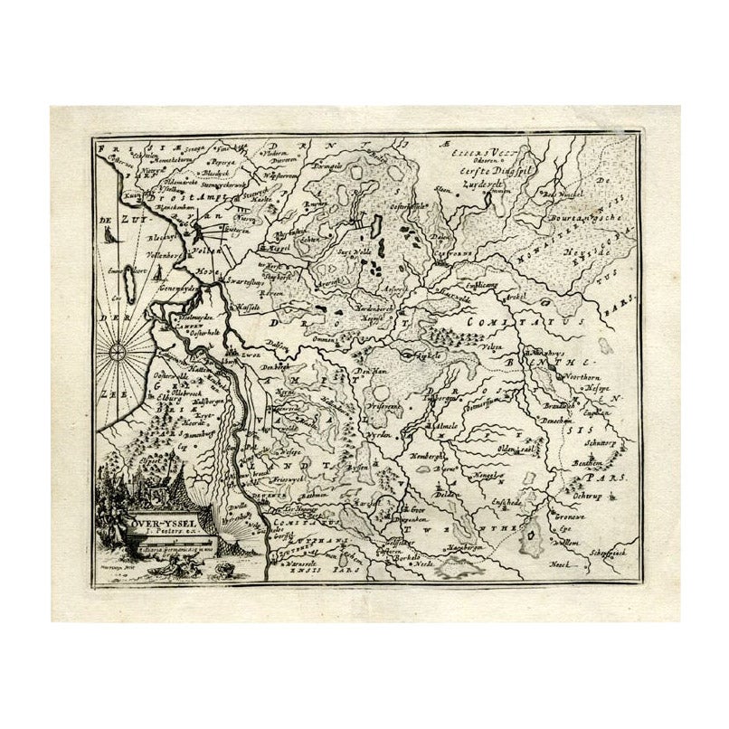
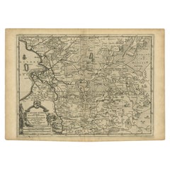
View AllAntique Map of Overijssel by Visscher, c.1652
Located in Langweer, NL
Antique map titled 'Transisalania provincia vulgo Over-yssel'. Original antique map of the province of Overijssel, the Netherlands. Published by N. Visscher after N. ten Have, circa ...
Category
Antique 17th Century Maps
Materials
Paper
$524 Sale Price
20% Off
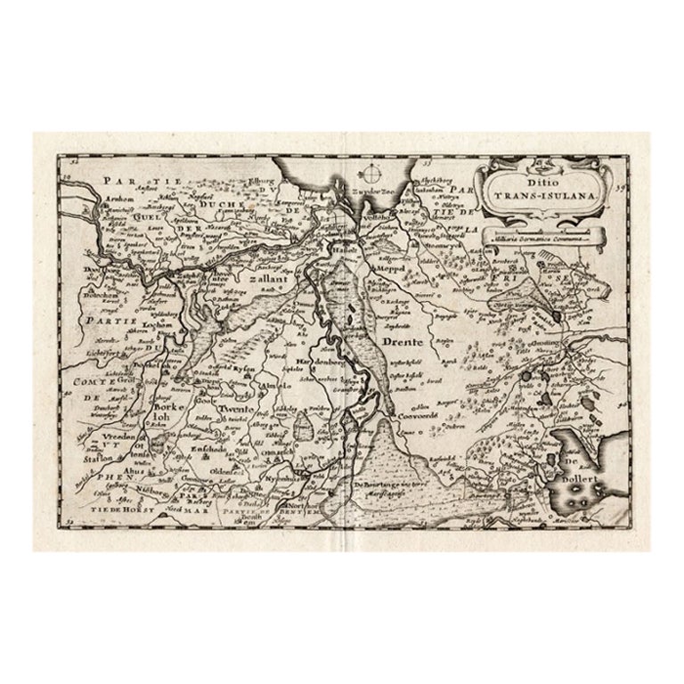
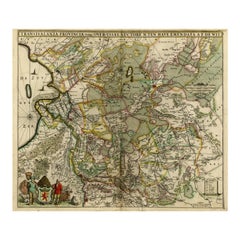
Antique Map of Overijssel by Colom, 1635
Located in Langweer, NL
Antique map titled 'Ditio Trans-Isulana'. Original antique map of the province of Overijssel, the Netherlands. This map originates from 'Vyerige Colom verthonende de 17 Nederlandsche...
Category
Antique 17th Century Maps
Materials
Paper
$210 Sale Price
20% Off
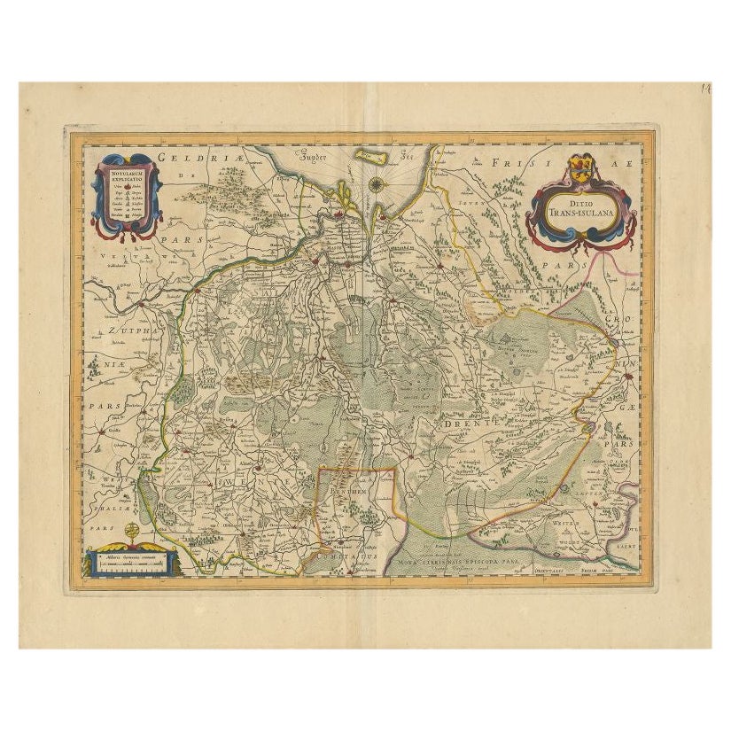
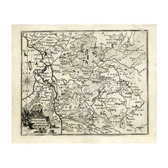
Antique Map of the Province of Overijssel by Janssonius, c.1650
Located in Langweer, NL
Antique map titled 'Ditio Trans-isulana'. Original antique map of the province of Overijssel, the Netherlands. With coat of arms and two decorative cartouches. Published by J. Jansso...
Category
Antique 17th Century Maps
Materials
Paper
$497 Sale Price
20% Off
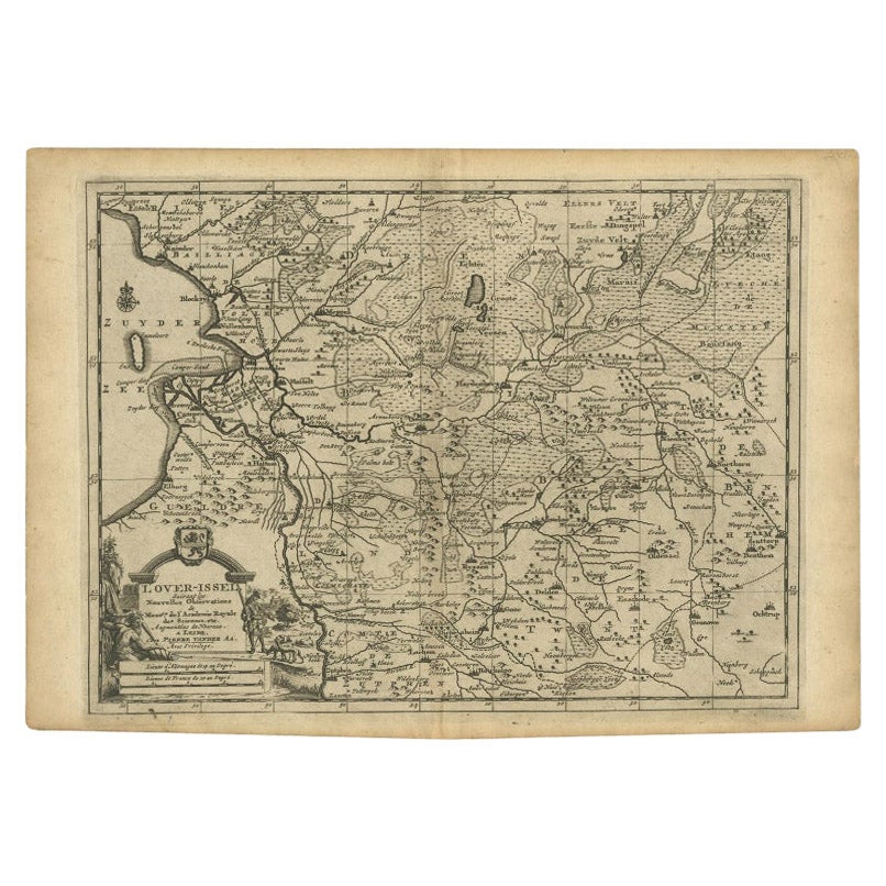
Antique Map of Overijssel by Van der Aa, c.1715
Located in Langweer, NL
Antique map titled 'L'Over-Issel'. This map depicts the Dutch province Overijssel. This map originates from 'Nouvel Atlas, très exact et fort commode pour toutes sortes de personnes,...
Category
Antique 18th Century Maps
Materials
Paper
$181 Sale Price
20% Off
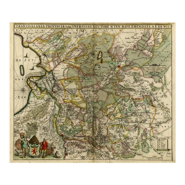
Antique Map of Overijssel by De Wit, c.1680
Located in Langweer, NL
Antique map titled 'Transisalania Provincia Vulgo Over-Yssel'. Original antique map of Overijssel, the Netherlands, showing the regio between Zutphen, Zwolle, Blokzijl, Coevorden, Ol...
Category
Antique 17th Century Maps
Materials
Paper
$425 Sale Price
20% Off
Antique Map of Overijssel by Bachiene, 1758
Located in Langweer, NL
Antique map titled 'Over-Yssel'. Map of the Overijssel, the Netherlands. This map originates from 'Kort begrip der Oude en Nieuwe Staatkundige Geographie', by W.A. Bachiene, publishe...
Category
Antique 18th Century Maps
Materials
Paper
$162 Sale Price
20% Off
You May Also Like
1646 Jansson Map Entitled "Procinvia Connactiae, " Ric.a006
Located in Norton, MA
1646 Jansson map entitled
"Procinvia connactiae,"
Ric.a006
Description: The PROVINCE of CONNAVGT 490 x 380From vol 4 of Jansson's Atlas Novus 1646, published in Amsterdam with...
Category
Antique 17th Century Unknown Maps
Materials
Paper

1657 Janssonius Map of Vermandois and Cappelle, Ric. A-004
Located in Norton, MA
1657 Janssonius map of
Vermandois and Cappelle
Ric.a004
Description: Antique map of France titled 'Descriptio Veromanduorum - Gouvernement de la Cappelle'. Two detailed maps o...
Category
Antique 17th Century Unknown Maps
Materials
Paper

1635 Willem Blaeu Map of Northern France"Comitatvs Bellovacvm" Ric.a08
Located in Norton, MA
1635 Willem Blaeu map of northern France, entitled.
"Comitatvs Bellovacvm Vernacule Beavvais,"
Colored
Ric.a008
“COMITATVS BELLOVACVM…” Amsterdam: W...
Category
Antique 17th Century Unknown Maps
Materials
Paper

Original Antique Map of Switzerland, Engraved By Barlow, Dated 1807
Located in St Annes, Lancashire
Great map of Switzerland
Copper-plate engraving by Barlow
Published by Brightly & Kinnersly, Bungay, Suffolk.
Dated 1807
Unframed.
Category
Antique Early 1800s English Maps
Materials
Paper

1620 Map of Artois Entitled "Artesia Comitatvs Artois, " by Bleau, Ric.a012
Located in Norton, MA
1640 map of Artois entitled
"Artesia Comitatvs Artois,"
by Bleau
Colored
A-012.
Detailed map of the northern province of Artois, France on the border with Belgium. Feature...
Category
Antique 17th Century Dutch Maps
Materials
Paper

1640 Willem Blaeu Map Entitled "Contado di molise et principato vltra, " Ric.a003
By Willem Blaeu
Located in Norton, MA
1640 Willem Blaeu map entitled
"Contado di molise et principato vltra,"
Colored
Ric. a003
Measures: 38 x 49.6 cm and wide margins
DBLAEU.
Cou...
Category
Antique 17th Century Dutch Maps
Materials
Paper

More Ways To Browse
Papua New Guinea Antique Map
Tennessee Antique Furniture
Used Office Furniture Maine
Ancient World Map
Antique Florida Map
Antique Geological Maps
Antique Map Chile
Antique Map Of Georgia
Antique Mississippi Furniture
Burgundy Map
Peninsular War
Taiwan Map
Used Furniture Alabama
Antique Chicago Maps
Dutch Bible
Thailand Map
Antique Dutch Bible
Antique Louisiana Map