Items Similar to Antique Map of the Province of Overijssel by Coronelli, c.1692

Want more images or videos?
Request additional images or videos from the seller
1 of 5
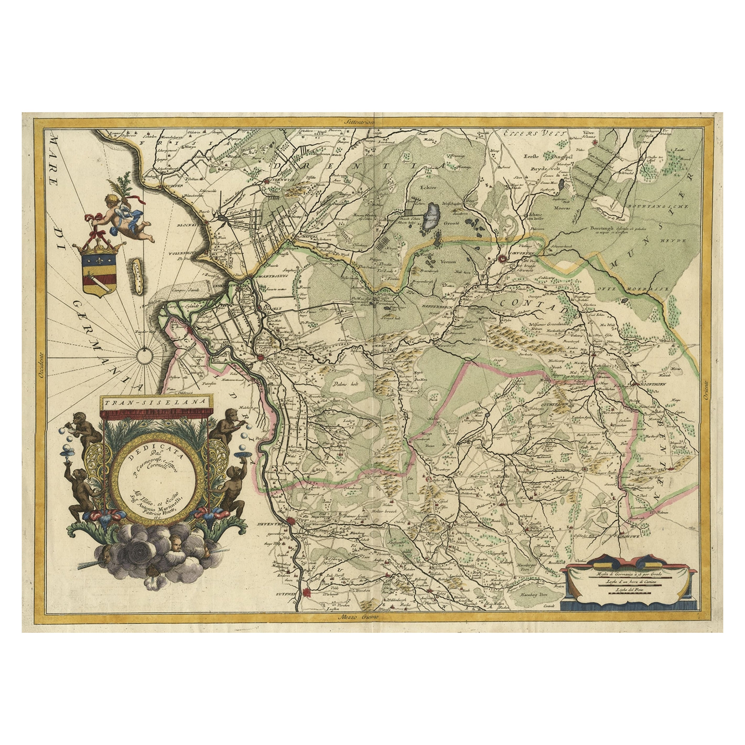
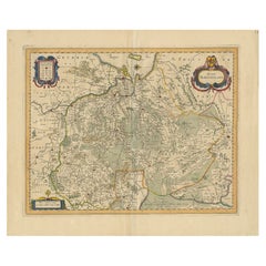
Antique Map of the Province of Overijssel by Coronelli, c.1692
$515.01
$643.7620% Off
£381.61
£477.0220% Off
€431.20
€53920% Off
CA$712.43
CA$890.5320% Off
A$785.14
A$981.4320% Off
CHF 411.05
CHF 513.8120% Off
MX$9,644.04
MX$12,055.0520% Off
NOK 5,164.91
NOK 6,456.1420% Off
SEK 4,833.95
SEK 6,042.4420% Off
DKK 3,283.91
DKK 4,104.8820% Off
About the Item
Antique map titled 'Tran-siselana' Splendid detailed and decorative map of the province of Overijssel in the Netherlands by Vincenzo Coronelli. An elaborate title cartouche garlanded with intertwined flowers and dedicated to Antonio Martinelli. Source unknown, to be determined.
Artists and Engravers: The remarkable Vincenzo Coronelli (1650-1718), encyclopaedist, geographer, inventor and Doctor of Theology, was citizen of the Republic of Venice. He was also one of the most prominent mapmakers and publishers in Europe of his day.
Condition: Good, general age-related toning. Few small tears and some wear. Please study image carefully.
Date: c.1692
Overall size: 68 x 48 cm.
Image size: 59.5 x 45 cm.
We sell original antique maps to collectors, historians, educators and interior decorators all over the world. Our collection includes a wide range of authentic antique maps from the 16th to the 20th centuries. Buying and collecting antique maps is a tradition that goes back hundreds of years. Antique maps have proved a richly rewarding investment over the past decade, thanks to a growing appreciation of their unique historical appeal. Today the decorative qualities of antique maps are widely recognized by interior designers who appreciate their beauty and design flexibility. Depending on the individual map, presentation, and context, a rare or antique map can be modern, traditional, abstract, figurative, serious or whimsical. We offer a wide range of authentic antique maps for any budget.
- Dimensions:Height: 18.9 in (48 cm)Width: 26.78 in (68 cm)Depth: 0 in (0.01 mm)
- Materials and Techniques:
- Period:
- Date of Manufacture:circa 1692
- Condition:
- Seller Location:Langweer, NL
- Reference Number:Seller: BGJC-002441stDibs: LU3054327827812
About the Seller
5.0
Recognized Seller
These prestigious sellers are industry leaders and represent the highest echelon for item quality and design.
Platinum Seller
Premium sellers with a 4.7+ rating and 24-hour response times
Established in 2009
1stDibs seller since 2017
2,615 sales on 1stDibs
Typical response time: <1 hour
- ShippingRetrieving quote...Shipping from: Langweer, Netherlands
- Return Policy
Authenticity Guarantee
In the unlikely event there’s an issue with an item’s authenticity, contact us within 1 year for a full refund. DetailsMoney-Back Guarantee
If your item is not as described, is damaged in transit, or does not arrive, contact us within 7 days for a full refund. Details24-Hour Cancellation
You have a 24-hour grace period in which to reconsider your purchase, with no questions asked.Vetted Professional Sellers
Our world-class sellers must adhere to strict standards for service and quality, maintaining the integrity of our listings.Price-Match Guarantee
If you find that a seller listed the same item for a lower price elsewhere, we’ll match it.Trusted Global Delivery
Our best-in-class carrier network provides specialized shipping options worldwide, including custom delivery.More From This Seller
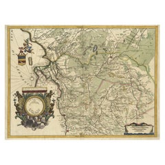
View AllAntique Map of the Province of Gelderland, the Netherlands, c.1690
Located in Langweer, NL
Antique map titled 'Ducatus Geldriae novissima descriptio'. Map of Gelderland, The Netherlands. Shows many cities (like Arnhem, Nijmegen, Eindhoven, Zutphen, Zwolle, etc), roads, riv...
Category
Antique 17th Century Maps
Materials
Paper

$477 Sale Price
20% Off
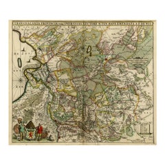
Splendid Detailed Map of the Province of Overijssel in the Netherlands, ca.1692
Located in Langweer, NL
Antique map titled 'Tran-siselana'. Splendid detailed and decorative map of the province of Overijssel in the Netherlands by Vincenzo Coronelli. An elaborate title cartouche garlande...
Category
Antique 1690s Maps
Materials
Paper
$1,460 Sale Price
24% Off
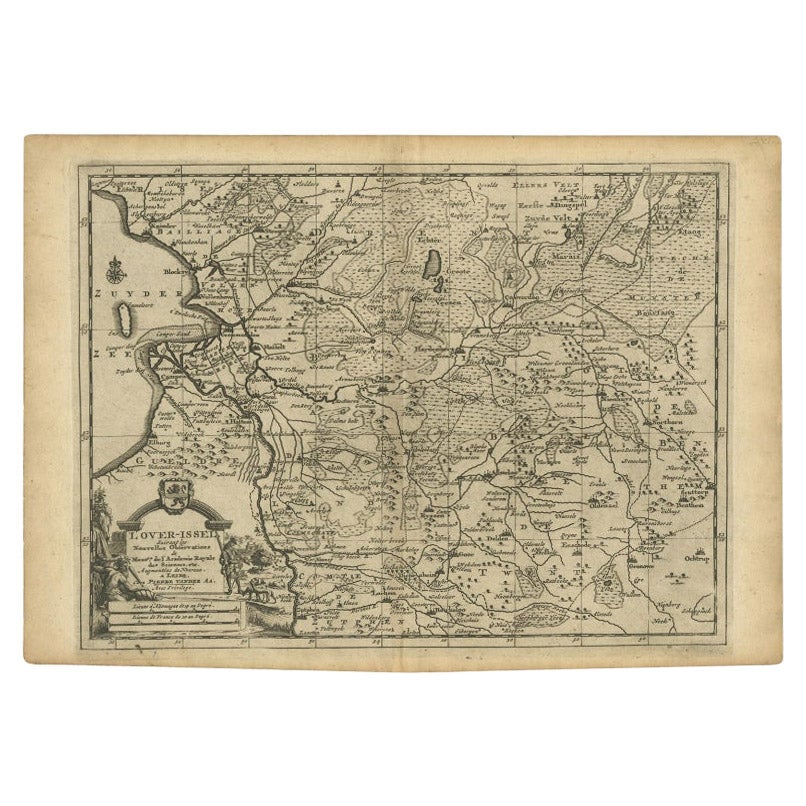
Antique Map of Overijssel by Van der Aa, c.1715
Located in Langweer, NL
Antique map titled 'L'Over-Issel'. This map depicts the Dutch province Overijssel. This map originates from 'Nouvel Atlas, très exact et fort commode pour toutes sortes de personnes,...
Category
Antique 18th Century Maps
Materials
Paper
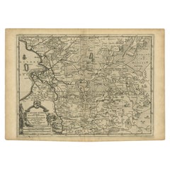
$181 Sale Price
20% Off
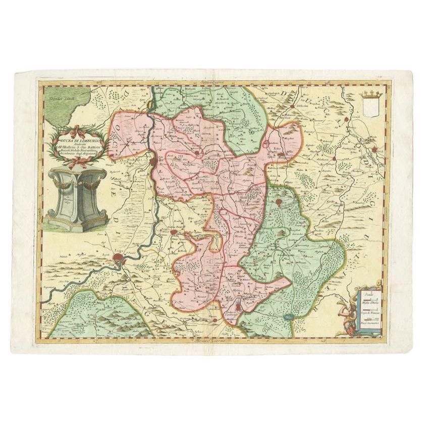
Antique Map of the Province of Limburg by Coronelli, 1692
Located in Langweer, NL
Antique map titled 'Ducea di Limburgo (..)'. Beautiful map of the Dutch province of Limburg. Originates from 'Corso Geographico Universale'.
Artists and Engravers: Published in Ven...
Category
Antique 17th Century Maps
Materials
Paper
$640 Sale Price
20% Off
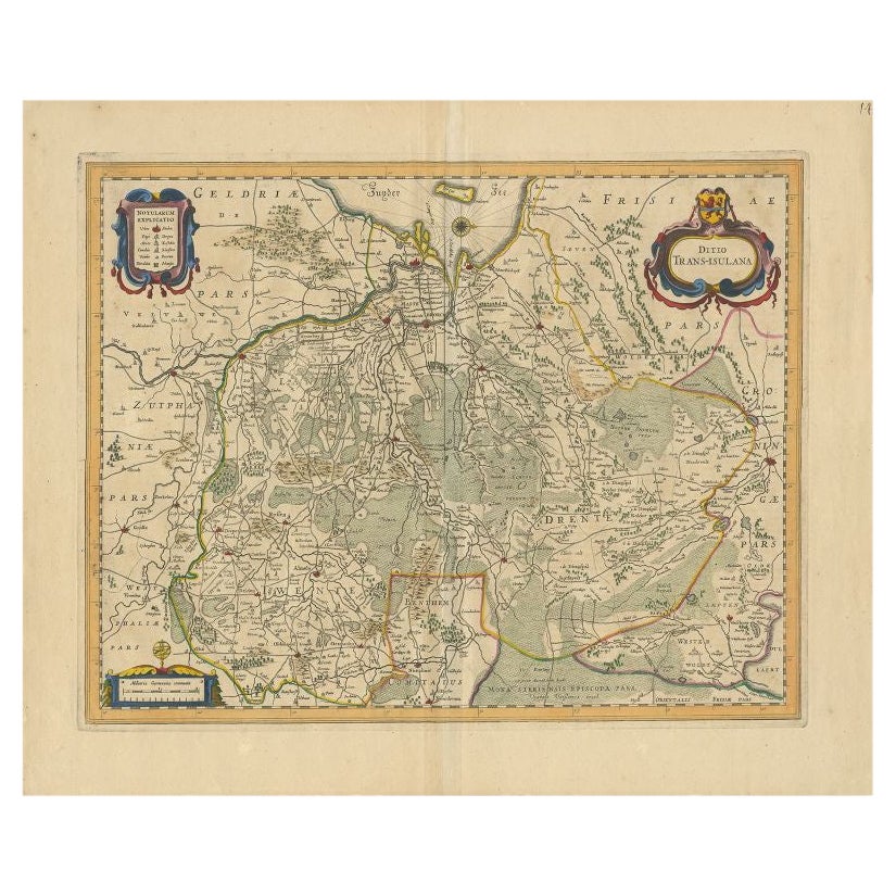
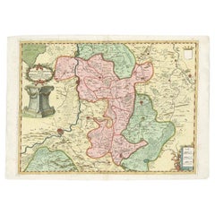
Antique Map of the Province of Overijssel by Janssonius, c.1650
Located in Langweer, NL
Antique map titled 'Ditio Trans-isulana'. Original antique map of the province of Overijssel, the Netherlands. With coat of arms and two decorative cartouches. Published by J. Jansso...
Category
Antique 17th Century Maps
Materials
Paper
$496 Sale Price
20% Off
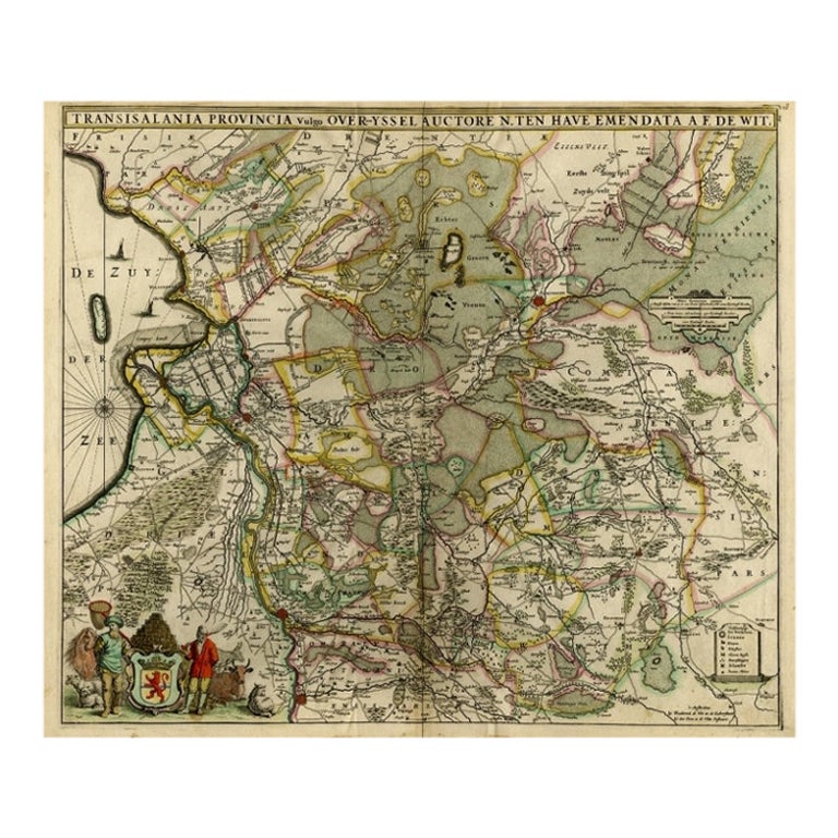
Antique Map of Overijssel by De Wit, c.1680
Located in Langweer, NL
Antique map titled 'Transisalania Provincia Vulgo Over-Yssel'. Original antique map of Overijssel, the Netherlands, showing the regio between Zutphen, Zwolle, Blokzijl, Coevorden, Ol...
Category
Antique 17th Century Maps
Materials
Paper
$425 Sale Price
20% Off
You May Also Like
18th Century Emanuel Bowen Map of County of York, c.1740
By Emanuel Bowen
Located in Royal Tunbridge Wells, Kent
Antique 18th century British rare and original Emanuel Bowen (1694-1767) map of the County of York divided into its Ridings and subdivided into wapontakes, mounted in solid wood fram...
Category
Antique Early 18th Century British Maps
Materials
Paper

1752 Vaugoundy Map of Flanders : Belgium, France, and the Netherlands, Ric.a002
Located in Norton, MA
Large Vaugoundy Map of Flanders:
Belgium, France, and the Netherlands
Colored -1752
Ric.a002
Description: This is a 1752 Didier Robert de Vaugondy map of Flanders. The map de...
Category
Antique 17th Century Unknown Maps
Materials
Paper

Antique County Map of Cheshire, Dutch, Framed, Cartography, Janssonius, C.1660
Located in Hele, Devon, GB
This is an antique county map of Cheshire. A Dutch, framed atlas engraving by Johannes Janssonius, dating to the 17th century and later.
A treat for the collector or county native,...
Category
Antique Mid-17th Century Dutch Charles II Maps
Materials
Glass, Wood, Paper

1635 Willem Blaeu Map of Northern France"Comitatvs Bellovacvm" Ric.a08
Located in Norton, MA
1635 Willem Blaeu map of northern France, entitled.
"Comitatvs Bellovacvm Vernacule Beavvais,"
Colored
Ric.a008
“COMITATVS BELLOVACVM…” Amsterdam: W...
Category
Antique 17th Century Unknown Maps
Materials
Paper

1643 Willem&Joan Blaeu Map NW Flanders "Flandriae Teutonicae Pars Prientalior
Located in Norton, MA
1643 Willem and Joan Blaeu map of northwest Flanders, entitled
"Flandriae Teutonicae Pars Prientalior,"
Ric0012
" Authentic" - Map of the northwest Fl...
Category
Antique 17th Century Dutch Maps
Materials
Paper

1620 Map of Artois Entitled "Artesia Comitatvs Artois, " by Bleau, Ric.a012
Located in Norton, MA
1640 map of Artois entitled
"Artesia Comitatvs Artois,"
by Bleau
Colored
A-012.
Detailed map of the northern province of Artois, France on the border with Belgium. Feature...
Category
Antique 17th Century Dutch Maps
Materials
Paper

More Ways To Browse
Orinoco Furniture
Antique Alabama Map
Antique Framed Map Engravings
Antique Great Lakes Map
Antique Map Of Michigan
Antique Map Of Turkish Empire
Antique Map Of Yorkshire
Bali Map
Bermuda Map
British Empire Map
Caucasus Map
J And C Bavaria
J Warren
Map Of Barbados
Santa Cruz Used Furniture
Ukraine Antique Map
Used Office Furniture Cincinnati
Antique Map Of Cuba