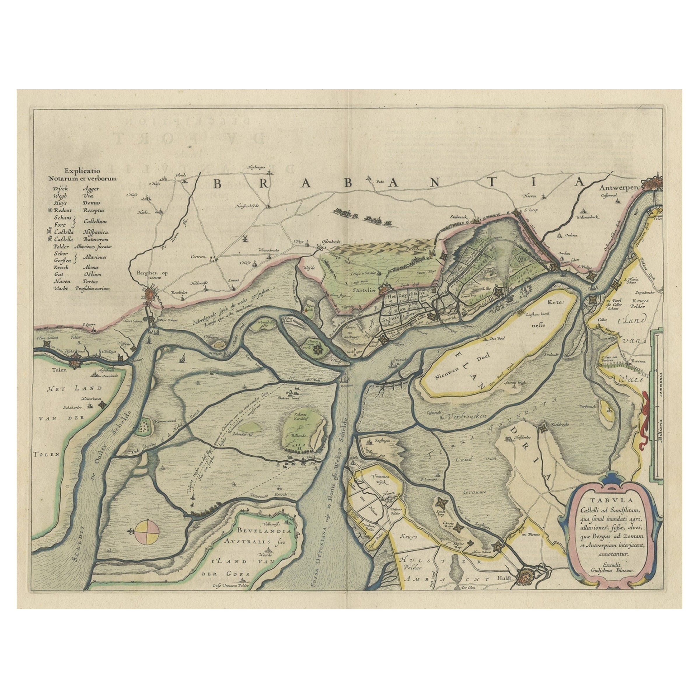
Items Similar to Antique Map of the region between Bergen op Zoom, Sandvliet, Hulst and Antwerp


Want more images or videos?
Request additional images or videos from the seller
1 of 6
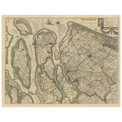
Antique Map of the region between Bergen op Zoom, Sandvliet, Hulst and Antwerp
$515.36
$644.2020% Off
£380.96
£476.2020% Off
€432
€54020% Off
CA$714.83
CA$893.5420% Off
A$779.32
A$974.1520% Off
CHF 411.78
CHF 514.7220% Off
MX$9,583.83
MX$11,979.7920% Off
NOK 5,120.14
NOK 6,400.1720% Off
SEK 4,819.93
SEK 6,024.9120% Off
DKK 3,289.46
DKK 4,111.8220% Off
About the Item
Original antique map titled 'Tabula Castelli ad Sandflitam (..)'. Detailed map of the region between Bergen op Zoom, Sandvliet, Hulst and Antwerp. Published by J. Janssonius, circa 1647.
- Dimensions:Height: 19.38 in (49.2 cm)Width: 23.04 in (58.5 cm)Depth: 0.02 in (0.5 mm)
- Materials and Techniques:
- Period:Mid-17th Century
- Date of Manufacture:1647
- Condition:Wear consistent with age and use. Strong toning. Stain in upper margin, sl. affecting image. Original folding line. Original / contemporary hand coloring. Latin text on verso. Minor wear and foxing. Please study image carefully.
- Seller Location:Langweer, NL
- Reference Number:Seller: BG-13144-11stDibs: LU3054331145562
About the Seller
5.0
Recognized Seller
These prestigious sellers are industry leaders and represent the highest echelon for item quality and design.
Platinum Seller
Premium sellers with a 4.7+ rating and 24-hour response times
Established in 2009
1stDibs seller since 2017
2,620 sales on 1stDibs
Typical response time: <1 hour
- ShippingRetrieving quote...Shipping from: Langweer, Netherlands
- Return Policy
Authenticity Guarantee
In the unlikely event there’s an issue with an item’s authenticity, contact us within 1 year for a full refund. DetailsMoney-Back Guarantee
If your item is not as described, is damaged in transit, or does not arrive, contact us within 7 days for a full refund. Details24-Hour Cancellation
You have a 24-hour grace period in which to reconsider your purchase, with no questions asked.Vetted Professional Sellers
Our world-class sellers must adhere to strict standards for service and quality, maintaining the integrity of our listings.Price-Match Guarantee
If you find that a seller listed the same item for a lower price elsewhere, we’ll match it.Trusted Global Delivery
Our best-in-class carrier network provides specialized shipping options worldwide, including custom delivery.More From This Seller
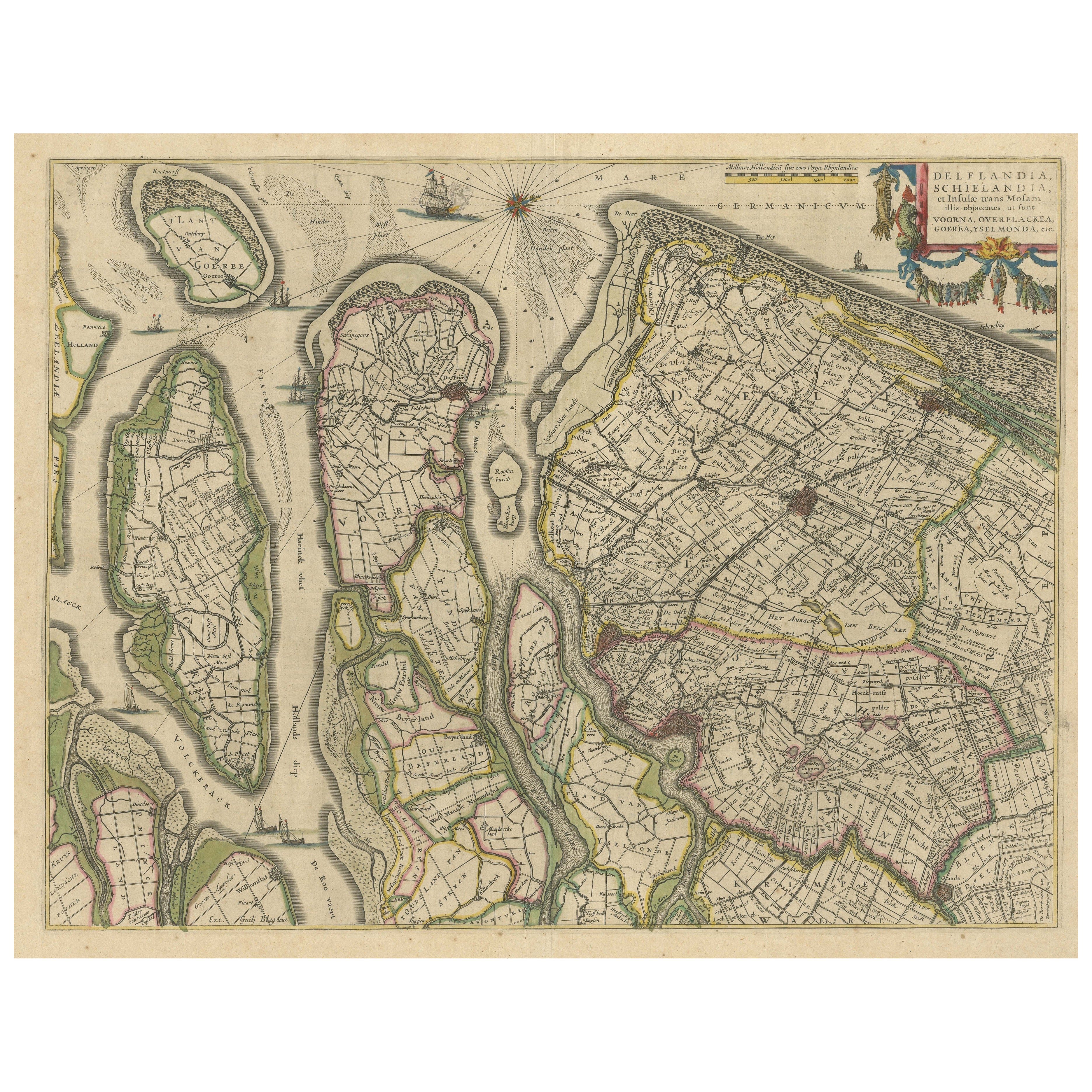
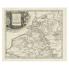
View AllAntique Map of Delfland, Schieland and Islands of Zuid-Holland, the Netherlands
Located in Langweer, NL
Antique map titled 'Delflandia, Schielandia, et Insulae (..)'. Original antique map of Delfland, Schieland and islands of Zuid-Holland, the Netherlands. The 'Zuid-Hollandse Eilanden'...
Category
Antique Mid-17th Century Maps
Materials
Paper
$658 Sale Price
20% Off
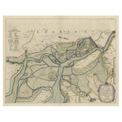
Original Map of the Military Situation After the Dutch Blockade of Antwerp, 1648
Located in Langweer, NL
Antique map titled 'Tabula Castelli ad Sandflitam (..)'.
This map depicts the complex military situation that had developed after the Dutch blockade of Antwerp. All entrenchment'...
Category
Antique 1640s Maps
Materials
Paper
$639 Sale Price
20% Off
Antique Map of Overijssel by Van Jagen, 1771
Located in Langweer, NL
Antique map titled 'L'Over-Issel'. This map depicts the Dutch province Overijssel. This map originates from 'Nouvel Atlas, très exact et fort commode pour toutes sortes de personnes,...
Category
Antique 18th Century Maps
Materials
Paper

$181 Sale Price
20% Off
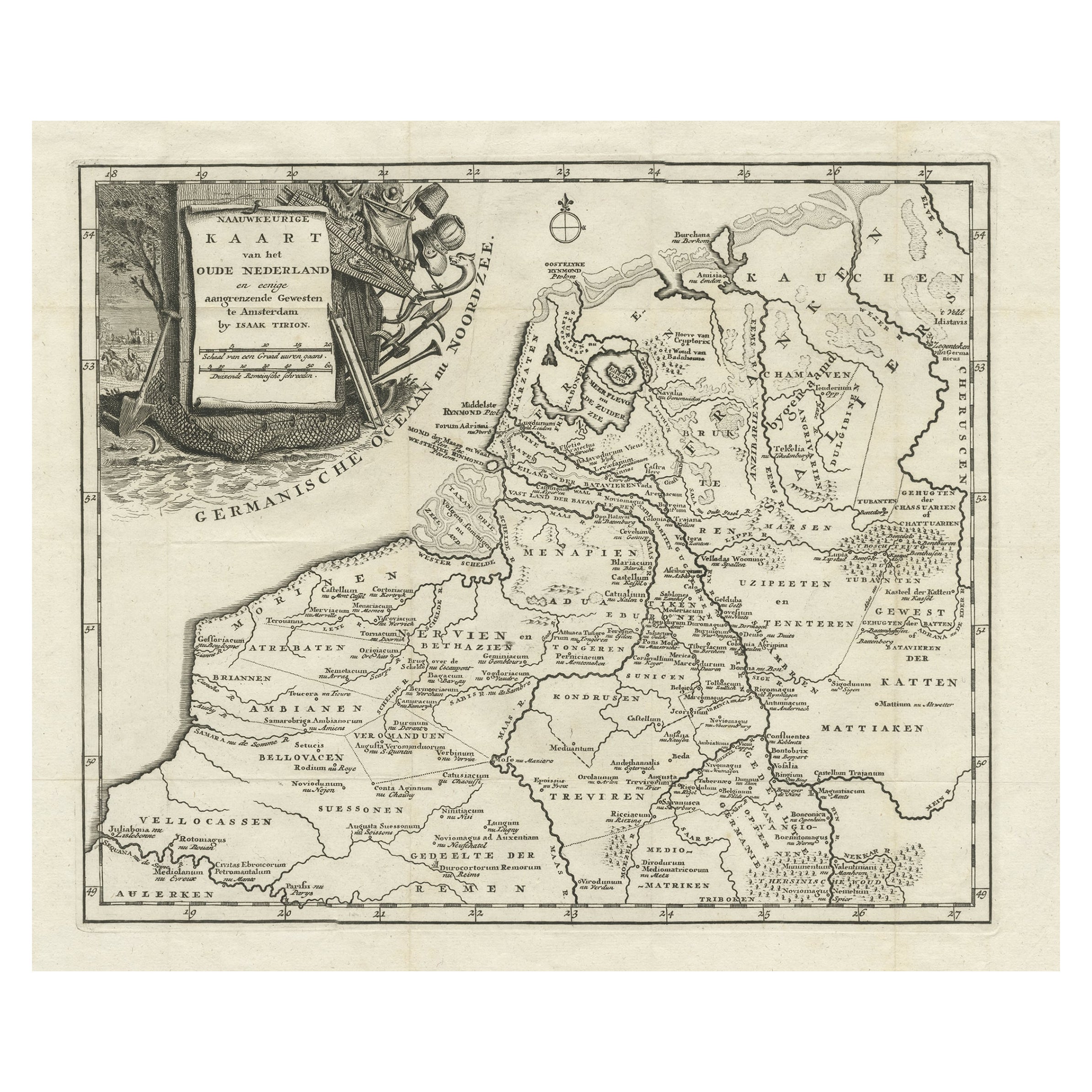
Original Antique Map of the Ancient Netherlands and Belgium, c.1750
Located in Langweer, NL
Description: Antique map titled 'Naauwkeurige Kaart van het Oude Nederland (..)'.
Original antique map of the Netherlands and Belgium. This map originates from 'Vaderlandsche his...
Category
Antique 1750s Maps
Materials
Paper
$334 Sale Price
20% Off
Antique Map of Friesland in the Netherlands, 1770
Located in Langweer, NL
Antique map titled 'De Synode van Friesland, in VI Klassen verdeeld door W.A. Bachiene?. Map of the province of Friesland, the Netherlands. This map originates from 'Nieuwe kerkelyke...
Category
Antique 18th Century Maps
Materials
Paper

$143 Sale Price
20% Off
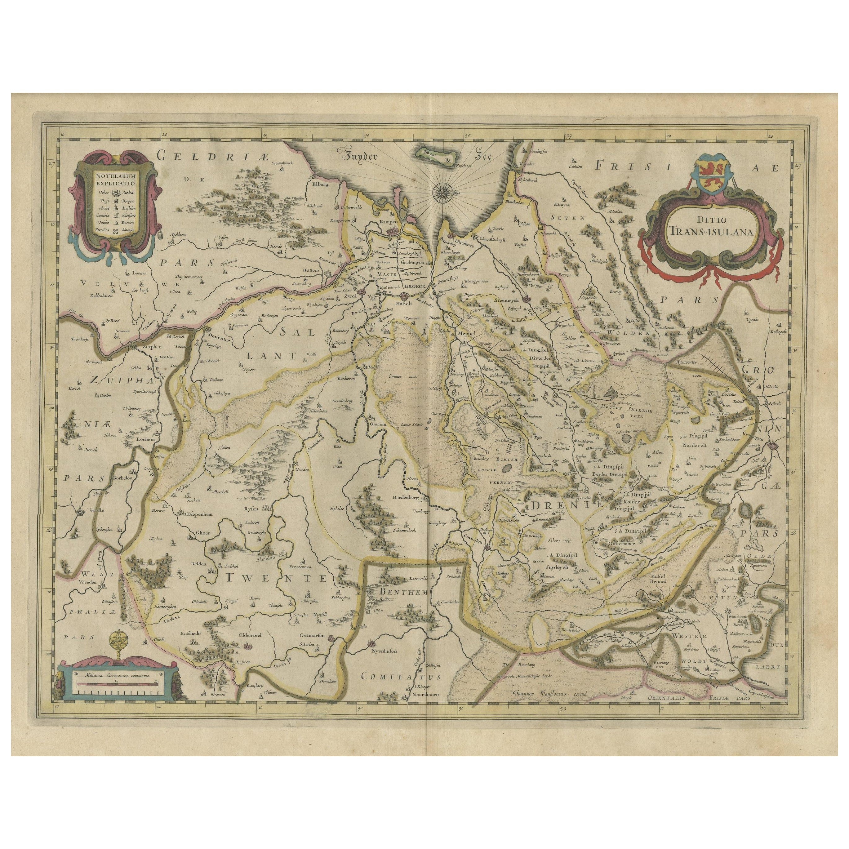
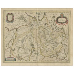
Antique Map of the Province of Overijssel, the Netherlands
Located in Langweer, NL
Original antique map titled 'Ditio Trans-Isulana'. Original old map of the province of Overijssel, the Netherlands. With coat of arms and two decorative cartouches. Published by J. J...
Category
Antique Mid-17th Century Maps
Materials
Paper
$467 Sale Price
20% Off
You May Also Like
1752 Vaugoundy Map of Flanders : Belgium, France, and the Netherlands, Ric.a002
Located in Norton, MA
Large Vaugoundy Map of Flanders:
Belgium, France, and the Netherlands
Colored -1752
Ric.a002
Description: This is a 1752 Didier Robert de Vaugondy map of Flanders. The map de...
Category
Antique 17th Century Unknown Maps
Materials
Paper

1633 Map "La Souverainete De Sedan Et De Raucourt, Et La Prevoste Ric0011
Located in Norton, MA
1653 map entitled
"La Souverainete de Sedan et de Raucourt, et la Prevoste de Doncheri,"
Ric0011
Description:
Lovely map centered on Sedan and Doncheri and the Meuze River fr...
Category
Antique 17th Century Dutch Maps
Materials
Paper

1643 Willem&Joan Blaeu Map NW Flanders "Flandriae Teutonicae Pars Prientalior
Located in Norton, MA
1643 Willem and Joan Blaeu map of northwest Flanders, entitled
"Flandriae Teutonicae Pars Prientalior,"
Ric0012
" Authentic" - Map of the northwest Fl...
Category
Antique 17th Century Dutch Maps
Materials
Paper

Antique Colored Belgium Map Flandria Gallica Flanders Henricus Hondius
Located in Dayton, OH
Antique hand colored map of Flanders, Belgium, engraved by Henricus Hondius.
Sans frame - 21.25” x 18”.
Category
Antique 19th Century Renaissance Maps
Materials
Paper

$280 Sale Price
20% Off
1771 Bonne Map of Poitou, Touraine and Anjou, France, Ric.a015
Located in Norton, MA
1771 Bonne Map of Poitou,
Touraine and Anjou, France
Ric.a015
1771 Bonne map of Potiou, Touraine and Anjou entitled "Carte des Gouvernements D'Anjou et du Saumurois, de la Touraine, du Poitou,du Pays d'aunis, Saintonge?Angoumois,"
Carte des gouvernements d'Anjou et du Saumurois, de la Touraine, du Poitou, du Pays d'Aunis, Saintonge-Angoumois. Projettee et assujettie au ciel par M. Bonne, Hyd. du Roi. A Paris, Chez Lattre, rue St. Jacques a la Ville de Bord(ea)ux. Avec priv. du Roi. 1771. Arrivet inv. & sculp., Atlas moderne ou collection de cartes sur toutes...
Category
Antique 17th Century Unknown Maps
Materials
Paper

1635 Willem Blaeu Map of Northern France"Comitatvs Bellovacvm" Ric.a08
Located in Norton, MA
1635 Willem Blaeu map of northern France, entitled.
"Comitatvs Bellovacvm Vernacule Beavvais,"
Colored
Ric.a008
“COMITATVS BELLOVACVM…” Amsterdam: W...
Category
Antique 17th Century Unknown Maps
Materials
Paper
