Items Similar to Antique Map of Southeast Asia from Persia to the Timor Island, 1712


Want more images or videos?
Request additional images or videos from the seller
1 of 5
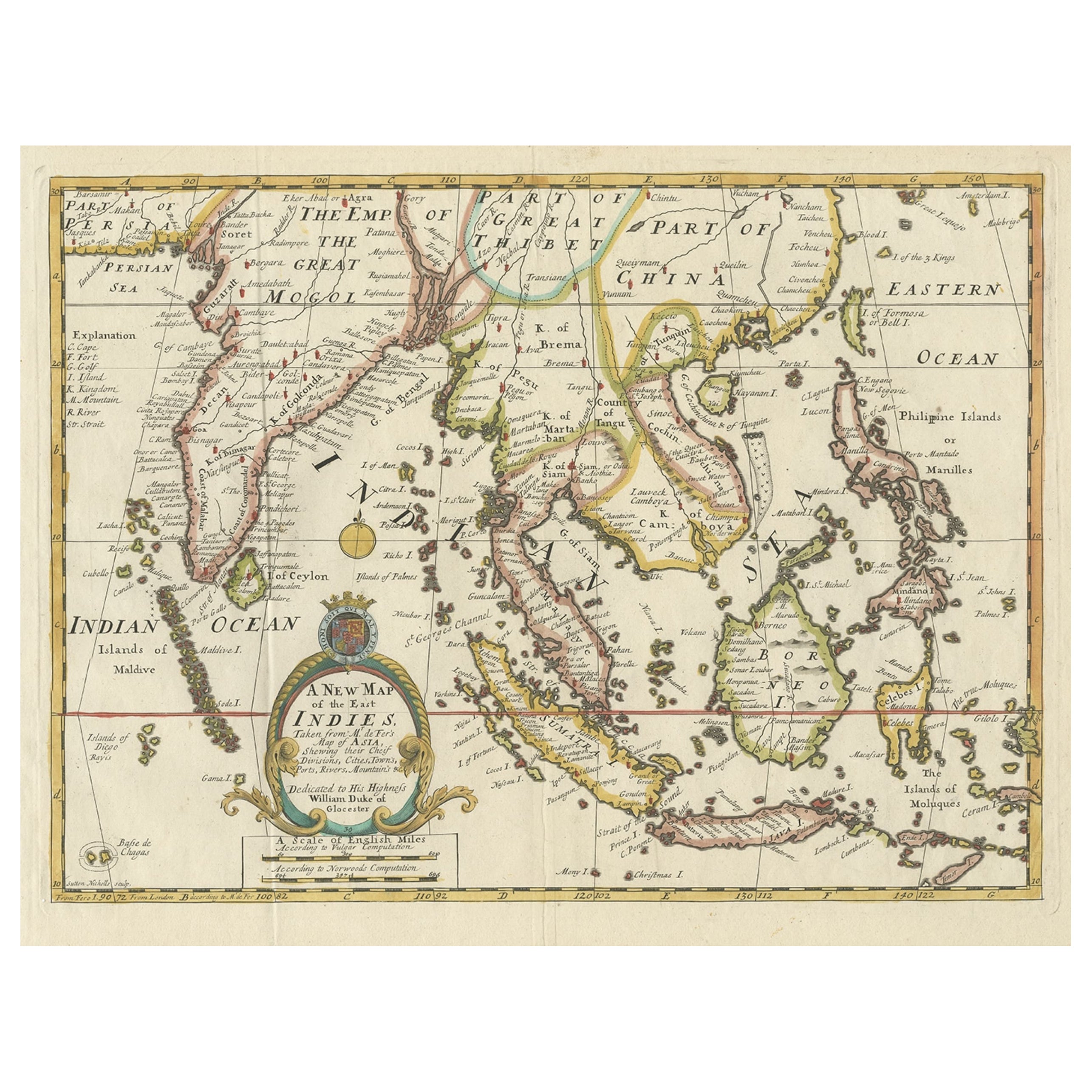
Antique Map of Southeast Asia from Persia to the Timor Island, 1712
$755.29
$944.1220% Off
£559.14
£698.9320% Off
€632
€79020% Off
CA$1,045.14
CA$1,306.4220% Off
A$1,152.06
A$1,440.0820% Off
CHF 602.81
CHF 753.5220% Off
MX$14,135.45
MX$17,669.3220% Off
NOK 7,588.24
NOK 9,485.3020% Off
SEK 7,096.20
SEK 8,870.2520% Off
DKK 4,812.04
DKK 6,015.0620% Off
About the Item
Antique map titled 'A New Map of the East Indies'.
Old map covering all of Southeast Asia from Persia to the Timor Island, inclusive of the modern day nations of India, Ceylon, Thailand, Burma (Myanmar), Malaysia, Cambodia, Vietnam, Laos, Indonesia, Borneo, and the Philippines. Based on Nicholas De Fer's map of Asia, the map renders the region in detail offering both topographical and political information with mountains beautifully rendered in profile. The Island of Singapore is shown but not labeled. Bali (Baly) and Lombok (Lombock) as well as Batavia are identified. Most of the Great Sunda Islands as well as the Lesser Sunda Islands, which were largely unexplored well into the 19th century, are mapped speculatively. Depicts a fairly narrow India and a misshaped Taiwan. This map originates from 'A New Sett of Maps both of Ancient and Present Geography' by E. Wells.
Artists and Engravers: Edward Wells (1667 - 1727) was an English mathematician, geographer, and classical scholar based at Christ Church College, Oxford. Well's was trained for the ministry but quickly found himself unsuited to religious life and instead applied for an academic position at Oxford, where he authored numerous well respected works on a wide range of mathematical and scientific topics. He was chosen to tutor the young Prince William, the sickly son of Queen Anne. The two must have been quite close for Well's dedicated nearly all of the maps in his most important atlas, A New Sett of Maps both of Ancient and Present Geography. Sadly, he young prince died in July of 1700 shortly before the atlas was published. Nonetheless, Wells' geography proved popular and was published in number editions well into the 1730s.
- Dimensions:Height: 16.54 in (42 cm)Width: 21.07 in (53.5 cm)Depth: 0 in (0.02 mm)
- Materials and Techniques:
- Period:1710-1719
- Date of Manufacture:1712
- Condition:Repaired: Repair on folding line and lower margin. Condition: Fair, age-related toning. Repair on folding line and lower margin, some other defects and creasing. Blank verso, please study image carefully.
- Seller Location:Langweer, NL
- Reference Number:Seller: BGJC-3601stDibs: LU3054327593582
About the Seller
5.0
Recognized Seller
These prestigious sellers are industry leaders and represent the highest echelon for item quality and design.
Platinum Seller
Premium sellers with a 4.7+ rating and 24-hour response times
Established in 2009
1stDibs seller since 2017
2,613 sales on 1stDibs
Typical response time: <1 hour
- ShippingRetrieving quote...Shipping from: Langweer, Netherlands
- Return Policy
Authenticity Guarantee
In the unlikely event there’s an issue with an item’s authenticity, contact us within 1 year for a full refund. DetailsMoney-Back Guarantee
If your item is not as described, is damaged in transit, or does not arrive, contact us within 7 days for a full refund. Details24-Hour Cancellation
You have a 24-hour grace period in which to reconsider your purchase, with no questions asked.Vetted Professional Sellers
Our world-class sellers must adhere to strict standards for service and quality, maintaining the integrity of our listings.Price-Match Guarantee
If you find that a seller listed the same item for a lower price elsewhere, we’ll match it.Trusted Global Delivery
Our best-in-class carrier network provides specialized shipping options worldwide, including custom delivery.More From This Seller
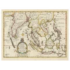
View AllOld Map Covering All of Southeast Asia from Persia to the Timor Island, 1712
Located in Langweer, NL
Description: Antique map titled 'A New Map of the East Indies'. Old map covering all of Southeast Asia from Persia to the Timor Island, inclusive of the modern day nations of India, ...
Category
Antique 1710s Maps
Materials
Paper
$1,434 Sale Price
20% Off
Old Antique Map of the East Indies and Southeast Asia, ca.1644
Located in Langweer, NL
Antique map titled 'India quae Orientalis dicitur, et Insulae adiacentes'.
Old map of the East Indies and Southeast Asia showing the area between India in the West and parts of Japan, the Marianas and New Guinea/Australia in the East. This map is dedicated to D. Christophorus Thisius by Henricus...
Category
Antique 1640s Dutch Maps
Materials
Paper

$2,375 Sale Price
25% Off
Original Antique Map of the Philippines, Malaysia, Indonesia, Singapore, c.1690
Located in Langweer, NL
Antique map titled 'Isole dell' Indie, diuise in Filippine, Molucche e della Sonda'.
Old map of the Philippines, Malaysia, Indonesia, Singapore, Northern Australia and contiguous i...
Category
Antique 1690s Maps
Materials
Paper

$2,151 Sale Price
20% Off
Free Shipping
Antique Map of India and Southeast Asia by Sanson '1654'
Located in Langweer, NL
Antique map titled 'Partie Meridionale de l'Inde'. Early map of India and Southeast Asia. The map shows most of modern India, Bangladesh and Burma, the whole of Sri Lanka, Thailand, ...
Category
Antique Mid-17th Century Maps
Materials
Paper

$1,147 Sale Price
20% Off
Rare Antique Map of the Dutch East Indies 'Indonesia', 1774
Located in Langweer, NL
Rare decorative engraved map of the Dutch East Indies, or nowadays Indonesia.
Title (in old Dutch): NIEUWE EN NAUKEURIGE KAART DER OOST-INDISCHE ...
Category
Antique 1770s Maps
Materials
Paper

$1,147 Sale Price
20% Off
Antique Map of Southeast Asia by J. Ottens, 1710
Located in Langweer, NL
Antique map titled 'Le Royaume de Siam avec Les Royaumes Qui Luy sont Tributaries'. Influential map of Southeast Asia. Ottens incorporated information provided by the French Jesuits ...
Category
Antique Early 18th Century Maps
Materials
Paper

$1,008 Sale Price
41% Off
You May Also Like
Antique 1803 Italian Map of Asia Including China Indoneseia India
Located in Amsterdam, Noord Holland
Antique 1803 Italian Map of Asia Including China Indoneseia India
Very nice map of Asia. 1803.
Additional information:
Type: Map
Country of Manufacturing: Europe
Period: 19th centu...
Category
Antique 19th Century European Maps
Materials
Paper

$584 Sale Price
20% Off
Antique French Map of Asia Including China Indoneseia India, 1783
Located in Amsterdam, Noord Holland
Very nice map of Asia. 1783 Dedie au Roy.
Additional information:
Country of Manufacturing: Europe
Period: 18th century Qing (1661 - 1912)
Condition: Overall Condition B (Good Used)...
Category
Antique 18th Century European Maps
Materials
Paper

$648 Sale Price
20% Off
Map of the East Indies: An Original 18th Century Hand-colored Map by E. Bowen
Located in Alamo, CA
This is an original 18th century hand-colored map entitled "An Accurate Map of the East Indies Exhibiting the Course of the European Trade both on the Continent and Islands" by Emanu...
Category
Mid-18th Century Old Masters Landscape Prints
Materials
Engraving

Original Antique Map of South East Asia by Thomas Clerk, 1817
Located in St Annes, Lancashire
Great map of South East Asia
Copper-plate engraving
Drawn and engraved by Thomas Clerk, Edinburgh.
Published by Mackenzie And Dent, 1817
Unframed.
Category
Antique 1810s English Maps
Materials
Paper

Tabula Indiae Orientalis - Etching by Frederick de Wit - 1680ca
By Frederick de Wit
Located in Roma, IT
This double-page etching with contemporary coloring, entitled Tabula Indiae orientalis, was realized by the cartographer Frederick de Wit for the famous Atlas published in Amsterdam ...
Category
1680s Modern Figurative Prints
Materials
Etching

Asia Declineatio: A 17th Century Hand-colored Map of Asia by Justus Danckerts
Located in Alamo, CA
This is a scarce 17th century beautifully hand-colored copperplate engraved map of Asia entitled “Exactissima Asiae Delineatio in Praecipuas Regiones Caerterasque Partes divisa et de...
Category
Late 17th Century Old Masters Landscape Prints
Materials
Engraving

More Ways To Browse
Singapore Antique
Taiwan Map
Laos Antique Map
Australian Colonial
Bengal Map
Mariners Chart
Northern Pacific Railroad
Papua New Guinea Antique Map
Stanford Furniture
Tennessee Antique Furniture
Used Office Furniture Maine
Ancient World Map
Antique Florida Map
Antique Geological Maps
Antique Map Chile
Antique Map Of Georgia
Antique Mississippi Furniture
Burgundy Map