Items Similar to Cortesi's Masterpiece: A Comprehensive and Authoritative Map of Uruguay, 1903

Want more images or videos?
Request additional images or videos from the seller
1 of 9
Cortesi's Masterpiece: A Comprehensive and Authoritative Map of Uruguay, 1903
$5,244.23
$6,555.2920% Off
£3,883.32
£4,854.1520% Off
€4,400
€5,50020% Off
CA$7,211.60
CA$9,014.5020% Off
A$8,021.15
A$10,026.4420% Off
CHF 4,198.10
CHF 5,247.6220% Off
MX$97,831.60
MX$122,289.5020% Off
NOK 52,750.64
NOK 65,938.3020% Off
SEK 49,618.79
SEK 62,023.4920% Off
DKK 33,498.56
DKK 41,873.2020% Off
About the Item
Antique map titled 'Mapa de la Republica Oriental del Uruguay'. Large and detailed folding map of Uruguay. This monumental map depicts all of Uruguay with unprecedented accuracy and detail. Impressively, it serves the multiple roles of being an advanced topographic, economic and political map, as well as being a meticulous sea chart of the Rio de la Plata and the adjacent waters of the Atlantic. The republic's 20 departments are defined in various colors, while a legend, 'Referencias' identifies symbols representing the locations of departmental capitals, town, roads, railways, public schools and lighthouses, amongst other details. Every single river and stream is delineated and named and the ridges of hills are delicately expressed. The map features four insets, including a large map of the capital, Montevideo, as well as maps of Colonia, Maldonado and Punta del Este and the Island of Flores. The hydrographical information provided is truly profound, and renders the map fit for use in maritime commerce.
In 1901, the Uruguayan House of Representatives commissioned the geographer Saturnino Cortesi to employ the most progressive geographical sources, both military and civilian, to devise an authoritative national map of the republic. Cortesi clearly had access to a vast archive of topographical surveys, as well as sea charts issued by Britain's Royal Navy. As stated on the map, Cortesi's manuscript was reviewed and approved by the National Department of Engineers and authorized for its publication by decree of the Ministry of Development of Uruguay ('El presente mapa construido por Saturnino Cortesi y Anibal C. Mendez ha sido examinado y aprobado Departamento N. de Ingenieros y autorizada su publicacion por decreto del Ministerio de Fomento').
Cortesi was assisted in preparing the map for publication by Anibal C. Mendez, and it was chromolithographed by La Minerva Tipografia y Lithografia in Montevideo. Issued in 1903, it was by far the grandest map ever printed in Uruguay to date.
Cortesi's Mapa de la Republica Oriental del Uruguay was the authoritative and official national map of Uruguay, and appeared at an especially critical time in the republic's history. The second half of the 19th-century had been a time of tremendous instability in the wake of the great civil war, La Guerra Grande (1839-51). In 1903, the year the map was issued, José Batlle y Ordoñez was elected president, ushering in a generation of economic prosperity and relative political stability. The present map would have served as a vital tool in planning Uruguay's development during this period of rapid growth and change.
Reference: Proceedings of the Second Pan American Scientific Congress (Washington, D.C., 1917), p.656.
- Dimensions:Height: 72.84 in (185 cm)Width: 50.79 in (129 cm)Depth: 0.02 in (0.5 mm)
- Materials and Techniques:
- Period:
- Date of Manufacture:1903
- Condition:Repaired: Rebacking with linen. Minor structural damages. Few traces of worm holes (nearly invisible because of rebacking). Please study images carefully.
- Seller Location:Langweer, NL
- Reference Number:Seller: BG-117891stDibs: LU3054321296522
About the Seller
5.0
Recognized Seller
These prestigious sellers are industry leaders and represent the highest echelon for item quality and design.
Platinum Seller
Premium sellers with a 4.7+ rating and 24-hour response times
Established in 2009
1stDibs seller since 2017
2,599 sales on 1stDibs
Typical response time: <1 hour
- ShippingRetrieving quote...Shipping from: Langweer, Netherlands
- Return Policy
Authenticity Guarantee
In the unlikely event there’s an issue with an item’s authenticity, contact us within 1 year for a full refund. DetailsMoney-Back Guarantee
If your item is not as described, is damaged in transit, or does not arrive, contact us within 7 days for a full refund. Details24-Hour Cancellation
You have a 24-hour grace period in which to reconsider your purchase, with no questions asked.Vetted Professional Sellers
Our world-class sellers must adhere to strict standards for service and quality, maintaining the integrity of our listings.Price-Match Guarantee
If you find that a seller listed the same item for a lower price elsewhere, we’ll match it.Trusted Global Delivery
Our best-in-class carrier network provides specialized shipping options worldwide, including custom delivery.More From This Seller
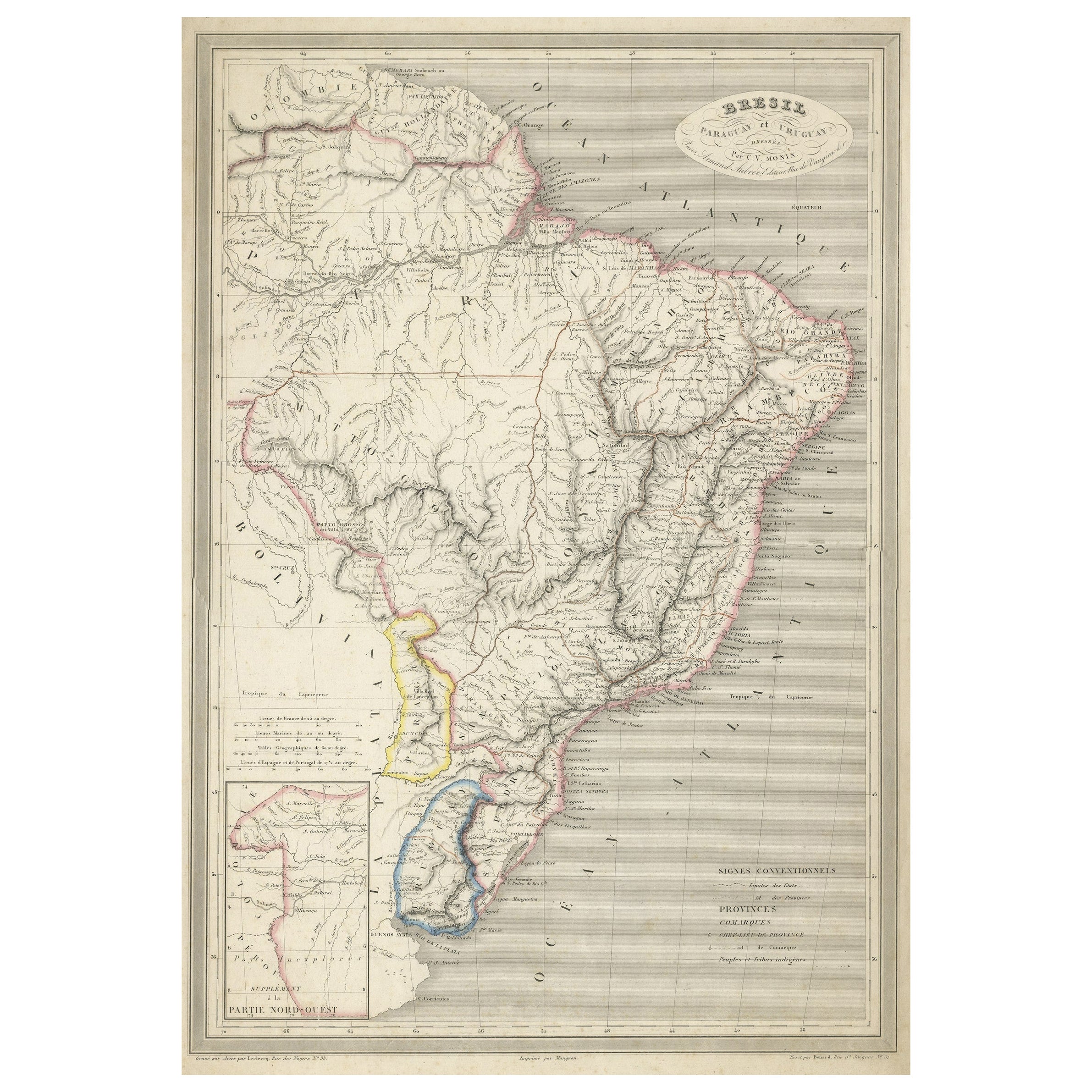
View AllAntique Map of of Brazil, Paraguay and Uruguay
Located in Langweer, NL
Antique map titled 'Bresil Paraguay et Uruguay'. Fine steel engraved map of Brazil, Paraguay and Uruguay. Engraved by Leclercq and published by Armand Aubree in "Atlas Classique et U...
Category
Antique Mid-19th Century Maps
Materials
Paper
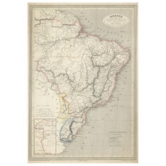
$324 Sale Price
20% Off
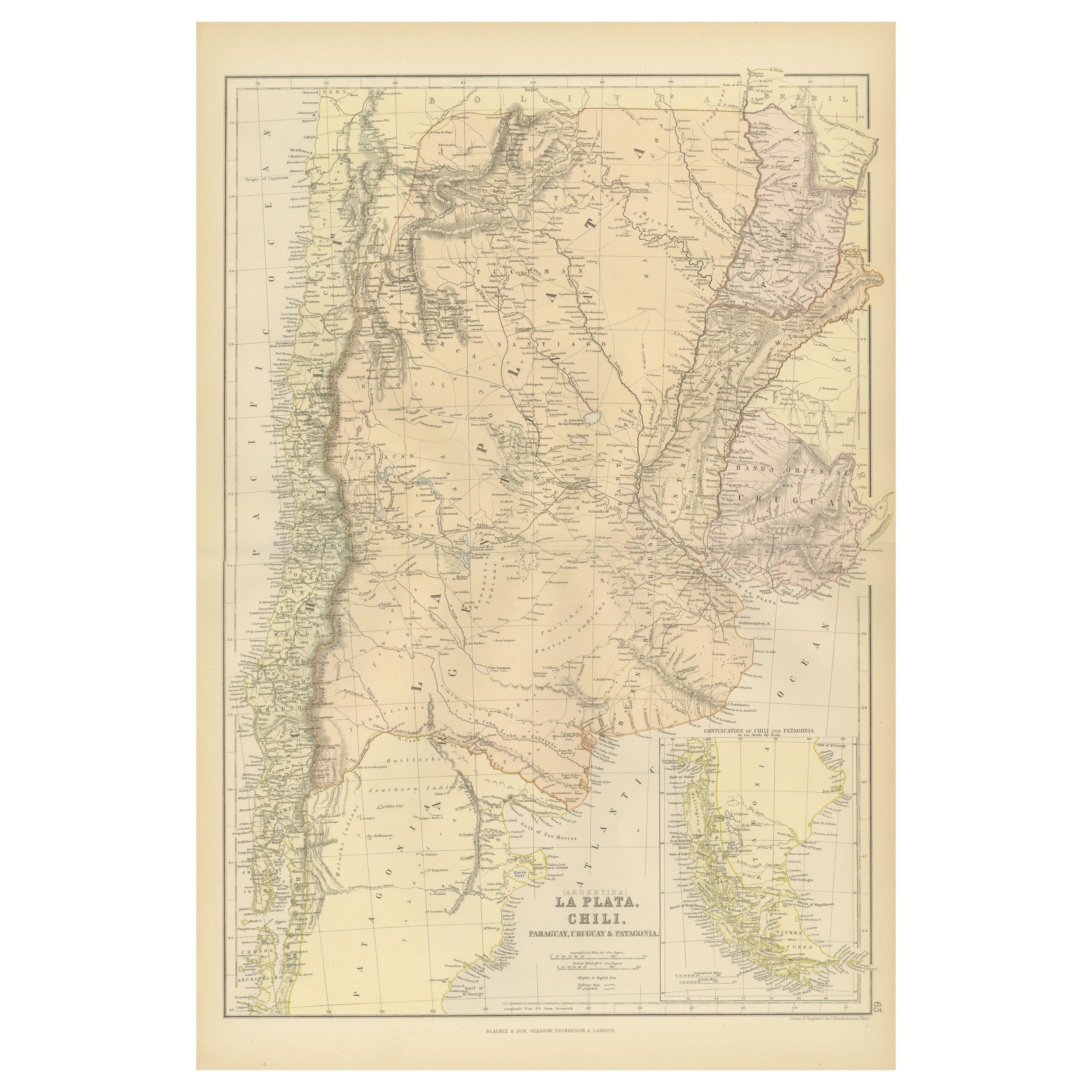
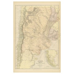
1882 Map of Argentina, La Plata, Chile, Paraguay, Uruguay, and Patagonia
Located in Langweer, NL
This 1882 map, published as part of the 'Comprehensive Atlas and Geography of the World' by Blackie and Son, provides an intricate depiction of Argentina, La Plata, Chile, Paraguay, ...
Category
Antique 1880s Maps
Materials
Paper
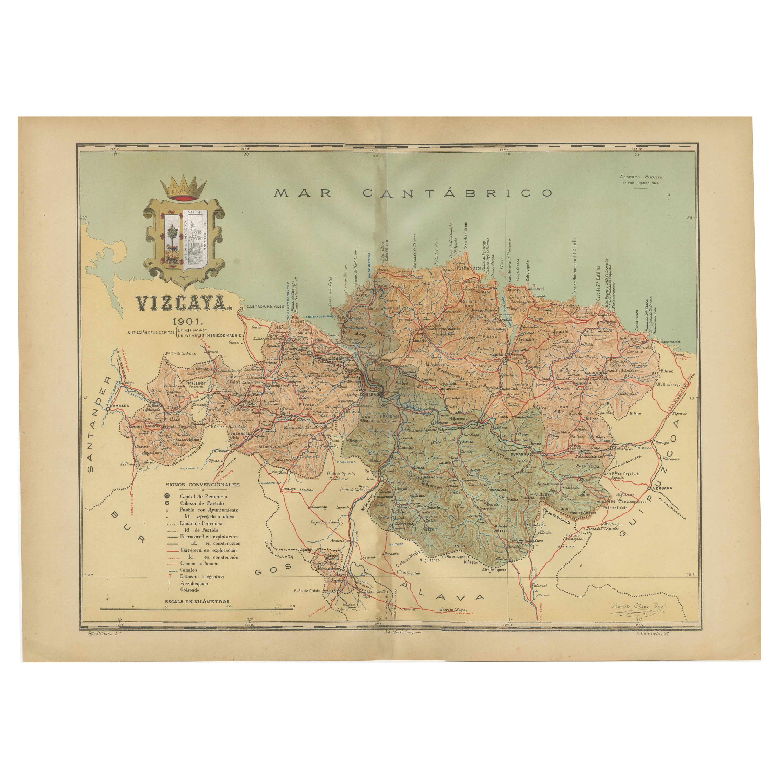
Cartographic Heritage: The 1901 Map of the Vizcaya Province in Spain
Located in Langweer, NL
This is a historical map of the province of Vizcaya (Biscay) in Spain, dated 1901. The title on the map is "VIZCAYA. 1901." It shows the topographical details of the region with cont...
Category
Antique Early 1900s Maps
Materials
Paper
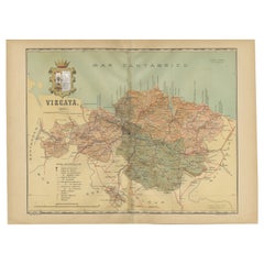
$305 Sale Price
20% Off
Free Shipping
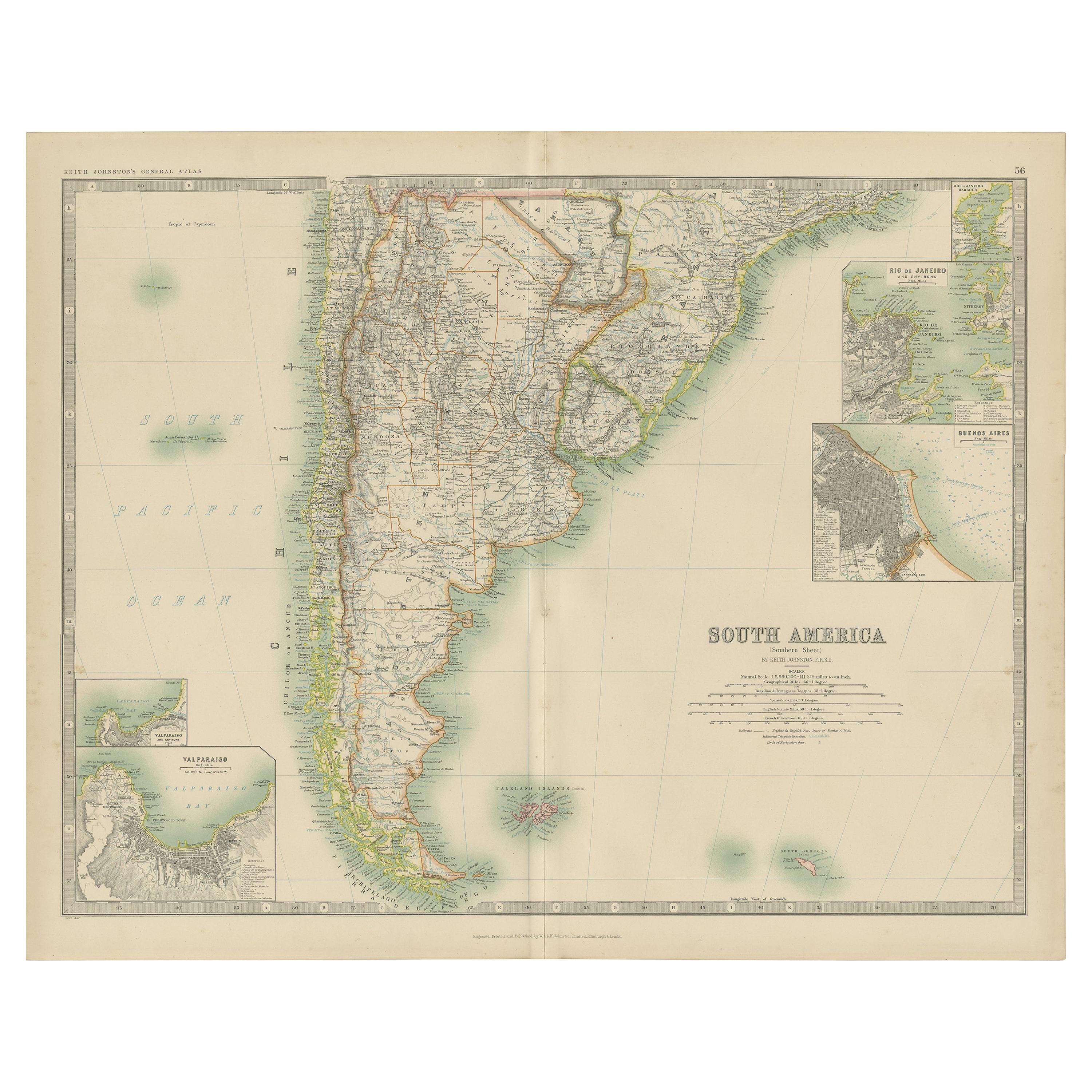
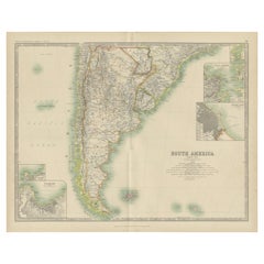
Antique Map of South America by Johnston '1909'
Located in Langweer, NL
Antique map titled 'South America, Southern Sheet'. Depicting Chile, Argentina, Brazil, Patagonia, the Falkland Island and more. With inset maps of Valparaiso, Rio de Janeiro and Bue...
Category
Early 20th Century Maps
Materials
Paper
$238 Sale Price
20% Off
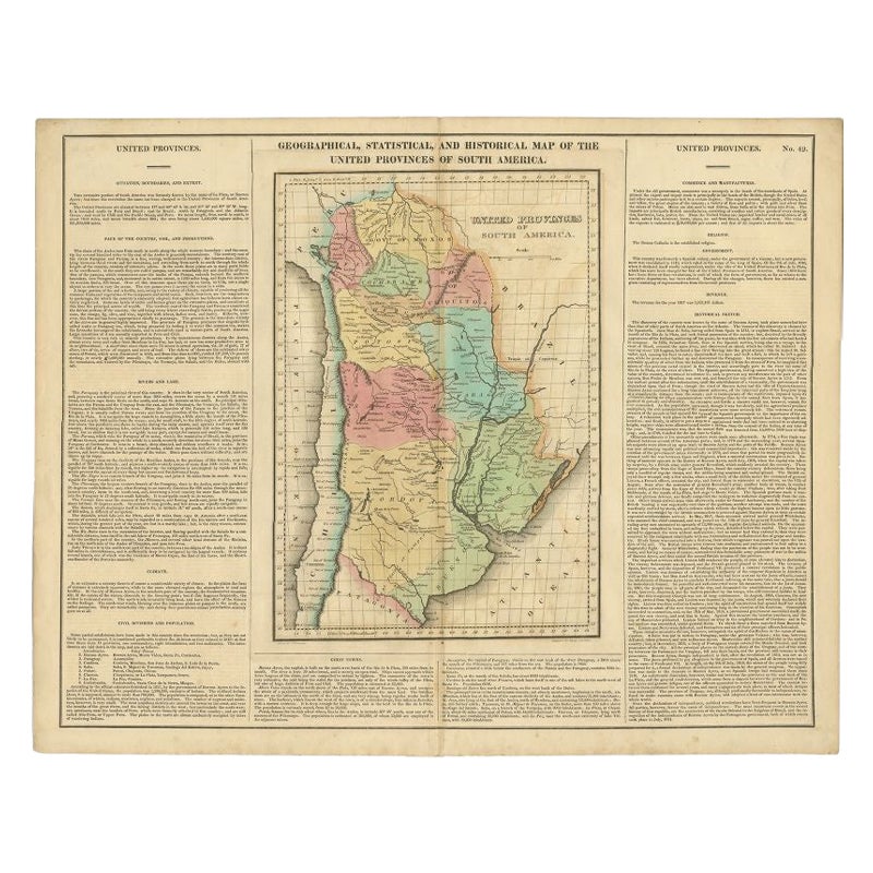
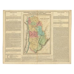
Antique Map of South America by Finlayson, 1822
Located in Langweer, NL
Antique map titled 'Geographical, Statistical and Historical Map of the United Provinces of South America'. This map depicts part of South America (including part of Brazil and Chili...
Category
Antique 19th Century Maps
Materials
Paper
$255 Sale Price
20% Off
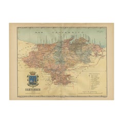
Maritime and Terrestrial Survey of Spanish Santander in 1901, An Original Map
Located in Langweer, NL
This antique map is a historical map of the province of Santander (currently known as Cantabria) from the year 1901. Santander is located along the northern coast of Spain, bordering...
Category
Antique Early 1900s Maps
Materials
Paper
$276 Sale Price
20% Off
Free Shipping
You May Also Like
Large Original Vintage Map of Spain, circa 1920
Located in St Annes, Lancashire
Great map of Spain
Original color.
Good condition
Published by Alexander Gross
Unframed.
Category
Vintage 1920s English Maps
Materials
Paper

South America, Eastern Part. Century Atlas antique vintage map
Located in Melbourne, Victoria
'The Century Atlas. South America. Eastern Part'
Original antique map, 1903.
Inset map 'Rio de Janeiro and Vicinity'.
Central fold as issued. Map name and number printed on the rev...
Category
Early 20th Century Victorian More Prints
Materials
Lithograph

Antique Lithography Map, South America, English, Framed, Cartography, Victorian
Located in Hele, Devon, GB
This is an antique lithography map of South America. An English, framed atlas engraving of cartographic interest by John Rapkin , dating to the early Victorian period and later, circ...
Category
Antique Mid-19th Century British Early Victorian Maps
Materials
Wood

Antique Map of South America in Roma Frame
Located in Malibu, CA
Antique map of South America. Displayed in a new Roma frame with museum quality matting. Custom frame in platinum. No print date, but cert...
Category
Antique Late 19th Century Victorian Prints
Materials
Hardwood, Paper

South America, North-West Part. Century Atlas antique vintage map
Located in Melbourne, Victoria
'The Century Atlas. South America, North-West Part'
Original antique map, 1903.
Central fold as issued. Map name and number printed on the reverse corners.
Sheet 40cm by 29.5cm.
Category
Early 20th Century Victorian More Prints
Materials
Lithograph

Original Antique Decorative Map of South America-West Coast, Fullarton, C.1870
Located in St Annes, Lancashire
Great map of Chili, Peru and part of Bolivia
Wonderful figural border
From the celebrated Royal Illustrated Atlas
Lithograph. Original color.
Published by Fullarton, Edi...
Category
Antique 1870s Scottish Maps
Materials
Paper

More Ways To Browse
Railway Map
British Royal Navy
Map Of Great Britain
Civil War Map
Antique Civil War Maps
Antique School Chart
Antique Maps Scotland
Denmark Map
Antique Maps Of North America
Wine Map
Map Greece
Roman Map
Antique Maps Of Russia
Antique Roman Map
Maps Of Mediterranean
Mercator Map
Antique Railroad Furniture
Atlas Globe