Items Similar to Hand Colored Antique Map of the Department of Basses-Alpes, France


Want more images or videos?
Request additional images or videos from the seller
1 of 6
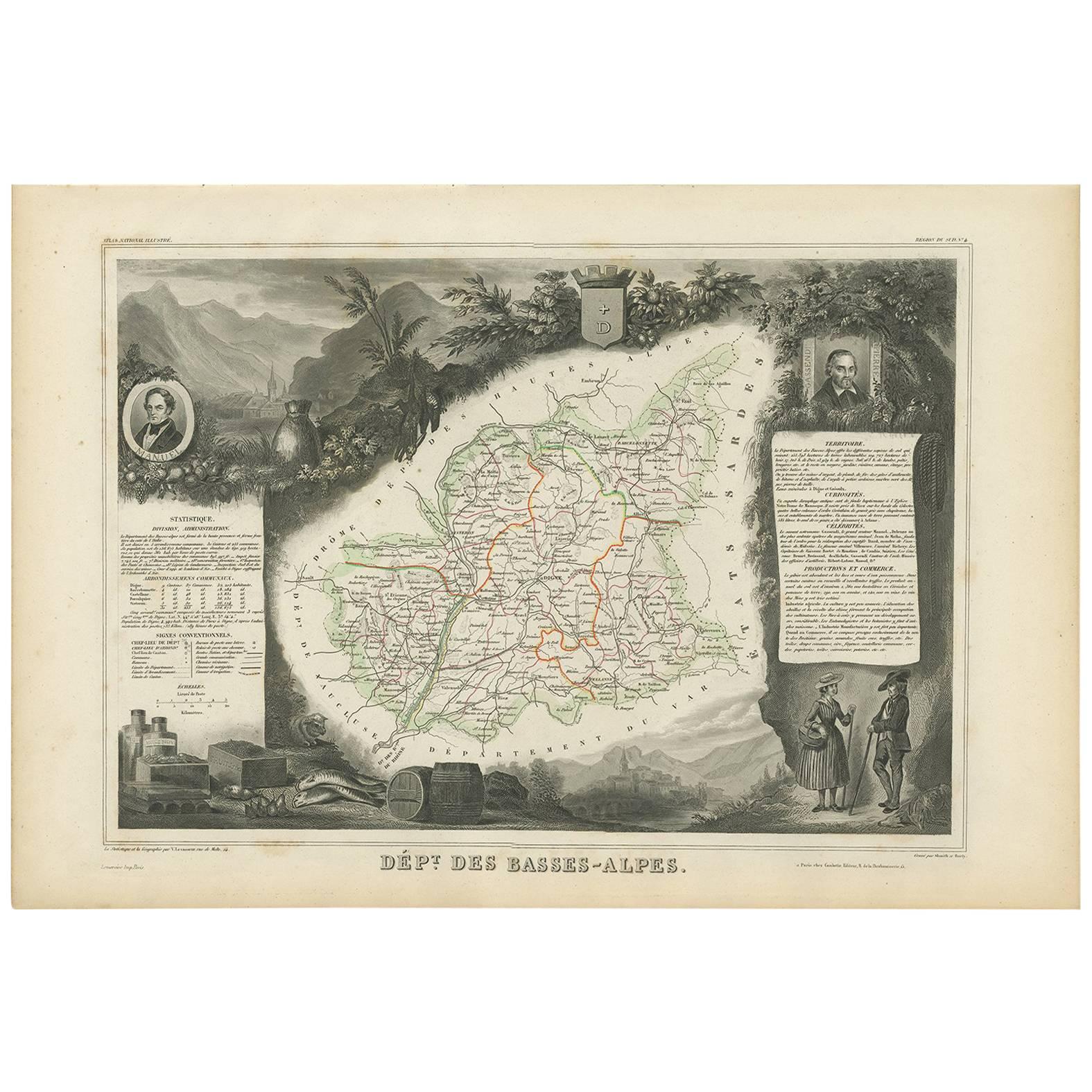
Hand Colored Antique Map of the Department of Basses-Alpes, France
$325.06
$406.3320% Off
£240.64
£300.8120% Off
€272
€34020% Off
CA$449.81
CA$562.2620% Off
A$495.82
A$619.7820% Off
CHF 259.44
CHF 324.3020% Off
MX$6,083.61
MX$7,604.5220% Off
NOK 3,265.82
NOK 4,082.2820% Off
SEK 3,054.06
SEK 3,817.5820% Off
DKK 2,071.01
DKK 2,588.7620% Off
About the Item
Antique map titled 'Dépt. de l'Aube'. Map of the French department of Basses-Alpes, France. The whole is surrounded by elaborate decorative engravings designed to illustrate both the natural beauty and trade richness of the land. There is a short textual history of the regions depicted on both the left and right sides of the map.
This map originates from 'Atlas National de la France Illustree' published by V. Levasseur, circa 1852.
Victor Levasseur (1800–1870) was a French cartographer widely known for his distinctive decorative style. He produced numerous maps more admired for the artistic content of the scenes and data surrounding the map than for the detail of the map. Victor Levasseur's "Atlas National Illustré" and "Atlas Universel Illustré" are among the last great decorative atlases published.
- Creator:Victor Levasseur (Artist)
- Dimensions:Height: 14.49 in (36.8 cm)Width: 20.36 in (51.7 cm)Depth: 0.02 in (0.5 mm)
- Materials and Techniques:
- Period:
- Date of Manufacture:circa 1852
- Condition:Wear consistent with age and use. General age-related toning. Shows some wear and soiling, blank verso. Few small tears/splits in margins. Please study images carefully.
- Seller Location:Langweer, NL
- Reference Number:Seller: BG-13216-251stDibs: LU3054331479802
Victor Levasseur
Victor Jules Levasseur (1795–1862) was a French cartographer widely known for his distinctive decorative style. He produced numerous maps more admired for the artistic content of the scenes and data surrounding the map than for the detail of the map. Victor Levasseur was born in 1795 in France. Little is known about his early life and education, but he emerged as one of the most prominent French cartographers of the 19th century. Levasseur lived during a time of significant political and geographical changes in France and Europe, which greatly influenced his work as a mapmaker.
About the Seller
5.0
Recognized Seller
These prestigious sellers are industry leaders and represent the highest echelon for item quality and design.
Platinum Seller
Premium sellers with a 4.7+ rating and 24-hour response times
Established in 2009
1stDibs seller since 2017
2,615 sales on 1stDibs
Typical response time: <1 hour
- ShippingRetrieving quote...Shipping from: Langweer, Netherlands
- Return Policy
Authenticity Guarantee
In the unlikely event there’s an issue with an item’s authenticity, contact us within 1 year for a full refund. DetailsMoney-Back Guarantee
If your item is not as described, is damaged in transit, or does not arrive, contact us within 7 days for a full refund. Details24-Hour Cancellation
You have a 24-hour grace period in which to reconsider your purchase, with no questions asked.Vetted Professional Sellers
Our world-class sellers must adhere to strict standards for service and quality, maintaining the integrity of our listings.Price-Match Guarantee
If you find that a seller listed the same item for a lower price elsewhere, we’ll match it.Trusted Global Delivery
Our best-in-class carrier network provides specialized shipping options worldwide, including custom delivery.More From This Seller
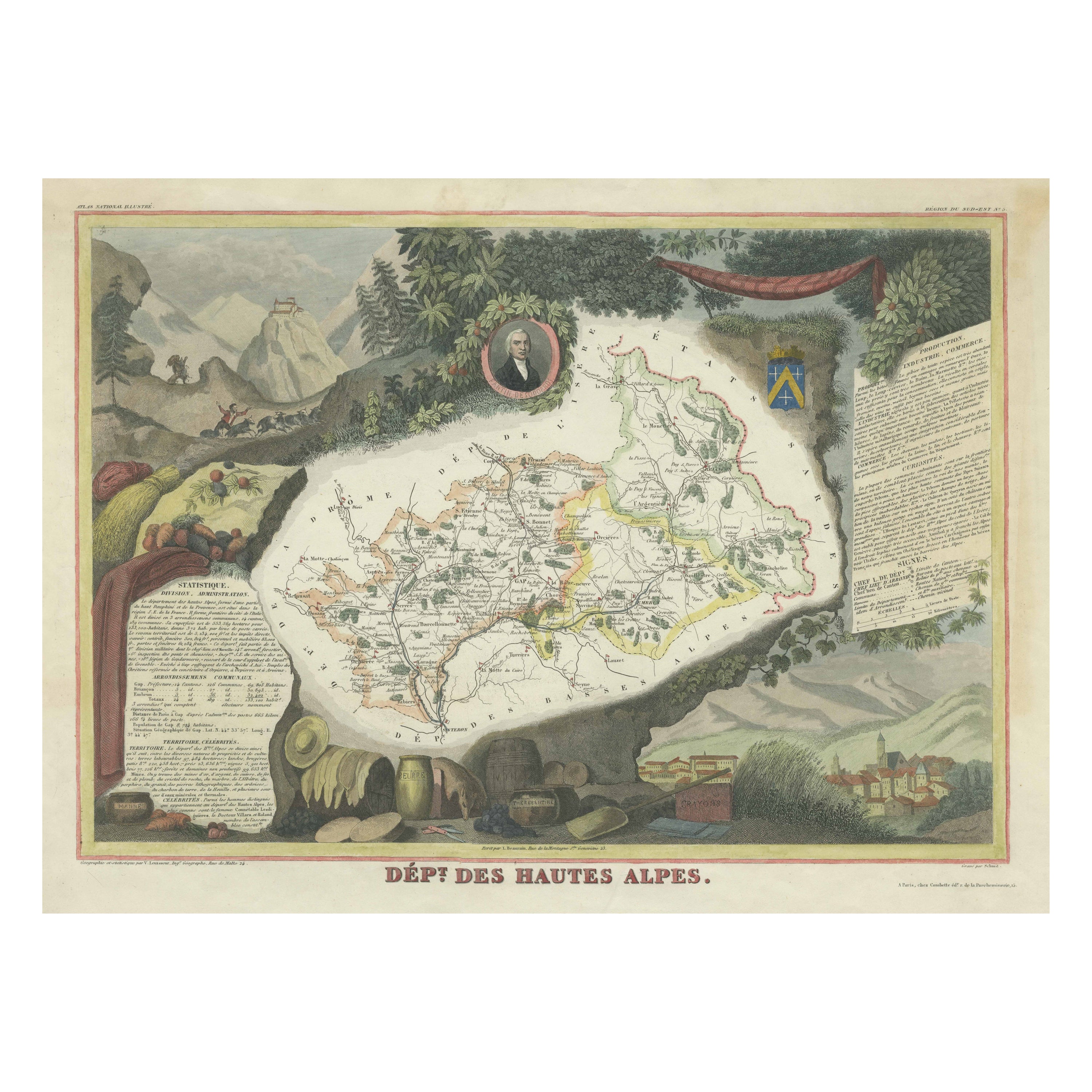
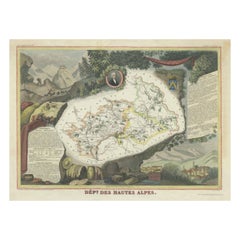
View AllHand Colored Antique Map of the department of Hautes Alpes, France
By Victor Levasseur
Located in Langweer, NL
Antique map titled 'Dépt. des Hautes Alpes'. Map of the French department of Hautes Alpes, France. This area of France is known for its production of Cote...
Category
Antique Mid-19th Century Maps
Materials
Paper
$325 Sale Price
20% Off
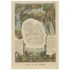
Hand Colored Antique Map of the department of Lozere, France
By Victor Levasseur
Located in Langweer, NL
Antique map titled 'Dept. de la Lozère'. Map of the French department of Lozere, France. This remote mountainous part of Languedoc is rural, sparcely populated, and extremely beautif...
Category
Antique Mid-19th Century Maps
Materials
Paper
$325 Sale Price
20% Off
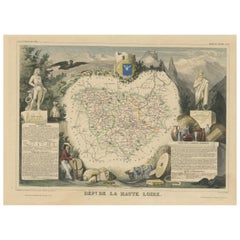
Hand Colored Antique Map of the Department of Haute Loire, France
By Victor Levasseur
Located in Langweer, NL
Antique map titled 'Dept. de la Haute Loire'. Map of the French department of Haute Loire, France. This area of France is part of the Loire Valley wine growing...
Category
Antique Mid-19th Century Maps
Materials
Paper
$325 Sale Price
20% Off
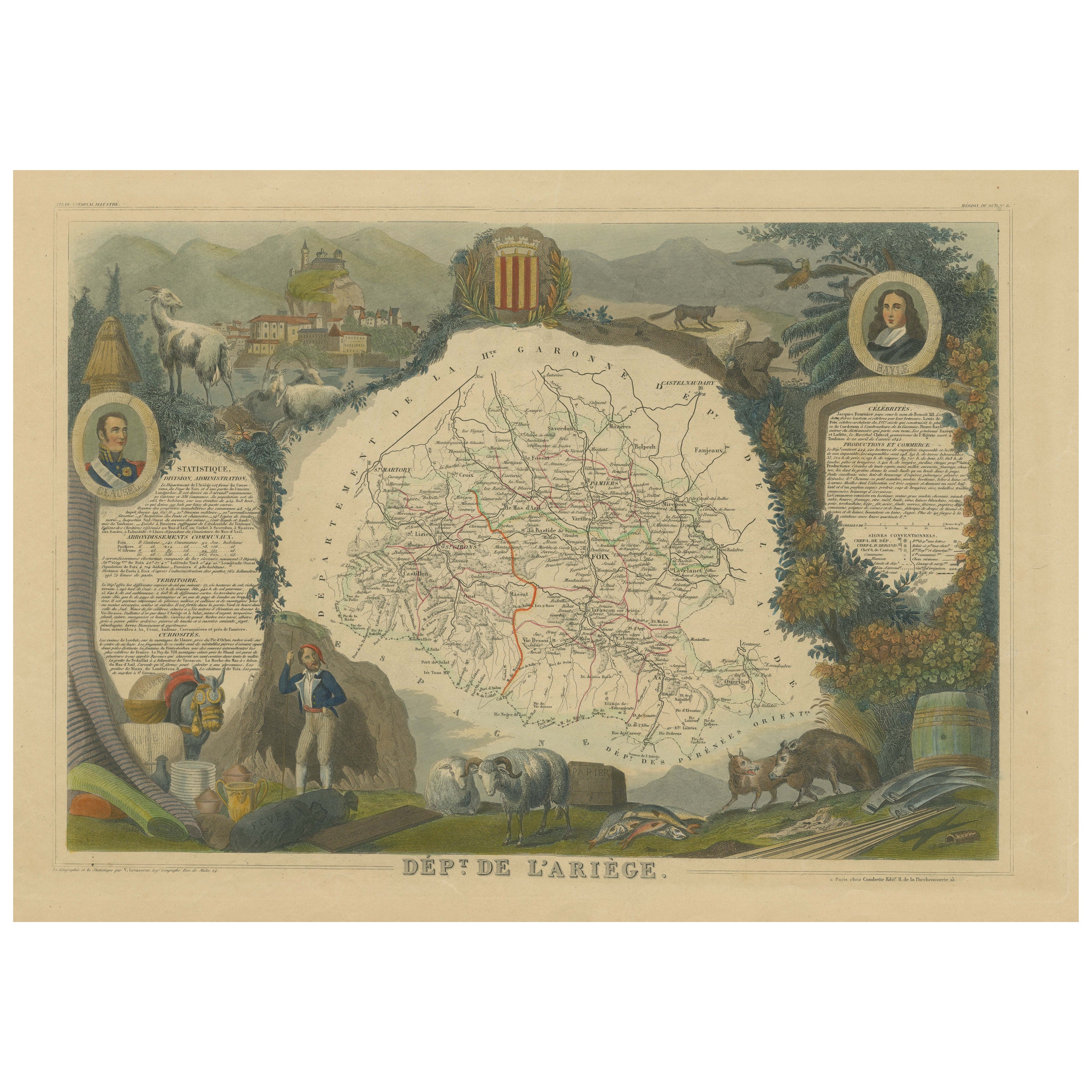
Hand Colored Antique Map of the Department of Ariège, France
By Victor Levasseur
Located in Langweer, NL
Antique map titled 'Dépt. de l'Ariège'. Map of the French department of Ariege, France. This area of France is known for its production of semi-soft and mild cheeses, such as Bethmal...
Category
Antique Mid-19th Century Maps
Materials
Paper
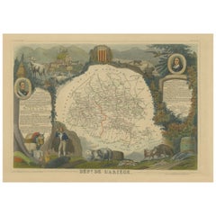
$325 Sale Price
20% Off
Antique Map of Basses-Alpes ‘France’ by V. Levasseur, 1854
By Victor Levasseur
Located in Langweer, NL
Antique map titled 'Dépt. des Basses-Alpes'. Map of the French department of Basses-Alpes, France. The whole is surrounded by elaborate decorative engravings designed to illustrate b...
Category
Antique Mid-19th Century Maps
Materials
Paper
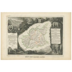
$191 Sale Price
20% Off
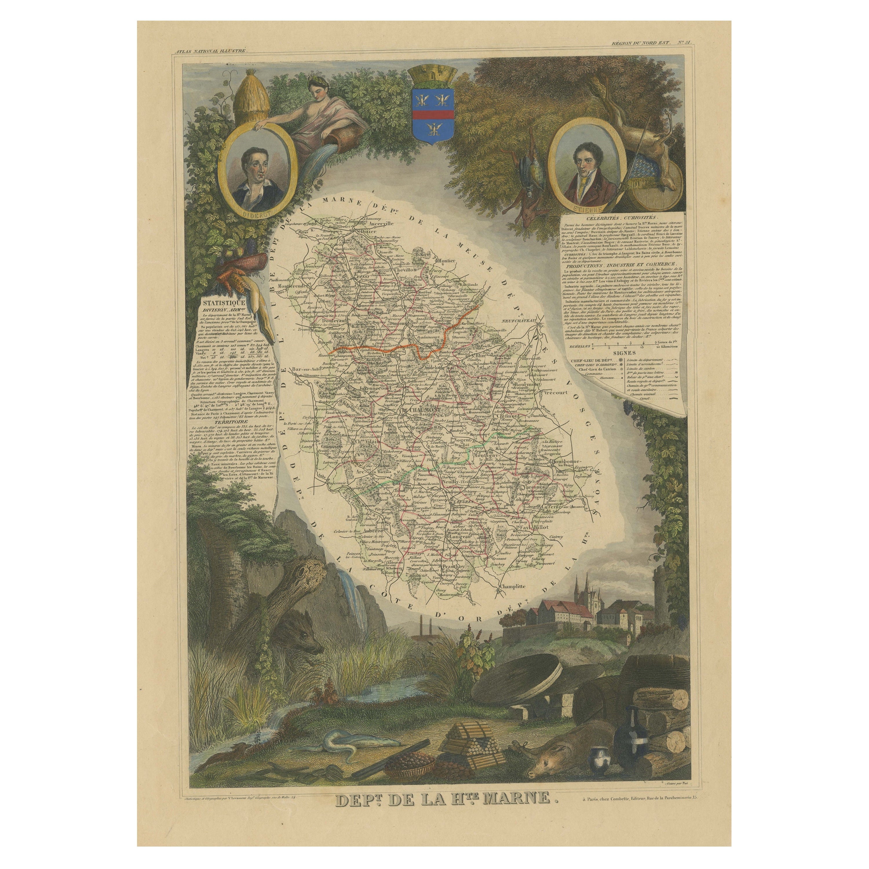
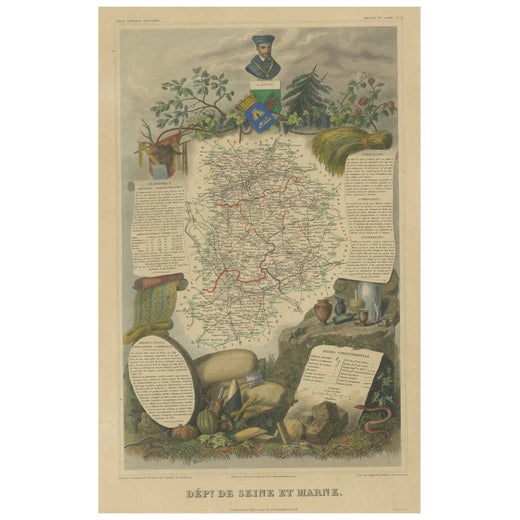
Hand Colored Antique Map of the Department of Haute Marne, France
By Victor Levasseur
Located in Langweer, NL
Antique map titled 'Dépt. de la Hte Marne'. Map of the French department of Haute Marne, France. This department is part of the Champagne region, where the world-famous sparkling win...
Category
Antique Mid-19th Century Maps
Materials
Paper
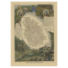
$325 Sale Price
20% Off
You May Also Like
Hautes Alpes, France. Antique map of a French department, 1856
By Victor Levasseur
Located in Melbourne, Victoria
'Dept. des Hautes Alpes', steel engraving with original outline hand-colouring., 1856, from Levasseur's 'Atlas National Illustre'.
This area of France i...
Category
19th Century Naturalistic Landscape Prints
Materials
Engraving

Fine Antique 1856 Hand Watercolour Map of Dept Des Hautes Alpes by Levasseur's
Located in West Sussex, Pulborough
We are delighted to offer for sale this stunning 1856 hand watercolour map of the Austrian Alps titled Dept Des Hautes Alpes taken from the Atlas National...
Category
Antique 1850s French Early Victorian Maps
Materials
Paper

$723 Sale Price
30% Off
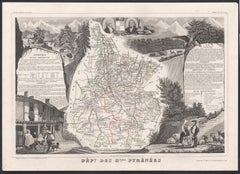
Fine French Antique 1856 Hand Watercolour Map of Dept Des Hautes Pyrenees
Located in West Sussex, Pulborough
We are delighted to offer for sale this stunning 1856 hand watercolour map of the Austrian Alps titled Dept Des Hautes Pyrenees taken from the Atlas Nat...
Category
Antique 1850s French Early Victorian Maps
Materials
Paper

$723 Sale Price
30% Off
Beautiful Colour French Antique 1856 Hand Watercolour Map of Dept Des La Corse
Located in West Sussex, Pulborough
We are delighted to offer for sale this stunning 1856 hand watercolour map of the Austrian Alps titled Dept Des La Course taken from the Atlas National ...
Category
Antique 1850s French Early Victorian Maps
Materials
Paper

$819 Sale Price
30% Off
Hautes Pyrenees, France. Antique map of a French department, 1856
By Victor Levasseur
Located in Melbourne, Victoria
'Dept. des Hautes Pyrenees', steel engraving with original outline hand-colouring., 1856, from Levasseur's Atlas National Illustre.
This area is home to the wine producing region, ...
Category
19th Century Naturalistic Landscape Prints
Materials
Engraving
Pyrenees Orientales, France. Antique map of a French department, 1856
By Victor Levasseur
Located in Melbourne, Victoria
'Dept. des Pyrenees Orientales', steel engraving with original outline hand-colouring., 1856, from Levasseur's 'Atlas National Illustre'.
This area is well-known wine producing reg...
Category
19th Century Naturalistic Landscape Prints
Materials
Engraving

More Ways To Browse
Alpes Furniture
E Fletcher
Framed Africa Maps
Gabon Antique Map
Hudson River Map
Mauritius Antique Map
Nova Hollandia
Used Furniture Cleveland Ohio
Vintage Bartholomew Maps
1820 World Map
Aden Yemen
Antique Map New Orleans
Dakota Johnson
French School Map
Miliens S
Ruben Benjamin
Washington Dc Map
Wood Carved Golfer