Items Similar to Handsome Old Detailed Map of the Low Countries by Famous Mapmaker Blaeu, ca.1635


Want more images or videos?
Request additional images or videos from the seller
1 of 5
Handsome Old Detailed Map of the Low Countries by Famous Mapmaker Blaeu, ca.1635
$3,523.08
£2,603.35
€2,950
CA$4,880.49
A$5,334.55
CHF 2,809.58
MX$65,593.38
NOK 35,111.97
SEK 33,033.43
DKK 22,464.04
About the Item
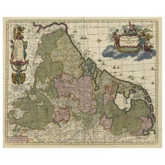
Antique map titled 'Novus XVII Inferioris Germaniae Provinciarum Typus'.
Handsome - and much sought after- detailed map of the Low Countries by the world most famous map maker Blaeu. With beautiful cartouches, coat of arms, compass rose, scale and many ships on the North Sea. Willem Blaeu published this map in 1608 as a wall map with figured borders. Later, in 1630, he needed a general map of the Netherlands for his first atlas, the Appendix, the decoration in the borders was sacrificed: the borders of the copper plates were cut off. It is one of the most decorative maps of present Netherlands, Belgium and Luxembourg. Still with the signature of "Willem Janszoon op't Water in de Vergulde Zonnewyzer." Spanish text on verso. Published circa 1635.
Artists and Engravers: The Blaeu firm was founded in 1596 by Willem Janzoon Blaeu (1571-1638). It was in this initial period, from 1596 to 1672, under the leadership of Willem Blaeu and with this assistance of his two talented sons Cornelius (1616-1648) and Johannis (1596-1673), that the firm was most active. Their greatest cartographic achievement was the publication of the magnificent multi-volume Atlas Major.
Condition: Good, given age. Minimal paper separation bottom middle fold, not affecting image. Some spots in the margins. Original middle fold as issued. General age-related toning and/or occasional minor defects from handling. Spanish text on verso. Please study image carefully.
- Dimensions:Height: 17.72 in (45 cm)Width: 23.12 in (58.7 cm)Depth: 0 in (0.02 mm)
- Materials and Techniques:
- Period:1630-1639
- Date of Manufacture:circa 1635
- Condition:
- Seller Location:Langweer, NL
- Reference Number:Seller: PC-58913 1stDibs: LU3054326706082
About the Seller
5.0
Recognized Seller
These prestigious sellers are industry leaders and represent the highest echelon for item quality and design.
Platinum Seller
Premium sellers with a 4.7+ rating and 24-hour response times
Established in 2009
1stDibs seller since 2017
2,620 sales on 1stDibs
Typical response time: <1 hour
- ShippingRetrieving quote...Shipping from: Langweer, Netherlands
- Return Policy
Authenticity Guarantee
In the unlikely event there’s an issue with an item’s authenticity, contact us within 1 year for a full refund. DetailsMoney-Back Guarantee
If your item is not as described, is damaged in transit, or does not arrive, contact us within 7 days for a full refund. Details24-Hour Cancellation
You have a 24-hour grace period in which to reconsider your purchase, with no questions asked.Vetted Professional Sellers
Our world-class sellers must adhere to strict standards for service and quality, maintaining the integrity of our listings.Price-Match Guarantee
If you find that a seller listed the same item for a lower price elsewhere, we’ll match it.Trusted Global Delivery
Our best-in-class carrier network provides specialized shipping options worldwide, including custom delivery.More From This Seller
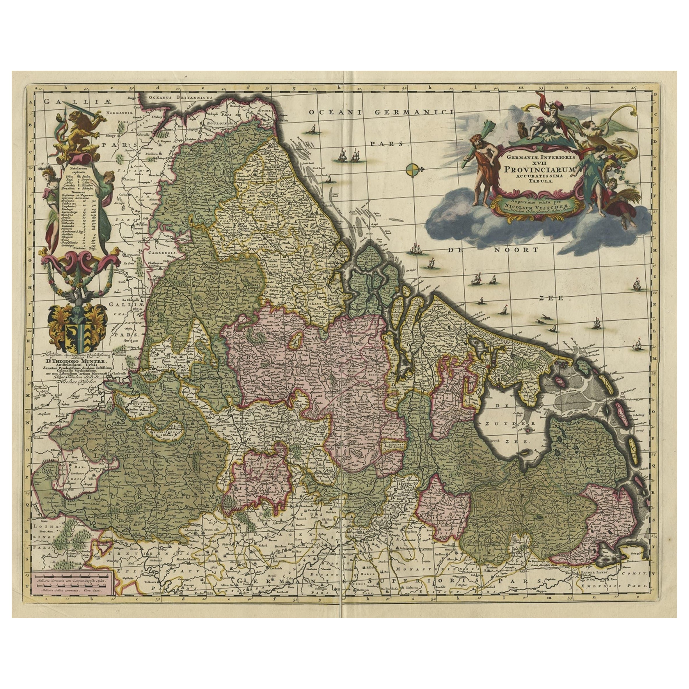
View AllAntique Decorative Map of the Low Countries, '17 Provinces, Netherlands', c.1680
Located in Langweer, NL
Description: Antique map titled 'Germaniae Inferioris XVII Provinciarum Accuratissima Tabula.'
Map of the low countries (17 provinces, Netherlands). The map is dedicated to Theod...
Category
Antique 1680s Maps
Materials
Paper
$1,385 Sale Price
20% Off
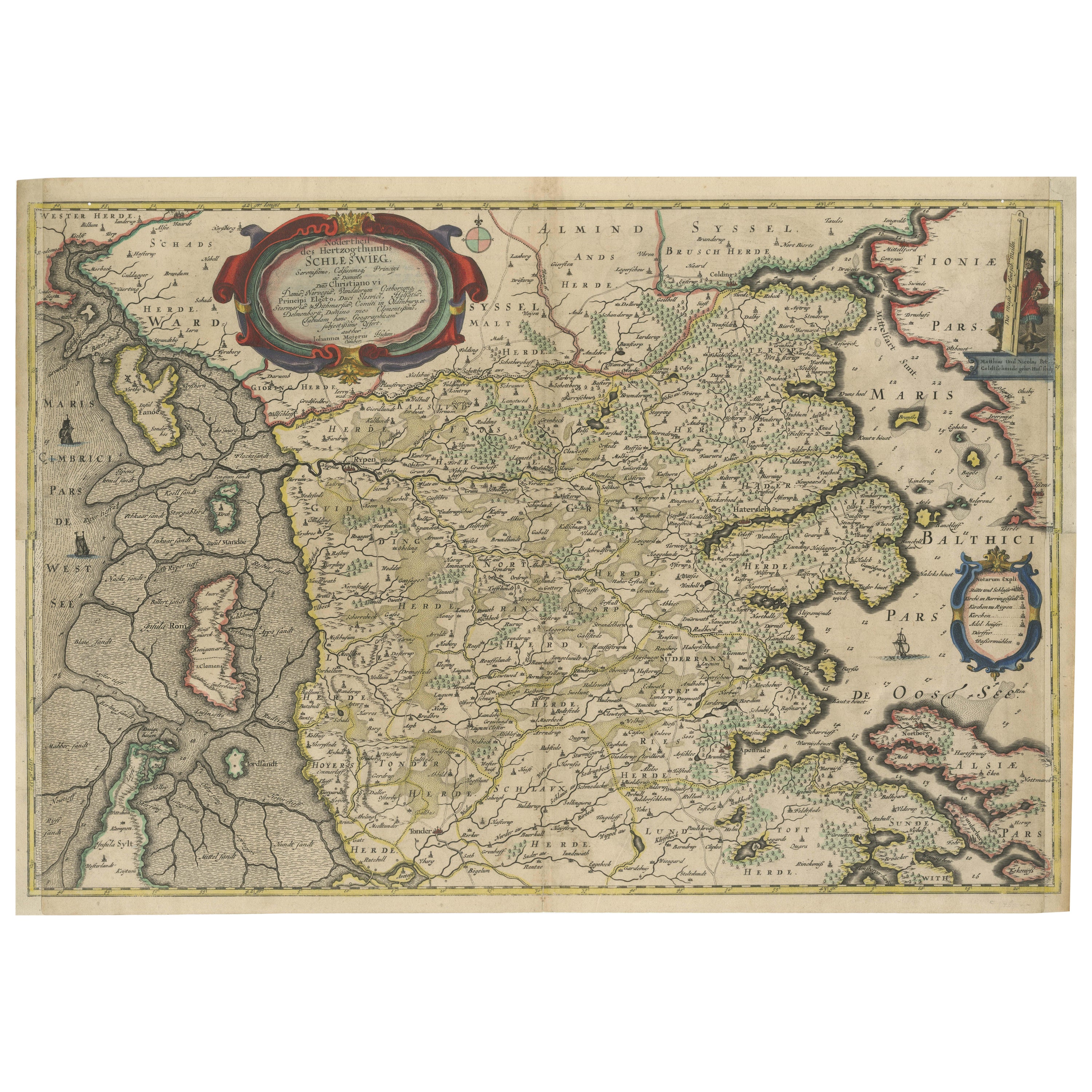
Northern Schleswig and Haderslev Map by Johannes Mejer and Johannes Blaeu, 1662
Located in Langweer, NL
The map shows the Duchy of Schleswig, which spans the area between the North Sea coast, Kolding, and Flensburg. The maps were originally published by Johannes Mejer in the regional a...
Category
Antique 1660s Maps
Materials
Paper

$535 Sale Price
20% Off
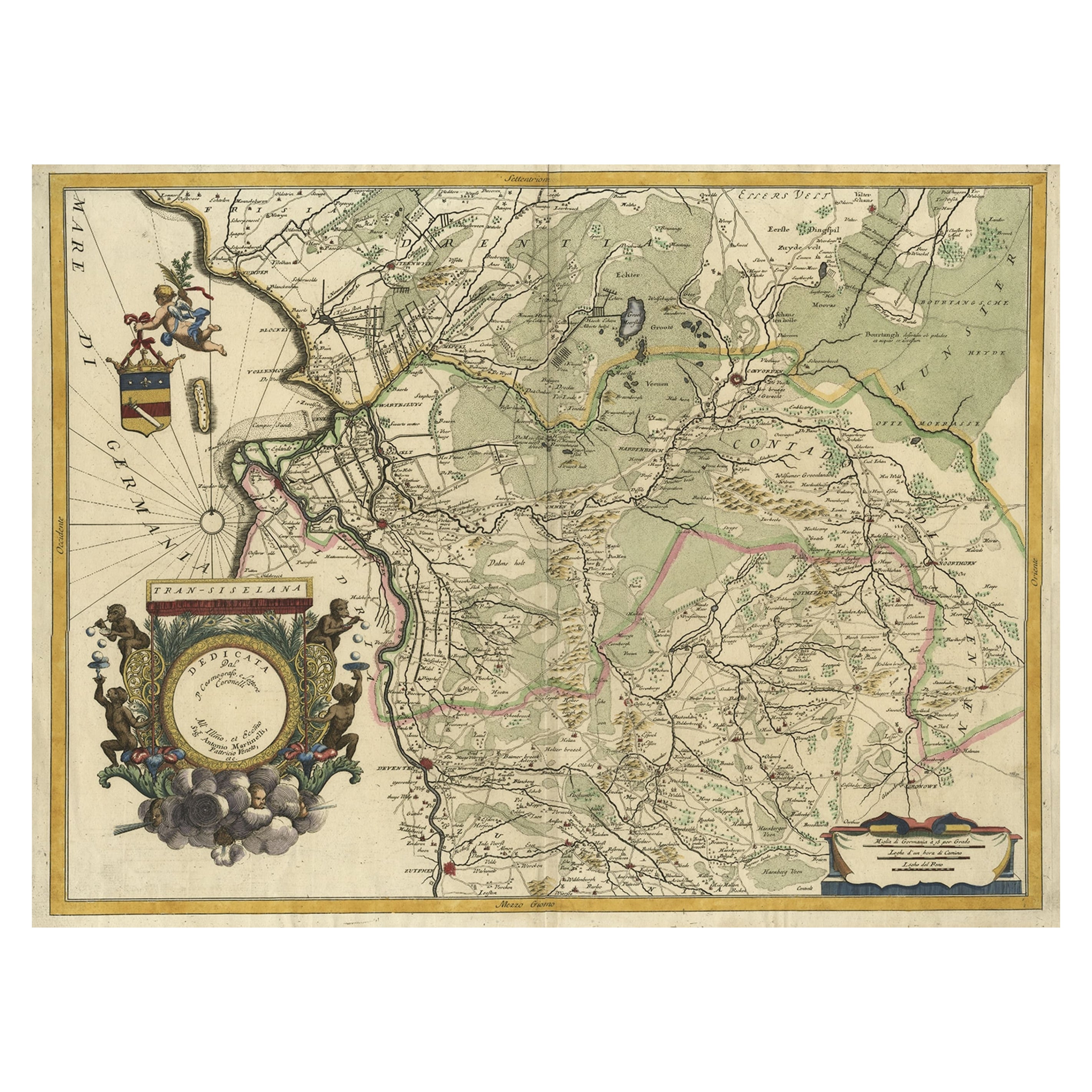
Splendid Detailed Map of the Province of Overijssel in the Netherlands, ca.1692
Located in Langweer, NL
Antique map titled 'Tran-siselana'. Splendid detailed and decorative map of the province of Overijssel in the Netherlands by Vincenzo Coronelli. An elaborate title cartouche garlande...
Category
Antique 1690s Maps
Materials
Paper
$1,460 Sale Price
24% Off
Early Antique Map of Gelderland and Overijssel in the Netherlands, c.1625
Located in Langweer, NL
Antique map titled 'Geldria et Transysulana'.
One of the earliest maps of Gelderland and Overijssel in the Netherlands, prepared by Gerard Mercator.
Artists and Engravers: Gerard...
Category
Antique 17th Century Maps
Materials
Paper

$621 Sale Price
20% Off
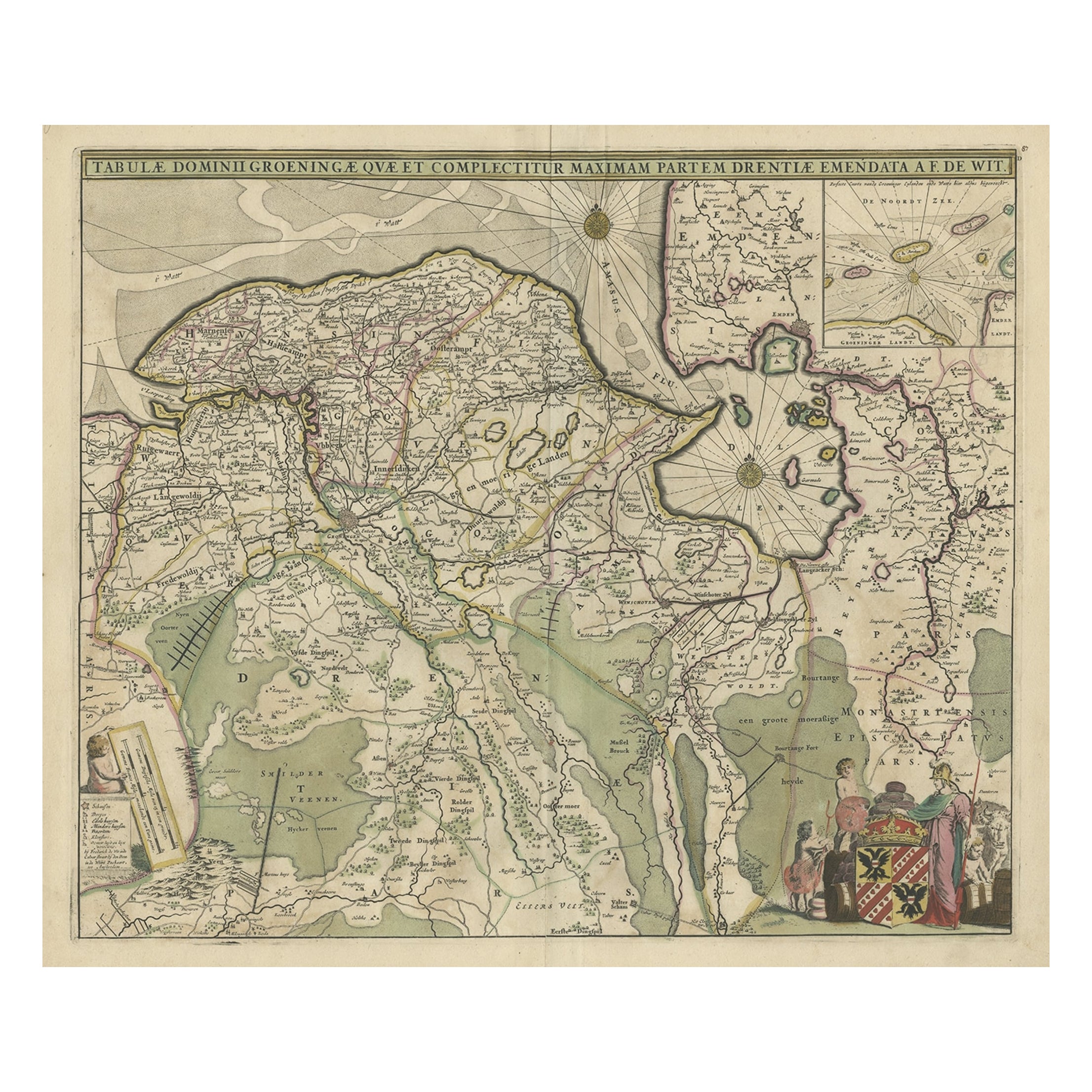
Old Map of the Province of Groningen, the Netherlands & inset of Islands, C.1680
Located in Langweer, NL
Antique map titled 'Tabulae dominii Groeningae quae et complecitur maximam partem Drentiae Emendata'.
Old map of the province of Groningen, the Netherlands. With an inset map of ...
Category
Antique 1680s Maps
Materials
Paper
$1,194 Sale Price
20% Off
Antique Map of the Province Groningen in The Netherlands, c.1680
Located in Langweer, NL
Antique map titled 'Groningae et Omlandiae Dominium vulgo de Provincie van Stadt en Lande'.
Old map of the province of Groningen, the Netherlands. This map originates from 'Germani...
Category
Antique 17th Century Maps
Materials
Paper

$470 Sale Price
20% Off
You May Also Like
1643 Willem&Joan Blaeu Map NW Flanders "Flandriae Teutonicae Pars Prientalior
Located in Norton, MA
1643 Willem and Joan Blaeu map of northwest Flanders, entitled
"Flandriae Teutonicae Pars Prientalior,"
Ric0012
" Authentic" - Map of the northwest Fl...
Category
Antique 17th Century Dutch Maps
Materials
Paper

1635 Willem Blaeu Map of Northern France"Comitatvs Bellovacvm" Ric.a08
Located in Norton, MA
1635 Willem Blaeu map of northern France, entitled.
"Comitatvs Bellovacvm Vernacule Beavvais,"
Colored
Ric.a008
“COMITATVS BELLOVACVM…” Amsterdam: W...
Category
Antique 17th Century Unknown Maps
Materials
Paper

1752 Vaugoundy Map of Flanders : Belgium, France, and the Netherlands, Ric.a002
Located in Norton, MA
Large Vaugoundy Map of Flanders:
Belgium, France, and the Netherlands
Colored -1752
Ric.a002
Description: This is a 1752 Didier Robert de Vaugondy map of Flanders. The map de...
Category
Antique 17th Century Unknown Maps
Materials
Paper

17th Century Map of Denmark by French Cartographer Sanson, Dated 1658
By Nicolas Sanson
Located in Copenhagen, K
17th century map of Denmark by French cartographer Sanson.
Nicolas Sanson (20 December 1600-7 July 1667) was a French cartographer, termed by some the creator of French geography an...
Category
Antique 17th Century French Maps
Materials
Paper

1640 Willem Blaeu Map Entitled "Contado di molise et principato vltra, " Ric.a003
By Willem Blaeu
Located in Norton, MA
1640 Willem Blaeu map entitled
"Contado di molise et principato vltra,"
Colored
Ric. a003
Measures: 38 x 49.6 cm and wide margins
DBLAEU.
Cou...
Category
Antique 17th Century Dutch Maps
Materials
Paper

1633 Map Entitled "Beauvaisis Comitatus Belova Cium, Ric.0002
Located in Norton, MA
1633 map entitled
"Beauvaisis Comitatus Belova Cium,"
Hand Colored
Ric.0002
Description: Cartographer : - Hondius, Henricus 1587-1638
Artists and Engravers:Jodocus Hondius, one of the most notable engravers of his time. He is known for his work in association with many of the cartographers and publishers prominent at the end of the sixteenth and the beginning of the seventeenth century. A native of Flanders, he grew up in Ghent, apprenticed as an instrument and globe maker and map engraver. In 1584, to escape the religious troubles sweeping the Low Countries at that time, he fled to London where he spent some years before finally settling in Amsterdam about 1593. In the London period he came into contact with the leading scientists and geographers of the day and engraved maps in The Mariner\\\\\\\\\\\\\\\'s Mirrour, the English edition of Waghenaer\\\\\\\\\\\\\\\'s Sea Atlas, as well as others with Pieter van den Keere, his brother-in-law. No doubt his temporary exile in London stood him in good stead, earning him an international reputation, for it could have been no accident that Speed chose Hondius to engrave the plates for the maps in The Theatre of the Empire of Great Britaine in the years between 1605 and 1610. In 1604 Hondius bought the plates of Mercator\\\\\\\\\\\\\\\'s Atlas which, in spite of its excellence, had not competed successfully with the continuing demand for the Ortelius Theatrum Orbis Terrarum. To meet this competition Hondius added about 40 maps to Mercator\\\\\\\\\\\\\\\'s original number and from 1606 published enlarged editions in many languages, still under Mercator\\\\\\\\\\\\\\\'s name but with his own name as publisher. These atlases have become known as the Mercator/Hondius series. The following year the maps were reengraved in miniature form and issued as a pocket Atlas Minor. After the death of Jodocus Hondius the Elder in 1612, work on the two atlases, folio and miniature, was carried on by his widow and sons, Jodocus II and Henricus, and eventually in conjunction with Jan Jansson in Amsterdam.
In all, from 1606 onwards, nearly 50 editions with increasing numbers of maps with texts in the main European languages were printed. Summaries of these issues are given under the entry for Gerard Mercator. Jodocus Hondius the Elder * 1588 Maps in The Mariner\\\\\\\\\\\\\\\'s Mirrour (Waghenaer/Ashley) * 1590 World Map...
Category
Antique 17th Century Dutch Maps
Materials
Paper

More Ways To Browse
Otto Petri
Antique Map Of Jerusalem
Iraq Map
Antique Map Of Korea
Solomons Temple
Antique Maps Caribbean Islands
Antique Wine Maps
Map Of Jamaica
Used Furniture Wisconsin
Antique Furniture Michigan
Antique Maps Of Cape Of Good Hope
Antique Maps Of Texas
Antique Virginia Furniture
Mughal Map
American West Antiques
Antique Furniture Brunswick
Antique Map Ceylon
Antique Map Of The Philippines