Items Similar to Large Italian Map of Islands of Oceania, incl Papua, Timor, Banda, Ceram, 1855


Want more images or videos?
Request additional images or videos from the seller
1 of 6
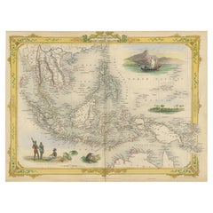
Large Italian Map of Islands of Oceania, incl Papua, Timor, Banda, Ceram, 1855
$2,538.01
$3,172.5120% Off
£1,872.17
£2,340.2220% Off
€2,120
€2,65020% Off
CA$3,516.54
CA$4,395.6820% Off
A$3,815.98
A$4,769.9820% Off
CHF 2,022.13
CHF 2,527.6720% Off
MX$46,801.16
MX$58,501.4520% Off
NOK 25,023.77
NOK 31,279.7120% Off
SEK 23,646.13
SEK 29,557.6720% Off
DKK 16,143.40
DKK 20,179.2420% Off
About the Item
Description: Antique map titled 'Carta di una parte dell'Oceania'. Beautiful large map of the (Spice) islands of Oceania. Depicting Papua, Timor, Ceram, Gilolo and many more. Source unknown, to be determined. More research to be done. Rare.
Rev. Msgr. Carlos Cuarteron (1816 – 12 March 1880) is mentioned on the Map and potentially took the initiative for the map to be presented to Allesandro Barnabo.
Carlos Cuarteron was a Spanish mariner who later became a priest and established the first Roman Catholic missions in northern Borneo. Born in Cadiz to an Italian father and Spanish mother, Carlos went to sea at the age of 13. He was based in the Philippines and built up his experience on the route between Manila and Macao until he became a full captain in 1841. By February 1844 he had bought his own 146 ton topsail schooner, Il Martiri de Tunkin, and set out to find and salvage a valuable cargo from the wreck of the Christina, which had been reported in July 1842. He succeeded, surrendered (after some delay) the treasure to its insurers in Hong Kong, and was well rewarded.
Having undertaken several voyages in the islands south and east of the Philippines during which he freed several slaves and did some evangelising he became more interested in missionary work and went back to Europe for support and training. In 1855 he was appointed Priest Apostolic to Borneo by the Pope and left for the east in 1856 with two Italian priests to assist him.
The mission was welcomed in Labuan in 1857, and also established stations in Brunei and at Looc Porin (near where Kota Kinabalu is now). However, problems with his assistants left him alone from 1860 and the mission made little progress.
Cuarteron, already ill, resigned his post in Rome in December 1879, then returned to his sister's home in Cadiz, where he died of pneumonia on 12 March 1880.
Artists and Engravers: Anonymous.
Condition: Good, minor defects from handling. Please study image carefully.
About the Seller
5.0
Recognized Seller
These prestigious sellers are industry leaders and represent the highest echelon for item quality and design.
Platinum Seller
Premium sellers with a 4.7+ rating and 24-hour response times
Established in 2009
1stDibs seller since 2017
2,622 sales on 1stDibs
Typical response time: <1 hour
- ShippingRetrieving quote...Shipping from: Langweer, Netherlands
- Return Policy
Authenticity Guarantee
In the unlikely event there’s an issue with an item’s authenticity, contact us within 1 year for a full refund. DetailsMoney-Back Guarantee
If your item is not as described, is damaged in transit, or does not arrive, contact us within 7 days for a full refund. Details24-Hour Cancellation
You have a 24-hour grace period in which to reconsider your purchase, with no questions asked.Vetted Professional Sellers
Our world-class sellers must adhere to strict standards for service and quality, maintaining the integrity of our listings.Price-Match Guarantee
If you find that a seller listed the same item for a lower price elsewhere, we’ll match it.Trusted Global Delivery
Our best-in-class carrier network provides specialized shipping options worldwide, including custom delivery.More From This Seller
View AllAntique Map of the East Indies by Van der Aa '1849'
Located in Langweer, NL
Antique map titled 'Kaart van Nederlands OostIndie door A.J. van der Aa'. Old map of the Dutch East Indies. This map originates from 'Nederlands Oost-Indië, of beschrijving der Neder...
Category
Antique Mid-19th Century Maps
Materials
Paper

$383 Sale Price
20% Off
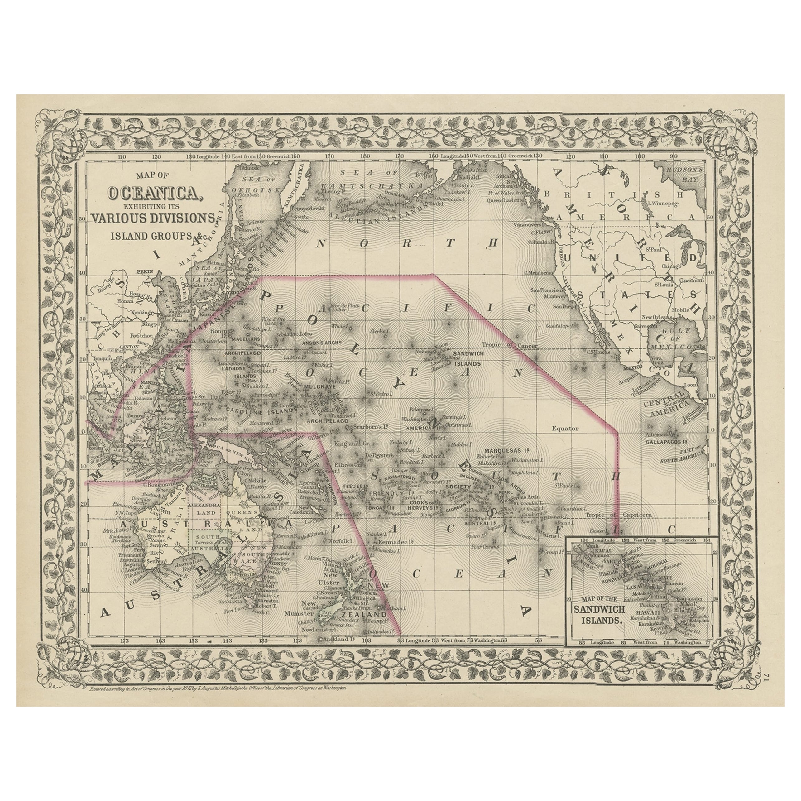
Old Map of the Pacific, Incl Australia, Polynesia, Melanesia and Malaysia, 1872
Located in Langweer, NL
Antique map Oceania titled 'Map of Oceanica exhibiting its various divisions, island groups & c'.
Map of the Pacific, including Australia, Polynes...
Category
Antique 1870s Maps
Materials
Paper
$181 Sale Price
20% Off
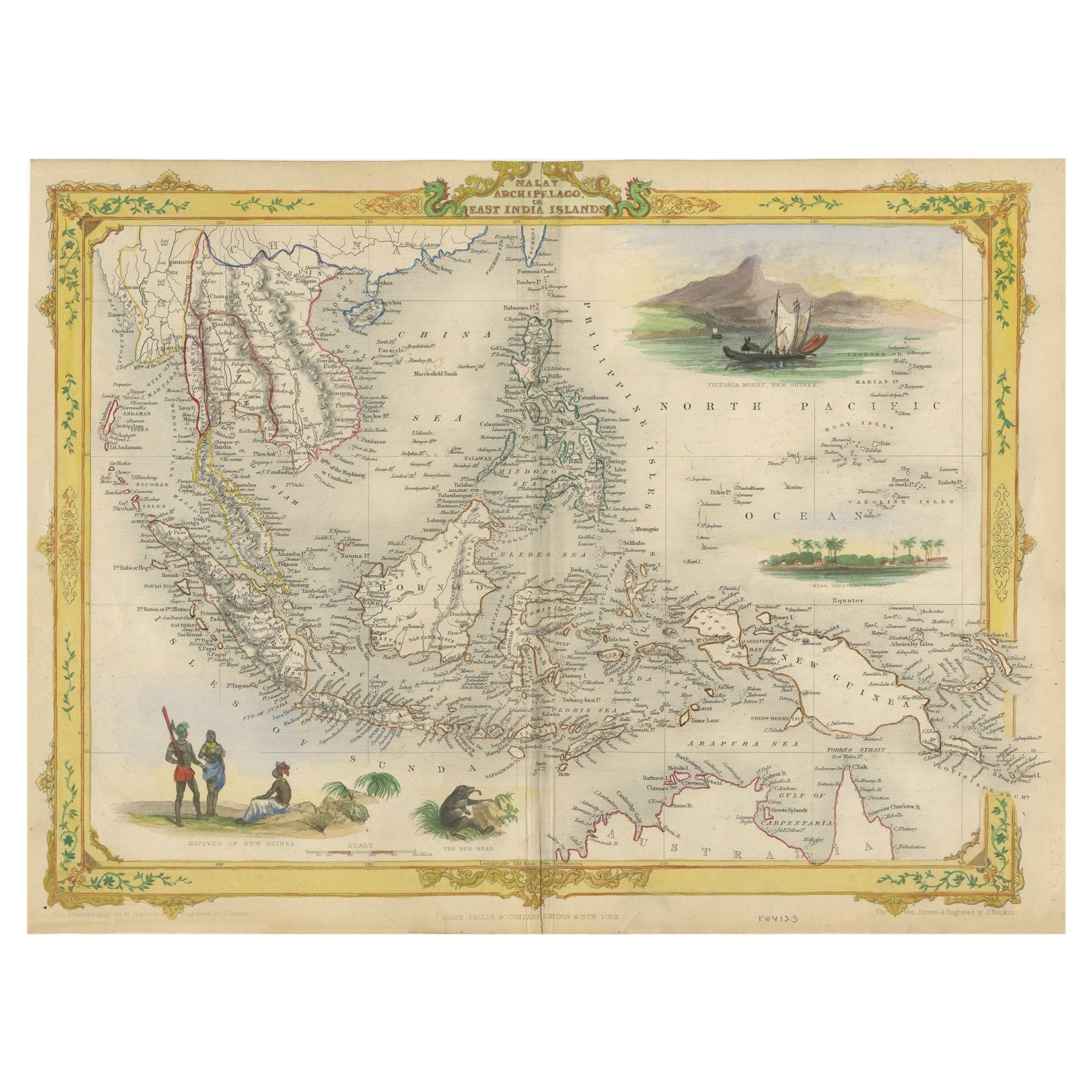
Decorative Antique Map of the Malay Archipelago or East Indies Island, 1851
Located in Langweer, NL
Antique map Indonesia titled 'Malay Archipelago, or East India Islands'. With vignettes of Victoria Mount, New Guinea, Nativaes of New Guinea an...
Category
Antique 1850s Maps
Materials
Paper
$1,053 Sale Price
20% Off
Antique Map of the East Indies by Walker, c.1840
Located in Langweer, NL
Original antique map of the East Indies including Borneo, Celebes, Java, Sumatra and surrounding islands. Published circa 1840.
Artists and Engravers: Engraved by J. & C. Walker
...
Category
Antique 19th Century Maps
Materials
Paper

$229 Sale Price
20% Off
Antique Map of the Islands in the Pacific Ocean by Wyld, '1845'
Located in Langweer, NL
Antique map titled 'Islands in the Pacific Ocean'. Original antique map of the islands in the Pacific Ocean. This map originates from 'An Atlas of the World, Comprehending Separate M...
Category
Antique Mid-19th Century Maps
Materials
Paper

$191 Sale Price
20% Off
Antique Map of Polynesia and Australasia by Neele, 1825
Located in Langweer, NL
Antique map titled 'Polynesia and Australasia'. It shows Australia (New Holland), part of Asia, New Zealand and many islands. This map originates from 'Encyclopedia Londinensis'.
Category
Antique Early 19th Century Maps
Materials
Paper

$114 Sale Price
20% Off
You May Also Like
Large Original Vintage Map of The Pacific Islands Including Hawaii
Located in St Annes, Lancashire
Great map of The Pacific Islands
Unframed
Original color
By John Bartholomew and Co. Edinburgh Geographical Institute
Published, circa 1...
Category
Vintage 1920s British Maps
Materials
Paper

Large Original Antique Map of The Pacific Ocean, Fullarton, C.1870
Located in St Annes, Lancashire
Great map of The Pacific Ocean
From the celebrated Royal Illustrated Atlas
Lithograph by Swanston. Original color.
Published by Fullarton,...
Category
Antique 1870s Scottish Maps
Materials
Paper

Original Antique Map of South East Asia by Thomas Clerk, 1817
Located in St Annes, Lancashire
Great map of South East Asia
Copper-plate engraving
Drawn and engraved by Thomas Clerk, Edinburgh.
Published by Mackenzie And Dent, 1817
Unframed.
Category
Antique 1810s English Maps
Materials
Paper

Large Original Antique Map of Java and Borneo, Fullarton, C.1870
Located in St Annes, Lancashire
Great map of Java and Borneo
Wonderful figurative borders
From the celebrated Royal Illustrated Atlas
Lithograph. Original color.
Published by Fullarton, Edinburgh. C.1870
Unfr...
Category
Antique 1870s Scottish Maps
Materials
Paper

Original Antique Map of US Possessions In The Pacific Ocean, C.1900
Located in St Annes, Lancashire
Fabulous map of US possessions in the Pacific Ocean
Original color.
Engraved and printed by the George F. Cram Company, Indianapolis.
Published, C.1900.
Unframed.
Free shipping.
Category
Antique 1890s American Maps
Materials
Paper

Large Original Antique Map of Australia by Sidney Hall, 1847
Located in St Annes, Lancashire
Great map of Australia
Drawn and engraved by Sidney Hall
Steel engraving
Original colour outline
Published by A & C Black. 1847
Unframed
Free shipping.
Category
Antique 1840s Scottish Maps
Materials
Paper

More Ways To Browse
Antique Schooner
Large Map Of Italy
Map Of Middle East
17th Century American Furniture
Afghanistan Map
Antique Celestial Maps
Antique Maps Virginia
Hand Drawn Map
Map Of Israel
Map Of Poland
Sicily Map
Used Durham Furniture
Antique Maps Of Israel
Antique Maps Of Russian Empire
J C Walker Map
Massachusetts Antiques
Persian Maps
Afghanistan Antique Map