Items Similar to Map of the Circle of Franconia, Germany Bamberg, Wurtzburg and Nuremberg, 1757


Want more images or videos?
Request additional images or videos from the seller
1 of 5
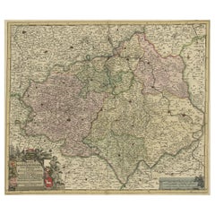
Map of the Circle of Franconia, Germany Bamberg, Wurtzburg and Nuremberg, 1757
$525.84
$657.3020% Off
£389.28
£486.6020% Off
€440
€55020% Off
CA$727.63
CA$909.5320% Off
A$802.07
A$1,002.5920% Off
CHF 419.68
CHF 524.6020% Off
MX$9,841.14
MX$12,301.4220% Off
NOK 5,282.95
NOK 6,603.6920% Off
SEK 4,940.39
SEK 6,175.4920% Off
DKK 3,350.16
DKK 4,187.7020% Off
About the Item
Antique map titled 'Cercle de Franconie (..)'.
Map of the Circle of Franconia, Germany. Centered on Bamberg, Wurtzburg and Nuremberg. This map originates from 'Atlas Universel (..)'.
Artists and Engravers: Gilles Robert de Vaugondy (1688 - 1766), also known as Le Sieur or Monsieur Robert, and his son, Didier Robert de Vaugondy (c.1723 - 1786), were leading mapmakers in France during the 18th century. In 1757, they published The Atlas Universel, one of the most important atlases of the 18th century. To produce the atlas, the Vaugondys integrated older sources with more modern surveyed maps. They verified and corrected the latitude and longitude of many regional maps in the atlas with astronomical observations. The older material was revised with the addition of many new place names. In 1760, Didier Robert de Vaugondy was appointed geographer to Louis XV.
Condition: Fair/good, general age-related tonign. Original folding line, with repair. Minor wear and small defects, blank verso. Please study image carefully.
- Dimensions:Height: 22.05 in (56 cm)Width: 27.17 in (69 cm)Depth: 0 in (0.02 mm)
- Materials and Techniques:
- Period:1750-1759
- Date of Manufacture:1757
- Condition:Repaired: Original folding line with repair. Wear consistent with age and use. Condition: Fair/good, general age-related tonign. Original folding line, with repair. Minor wear and small defects, blank verso. Please study image carefully.
- Seller Location:Langweer, NL
- Reference Number:Seller: BG-12674-31stDibs: LU3054326752762
About the Seller
5.0
Recognized Seller
These prestigious sellers are industry leaders and represent the highest echelon for item quality and design.
Platinum Seller
Premium sellers with a 4.7+ rating and 24-hour response times
Established in 2009
1stDibs seller since 2017
2,615 sales on 1stDibs
Typical response time: <1 hour
- ShippingRetrieving quote...Shipping from: Langweer, Netherlands
- Return Policy
Authenticity Guarantee
In the unlikely event there’s an issue with an item’s authenticity, contact us within 1 year for a full refund. DetailsMoney-Back Guarantee
If your item is not as described, is damaged in transit, or does not arrive, contact us within 7 days for a full refund. Details24-Hour Cancellation
You have a 24-hour grace period in which to reconsider your purchase, with no questions asked.Vetted Professional Sellers
Our world-class sellers must adhere to strict standards for service and quality, maintaining the integrity of our listings.Price-Match Guarantee
If you find that a seller listed the same item for a lower price elsewhere, we’ll match it.Trusted Global Delivery
Our best-in-class carrier network provides specialized shipping options worldwide, including custom delivery.More From This Seller
View AllAntique Map of the Circle of Franconia, 1757
Located in Langweer, NL
Antique map titled 'Cercle de Franconie (..)'. Map of the Circle of Franconia, Germany. Centered on Bamberg, Wurtzburg and Nuremberg. This map originates from 'Atlas Universel (..)'....
Category
Antique 18th Century Maps
Materials
Paper
$650 Sale Price
20% Off
Antique Map of the Saxony Region 'Germany' by F. de Wit, circa 1680
Located in Langweer, NL
A detailed map of a region in eastern Germany. Cartouches depict coat of arms surrounded by cherubs. The map is fully engraved with towns, political boundaries, rivers and forests. P...
Category
Antique Late 17th Century Dutch Maps
Materials
Paper

Antique Map of Lower Saxony in Germany, c.1740
Located in Langweer, NL
Antique map titled 'Nieuwe Kaart van de Neder Saxise Kreits (..).' Attractive detailed map showing Lower Saxony, Germany, including Mekelenburg, Lauwenburg, Holstein, Bremen, Verden ...
Category
Antique 18th Century Maps
Materials
Paper

$525 Sale Price
20% Off
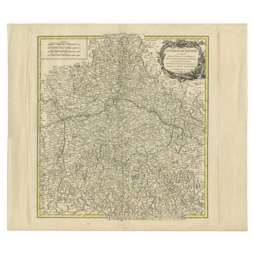
Antique Map of the Circle of Bavaria by Vaugondy, 1757
Located in Langweer, NL
Antique map titled 'Le Cercle de Baviere (..)'. Map of the Circle of Bavaria, Germany. Extends from Bamberg to Innsbruck. This map originates from 'Atlas Universel (..)'. Artists and Engravers: Gilles Robert de Vaugondy (1688 - 1766), also known as Le Sieur or Monsieur Robert, and his son, Didier Robert de Vaugondy (c.1723 - 1786), were leading mapmakers in France during the 18th century. In 1757, they published The Atlas Universel, one of the most important atlases of the 18th century. To produce the atlas, the Vaugondys integrated older sources with more modern surveyed maps...
Category
Antique 18th Century Maps
Materials
Paper
$190 Sale Price
20% Off
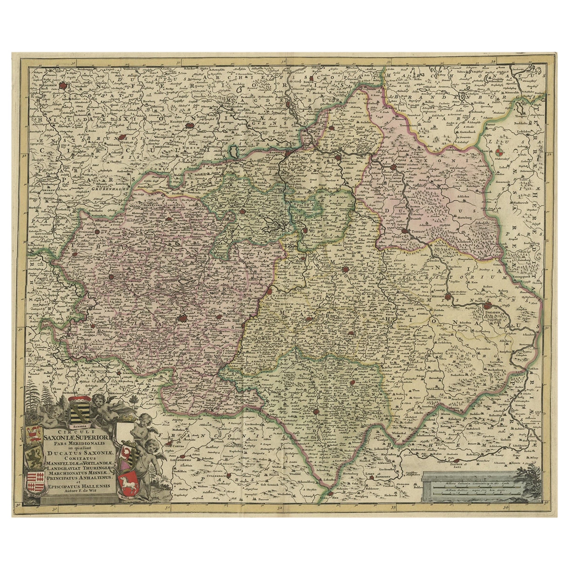
Old Detailed Map of the Historical Regions of the Duchy of Saxony, Germany, 1680
Located in Langweer, NL
Antique map titled 'Circuli Saxoniae Superior Pars Meridionalis in qua sunt Ducatus Saxoniae, Comitatus Mansfeldiae, et Voitlandiae, Landgraviat Thuringiae, Marchionatus Misniae Prin...
Category
Antique 1680s Maps
Materials
Paper
$688 Sale Price
20% Off
Antique Map of Southern Germany by F. de Wit, circa 1680
Located in Langweer, NL
This antique map depicts a portion of southern Germany that included the historic regions of Bavaria, the Palatinate, Prussia-Brandenburg, the Rhineland and Saxony. Regensberg, Freis...
Category
Antique Late 17th Century Maps
Materials
Paper

$664 Sale Price
20% Off
You May Also Like
1752 Vaugoundy Map of Flanders : Belgium, France, and the Netherlands, Ric.a002
Located in Norton, MA
Large Vaugoundy Map of Flanders:
Belgium, France, and the Netherlands
Colored -1752
Ric.a002
Description: This is a 1752 Didier Robert de Vaugondy map of Flanders. The map de...
Category
Antique 17th Century Unknown Maps
Materials
Paper

1853 Map of "Russia in Europe Including Poland" Ric.r016
Located in Norton, MA
Description
Russia in Europe incl. Poland by J Wyld c.1853
Hand coloured steel engraving
Dimension: Paper: 25 cm W x 33 cm H ; Sight: 22 cm W x 28 cm H
Condition: Good ...
Category
Antique 19th Century Unknown Maps
Materials
Paper

1771 Bonne Map of Poitou, Touraine and Anjou, France, Ric.a015
Located in Norton, MA
1771 Bonne Map of Poitou,
Touraine and Anjou, France
Ric.a015
1771 Bonne map of Potiou, Touraine and Anjou entitled "Carte des Gouvernements D'Anjou et du Saumurois, de la Touraine, du Poitou,du Pays d'aunis, Saintonge?Angoumois,"
Carte des gouvernements d'Anjou et du Saumurois, de la Touraine, du Poitou, du Pays d'Aunis, Saintonge-Angoumois. Projettee et assujettie au ciel par M. Bonne, Hyd. du Roi. A Paris, Chez Lattre, rue St. Jacques a la Ville de Bord(ea)ux. Avec priv. du Roi. 1771. Arrivet inv. & sculp., Atlas moderne ou collection de cartes sur toutes...
Category
Antique 17th Century Unknown Maps
Materials
Paper

Map of the War -Vesfaglia and Lower Saxony - Etching - 19th Century
Located in Roma, IT
Map of the War -Vestaglia and Lower Saxony is an etching realized during the 19th century.
Good condition.
Category
Early 19th Century Modern Figurative Prints
Materials
Etching

18th Century Emanuel Bowen Map of County of York, c.1740
By Emanuel Bowen
Located in Royal Tunbridge Wells, Kent
Antique 18th century British rare and original Emanuel Bowen (1694-1767) map of the County of York divided into its Ridings and subdivided into wapontakes, mounted in solid wood fram...
Category
Antique Early 18th Century British Maps
Materials
Paper

West Germany: Original Hand Colored 17th Century Map by Johannes Janssonius
By Johannes Janssonius
Located in Alamo, CA
An original hand colored copperplate engraved map entitled in Latin "Archiepiscopatus Maghdeburgensis et Anhaltinus Ducatus cum terris adjacentibus", published in Amsterdam in 1640 i...
Category
Mid-17th Century Old Masters More Prints
Materials
Engraving

More Ways To Browse
Artist Gill
Solomons Temple
Antique Maps Caribbean Islands
Antique Wine Maps
Map Of Jamaica
Used Furniture Wisconsin
Antique Furniture Michigan
Antique Maps Of Cape Of Good Hope
Antique Maps Of Texas
Antique Virginia Furniture
Mughal Map
American West Antiques
Antique Furniture Brunswick
Antique Map Ceylon
Antique Map Of The Philippines
Antique Mississippi Map
Celestial Map
Nevada Antique Map