Items Similar to Map Holy Promise Land Canaan Richard Palmer Richard Blome 1687 Joseph Moxon

Want more images or videos?
Request additional images or videos from the seller
1 of 7
Map Holy Promise Land Canaan Richard Palmer Richard Blome 1687 Joseph Moxon
$4,133.45
£3,000
€3,526.31
CA$5,719.66
A$6,305.79
CHF 3,298.99
MX$77,360.38
NOK 41,527.72
SEK 38,834.99
DKK 26,334.61
About the Item
Canaan comonly called the Holy Land or the Land of Promise, being the Possesion of the Israelites & travelled through by Our Lord & Saviour Iesus Christ and his Apostles. Engraven by Richard Palmer for Richard Blome. 1687
Blome, Richard, 1641-1705. London. 283 x 452 mm. Copperplate.
Probably from an English Bible, end of the 17th century.
The map is an exact copy of Nicolaes Visscher's map, with Joseph Moxon's alterations ommiting the title cartouche id at top centre and the decorations.
Bearing Baynton-Williams label, dealer old maps
The map length 46cm., 18" height 26cm., 10 1/4"
In a black and gold frame length 50cm., 19 1/2 " height 31cm., 12 1/2".
- Dimensions:Height: 12.21 in (31 cm)Width: 19.69 in (50 cm)Depth: 0.4 in (1 cm)
- Style:Baroque (Of the Period)
- Materials and Techniques:
- Place of Origin:
- Period:
- Date of Manufacture:1687
- Condition:Wear consistent with age and use.
- Seller Location:BUNGAY, GB
- Reference Number:1stDibs: LU3867332075872
About the Seller
5.0
Vetted Professional Seller
Every seller passes strict standards for authenticity and reliability
Established in 1985
1stDibs seller since 2018
99 sales on 1stDibs
Typical response time: 9 hours
- ShippingRetrieving quote...Shipping from: BUNGAY, United Kingdom
- Return Policy
Authenticity Guarantee
In the unlikely event there’s an issue with an item’s authenticity, contact us within 1 year for a full refund. DetailsMoney-Back Guarantee
If your item is not as described, is damaged in transit, or does not arrive, contact us within 7 days for a full refund. Details24-Hour Cancellation
You have a 24-hour grace period in which to reconsider your purchase, with no questions asked.Vetted Professional Sellers
Our world-class sellers must adhere to strict standards for service and quality, maintaining the integrity of our listings.Price-Match Guarantee
If you find that a seller listed the same item for a lower price elsewhere, we’ll match it.Trusted Global Delivery
Our best-in-class carrier network provides specialized shipping options worldwide, including custom delivery.More From This Seller
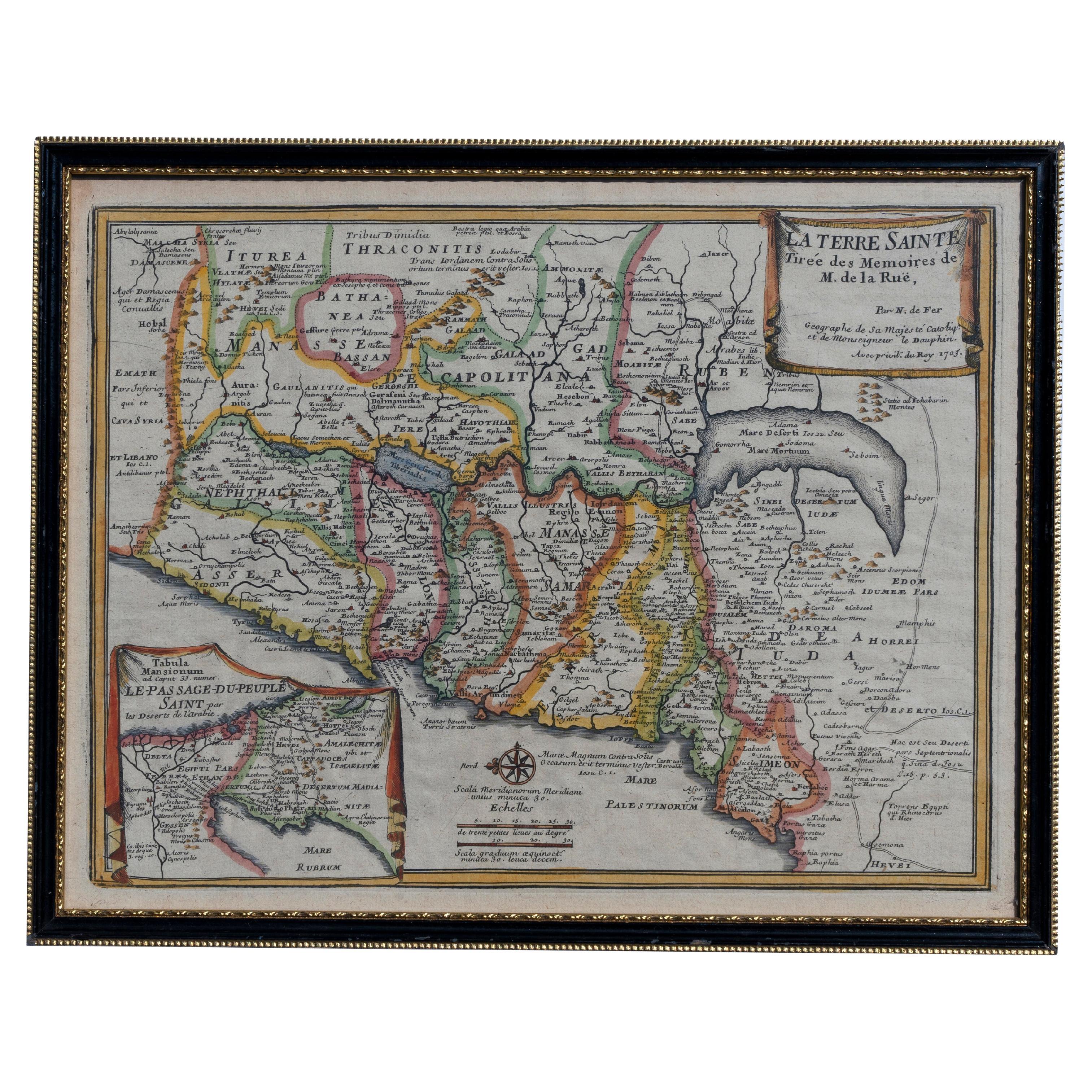
View AllMap Holy Land La Terre Sainte Engraved van Loon Published N de Fer 1703 French
Located in BUNGAY, SUFFOLK
La Terre Sainte, The Holy Land, Tiree Des Memoires De M.De.La Rue. Par N. de Fer. Geographe de Sa Majeste Catoliq et de Monseigneur le Dauphin. Avec Privil du Roi 1703
Detailed map of the Holy Land from Nicholas de Fer's L'Atlas Curieux ou le Monde. East is oriented at the top.
MAKER Nicolas de Fer 1646-1720
The French cartographer and engraver, Nicolas de Fer, was a master at creating maps that were works of art. The maps that he published were printed during the Baroque period when the decorative arts were characterized by ornate detail. De Fer’s detailed maps and atlases were valued more for their decorative content than their geographical accuracy.
Nicolas de Fer was born in 1646. His father, Antoine de Fer, owned a mapmaking firm. At the age of twelve, Nicolas was apprenticed to a Parisian engraver named Louis Spirinx. The family business was starting to decline when his father died in 1673. Nicolas de Fer’s mother, Genevieve, took over the business after the death of her husband. In 1687 the business was passed on to Nicolas and the profits increased after he took over the firm. Nicolas de Fer was a prolific cartographer who produced atlases and hundreds of single maps. He eventually became the official geographer to King Louis XIV of France and King Philip V...
Category
Antique Early 1700s French Louis XIV Maps
Materials
Paper

Map Southern Scotland Thomas Conder Alex Hogg 1795
Located in BUNGAY, SUFFOLK
A new map of the southern part of Scotland containing the counties of Stirling, Lanerk, Renfrew, Linlithgow, Edinburgh, Peebles, Haddingtoun, Berwick, Selkirk, Roxburgh, Dumfries, Wigtoun, Kirkudbright & Air
Published by Alex Hogg at the Kings Arms...
Category
Antique 18th Century English Georgian Maps
Materials
Paper

Map Kyle Carrick Aireshire Thomas Kitchen 1749
By Thomas Kitchin
Located in BUNGAY, SUFFOLK
A Map of Kyle & Carrick Aireshire Thomas Kitchen 1749
In original black and gold frame
Just purchased more information to follow
MAKER Thomas Kitchin (1718-1784) English engrave...
Category
Antique 18th Century English Georgian Maps
Materials
Paper

Buckingham Both Shyre and Shire John Speed 1610 Gilded Frame
Located in BUNGAY, SUFFOLK
Just purchased more information to follow.
In unrestored condition, the sheet can be cleaned.
Category
Antique 17th Century English Baroque Maps
Materials
Paper
Map Nottinghamshire Worksop Manor Newstead Abbey Nottingham Castle Shields H37cm
Located in BUNGAY, SUFFOLK
Map of Nottinghamshire with engravings of Worksop Manor Nottingham Castle Newstead Abbey
BIBLIOGRAPHY published in Barclay's Universal English Dicti...
Category
Antique 19th Century English Victorian Maps
Materials
Paper
Road Map, John Ogilby, London, Barwick, York, Chester, Darlington, Durham Framed
By John Ogilby
Located in BUNGAY, SUFFOLK
The continuation of the road from London to Barwick beginning at York and extending to Chester in ye Street. Plate ye 4th continuing 76 ½ miles. No 8.
York to Burrowbridge, to Top...
Category
Antique 1670s English Baroque Maps
Materials
Paper

You May Also Like
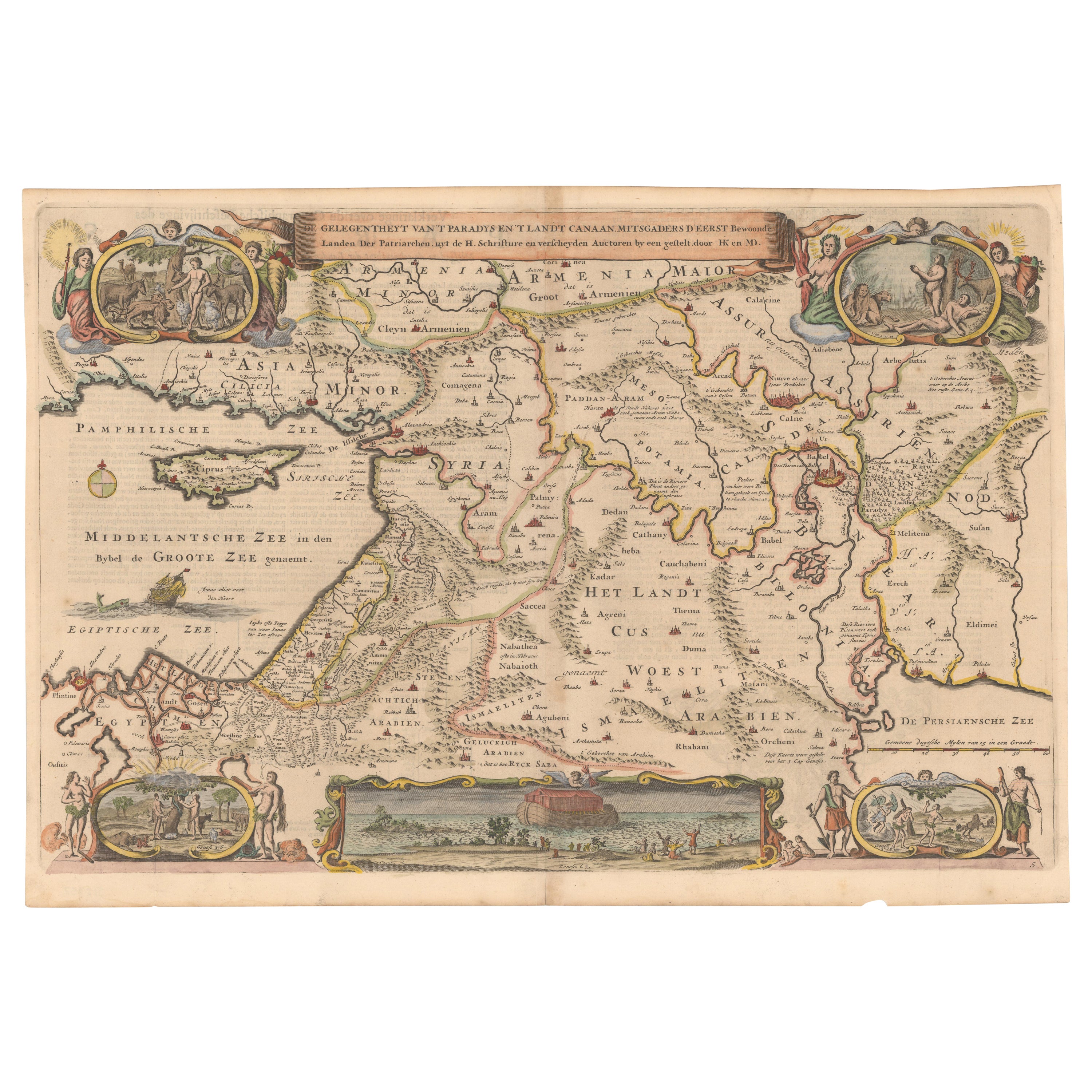
Circa 1686 Daniel Stoopendaal Map: Biblical Sites from Paradise to Canaan
Located in Langweer, NL
Circa 1686 Daniel Stoopendaal Map: Biblical Sites from Paradise to Canaan
This circa 1686 hand-colored map by Daniel Stoopendaal, titled "De Gelegentheyt van 't Paradys en 't Landt Canaan," beautifully illustrates the Middle East, extending from the Mediterranean to the Persian Gulf.
The map features numerous Biblical locations, such as the Garden of Eden, the wanderings of the Children of Israel, and the story of Jonas and the whale.
It is adorned with elaborate decorations, including a banner-style title cartouche and four corner vignettes depicting scenes from Genesis: Paradise, the creation of Adam and Eve, Eve offering the apple, and their expulsion from Eden.
The bottom center showcases a dramatic portrayal of Noah's Ark. Measuring 18.3 inches wide by 11.9 inches high, this first state map includes Dutch text on the reverse and is in good condition, with a crisp impression, light toning along the centerfold, and a small chip in the bottom margin.
Keywords:
- Daniel Stoopendaal map
- Biblical map
- Garden of Eden
- Land of Canaan
- Middle East historical map
- Noah's Ark map
- Adam and Eve
- 17th-century Bible...
Category
Antique 1680s Maps
Materials
Paper
$803 Sale Price
20% Off
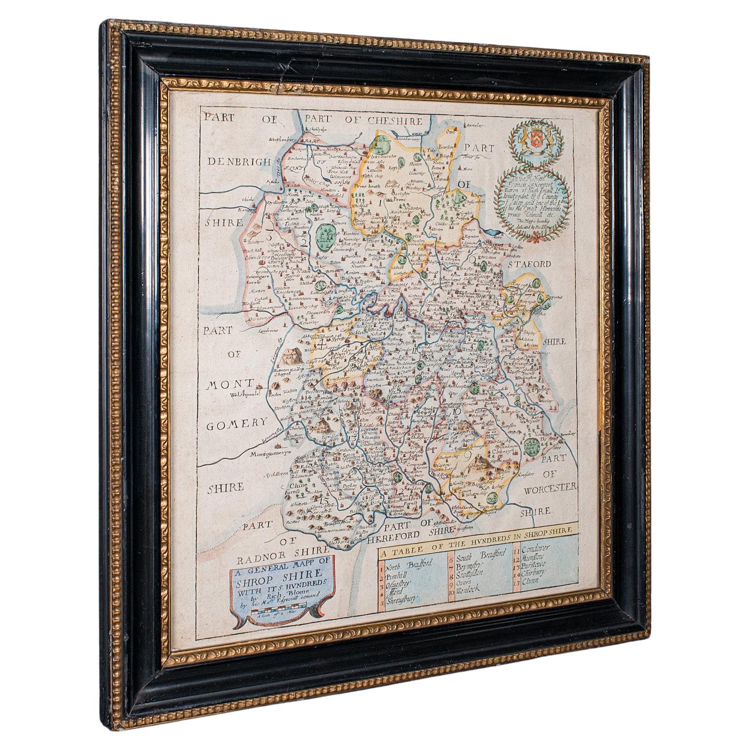
Antique County Map, Shropshire, English, Atlas Engraving, Richard Blome, C.1673
Located in Hele, Devon, GB
This is an antique county map of Shropshire. An English, framed atlas engraving by Richard Blome, dating to the 17th century and later.
A treat for the collector or county native, ...
Category
Antique 17th Century British Restauration Maps
Materials
Glass, Wood, Paper

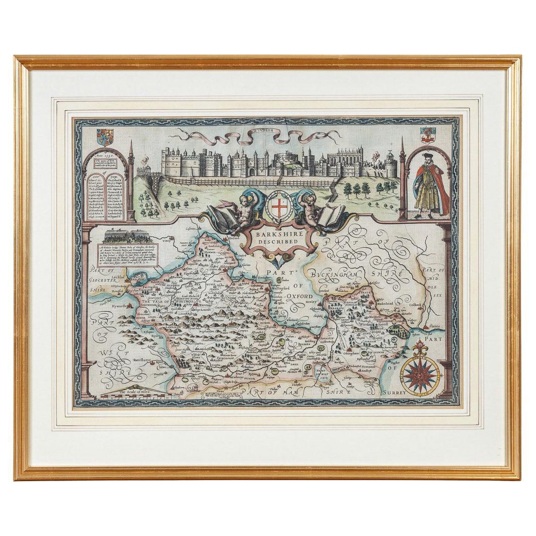
17th Century John Speed Map of the Barkshire Described, c.1616
By John Speed
Located in Royal Tunbridge Wells, Kent
Antique 17th century British very rare and original John Speed (1551-1629) map of the Barkshire Described, J. Sud and Georg Humble, publication (1616 or lat...
Category
Antique 17th Century British Maps
Materials
Paper

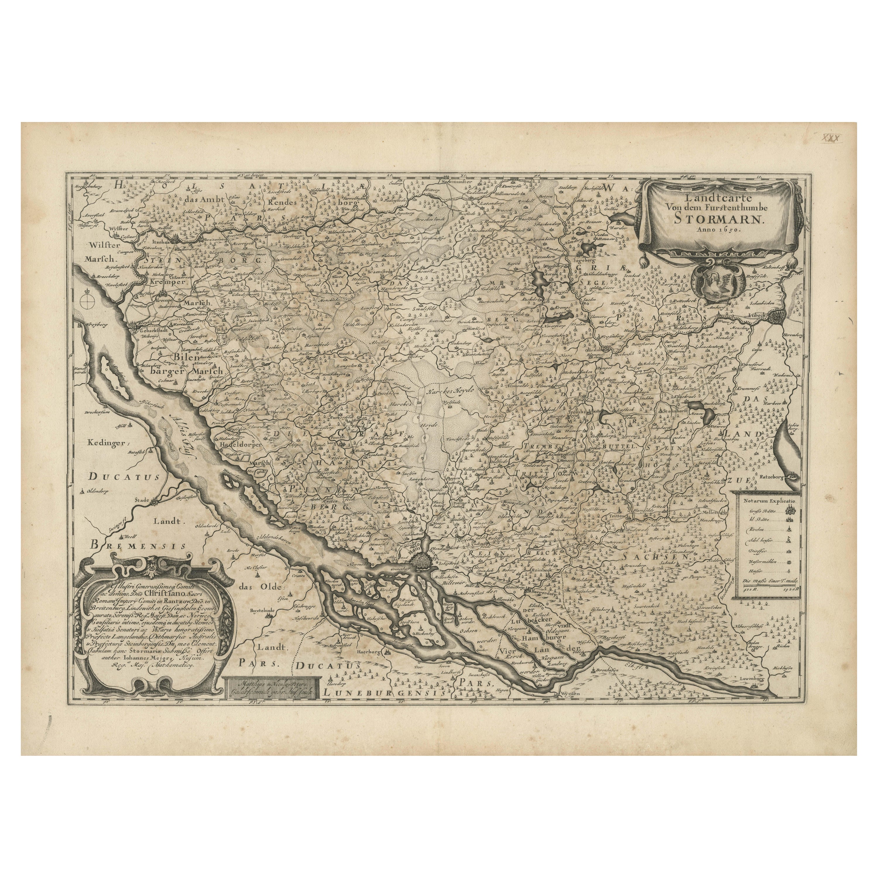
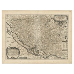
Mapping Stormarn: Johannes Meier's 1650 Cartographic Masterpiece
Located in Langweer, NL
This detailed description enhances our understanding of the historical map titled "Landtcarte von dem Furstenthumbe Stormarn," a copper etching by Johannes Meier (Mejer), dated to 16...
Category
Antique 1650s Maps
Materials
Paper
$593 Sale Price
20% Off
17th Century Nicolas Visscher Map of Southeastern Europe
Located in Hamilton, Ontario
A beautiful, highly detailed map of southeastern Europe by Nicolas Visscher. Includes regions of Northern Italy (showing the cities Bologna, Padua, and Venice), Bohemia, Austria (sho...
Category
Antique 17th Century Dutch Maps
Materials
Paper

$1,350 Sale Price
38% Off
Vintage Reproduction 17th Century Map of Europe, American, Cartography, Blaeuw
Located in Hele, Devon, GB
This is a vintage reproduction map of Europe. An American, paper stock cartography print in frame after the work by Blaeuw, dating to the late 20t...
Category
Late 20th Century Central American Mid-Century Modern Maps
Materials
Glass, Wood, Paper

More Ways To Browse
Black And Gold Frame
The Holy Bible
English Bible
Antique English Bible
Hudson River Map
Mauritius Antique Map
Nova Hollandia
Used Furniture Cleveland Ohio
Vintage Bartholomew Maps
1820 World Map
Aden Yemen
Antique Map New Orleans
Dakota Johnson
French School Map
Miliens S
Ruben Benjamin
Washington Dc Map
Wood Carved Golfer