Items Similar to Old Map of the Alsace 'Elzas' Region with Lotharingen 'Lorraine', France, c1650


Want more images or videos?
Request additional images or videos from the seller
1 of 6
Old Map of the Alsace 'Elzas' Region with Lotharingen 'Lorraine', France, c1650
$421.30
$526.6220% Off
£310.77
£388.4620% Off
€352
€44020% Off
CA$583.73
CA$729.6620% Off
A$633.82
A$792.2720% Off
CHF 335.65
CHF 419.5720% Off
MX$7,768.77
MX$9,710.9620% Off
NOK 4,153.83
NOK 5,192.2820% Off
SEK 3,925.15
SEK 4,906.4320% Off
DKK 2,679.73
DKK 3,349.6620% Off
About the Item
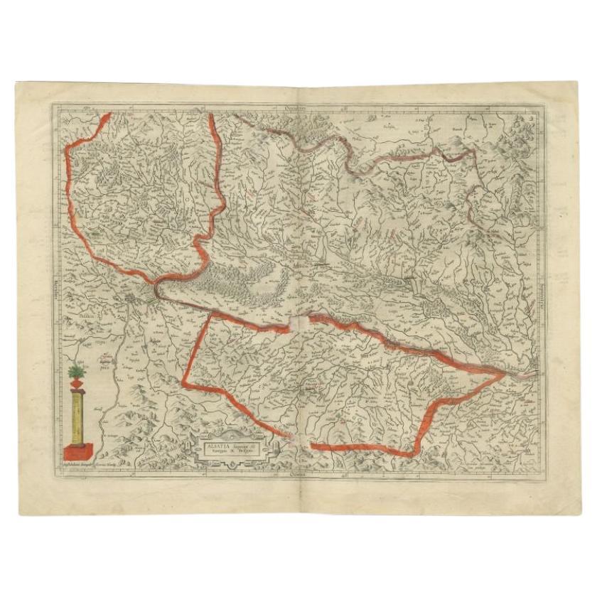
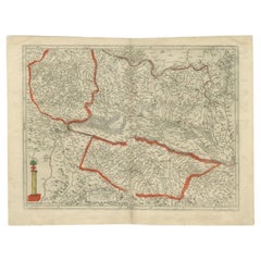
Antique map titled 'Alsatia superior cum Suntgoia et Brisgoia'.
Old map of the Alsace (or Elzas) region with Lotharingen (Lorraine), Strassburg, Freiburg, Basel etc. Source unknown, to be determined.
Artists and Engravers: Johannes Janssonius (Jansson), ( 1588- 1664) Amsterdam was born in Arnhem, the son of Jan Janszoon the Elder, a publisher and bookseller.
- Dimensions:Height: 19.69 in (50 cm)Width: 23.04 in (58.5 cm)Depth: 0 in (0.02 mm)
- Materials and Techniques:
- Period:1650-1659
- Date of Manufacture:circa 1650
- Condition:Wear consistent with age and use. Condition: Good, original/contemporary hand coloring. General age-related toning and some wear. Dutch text on verso, please study image carefully.
- Seller Location:Langweer, NL
- Reference Number:Seller: BG-112621stDibs: LU3054327514472
About the Seller
5.0
Recognized Seller
These prestigious sellers are industry leaders and represent the highest echelon for item quality and design.
Platinum Seller
Premium sellers with a 4.7+ rating and 24-hour response times
Established in 2009
1stDibs seller since 2017
2,623 sales on 1stDibs
Typical response time: <1 hour
- ShippingRetrieving quote...Shipping from: Langweer, Netherlands
- Return Policy
Authenticity Guarantee
In the unlikely event there’s an issue with an item’s authenticity, contact us within 1 year for a full refund. DetailsMoney-Back Guarantee
If your item is not as described, is damaged in transit, or does not arrive, contact us within 7 days for a full refund. Details24-Hour Cancellation
You have a 24-hour grace period in which to reconsider your purchase, with no questions asked.Vetted Professional Sellers
Our world-class sellers must adhere to strict standards for service and quality, maintaining the integrity of our listings.Price-Match Guarantee
If you find that a seller listed the same item for a lower price elsewhere, we’ll match it.Trusted Global Delivery
Our best-in-class carrier network provides specialized shipping options worldwide, including custom delivery.More From This Seller
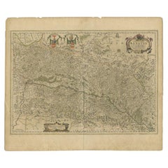
View AllAntique Map of the Alsace Region of France by Hondius, c.1630
Located in Langweer, NL
Antique map titled 'Alsatia Superior (..)'. Original antique map of the Alsace (Elzas) region of France. The map is centered on the course of the Rhine River, from Strasbourg in the north to Basle. Artists and Engravers: Published by H. Hondius. Henricus Hondius...
Category
Antique 17th Century Maps
Materials
Paper
$243 Sale Price
20% Off
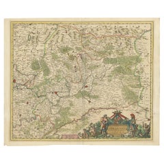
Antique Map of the Region of Franche-Comté by Janssonius, circa 1650
Located in Langweer, NL
Antique map titled 'Burgundiae Comitatus Franche Comté'. Old map of the historical and former region of Franche-Comté, France. As a region, it encompasse...
Category
Antique Mid-17th Century Maps
Materials
Paper

$574 Sale Price
20% Off
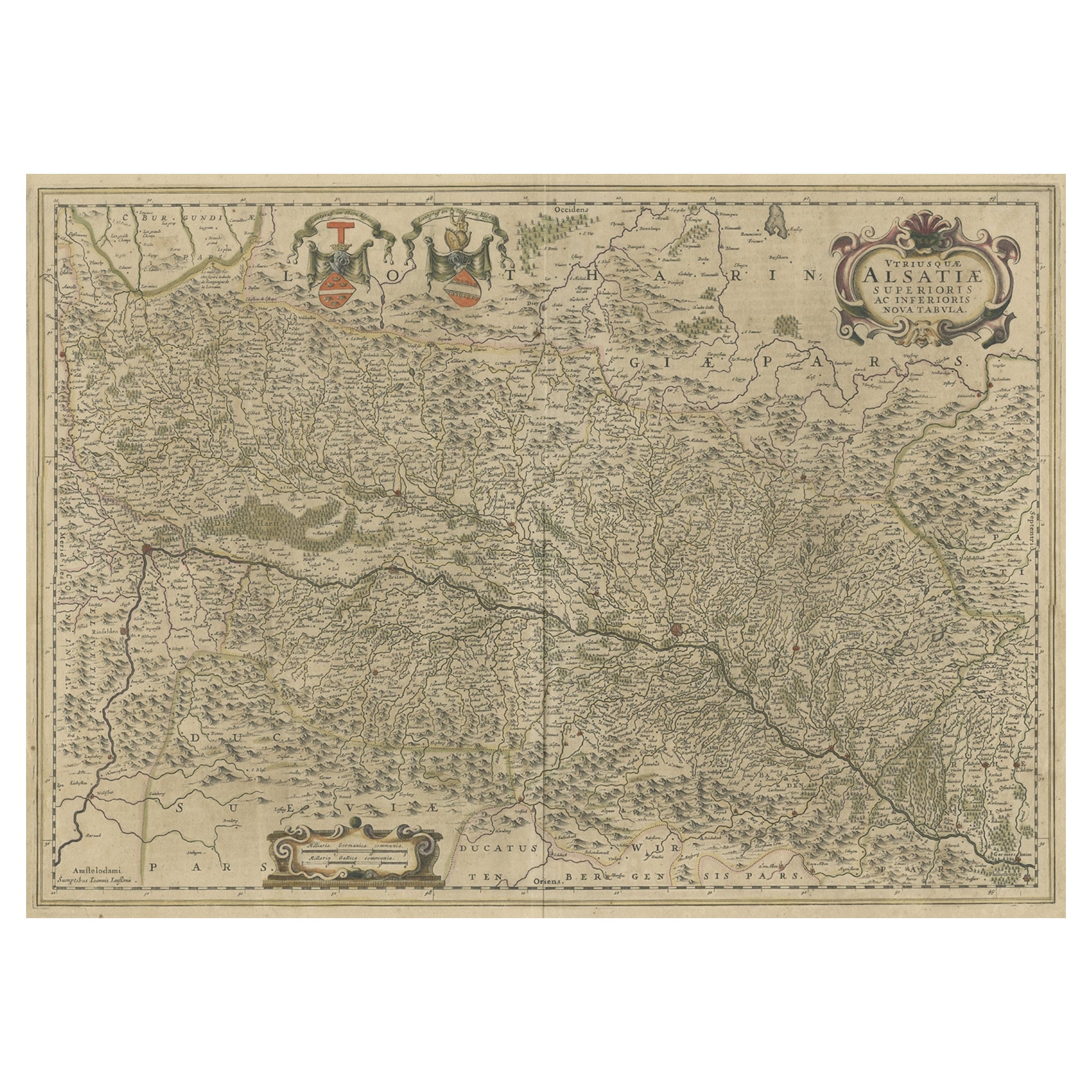
Antique Map of the Alsace Region of France by Janssonius, c.1650
Located in Langweer, NL
Antique map titled 'Utriusquae Alsatiae Superioris Ac Inferioris Nova Tabula'. Map of the Alsace region (France) including the Rhine from Phillipsburg to south of Basle. Two decorati...
Category
Antique 17th Century Maps
Materials
Paper
$315 Sale Price
20% Off
Map of the Alsace, France Incl the Rhine from Phillipsburg to South Basle, c1650
Located in Langweer, NL
Antique map titled 'Utriusquae Alsatiae Superioris Ac Inferioris Nova Tabula'.
Map of the Alsace region (France) including the Rhine from Phillipsburg to south of Basle. Two deco...
Category
Antique 1650s Maps
Materials
Paper

$344 Sale Price
20% Off
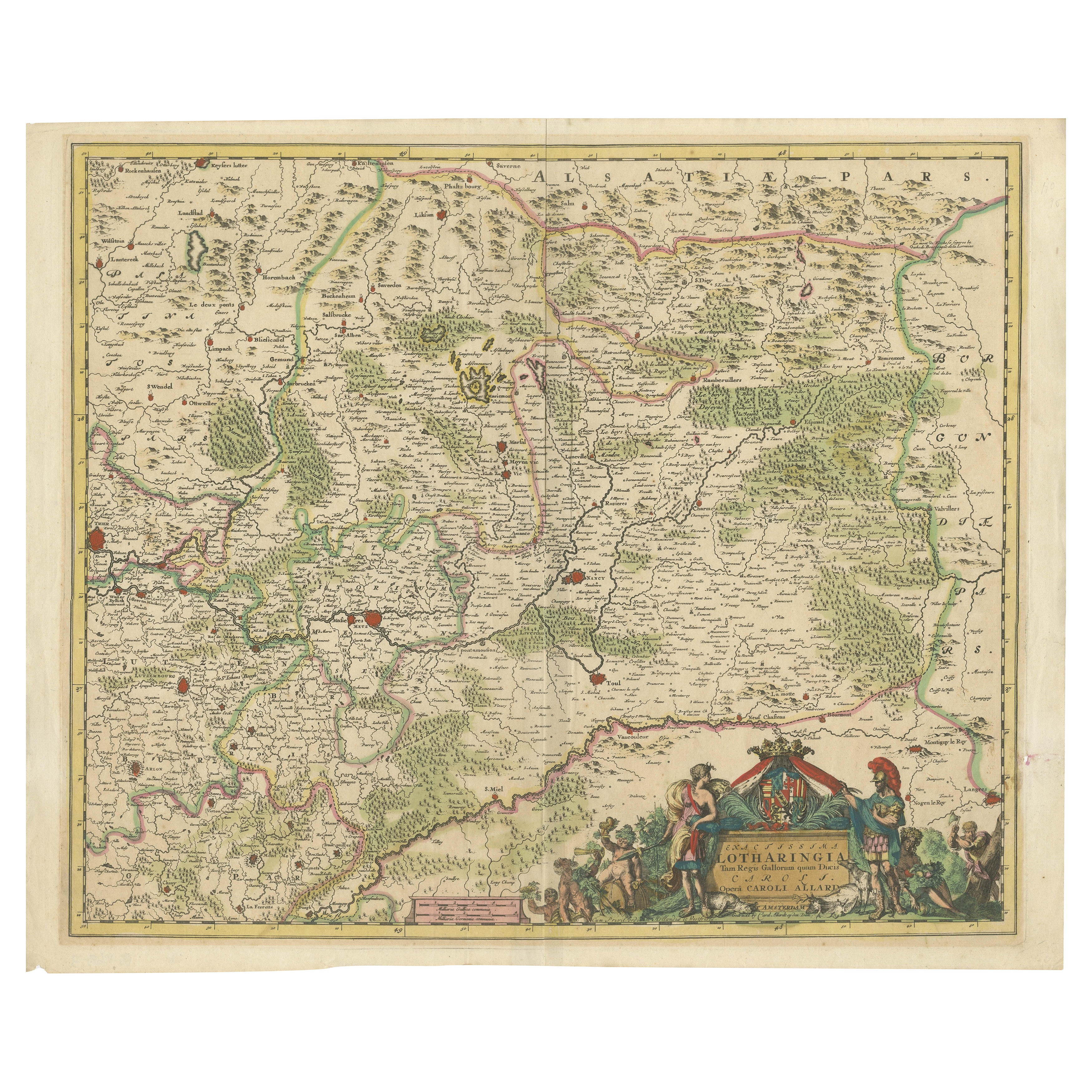
Historic 1690 Map of Lorraine in France by Allard - Cities of Toul, Nancy, Metz
Located in Langweer, NL
Exactissima Lotharingia - A Rare 17th Century Map of Lorraine by Carel Allard
This fascinating map of Lorraine, created by Carel Allard around 1690, is a stunning example of coppe...
Category
Antique 1690s Maps
Materials
Paper
$660 Sale Price
20% Off
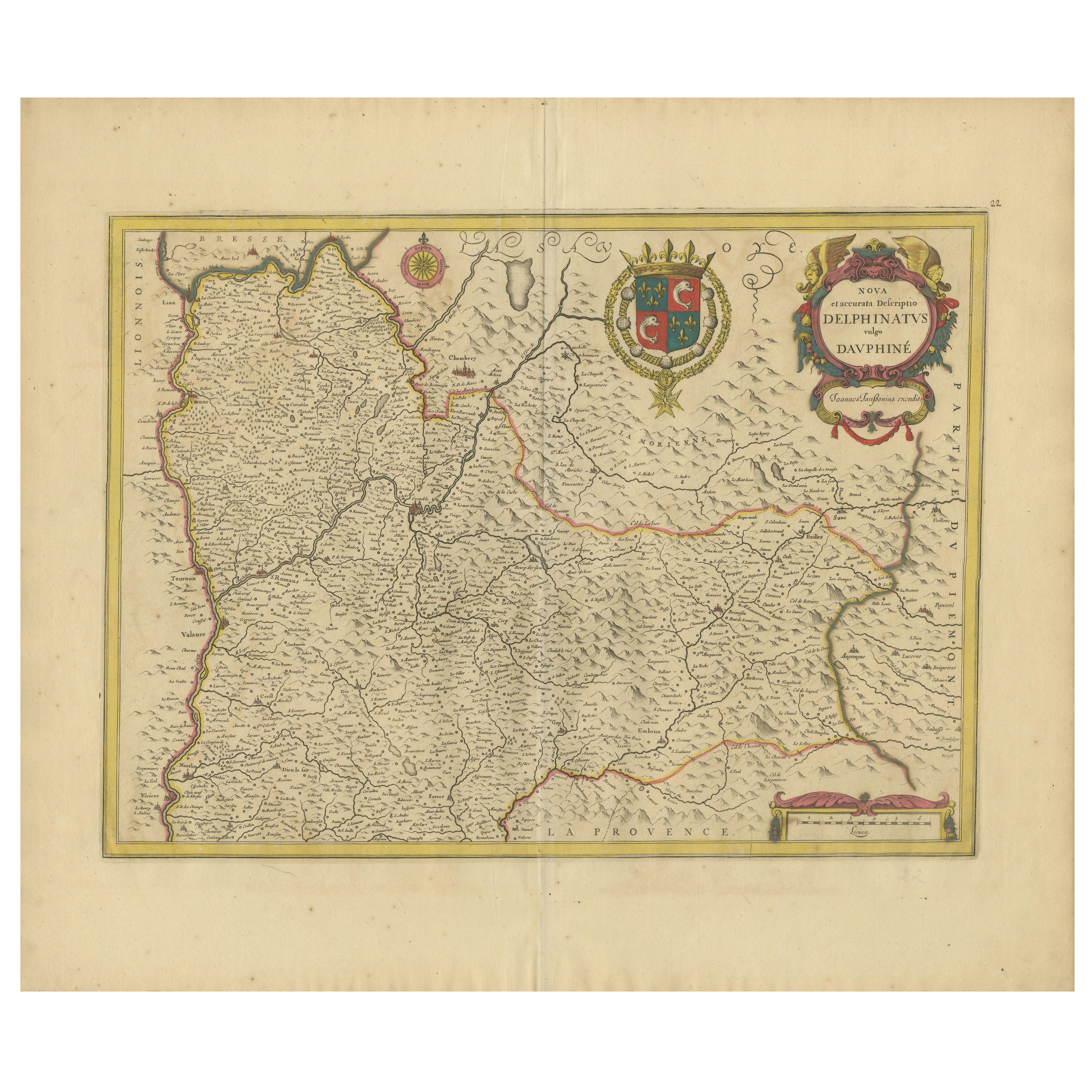
Rare 17th-Century Map of Dauphiné in Southeastern France by F. De Wit, ca.1688
Located in Langweer, NL
Title: Rare Hand-Colored 17th-Century Map of Dauphiné by Frederik De Wit c. 1688
Description: This captivating 17th-century map of Dauphiné, titled "Nova et Accurata Delphinatus Vul...
Category
Antique 1680s Maps
Materials
Paper

You May Also Like
1640 Joan Bleau Map Entitled"Diocecese de rheims et le pais de rethel, " Eic.a011
Located in Norton, MA
1640 Joan Bleau map entitled
"Diocecese de rheims et le pais de rethel,"
Ric.a011
OAN BLAEU
Diocecese de Rheims, et le pais de Rethel.
Handcolored engraving, c.1640.
...
Category
Antique 17th Century Dutch Maps
Materials
Paper

1590 Mercator Map Entitled "France Picardie Champaigne, Ric.0001
Located in Norton, MA
Description: Published in Amsterdam by Mercator/Hondius ca. 1590.
Ric.0001
Artists and Engravers: Map : 'France Picardie Champaigne cum regionibus adiacentibus'. (Map of the french provinces of Picardie and Champagne.) Copper engraved map of the french provinces of Picardie and Champagne, showing the cities of Caen, Paris, Melun, Auxerre, Verdun, etc. Copperplate engraving on verge type hand laid paper with watermark. Description: Published in Amsterdam by Mercator/Hondius ca. 1600.Artists and Engravers: Mercator was born in Rupelmonde in Flanders and studied in Louvain under Gemma Frisius, Dutch writer, astronomer and mathematician. The excellence of his work brought him the patronage of Charles V, but in spite of his favor with the Emperor he was caught up in the persecution of Lutheran protestants and charged with heresy, fortunately without serious consequences. No doubt the fear of further persecution influenced his move in 1552 to Duisburg, where he continued the production of maps, globes and instruments. Mercator's sons and grandsons, were all cartographers and made their contributions in various ways to his atlas. Rumold, in particular, was responsible for the complete edition in 1595. The map plates...
Category
Antique 16th Century Dutch Maps
Materials
Paper

1656 Jansson Map Metz Region of France Entitled "Territorium Metense" Ric0014
Located in Norton, MA
1656 Jansson map Metz Region of France entitled "Territorium Metense."
Ric0014
" Authentic" - Map of the historical region surrounding Metz, in Lorraine, France.
Oriented with ...
Category
Antique 17th Century Dutch Maps
Materials
Paper

1620 Map of Artois Entitled "Artesia Comitatvs Artois, " by Bleau, Ric.a012
Located in Norton, MA
1640 map of Artois entitled
"Artesia Comitatvs Artois,"
by Bleau
Colored
A-012.
Detailed map of the northern province of Artois, France on the border with Belgium. Feature...
Category
Antique 17th Century Dutch Maps
Materials
Paper

1657 Janssonius Map of Vermandois and Cappelle, Ric. A-004
Located in Norton, MA
1657 Janssonius map of
Vermandois and Cappelle
Ric.a004
Description: Antique map of France titled 'Descriptio Veromanduorum - Gouvernement de la Cappelle'. Two detailed maps o...
Category
Antique 17th Century Unknown Maps
Materials
Paper

1771 Bonne Map of Poitou, Touraine and Anjou, France, Ric.a015
Located in Norton, MA
1771 Bonne Map of Poitou,
Touraine and Anjou, France
Ric.a015
1771 Bonne map of Potiou, Touraine and Anjou entitled "Carte des Gouvernements D'Anjou et du Saumurois, de la Touraine, du Poitou,du Pays d'aunis, Saintonge?Angoumois,"
Carte des gouvernements d'Anjou et du Saumurois, de la Touraine, du Poitou, du Pays d'Aunis, Saintonge-Angoumois. Projettee et assujettie au ciel par M. Bonne, Hyd. du Roi. A Paris, Chez Lattre, rue St. Jacques a la Ville de Bord(ea)ux. Avec priv. du Roi. 1771. Arrivet inv. & sculp., Atlas moderne ou collection de cartes sur toutes...
Category
Antique 17th Century Unknown Maps
Materials
Paper

More Ways To Browse
Alsace French
Map Of Native American Tribes
Old Spice
Romania Map
Used Furniture Nova Scotia
18th Century Scottish Collectibles
Antique Furniture Northumberland
Antique Map Nova Scotia
Antique Map Palestine
California Island Map
Constantinople Map
Croatian Antiques
Jamaican Antique
Large Map Of Italy
Louisiana Antiques
Maps South East Asia
New Jersey Antique Furniture
Ptolemy Map