Items Similar to Old Map of Asia Depicting Asia in the 6th through the 9th Centuries, ca. 1855


Want more images or videos?
Request additional images or videos from the seller
1 of 5
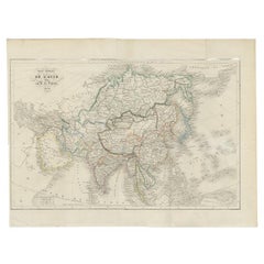
Old Map of Asia Depicting Asia in the 6th through the 9th Centuries, ca. 1855
$239.37
$299.2220% Off
£176.57
£220.7220% Off
€200
€25020% Off
CA$331.66
CA$414.5820% Off
A$360.12
A$450.1520% Off
CHF 190.71
CHF 238.3920% Off
MX$4,414.07
MX$5,517.5920% Off
NOK 2,360.13
NOK 2,950.1620% Off
SEK 2,230.20
SEK 2,787.7520% Off
DKK 1,522.57
DKK 1,903.2220% Off
About the Item
Antique map Asia titled 'Asien vom VIten bis in die erste Haelfte des IXten Jahrhundert’s Zeit der grossfen Ausdehnung des Ralifen Reiches; des Reiches Tufan oder Tubet und der Chang Dynastie in China'. Old map of Asia depicting Asia in the 6th through the 9th centuries. This period roughly corresponds to the Chang Dynasty in China and the Tufan kings of Tibet. Originates from Karl von Spruner's 'Historical Atlas'.
Artists and Engravers: Karl Spruner von Merz (15 November 1803 – 24 August 1892), or Karl von Spruner as he preferred to be known, was a German cartographer and scholar. He is best known for his historical atlases. The first of these was his Historischer Atlas von Bayern (historical atlas of Bavaria), published in 1838. His greatest work was his Historisch-Geographischer Hand-Atlas, whose first edition appeared in parts from 1848 to 1853.
We sell original antique maps to collectors, historians, educators and interior decorators all over the world. Our collection includes a wide range of authentic antique maps from the 16th to the 20th centuries. Buying and collecting antique maps is a tradition that goes back hundreds of years. Antique maps have proved a richly rewarding investment over the past decade, thanks to a growing appreciation of their unique historical appeal. Today the decorative qualities of antique maps are widely recognized by interior designers who appreciate their beauty and design flexibility. Depending on the individual map, presentation, and context, a rare or antique map can be modern, traditional, abstract, figurative, serious or whimsical. We offer a wide range of authentic antique maps for any budget.
- Dimensions:Height: 14.57 in (37 cm)Width: 18.12 in (46 cm)Depth: 0 in (0.01 mm)
- Materials and Techniques:
- Period:
- Date of Manufacture:1855
- Condition:Condition: Good, some staining. Please study image carefully.
- Seller Location:Langweer, NL
- Reference Number:Seller: BG-071401stDibs: LU3054326090872
About the Seller
5.0
Recognized Seller
These prestigious sellers are industry leaders and represent the highest echelon for item quality and design.
Platinum Seller
Premium sellers with a 4.7+ rating and 24-hour response times
Established in 2009
1stDibs seller since 2017
2,623 sales on 1stDibs
Typical response time: <1 hour
- ShippingRetrieving quote...Shipping from: Langweer, Netherlands
- Return Policy
Authenticity Guarantee
In the unlikely event there’s an issue with an item’s authenticity, contact us within 1 year for a full refund. DetailsMoney-Back Guarantee
If your item is not as described, is damaged in transit, or does not arrive, contact us within 7 days for a full refund. Details24-Hour Cancellation
You have a 24-hour grace period in which to reconsider your purchase, with no questions asked.Vetted Professional Sellers
Our world-class sellers must adhere to strict standards for service and quality, maintaining the integrity of our listings.Price-Match Guarantee
If you find that a seller listed the same item for a lower price elsewhere, we’ll match it.Trusted Global Delivery
Our best-in-class carrier network provides specialized shipping options worldwide, including custom delivery.More From This Seller
View AllAntique Map of Asia from a German School Atlas, c.1870
Located in Langweer, NL
Antique map titled 'Asien'. Old map of the Asian continent. This map originates from 'H. Kiepert's Kleiner Atlas der Neueren Geographie für Schule und Haus'.
Artists and Engravers:...
Category
Antique 19th Century Maps
Materials
Paper

$136 Sale Price
20% Off
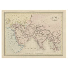
Antique Map of Asia by Lapie, 1842
Located in Langweer, NL
Antique map titled 'Carte de l'Asie'. Map of Asia. This map originates from 'Atlas universel de géographie ancienne et moderne (..)' by Pierre M. Lapie and...
Category
Antique Mid-19th Century Maps
Materials
Paper

$574 Sale Price
20% Off
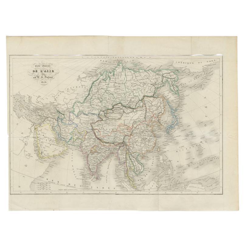
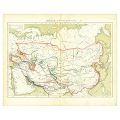
Antique Map of The Asian Continent, 1855
Located in Langweer, NL
Antique map titled 'Carte Générale de l 'Asie'. Beautiful map of the Asian continent. This map originates from 'Voyage en Asie et en Afrique, d'aprés les récits des derniers voyageur...
Category
Antique 19th Century Maps
Materials
Paper
$239 Sale Price
20% Off
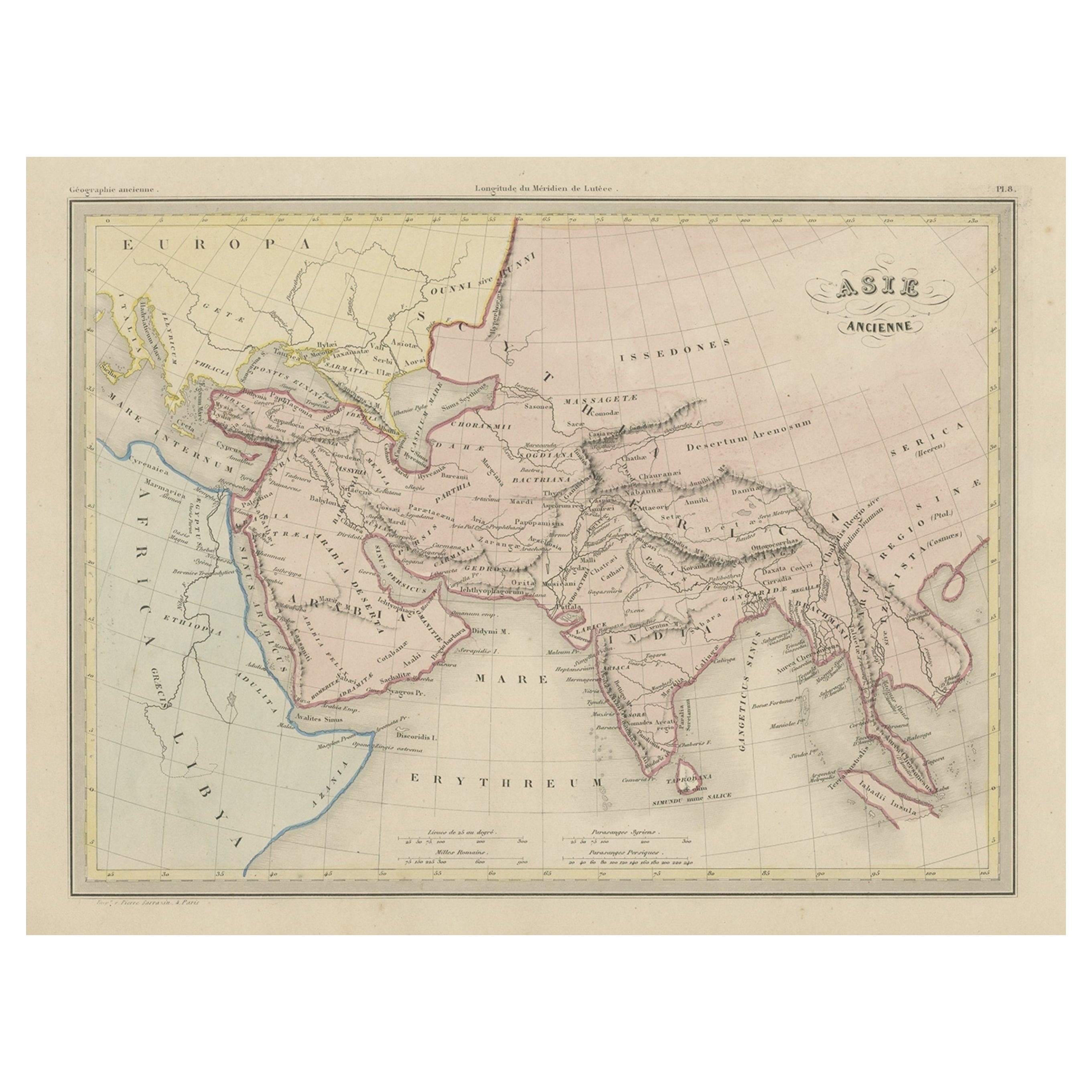
Original Antique Map of Ancient Asia, 1847
Located in Langweer, NL
Description: Antique map Asia titled 'Asie Ancienne'.
This is an original antique map of Ancient Asia and originates from 'Atlas de la Geographie ...
Category
Antique 1840s Maps
Materials
Paper
$172 Sale Price
20% Off
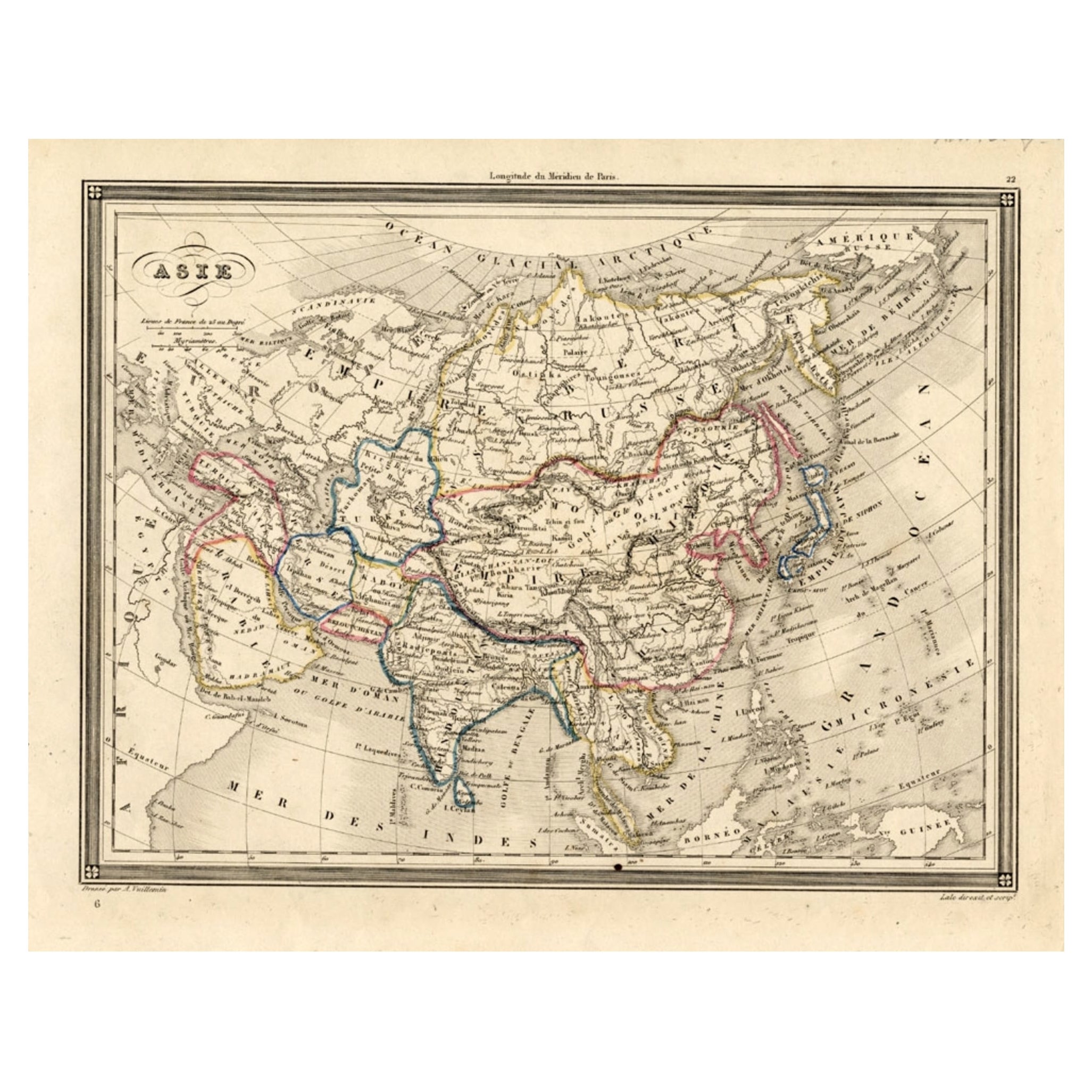
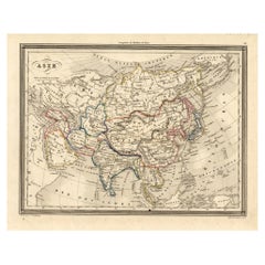
Antique Map of Asia, 1846
Located in Langweer, NL
Antique map titled 'Asie'. Original antique map of Asia. Source unknown, to be determined.
Artists and Engravers: Alexandre Vuillemin (1812-188...
Category
Antique 19th Century Maps
Materials
Paper
$74 Sale Price
20% Off
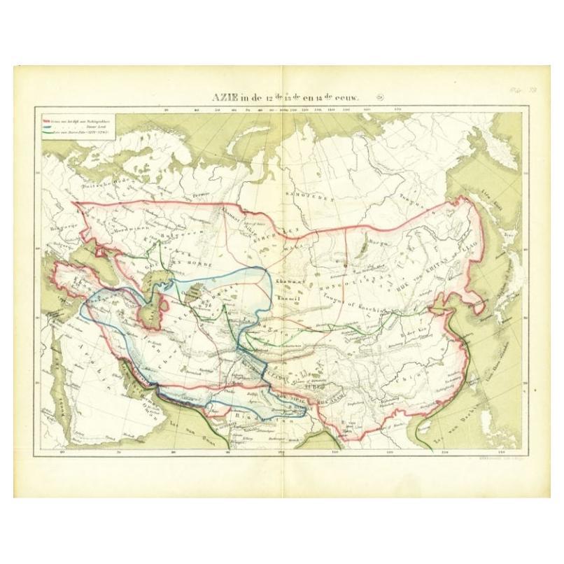
Antique Map of Asia in the 12th, 13th and 14th Century, 1877
Located in Langweer, NL
Antique map titled 'Azie in de 12de, 13de en 14de eeuw.' (Asia in the 12th, 13th and 14th century). Historic map of Asia. This original antique map origi...
Category
Antique 19th Century Maps
Materials
Paper
$71 Sale Price
20% Off
You May Also Like
Antique 1803 Italian Map of Asia Including China Indoneseia India
Located in Amsterdam, Noord Holland
Antique 1803 Italian Map of Asia Including China Indoneseia India
Very nice map of Asia. 1803.
Additional information:
Type: Map
Country of Manufacturing: Europe
Period: 19th centu...
Category
Antique 19th Century European Maps
Materials
Paper

$584 Sale Price
20% Off
Large Original Antique Map of Asia by Sidney Hall, 1847
Located in St Annes, Lancashire
Great map of Asia
Drawn and engraved by Sidney Hall
Steel engraving
Original colour outline
Published by A & C Black. 1847
Unframed
Free shipping
Category
Antique 1840s Scottish Maps
Materials
Paper

Original Antique Map of China, Arrowsmith, 1820
Located in St Annes, Lancashire
Great map of China
Drawn under the direction of Arrowsmith
Copper-plate engraving
Published by Longman, Hurst, Rees, Orme and Brown, 1820
Unfr...
Category
Antique 1820s English Maps
Materials
Paper

Antique French Map of Asia Including China Indoneseia India, 1783
Located in Amsterdam, Noord Holland
Very nice map of Asia. 1783 Dedie au Roy.
Additional information:
Country of Manufacturing: Europe
Period: 18th century Qing (1661 - 1912)
Condition: Overall Condition B (Good Used)...
Category
Antique 18th Century European Maps
Materials
Paper

$648 Sale Price
20% Off
Super Rare Antique French Map of Chine and the Chinese Empire, 1780
Located in Amsterdam, Noord Holland
Super Rare Antique French Map of Chine and the Chinese Empire, 1780
Very nice map of Asia. 1780 Made by Bonne.
Additional information:
Type: Map
...
Category
Antique 18th Century European Maps
Materials
Paper

$584 Sale Price
33% Off
Original Antique Map of The Eastern Hemisphere by Dower, circa 1835
Located in St Annes, Lancashire
Nice map of the Eastern Hemisphere
Drawn and engraved by J.Dower
Published by Orr & Smith. C.1835
Unframed.
Free shipping
Category
Antique 1830s English Maps
Materials
Paper

More Ways To Browse
Biblical Maps
Maps Of Mediterranean
Treasure Map
Antique Navigational Tools
Mississippi Furniture
Caribbean Antiques
Antique Maps West Indies
Antique Mozambique
Malaysian Antique Furniture
Relief Map
Sur Tout
Antique Civil War Maps
Antique Nautical Maps
Civil War Map
Royal Stuart
Sri Lanka Map
Braun Artist
Hand Painted Antique Map