Items Similar to Old Map of Southern Russia, Incl the Extent of the Kingdom of Poland, 1882


Want more images or videos?
Request additional images or videos from the seller
1 of 5
Old Map of Southern Russia, Incl the Extent of the Kingdom of Poland, 1882
$325.21
$406.5120% Off
£240.75
£300.9420% Off
€272
€34020% Off
CA$450.01
CA$562.5120% Off
A$496.12
A$620.1520% Off
CHF 259.55
CHF 324.4420% Off
MX$6,086.48
MX$7,608.1120% Off
NOK 3,267.28
NOK 4,084.1020% Off
SEK 3,055.42
SEK 3,819.2820% Off
DKK 2,071.93
DKK 2,589.9120% Off
About the Item
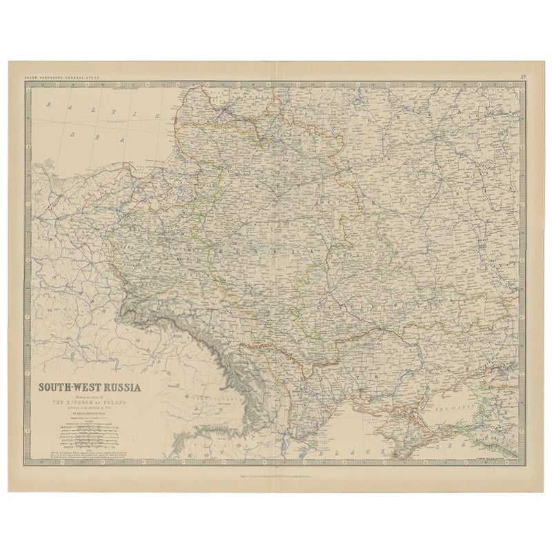
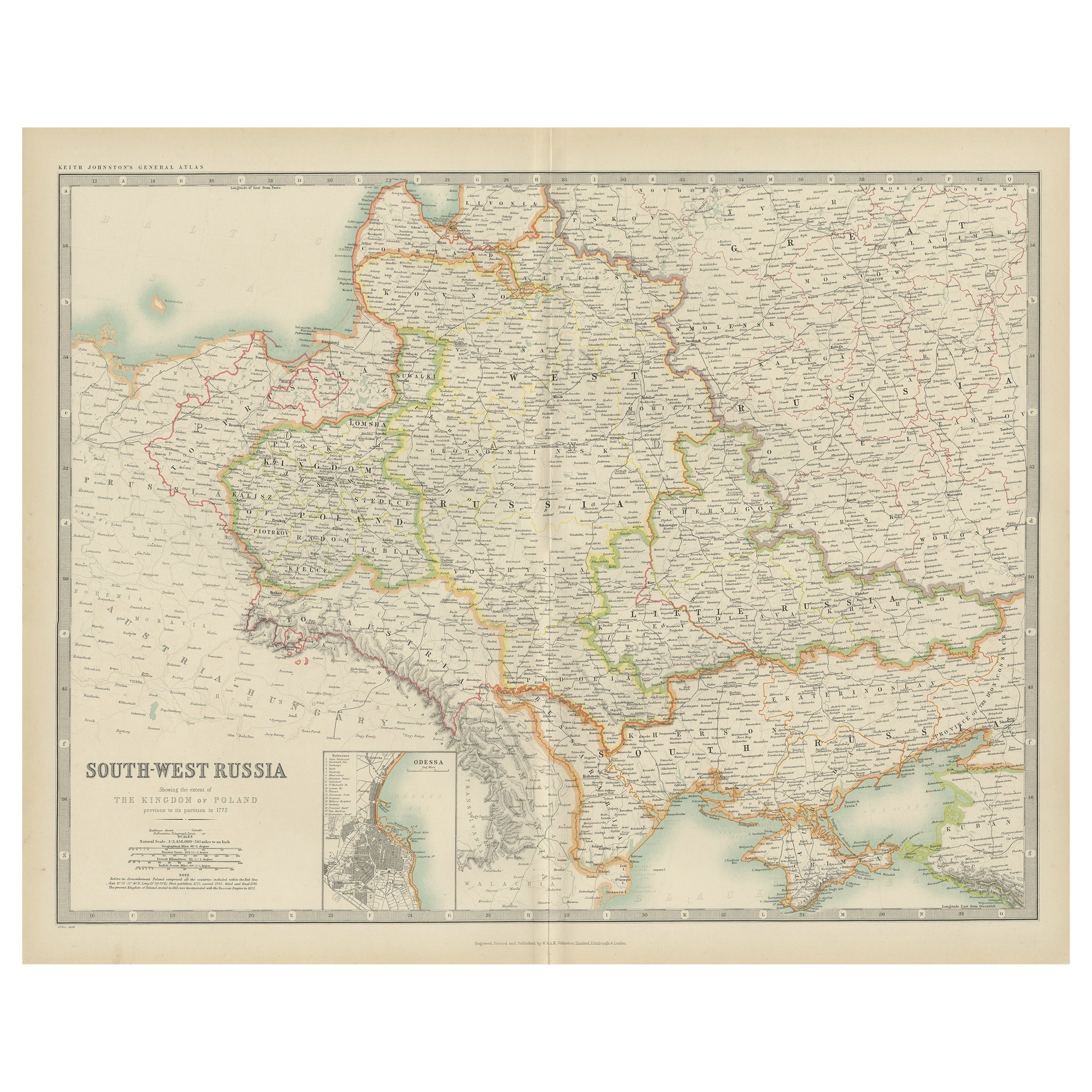
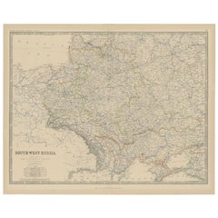
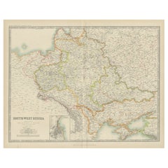
Antique map titled 'South-West Russia'.
Old map of southern Russia, also showing the extent of the Kingdom of Poland. This map originates from 'The Royal Atlas of Modern Geography, Exhibiting, in a Series of Entirely Original and Authentic Maps, the Present Condition of Geographical Discovery and Research in the Several Countries, Empires, and States of the World' by A.K. Johnston. Published by W. and A.K. Johnston, 1882.
Artists and Engravers: Alexander Keith Johnston LLD (1804-1871) was a Scottish geographer. He was a pupil of the Edinburgh engraver and mapmaker, James Kirkwood. In 1826, he joined his brother William (who would become Sir William Johnston, Lord Provost of Edinburgh) in a printing and engraving business, forming the well-known cartographical firm of W. and A. K. Johnston.
- Dimensions:Height: 19.53 in (49.6 cm)Width: 24.1 in (61.2 cm)Depth: 0 in (0.02 mm)
- Materials and Techniques:
- Period:
- Date of Manufacture:1882
- Condition:Wear consistent with age and use. Condition: Good, general age-related toning. Please study image carefully.
- Seller Location:Langweer, NL
- Reference Number:Seller: BG-11823-27 1stDibs: LU3054327233492
About the Seller
5.0
Recognized Seller
These prestigious sellers are industry leaders and represent the highest echelon for item quality and design.
Platinum Seller
Premium sellers with a 4.7+ rating and 24-hour response times
Established in 2009
1stDibs seller since 2017
2,613 sales on 1stDibs
Typical response time: <1 hour
- ShippingRetrieving quote...Shipping from: Langweer, Netherlands
- Return Policy
Authenticity Guarantee
In the unlikely event there’s an issue with an item’s authenticity, contact us within 1 year for a full refund. DetailsMoney-Back Guarantee
If your item is not as described, is damaged in transit, or does not arrive, contact us within 7 days for a full refund. Details24-Hour Cancellation
You have a 24-hour grace period in which to reconsider your purchase, with no questions asked.Vetted Professional Sellers
Our world-class sellers must adhere to strict standards for service and quality, maintaining the integrity of our listings.Price-Match Guarantee
If you find that a seller listed the same item for a lower price elsewhere, we’ll match it.Trusted Global Delivery
Our best-in-class carrier network provides specialized shipping options worldwide, including custom delivery.More From This Seller
View AllAntique Map of Southern Russia by Johnston, 1882
Located in Langweer, NL
"Antique map titled 'South-West Russia'. Old map of southern Russia, also showing the extent of the Kingdom of Poland. This map originates from 'The Royal Atlas of Modern Geography, ...
Category
Antique 19th Century Maps
Materials
Paper
$114 Sale Price
20% Off
Antique Map of South-West Russia by A.K. Johnston, 1865
Located in Langweer, NL
Antique map titled 'South-West Russia showing the extent of the Kingdom of Poland previous to its partition in 1772'. This map originates from the ‘Royal Atlas of Modern Geography’ b...
Category
Antique Mid-19th Century Maps
Materials
Paper

$239 Sale Price
20% Off
Antique Map of South-West Russia by Johnston (1909)
Located in Langweer, NL
Antique map titled 'South-West Russia'. Original antique map of South-West Russia. With inset map of Odessa. This map originates from the ‘Royal Atlas of Modern Geography’. Published...
Category
Early 20th Century Maps
Materials
Paper
$239 Sale Price
20% Off
Antique Map of Russia and Surroundings by Stieler, 1874
Located in Langweer, NL
Antique map titled 'Nord- & Mittal-Asien, Ubersicht des Russischen Reiches.' A map of Russia in scale 1:20.000.000. The depicted area spans from Iran and Sweden in the left edge of t...
Category
Antique 19th Century Maps
Materials
Paper

$66 Sale Price
20% Off
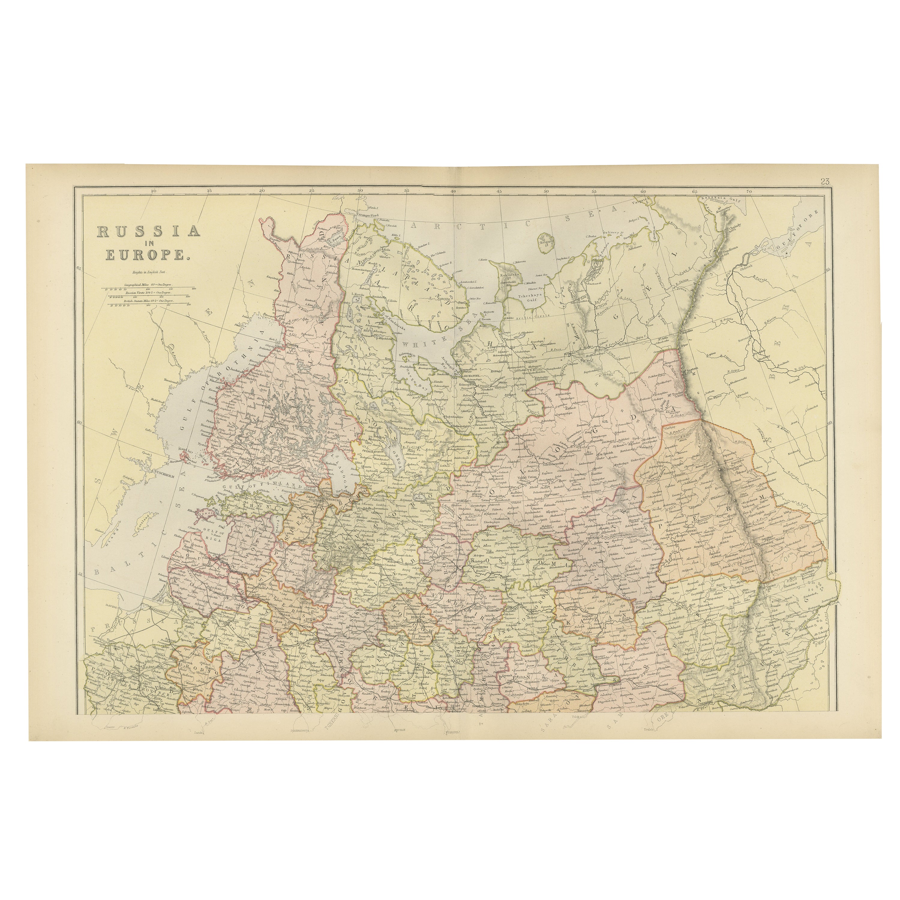
Original Antique Map of Russia in Europe, 1882
Located in Langweer, NL
Embark on an enthralling journey with an original Antique Map of European Russia from the esteemed 'Comprehensive Atlas and Geography of the World,' meticulously crafted in 1882. Thi...
Category
Antique 1880s Maps
Materials
Paper
$181 Sale Price
20% Off
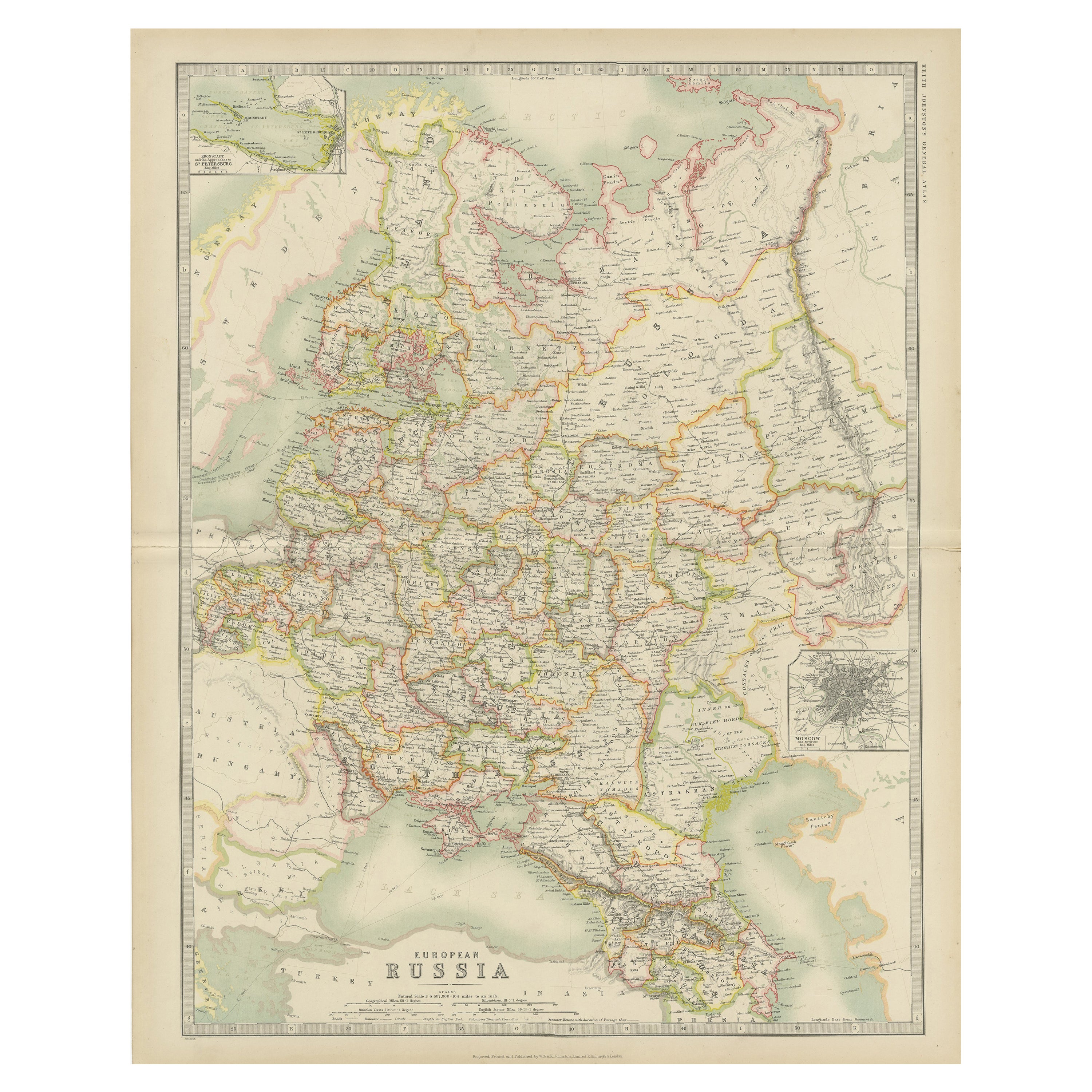
Antique Map of Russia in Europe by Johnston (1909)
Located in Langweer, NL
Antique map titled 'European Russia'. Original antique map of Russia in Europe. With inset maps of St Petersburg and Moscow. This map originates from the ‘Royal Atlas of Modern Geogr...
Category
Early 20th Century Maps
Materials
Paper
$239 Sale Price
20% Off
You May Also Like
Russia, Western and Southern Part. Century Atlas antique vintage map
Located in Melbourne, Victoria
'The Century Atlas. Russia, Western and Southern Part'
Original antique map, 1903.
Inset map tilted 'St Petersburg and Environs'.
Central fold as issued. Map name and number printe...
Category
Early 20th Century Victorian More Prints
Materials
Lithograph

Russia in Europe with Poland and Finland. Century Atlas antique vintage map
Located in Melbourne, Victoria
'The Century Atlas. Russia in Europe with Poland and Finland'
Original antique map, 1903.
Central fold as issued. Map name and number printed on the reverse corners.
Sheet 40cm by ...
Category
Early 20th Century Victorian More Prints
Materials
Lithograph

1853 Map of "Russia in Europe Including Poland" Ric.r016
Located in Norton, MA
Description
Russia in Europe incl. Poland by J Wyld c.1853
Hand coloured steel engraving
Dimension: Paper: 25 cm W x 33 cm H ; Sight: 22 cm W x 28 cm H
Condition: Good ...
Category
Antique 19th Century Unknown Maps
Materials
Paper

Large Original Antique Map of Poland by Sidney Hall, 1847
Located in St Annes, Lancashire
Great map of Poland
Drawn and engraved by Sidney Hall
Steel engraving
Original colour outline
Published by A & C Black. 1847
Unframed
...
Category
Antique 1840s Scottish Maps
Materials
Paper

1849 Map of "Europaische Russland", 'Meyer Map of European Russia', Ric. R017
Located in Norton, MA
1849 Map of
"Europaische Russland"
( Meyer Map of European Russia)
Ric.r017
A lovely map of European Russia dating to 1849 by Joseph Meyer. It covers the European portions of...
Category
Antique 19th Century Unknown Maps
Materials
Paper

1832 Large Map "Russian & Poland" Ric. R0012
Located in Norton, MA
Large map 1832
"Russian & Poland"
Ric.r0012
Russia & Poland, by J. Arrowsmith. London, pubd. 15 Feby. 1832 by J. Arrowsmith, 35 Essex Street, Strand., ...
Category
Antique 19th Century Unknown Maps
Materials
Paper

More Ways To Browse
Used Durham Furniture
Antique Maps Of Israel
Antique Maps Of Russian Empire
Cyprus Antique Maps
Kolkata Antique Furniture
Afghanistan Antique Map
Antique Furniture Delaware
Antique Furniture Wisconsin
Antique Map By Coronelli
Antique Map Iceland
Magellan Map
Map Ukraine
Used Office Furniture Michigan
Antique Manitoba
Australian Colonial
Bengal Map
Mariners Chart
Northern Pacific Railroad