1 of 7
Sweden & Adjacent Portions of Scandinavia: A Hand-Colored 18th C. Map by Homann
$975List Price
About the Item
- Creator:Johann Baptist Homann (Artist)
- Dimensions:Height: 21 in (53.34 cm)Width: 23.38 in (59.39 cm)Depth: 0.07 in (1.78 mm)
- Materials and Techniques:Paper,Engraved
- Place of Origin:
- Period:1720-1729
- Date of Manufacture:1728
- Condition:Wear consistent with age and use.
- Seller Location:Alamo, CA
- Reference Number:Seller: # 41931stDibs: LU5206223889392

Johann Baptist Homann
Johann Baptist Homann (1663-1724) was a mapmaker who founded a respected and prolific publishing company, which continued long after his death as Homann Heirs. Homann lived his entire life in Bavaria, particularly in Nuremberg. Initially, Johann trained to become a priest before converting to Protestantism and working as a notary. In 1702, Johann founded a publishing house that specialized in engravings. The firm flourished, becoming the leading map publisher in Germany and an important entity in the European map market. In 1715, Johann was named Imperial Geographer to the Holy Roman Empire by Charles VI and made a member of the Prussian Academy of Sciences. Most importantly for his business, his reputation and contacts gained him imperial printing privileges which protected his publications and recommended him to customers.
Authenticity Guarantee
In the unlikely event there’s an issue with an item’s authenticity, contact us within 1 year for a full refund. DetailsMoney-Back Guarantee
If your item is not as described, is damaged in transit, or does not arrive, contact us within 7 days for a full refund. Details24-Hour Cancellation
You have a 24-hour grace period in which to reconsider your purchase, with no questions asked.Vetted Professional Sellers
Our world-class sellers must adhere to strict standards for service and quality, maintaining the integrity of our listings.Price-Match Guarantee
If you find that a seller listed the same item for a lower price elsewhere, we’ll match it.Trusted Global Delivery
Our best-in-class carrier network provides specialized shipping options worldwide, including custom delivery.You May Also Like
Antique Map of the Netherlands and Belgium by Homann, circa 1710
By Johann Baptist Homann
Located in Langweer, NL
Antique map titled 'Tabula Generalis Totius Belgii Provinciae XVII. Infer. Germaniae (..)'. Map of the Benelux countries by Johann Baptist Homann. Shows the area between the Seine es...
Category
Antique Early 18th Century German Maps
Materials
Paper

$764 Sale Price
20% Off
Free Shipping
H 20.87 in W 24.02 in D 0.02 in
Stunning Antique Map of Northern Italy by J.B. Homann, circa 1745
By Johann Baptist Homann
Located in Langweer, NL
This beautiful hand-colored map covers from Bergamo east as far as Albona (Labin) and from Vipiteno Sterzing south as far as Florence.
The map is exceptionally detailed, noting towns, rivers, lakes, cities and a host of additional topographical features. Includes neighboring Parma, Modena, Mantua and Mirandol. The map depicts the Veneto region and its vicinity during the decline of the Republic of Venice. A key in included in the top left quadrant of the map, while a beautifully engraved title cartouche adorns the lower right quadrant. This map was issued in Homann Heirs circa 1745 edition of Atlas Novus Terrarum Orbis.
Category
Antique Mid-18th Century Maps
Materials
Paper

$621 Sale Price
25% Off
H 20.08 in W 23.82 in D 0.02 in
Antique Map of Scandinavia: Norway, Sweden and Denmark
Located in Langweer, NL
Antique map titled 'Suède, Norwège & Danemark'. Attractive map of Scandinavia, with Sweden, Norway and Denmark. With an inset map of Iceland and th...
Category
Antique Mid-19th Century Maps
Materials
Paper
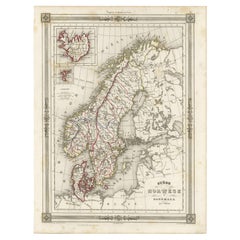
$114 Sale Price
20% Off
H 13.31 in W 10.12 in D 0.02 in
Antique Map of Africa by Homann Heirs, '1804'
Located in Langweer, NL
Antique map titled 'Charte von Africa'. Large, original antique map of Africa by Franz Ludwig Güssefeld. Published by Homann Heirs, 1804.
Category
Antique Early 19th Century Maps
Materials
Paper

$1,431 Sale Price
20% Off
H 21.86 in W 25.99 in D 0.02 in
Antique Map of Oberlausitz by Homann Erben, '1746'
Located in Langweer, NL
Antique map titled 'Geographische Verzeichnung des Budissinischen Creises (..) - Carte du Cercle de Budissin (..)'. Copper engraved map of Oberlausitz, a historical region of Saxony ...
Category
Antique Mid-18th Century Maps
Materials
Paper
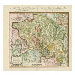
$429 Sale Price
20% Off
H 20.48 in W 21.66 in D 0.02 in
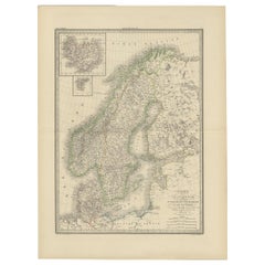
Antique Map of Scandinavia by Lapie, 1842
Located in Langweer, NL
Antique map titled 'Carte de la Scandinavie comprenant les Royaumes de Suède de Norwege et de Danemark'. Map of Scandinavia including Sweden, Norway and Denma...
Category
Antique Mid-19th Century Maps
Materials
Paper
Map of Scandinavia – Antique Atlas Map by A. Levasseur, France, 1875
Located in Langweer, NL
Map of Scandinavia – Antique Atlas Map by A. Levasseur, France, 1875
This elegant 19th-century map titled Carte des Royaumes de Suède, de Norvège et de Danem...
Category
Antique Late 19th Century French Maps
Materials
Paper

$388 Sale Price
35% Off
H 24.02 in W 18.71 in D 0.02 in
Antique Map of Menorca / Minorca by Homann Heirs '1757'
Located in Langweer, NL
Antique map titled 'Carte Topographique de l'Isle Minorque'. Scarce decorative map of Menorca (or Minorca), with two gorgeous views of Mahon and Fort St. Phillipe at the bottom. Publ...
Category
Antique Mid-18th Century Maps
Materials
Paper

$763 Sale Price
20% Off
H 21.46 in W 24.41 in D 0.02 in
Sweden & Norway – Antique Map of Scandinavia with Stockholm Inset, 1865
Located in Langweer, NL
Sweden & Norway – Antique Map of Scandinavia with Stockholm Inset, 1865
This finely detailed antique map titled Sweden & Norway (Scandinavia) offers a comprehensive 19th-century vie...
Category
Antique Mid-19th Century English Maps
Materials
Paper

$262 Sale Price
20% Off
H 24.41 in W 19.1 in D 0.02 in
Antique Map of Scandinavia by T. Jefferys, circa 1750
Located in Langweer, NL
Antique map titled 'Sweden, Denmark, Norway & Finland'. An original mid-18th century copper engraved antique map of Scandinavia by Thomas Jefferys....
Category
Antique Mid-18th Century Maps
Materials
Paper
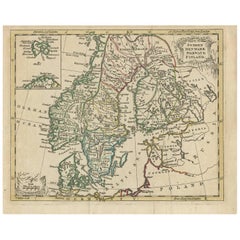
$181 Sale Price
20% Off
H 8.19 in W 10.08 in D 0.02 in
Recently Viewed
View AllMore Ways To Browse
Scroll Map
Antique Mediterranean Map
Antique Map Mexico
Antique Map Paris
Antique Puerto Rico
West Indies Antique Furniture
Map Of Ireland
Antique Indian Maps
Antique Map Ortelius
Antique Roman Map
D Plan
Roman Map
Map Of Paris
Large Vintage Map
Antique Map Of Ireland
Antique Maps Persia
Map Of Holy Land
Migeon Migeon