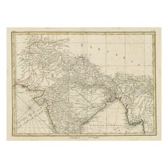
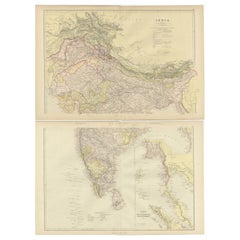
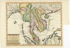
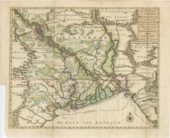
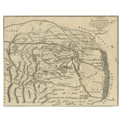
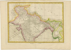
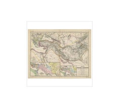
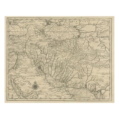
Old Map of North India From Kandahar East to Burma 'Pegu' and South to Goa, 1776
Located in Langweer, NL
Description: Antique map titled 'Indes Iere Feuille'. Old map of northern India.
Category
1770s Antique Map India
Materials
Paper
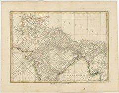
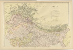
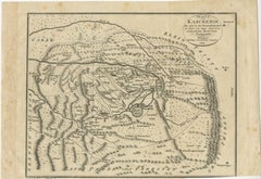
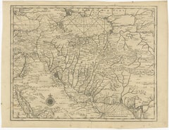
Old Map of North India From Kandahar East to Burma 'Pegu' and South to Goa, 1776
Located in Langweer, NL
Description: Antique map titled 'Indes Iere Feuille'. Old map of northern India.
Paper
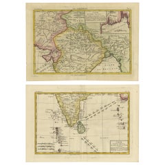
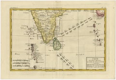
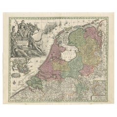
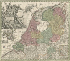
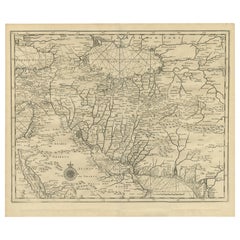
18th Century Cartographic Depiction of Upper India and Ceylon, 1835
Located in Langweer, NL
This atlas, apparently published in 1835, would include maps such as this on, showcasing detailed renderings of India and Ceylon (now known as Sri Lanka).
Paper
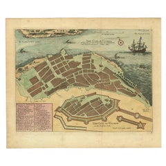
Very Attractive Handcolored Antique Plan of Cochin in India, 1744
By Philip Baldaeus
Located in Langweer, NL
Antique map titled 'The City of Cochin (..).' Plan of Cochin, Malabar Coast, India, during the attack by Admiral van Goens in 1663.
Paper

$205Sale Price|20% Off
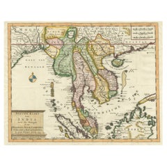
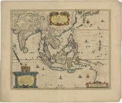
Antique Map of Southeast Asia by Dussy, 1778
Located in Langweer, NL
"Antique map titled 'Indostan presqu'isles de l'Inde, Chine, Tartarie Independante.' - A map of Asia: Hindustan, India and China.
Paper

$516Sale Price|25% Off
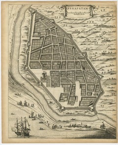
Attractive Hand-Colored Antique Plan of Nagapattinam in India, 1744
Located in Langweer, NL
Antique map titled 'Negapatam.' Attractive bird's-eye view of Nagapattinam, India from Churchill's 'A Collection of Voyages and Travels, some now first printed from original manuscri...
Paper

$70Sale Price|20% Off
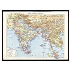
Antique Map of Southeast Asia by Larousse, 1897
Located in Langweer, NL
"Front: 'Carte Generale des Indes.' (General map of India / The Indies / Thailand / Malaysia).
Paper
$373Sale Price / set|20% Off
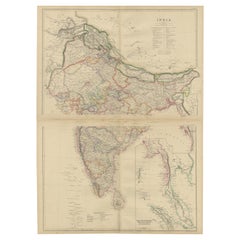
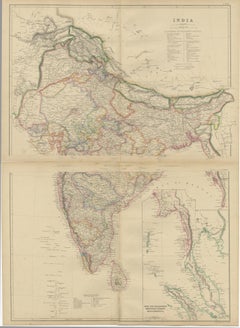
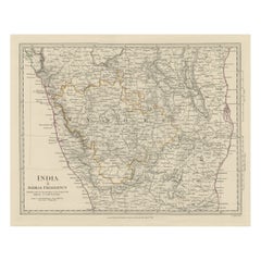
Vintage Cartographic Collection Set of India Explored - W. G. Blackie's 1859
Located in Langweer, NL
Antique map titled 'India'. Original antique map of India with inset maps of Pegu, the Tenasserim Provinces, straits settlements.
Paper


Antique Map of the Ancient Persian Empire – Imperium Persicum, 1817
Located in Langweer, NL
Keyword block: Imperium Persicum Antiquum, Persian Empire map, Achaemenid Empire map, Cyrus the Great empire map, ancient Persia map, Atlas Classica map, Robert Wilkinson map, London...
Paper


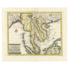
Original Antique Map of Southern Asia, Published in 1833
Located in Langweer, NL
Antique map titled 'Carte de l'Inde'. Detailed map extending from India in the west to Vietnam and the Malay Peninsula in the east.
Paper
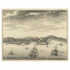
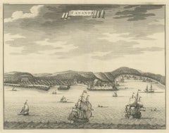
Original Antique Engraving of Kannur 'or Cannanore', Kerala, India, 1726
Located in Langweer, NL
Antique print, titled: 'Cananor' - This is a print of a view of Kannur (or Cannanore), Kerala, India. From the monumental: "Oud en Nieuw Oost-Indiën ..." by François Valentyn / Valen...
Paper
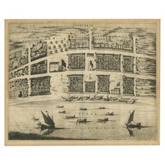

Antique Bird's-Eye Plan of Tutecoryn (Tuticorin or Thoothukudi), India, 1672
Located in Langweer, NL
Antique map, titled: 'Tutecoryn.' Bird's-eye plan of map of Tutecoryn (Tuticorin or Thoothukudi), India.
Paper

$68Sale Price|20% Off
Antique Map of Southeast Asia by Walker, c.1845
Located in Langweer, NL
"Untitled map of southeast Asia. This map depicts India, Indonesia, Australia and surrounding regions.
Paper
$140Sale Price|20% Off
Antique Map of the City of Kolkata by Balbi '1847'
Located in Langweer, NL
Antique map titled 'Calcutta'. Original antique map of the city of Kolkata, India.
Paper
Cartographic Elegance: The British Raj's India, 1882 Atlas by Blackie and Son
Located in Langweer, NL
The maps represent the geographical understanding of India during the British Raj, with an impressive degree of detail and accuracy for the time.
Paper
$597Sale Price|20% Off
Antique Map of Indochina, the Malaysian Peninsula and Northern Sumatra
Located in Langweer, NL
Antique map titled 'Nieuwe Kaart van India over de Ganges of van Malakka, Siam, Cambodia, Chiampa, Kochinchina, Laos, Pegu, Ava, enz'.
Paper
Dutch Republic & East Indies, Belgium Foederatum Map by Seutter, 18th Century
Located in Langweer, NL
This route map encompasses key regions including India, Indonesia, China, and Japan, visually reinforcing the importance of overseas trade and colonial networks in Dutch economic dom...
Paper
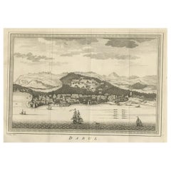
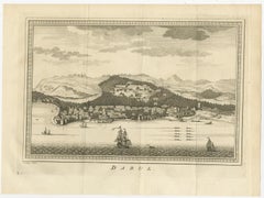
Old Copper Engraving of the Port City Dabhol in India, 1757
Located in Langweer, NL
Antique print titled 'Dabul'. Old print of the port city Dabhol in India. In the 15th and 16th centuries, Dabul was an opulent Muslim trade center. Around 1660 it was annexed to th...
Paper

$224Sale Price|20% Off
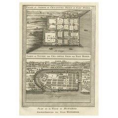
Palace & Gardens of Shah Shuja, Prince of Rajmahal & Munger, India, 1757
Located in Langweer, NL
Antique print titled 'Paleis en Tuynen van Cha-Sousa Prins van Ragi Mohol - Grondtekening der Stad Mongheer‘. This print depicts the palace and gardens of Shah Shuja, Prince of R...
Paper

Antique Map of Central America and the West Indies, 1882
Located in Langweer, NL
Antique map titled 'West India Islands and Central America'.
Paper
Late 16th Century Sheet with Copper Engravings of India, Pakistan, etc, 1598
Located in Langweer, NL
One sheet with two engraved maps, one on each site, and text in Italian. Late 16th century copper engravings in great condition, considering its age.
Paper

$112Sale Price|20% Off
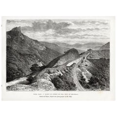
Bhor Ghat a Mountain Passage Between Karjat & Khandala, Maharashtra, India, 1883
Located in Langweer, NL
Plate: 'Bhor Ghat, 'Rampe du Chemin de fer, pres de Khandala'. This plate shows the Bhor Ghat a mountain passage located between Karjat and Khandala in Maharashtra, India. This plate...
Paper

$494Sale Price|20% Off
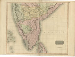
1816 Large Southern Hindostan Map by J. Thomson – New General Atlas
Located in Langweer, NL
This map is an excellent addition for collectors interested in historical maps of India, British colonial geography, or 19th-century cartographic works.
Paper

$494Sale Price|20% Off
1817 Large Northern Hindostan Map by J. Thomson – New General Atlas
Located in Langweer, NL
1817 Thomson Map of Northern Hindoostan – Detailed British Cartography of India This map, titled "A New Map of Hindoostan from the Latest Authorities," was drawn and engraved for Jo...
Paper
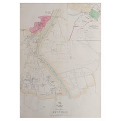

Large Original Antique City Plan of Lucknow, India. Edward Weller, 1861
Located in St Annes, Lancashire
Great city plan of Lucknow Lithograph engraving by Edward Weller Original colour Published, 1861 Unframed Good condition / slight corner loss bottom right shown in last image ...
Paper
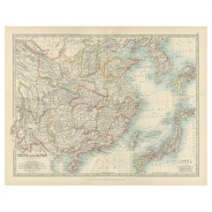
Antique Map of China, Taiwan, Korea, Hong-Kong and Japan, 1903
Located in Langweer, NL
Antique Map of China, Taiwan, Korea, Hong-Kong and Japan, 1903 Description: This antique map, titled "India (Southern Sheet) and the South Eastern Provinces," was engraved and publi...
Paper
$256Sale Price|20% Off
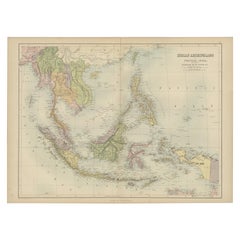
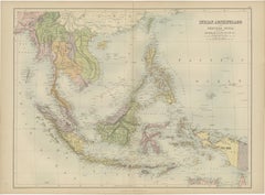
Antique Map of the East Indies by A & C. Black, 1870
Located in Langweer, NL
Antique map titled 'Indian Archipelago and Further India including Burmah, Siam, Anam &c'.
Paper
$1,680Sale Price|20% Off
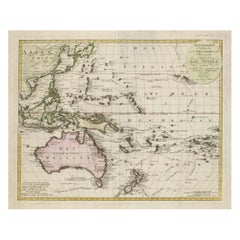
1802 Map of Australasia and the South Pacific - European Exploration Routes
Located in Langweer, NL
1802 Johann Walch Map of Australasia and the South Pacific - European Exploration Routes This 1802 map by Johann Walch provides a highly detailed view of Australasia and the South P...
Paper

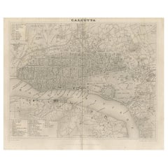
Antique Plan of the City of Calcutta 'India' by Letts, 1883
Located in Langweer, NL
Beautiful colored plan showing buildings (with key), Fort William, race ground, canals, railroads, etc. This plan originates from Letts's Popular Atlas.
Paper
$138Sale Price|66% Off
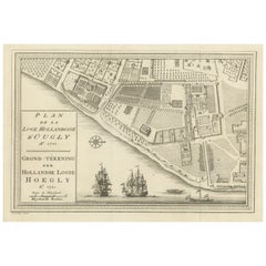
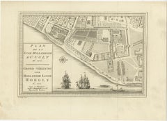
Original Antique Plan of the Dutch Settlement at Chinsura-Hooghly, India, 1746
Located in Langweer, NL
Antique print, titled: 'Plan de la Loge Hollandoise d'Ougly'. A plan of the Dutch settlement at Chinsura-Hooghly, India. This print originates from Prevost's 'Histoire Generale d...
Paper
$261Sale Price|20% Off
Antique Print of the Malabar Coast of India showing the VOC establishments, 1726
Located in Langweer, NL
Dutch print with the title: Platte Grond van t'Fort Tricoen male met de daar aangelegen Pagoods-Berg (Trincomalee, Sri Lanka) The map is taken from: 'Oud en Nieuw Oost-Indiën' van...
Paper
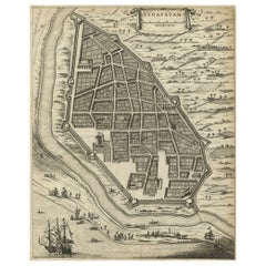
Antique Engraving of a Bird's-Eye Plan of Nagapattinam or Negapatam, India, 1672
Located in Langweer, NL
Antique map titled 'Negapatam.' Bird's-eye plan of Nagapattinam or Negapatam, India.
Paper
Asia in the Age of Exploration – Antique Map by Rigobert Bonne, c.1780
Located in Langweer, NL
KEYWORDS Asia map, Silk Road regions, China India trade routes, East Indies, Japan Philippines, spice trade geography CONDITION REPORT Uniform age toning.
Paper

$597Sale Price|20% Off
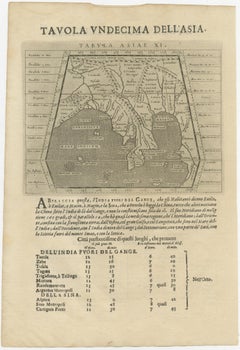
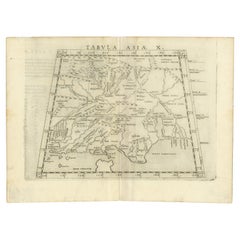
A Rare and Old Trapezoidal Projection of the Ganges and Himalaya Range in India
Located in Langweer, NL
Antique map titled 'Tabula Asiae X'. This Ptolemaic map on a trapezoidal projection is centered on India with recognizable river systems, but completely lacking the sub-continental s...
Paper
$457Sale Price|20% Off
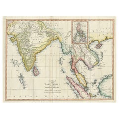
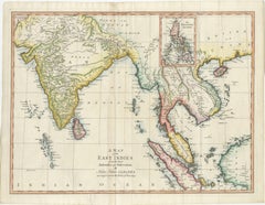
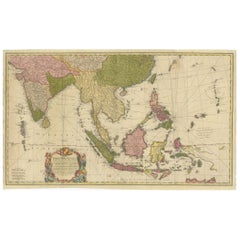
Antique Map of the East Indies by T. Kitchin, Engraved, Circa 1779
Located in Langweer, NL
Antique map titled 'A Map of the East Indies (..)'. Large antique map of Southeast Asia, India, and part of China, extending to Tibet, the Maladives, Sumatra, part of Borneo, Hainan,...
Paper
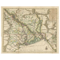
1726 Map of Bengal by Van der Aa after Valentijn – Dutch East Indies
Located in Langweer, NL
Keywords block for your listing: bengal map, van der aa, valentijn map, dutch east india company, voc map, 18th century india map, antique bengal map, orissa map, assam map, tripura ...
Paper


$2,319Sale Price|25% Off
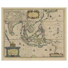
Old Antique Map of the East Indies and Southeast Asia, ca.1644
Located in Langweer, NL
Antique map titled 'India quae Orientalis dicitur, et Insulae adiacentes'.
Paper
$410Sale Price|20% Off
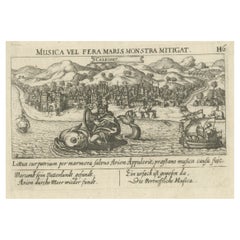
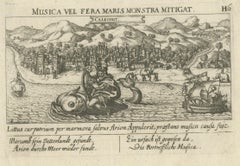
Striking Antique View of Kozhikode, also known as Calicut, in Kerala, India
Located in Langweer, NL
Antique print titled 'Calechut'. Wonderful, miniature copper engraving depicting Arion riding on a very cheerful looking sea monster in the important trading center of Calicut harbor...
Paper

$2,333Sale Price|20% Off
Original Antique Map of the East Indies (Indonesia) by Janssonius, c.1644
By Johannes Janssonius
Located in Langweer, NL
Antique map titled 'India quae Orientalis dicitur, et Insulae adiacentes'.
Paper
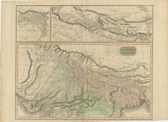
1802 German Map of Kashmir and Surrounding Regions by Weimar, Based on Gentil
Located in Langweer, NL
Jean-Baptiste-Joseph Gentil was a French officer who served at the court of the Nawabs of Awadh, where he conducted diplomatic and geographical studies of India. His accounts signifi...
Paper
$616Sale Price|20% Off
Cartographic Elegance of the Mughal Dominion in a Hand-Colored Antique Map, 1705
Located in Langweer, NL
In more detail: Title: “'T Ryk van den Grooten Mogol” Subject: Northern India Creator: Sanson, Nicolas Date: 1705 (published) Color: Hand Color Size: 9.7 x 7.6 inches (24.6 x 19.3 ...
Paper
$457Sale Price / set|20% Off
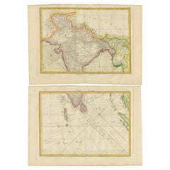
Charting the Course of Empire: Bonne's 1770 Masterpiece Maps of the Indian Ocean
Located in Langweer, NL
More in detail: This is a set of two maps from Rigobert Bonne's 1770 decorative map of India, which were intended for Jean Lattre's Atlas Moderne around 1775.
Paper
$571Sale Price|50% Off
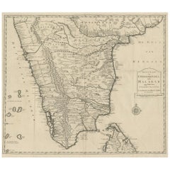
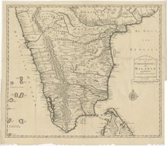
Map of Choromandel & Malabar, Incl Kerala, Tamil Nadu & Part of Sri Lanka, 1726
Located in Langweer, NL
Original antique map of Southern India documenting the VOC's areas of influence.
Paper

Antique Map of Part of the Roman Empire by H. Kiepert, circa 1870
By Heinrich Kiepert
Located in Langweer, NL
Antique map titled 'Imperia Persarum et Macedonum'. Depicts part of the Roman Empire, from Greece to Eastern India.
Paper
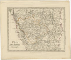
Old Steel Engraved Map of the Western Part of the Madras Presidency, 1831
Located in Langweer, NL
Antique map titled 'India II Madras Presidency'. Old steel engraved map of the western part of the Madras Presidency.
Paper
$287Sale Price|19% Off
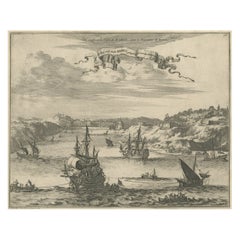
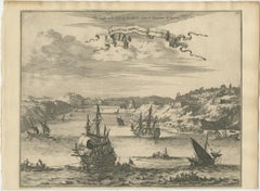
Bird's Eye View of Dabhol as Seen from the Sea, North of Goa, India, 1727
Located in Langweer, NL
Artists and Engravers: Pieter van der Aa Pieter van der Aa (Leiden 1659-1733) was a Dutch publisher best known for preparing maps and atlases. The Galerie Agreable contains plates an...
Paper

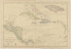
Antique Map of the West Indies and Central America by W. G. Blackie, 1859
Located in Langweer, NL
Antique map titled 'The West India Island & Central America'.
Paper

$2,091Sale Price|20% Off
Rare 18th-Century Hand-Colored Map of Southeast Asia and the East Indies, 1748
Located in Langweer, NL
The map includes India, the Malay Peninsula, the Philippines, Borneo, Sumatra, Java, and parts of China and the Pacific islands, emphasizing the geographic scope of European interest...
Paper
$2,333Sale Price|20% Off
Original Antique Hand-Colored Map of The East Indies and Southeast Asia, c.1644
Located in Langweer, NL
Antique map titled 'India quae Orientalis dicitur, et Insulae adiacentes'.
Paper

Antique Map of the Region Centered on the Malay Peninsula by Tirion 'c.1760'
Located in Langweer, NL
Antique map titled 'Nuova Carta dell' India (..)'. Decorative map of the region centered on the Malay Peninsula and extending from the Straits of Singapore, Malacca and Borneo in the...
Paper
Old Map of Ceylon 'Sri Lanka' with The North Oriented to The Left, 1731
Located in Langweer, NL
The legendary Adams Brug (Adam's Bridge or Rama's Bridge) is clearly shown linking Mannar island off Sri Lanka with Rameswaram island of the coast of India. This map originates from ...
Paper
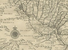
Rare Antique Map of Persia, Incl the Caspian Sea and the Arabian Peninsula, 1726
Located in Langweer, NL
Rare untitled antique map of Persia. It covers from the Gulf of Suez eastward to Ahmedabad (Amadabad) in modern day western India.
Paper
$1,026Sale Price|20% Off
Old Map of Persia, incl the Caspian Sea and Part of the Arabian Peninsula, 1726
Located in Langweer, NL
Antique map of Persia. It covers from the Gulf of Suez eastward to Ahmedabad (Amadabad) in modern day western India.
Paper
$298Sale Price|20% Off
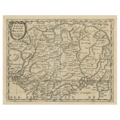
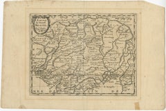
Old Map of the Mughal Empire, Persia in the West to Lake Chimay etc., ca.1685
Located in Langweer, NL
Antique map titled 'L'Empire du Grand Mogol'. Old map of India and Central Asia.
Paper
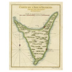
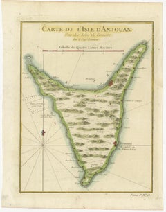
Anjouan Island, Comoros – French Naval Sea Chart by Bellin, c.1765
Located in Langweer, NL
Anjouan was an important stopover between Madagascar, the Swahili Coast, Arabia, and India, and the map is clearly intended for practical navigation rather than purely decorative pur...
Paper


$345Sale Price|20% Off
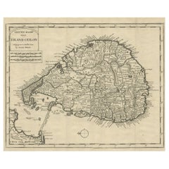
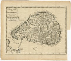
Ancient Cartography of the Indian Subcontinent, Published in 1880
Located in Langweer, NL
This map is titled "INDIA," and it provides a detailed view of the Indian subcontinent with various inset maps that offer additional historical and geographical context.
Paper
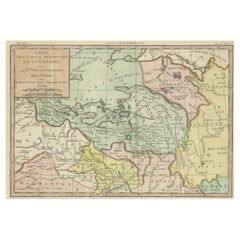
18th Century Hand-Colored Antique Map of Tartary and Northern India
Located in Langweer, NL
The map translates to "Map of the Southern Part of Tartary with the Northern Part of India."
Paper

India (Southern Sheet), English antique map by Alexander Keith Johnston, 1901
By Alexander Keith Johnston 1
Located in Melbourne, Victoria
'India (Southern Sheet)', antique lithographic map by Keith Johnston.
Lithograph
Antique and vintage collectibles and curiosities can bring whimsy and wonder to any interior.
Decorating with old scientific instruments, historical memorabilia and vintage musical instruments, as well as other authentic collectibles and curiosities that can be found on 1stDibs, presents an opportunity to create a unique, natural history museum-like atmosphere in your home that can provoke conversation as often as it pays tribute to how far we’ve come in understanding our world.
And bringing collectibles and curiosities into your space is actually on trend — Wunderkammern, or curiosity cabinets, were all the rage in Europe during the 1500s and continued to have adherents there and in the U.S. in the following centuries. Today, however, they’re experiencing a real surge in popularity and influencing how many interior designers are furnishing and decorating homes — combining contemporary with antique, scientific with tribal, earthly with extraterrestrial, Les Lalanne tables with Flemish tapestries.
The original Wunderkammern were entire rooms filled with objects demonstrating their owners’ worldly knowledge: A proper one included artificiala or preciosa (objets d’art); naturalia (such as skeletons, shells, minerals); exotica (taxidermy or dried plants); and scientifica (scientific instruments), frequently alongside religious relics and ancient artifacts.
Pay tribute to a history of rich and diverse musical traditions that have taken shape all over the world by decorating your home with a collection of antique and vintage musical instruments — with a little help from strong hanging wire or some wall hooks, vintage brass instruments such as a gong, French horn or trumpet can help elevate a home office or complement the efforts you’ve made to ensure a welcoming vibe in your home’s entryway. Bells or antique wind instruments can add provocative metallic contrasts to dark woods as tabletop decorative objects.
Create an intriguing focal point with Georgian scientific instruments, such as stick barometers with mahogany cases or lacquered brass telescopes. These items stem from an era named for the monarchies of the four King Georges, who ruled England in succession starting in 1714 (plus King William’s reign, which lasted until 1837). Just as there was beautiful jewelry produced during the period that today is coveted by collectors, there is much to be found in the collectibles and curiosities realm too.
Wanderlust, nostalgia and a shared love of good design are contributing factors to certain trends in decorating — just as vintage trunks and luggage have reappeared as furniture or home accents in a bedroom or foyer, decorating with globes, maps or nautical objects is similarly rooted in the allure of travel and a penchant for the stylish finishing touch that collectibles bring to our homes.
Find a wide range of antique and vintage collectibles and curiosities on 1stDibs.
It's hard to resist the allure of a beautiful pool. So, go ahead and daydream about whiling away your summer in paradise.
It’s never too early for good design. These interiors combine elevated furnishings and a youthful spirit, resulting in spaces that are at once elegant and whimsical.
Produced in 1843, the well-preserved volume is evidence of the author's exacting specifications.
New or old, the coverlets add old-time charm to any space.
Get into the games! These items celebrate the events, athletes, host countries and sporting spirit.
French trendsetter and serial collector Daniel Rozensztroch tells us about his obsession with objects related to seafaring men.
The sought-after designer worked with the team at Hoffman Creative to produce a monograph that beautifully showcases some of Studio Shamshiri's most inspiring projects.
Italian writer and collector Umberto Pasti opens the doors to his remarkable cave of wonders in North Africa.