Items Similar to Ancient World Map of Europe, Asia & Northern Africa with Ancient Names, 1725

Want more images or videos?
Request additional images or videos from the seller
1 of 6
Ancient World Map of Europe, Asia & Northern Africa with Ancient Names, 1725
$1,122.95
$1,496.4724% Off
£828.35
£1,103.8824% Off
€938
€1,25024% Off
CA$1,555.90
CA$2,073.4324% Off
A$1,688.39
A$2,249.9924% Off
CHF 894.70
CHF 1,192.3024% Off
MX$20,707.31
MX$27,595.0324% Off
NOK 11,071.84
NOK 14,754.5824% Off
SEK 10,462.30
SEK 13,942.3024% Off
DKK 7,142.69
DKK 9,518.5124% Off
About the Item
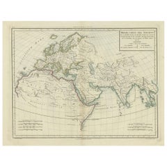
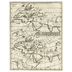
Antique map titled 'Geografische Kaarte van de Oude Weereld (..).'
Original antique map of the ancient world depicting Europe, Asia, and northern Africa with ancient place names. This map originates from volume 1 of 'Het algemeen groot historisch, oordeelkundig, chronologisch, geografisch, en letterlyk naam- en woord-boek, van den gantschen H. Bybel (..)' by AS. Calmet.
Artists and engravers: Author: Antoine Augustin Calmet (1672-1757), French Benedictine. Published by Samuel Luchtmans, 1725.
- Dimensions:Height: 15.75 in (40 cm)Width: 18.51 in (47 cm)Depth: 0 in (0.02 mm)
- Materials and Techniques:
- Period:1720-1729
- Date of Manufacture:1725
- Condition:Wear consistent with age and use. Condition: Good, given age. Edges browned and with a few tiny tears, not affecting image. A few tiny spots. Original middle fold as issued. General age-related toning and/or occasional minor defects from handling. Please study image carefully.
- Seller Location:Langweer, NL
- Reference Number:Seller: PCT-61441 1stDibs: LU3054326942352
About the Seller
5.0
Recognized Seller
These prestigious sellers are industry leaders and represent the highest echelon for item quality and design.
Platinum Seller
Premium sellers with a 4.7+ rating and 24-hour response times
Established in 2009
1stDibs seller since 2017
2,622 sales on 1stDibs
Typical response time: <1 hour
- ShippingRetrieving quote...Shipping from: Langweer, Netherlands
- Return Policy
Authenticity Guarantee
In the unlikely event there’s an issue with an item’s authenticity, contact us within 1 year for a full refund. DetailsMoney-Back Guarantee
If your item is not as described, is damaged in transit, or does not arrive, contact us within 7 days for a full refund. Details24-Hour Cancellation
You have a 24-hour grace period in which to reconsider your purchase, with no questions asked.Vetted Professional Sellers
Our world-class sellers must adhere to strict standards for service and quality, maintaining the integrity of our listings.Price-Match Guarantee
If you find that a seller listed the same item for a lower price elsewhere, we’ll match it.Trusted Global Delivery
Our best-in-class carrier network provides specialized shipping options worldwide, including custom delivery.More From This Seller
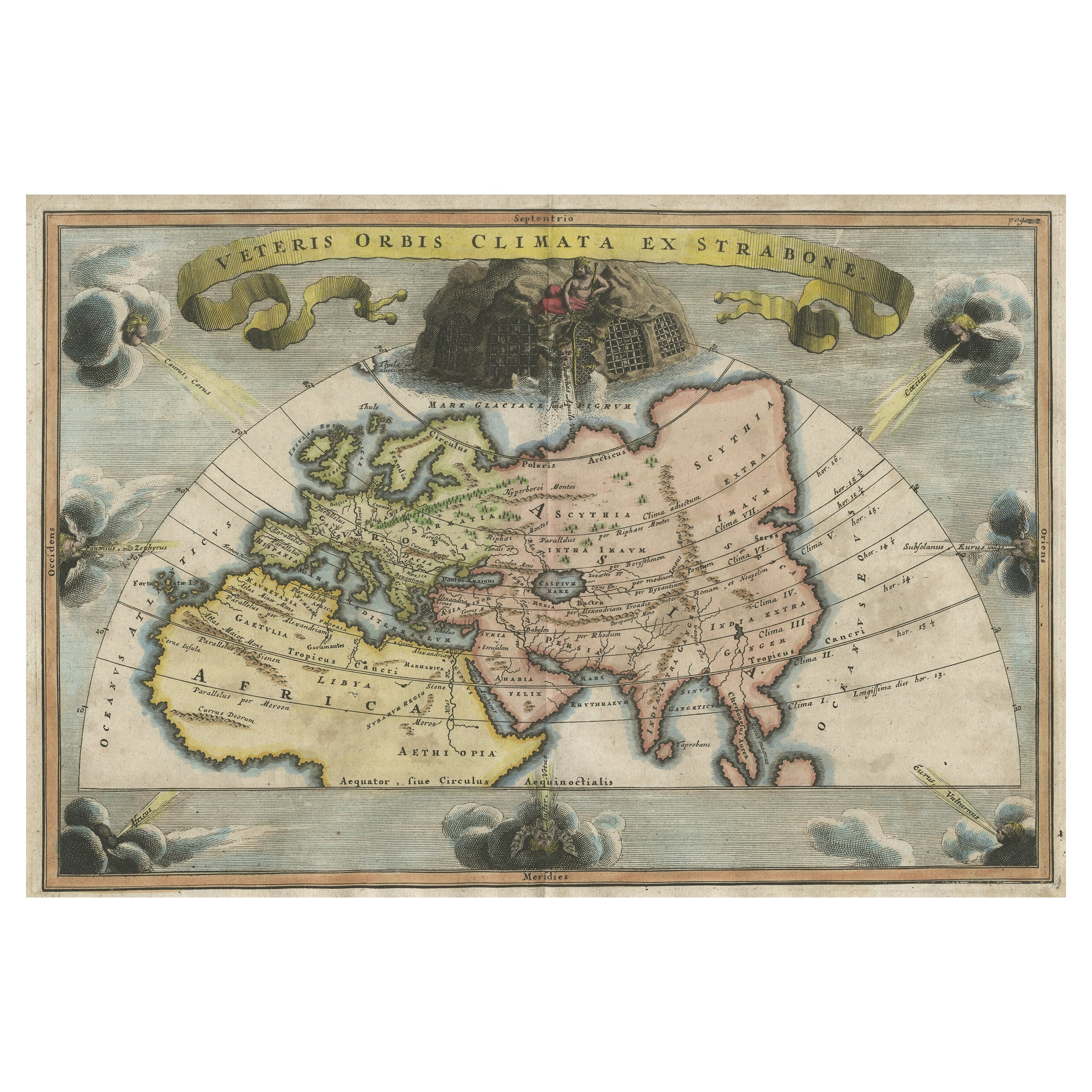
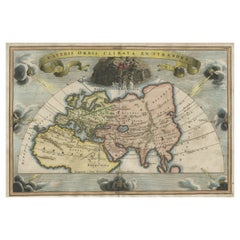
View AllVeteris Orbis Climata – Ancient World Map after Strabo by Cellarius, 1731
Located in Langweer, NL
Veteris Orbis Climata – Ancient World Map after Strabo by Cellarius, 1731
This fascinating hand-colored antique map, titled Veteris Orbis Climata ex...
Category
Antique 1730s Maps
Materials
Paper
$430 Sale Price
20% Off
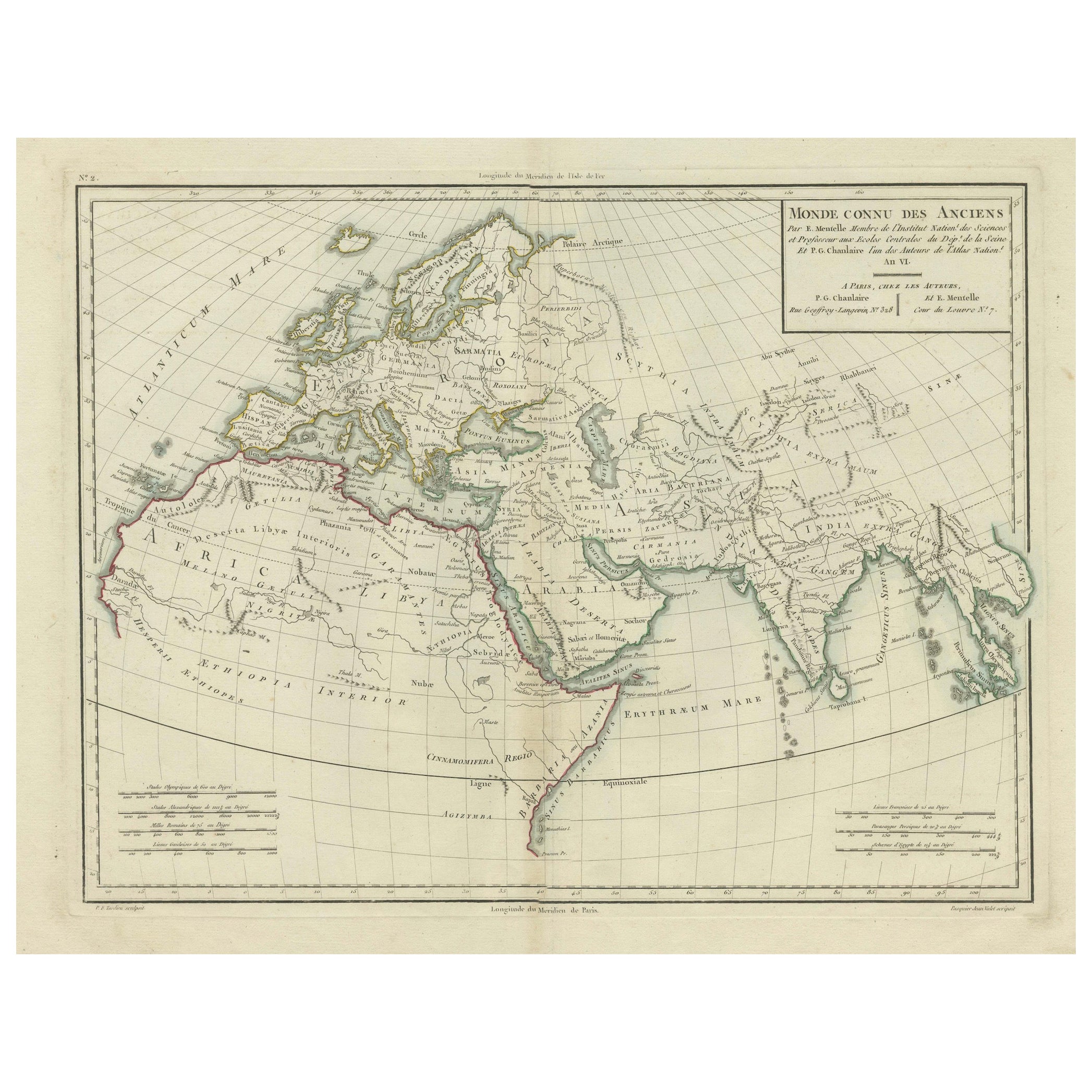
Ancient World Map: Europe, Africa & Asia - 1802 Tardieu Atlas
Located in Langweer, NL
Antique Map Description with title: "Monde Connu Des Anciens"
Publication Details:
- Atlas Title: Nouvel Atlas Universel de Géographie Ancienne et Moderne
- Purpose: For the Nouvel...
Category
Antique Early 1800s Maps
Materials
Paper
$421 Sale Price
20% Off
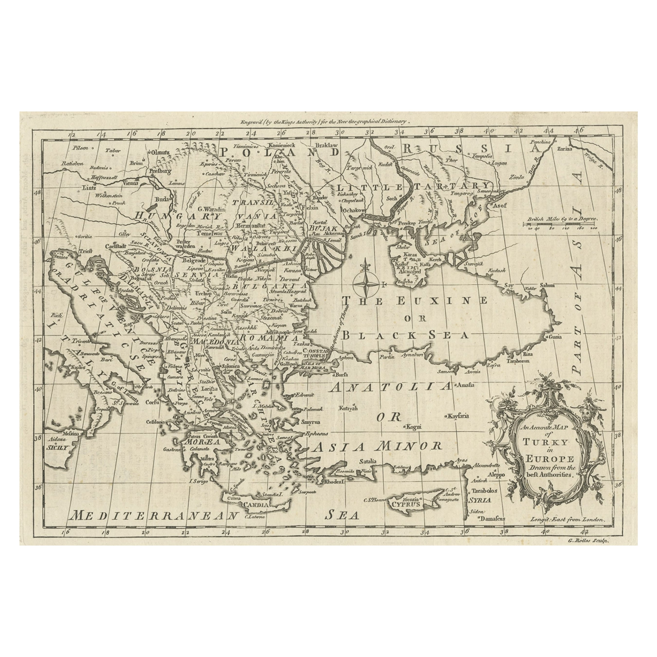
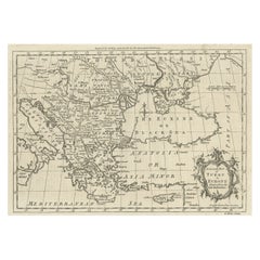
Map of the Ottoman Empire in Europe, incl. the Balkans, Greece & Turkey, c.1760
Located in Langweer, NL
Antique map Turkey titled 'An Accurate Map of Turky in Europe drawn from the best Authorities'.
Map of the Ottoman Empire in Europe, the Balkans, Greece, and Turkey in Europe. Engr...
Category
Antique 1760s Maps
Materials
Paper
$440 Sale Price
20% Off
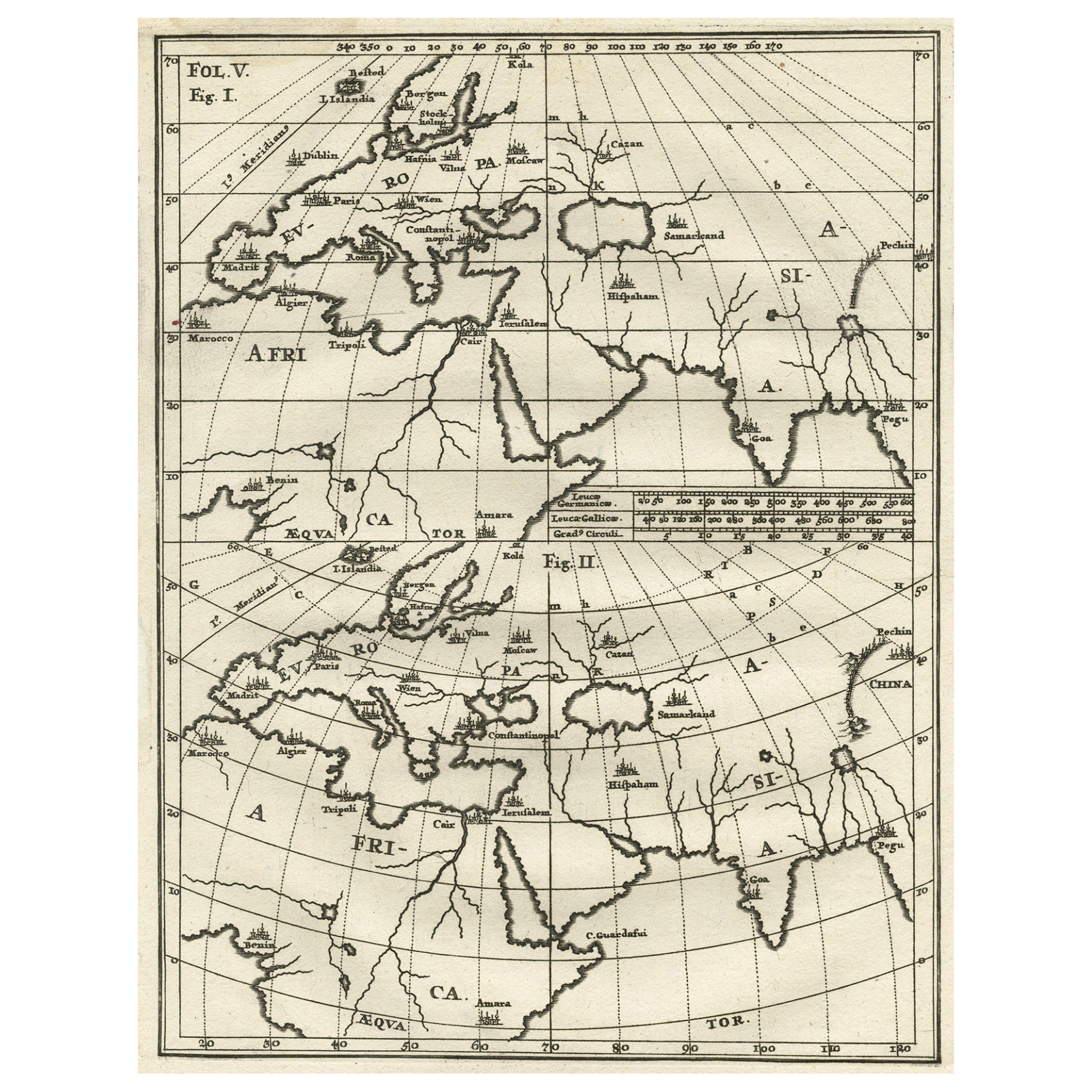
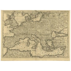
Intriguing Antique Map of Europe, Asia and Africa by Scherer, c.1703
Located in Langweer, NL
Two maps on a single sheet showing Europe, Asia and Africa, each depicting nearly the same area. On close examination there are slight differences. Major cities are located. Printed ...
Category
Antique 18th Century German Maps
Materials
Paper
Finely Engraved Historical Map of Middle East and Asia, c.1745
Located in Langweer, NL
Description: Antique map titled'Theatrum Historicum pars Orientalis.'
Finely engraved historical map with a profusion of details. It shows the Middle East and Asia. Decorative ti...
Category
Antique 1740s Maps
Materials
Paper

$1,388 Sale Price
20% Off
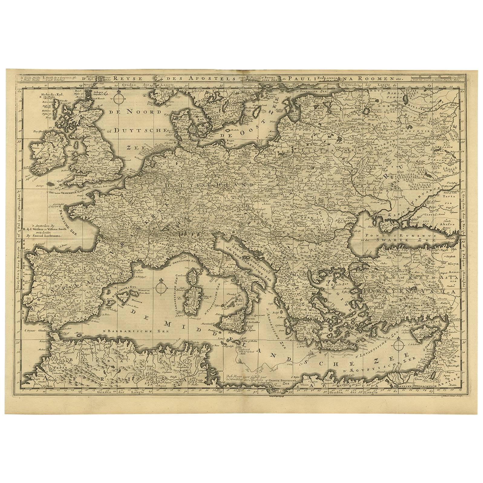
Rare Antique Bible Map of Southern Europe by A. Schut, 1743
Located in Langweer, NL
Antique map of the Mediterranean and a large part of Europe, illustrating the voyage of St. Paul to Rome. This map originates from ‘Biblia Sacra, dat is, de H. Schriftuer van het Oud...
Category
Antique Mid-18th Century Maps
Materials
Paper
$519 Sale Price
33% Off
You May Also Like
1718 Ides & Witsen Map "Route D'amsterdam a Moscow Et De La Ispahan Et Gamron
Located in Norton, MA
1718 Ides & Witsen map, entitled
"Route D'Amsterdam A Moscow Et De La Ispahan Et Gamron,"
Ric.b005
Subject: Eastern Europe and Central Asia
Period: 1718 (published)
Publicati...
Category
Antique Early 18th Century Dutch Maps
Materials
Paper

17th Century Nicolas Visscher Map of Southeastern Europe
Located in Hamilton, Ontario
A beautiful, highly detailed map of southeastern Europe by Nicolas Visscher. Includes regions of Northern Italy (showing the cities Bologna, Padua, and Venice), Bohemia, Austria (sho...
Category
Antique 17th Century Dutch Maps
Materials
Paper

$1,350 Sale Price
38% Off
Vintage Reproduction 17th Century Map of Europe, American, Cartography, Blaeuw
Located in Hele, Devon, GB
This is a vintage reproduction map of Europe. An American, paper stock cartography print in frame after the work by Blaeuw, dating to the late 20t...
Category
Late 20th Century Central American Mid-Century Modern Maps
Materials
Glass, Wood, Paper

Antique French Map of Asia Including China Indoneseia India, 1783
Located in Amsterdam, Noord Holland
Very nice map of Asia. 1783 Dedie au Roy.
Additional information:
Country of Manufacturing: Europe
Period: 18th century Qing (1661 - 1912)
Condition: Overall Condition B (Good Used)...
Category
Antique 18th Century European Maps
Materials
Paper

$648 Sale Price
20% Off
Europe: An Original 18th Century Hand-colored Map by E. Bowen
Located in Alamo, CA
This is an original 18th century hand-colored map entitled "A New & Accurate Map of Europe Drawn from the Best Authorities Assisted by the Most Improved Modern Charts and Maps." by E...
Category
Mid-18th Century Old Masters Landscape Prints
Materials
Engraving

17th Century Map of Denmark by French Cartographer Sanson, Dated 1658
By Nicolas Sanson
Located in Copenhagen, K
17th century map of Denmark by French cartographer Sanson.
Nicolas Sanson (20 December 1600-7 July 1667) was a French cartographer, termed by some the creator of French geography an...
Category
Antique 17th Century French Maps
Materials
Paper

More Ways To Browse
Names Of Antique Furniture
Antique Florida Map
Antique Map Chile
Antique Map Of Georgia
Antique Mississippi Furniture
Burgundy Map
John Speed Antique Maps
Malabar Map
Malaysia Map
Map Of Syria
Taiwan Map
Antique Chicago Maps
Dutch Bible
New Jersey 19th Century
Thailand Map
Antique Coal Mining
Antique Dutch Bible
Antique Louisiana Map