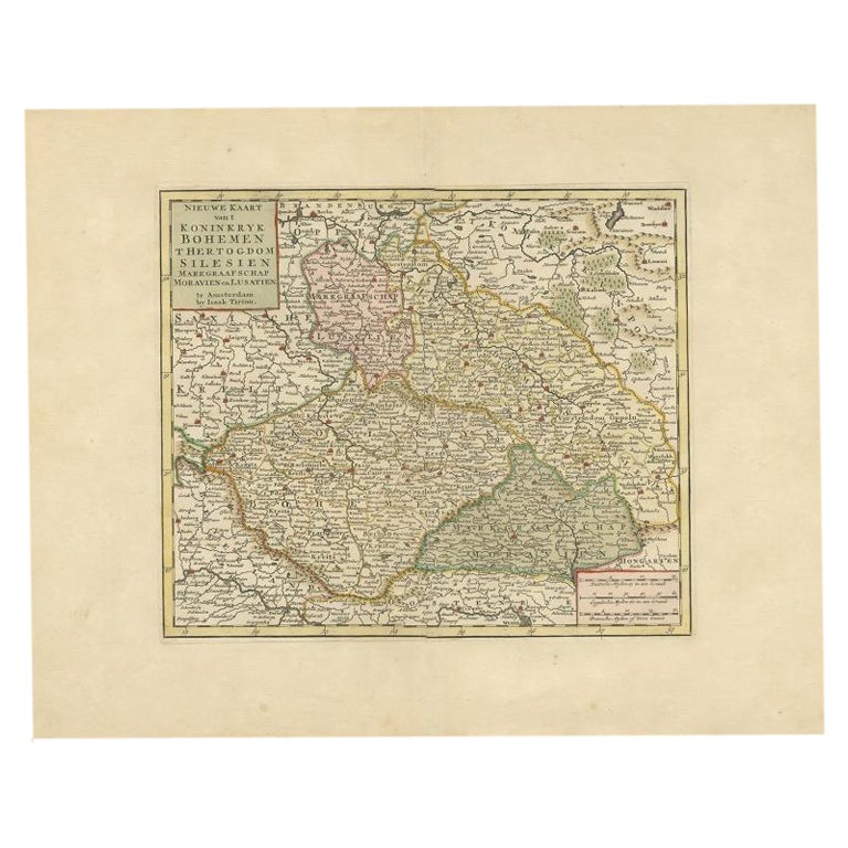
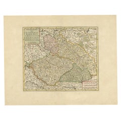
Items Similar to Antique Map of the Kingdom of Bohemia by Keizer & de Lat, 1788


Want more images or videos?
Request additional images or videos from the seller
1 of 5
Antique Map of the Kingdom of Bohemia by Keizer & de Lat, 1788
$334.77
$418.4720% Off
£247.83
£309.7920% Off
€280
€35020% Off
CA$463.24
CA$579.0520% Off
A$510.71
A$638.3920% Off
CHF 267.19
CHF 333.9920% Off
MX$6,265.50
MX$7,831.8720% Off
NOK 3,363.37
NOK 4,204.2220% Off
SEK 3,145.29
SEK 3,931.6120% Off
DKK 2,132.87
DKK 2,666.0920% Off
About the Item
Antique map titled 't Koninkryk Bohemen (..)'. Uncommon original antique map of the Kingdom of Bohemia. This map originates from 'Nieuwe Natuur- Geschied- en Handelkundige Zak- en Reisatlas' by Gerrit Brender à Brandis. Published by J. Keizer and I. de Lat, 1788.
- Dimensions:Height: 8.08 in (20.5 cm)Width: 10.63 in (27 cm)Depth: 0.02 in (0.5 mm)
- Materials and Techniques:
- Period:
- Date of Manufacture:1788
- Condition:General age-related toning. Original folding lines. Original/contemporary hand coloring, blank verso. Minor wear, please study image carefully.
- Seller Location:Langweer, NL
- Reference Number:Seller: BG-12854-261stDibs: LU3054321978512
About the Seller
5.0
Recognized Seller
These prestigious sellers are industry leaders and represent the highest echelon for item quality and design.
Platinum Seller
Premium sellers with a 4.7+ rating and 24-hour response times
Established in 2009
1stDibs seller since 2017
2,609 sales on 1stDibs
Typical response time: <1 hour
- ShippingRetrieving quote...Shipping from: Langweer, Netherlands
- Return Policy
Authenticity Guarantee
In the unlikely event there’s an issue with an item’s authenticity, contact us within 1 year for a full refund. DetailsMoney-Back Guarantee
If your item is not as described, is damaged in transit, or does not arrive, contact us within 7 days for a full refund. Details24-Hour Cancellation
You have a 24-hour grace period in which to reconsider your purchase, with no questions asked.Vetted Professional Sellers
Our world-class sellers must adhere to strict standards for service and quality, maintaining the integrity of our listings.Price-Match Guarantee
If you find that a seller listed the same item for a lower price elsewhere, we’ll match it.Trusted Global Delivery
Our best-in-class carrier network provides specialized shipping options worldwide, including custom delivery.More From This Seller
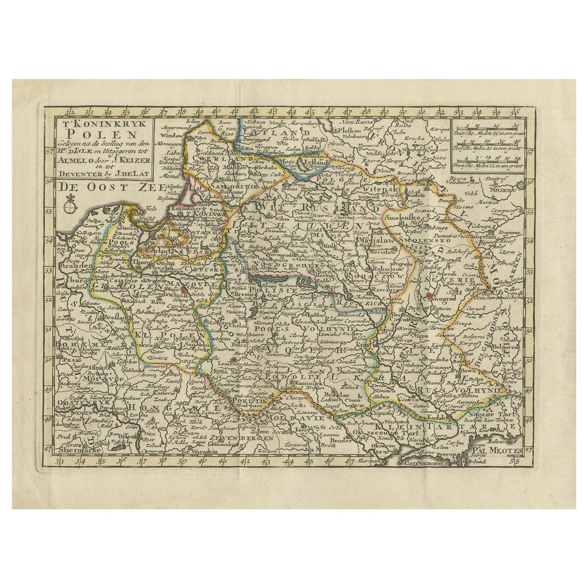
View AllAntique Map of the Kingdom of Poland by Keizer & de Lat, 1788
Located in Langweer, NL
Antique map titled 't Koninkryk Polen (..)'. Uncommon original antique map of the Kingdom of Poland. This map originates from 'Nieuwe Natuur- Geschied- en Handelkundige Zak- en Reisa...
Category
Antique Late 18th Century Maps
Materials
Paper
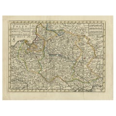
$334 Sale Price
20% Off
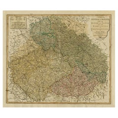
Antique Map of Bohemia in the Present-Day Chech Repubic, 1730
Located in Langweer, NL
Antique map titled 'Nieuwe Kaart van t Koninkryk Bohemen t Hertogdom Silesien markgraafschap Moravien (Moravia) en Lusatien' (Lusatia). Map of Bohemia (Czech Republic) with the surro...
Category
Antique 18th Century Maps
Materials
Paper
$526 Sale Price
20% Off
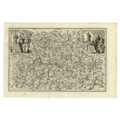
Antique Map of the Kingdom of Hungary by Keizer & de Lat, 1788
Located in Langweer, NL
Antique map titled 't Koninkryk Hongarien (..)'. Uncommon original antique map of the Kingdom of Hungary. This map originates from 'Nieuwe Natuur- Geschied- en Handelkundige Zak- en ...
Category
Antique Late 18th Century Maps
Materials
Paper

$334 Sale Price
20% Off
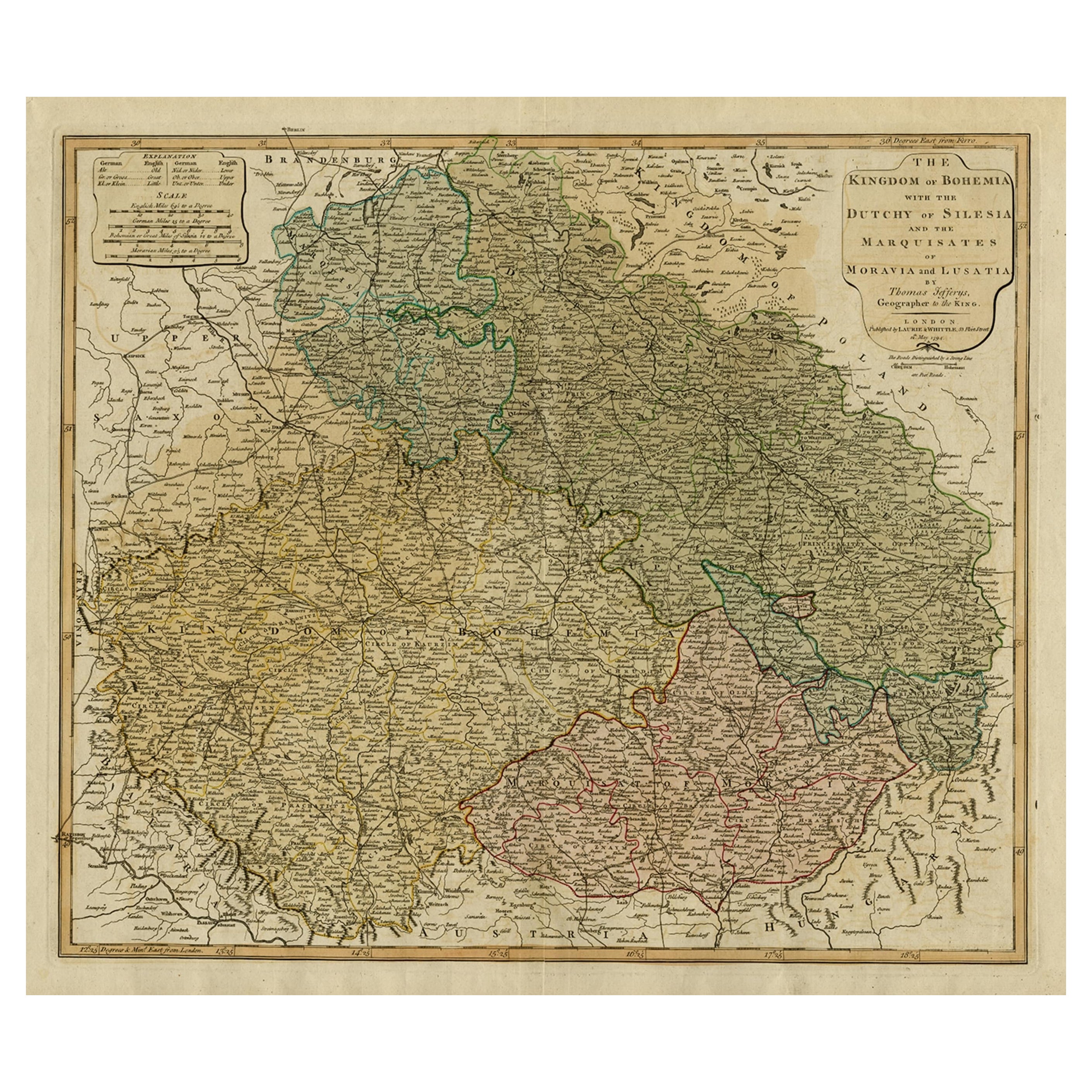
Original Map of the Kingdom of Bohemia, with Silesia, Moravia and Lusatia, 1804
Located in Langweer, NL
Antique map titled 'The Kingdom of Bohemia with the Duchy of Silesia and the Marquisates of Moravia and Lusatia.'
Map of the Kingdom of Bohemia, with Silesia, Moravia and Lusatia...
Category
Antique Early 1800s Maps
Materials
Paper
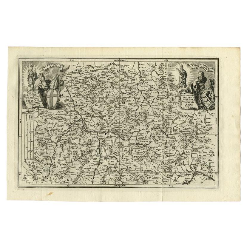
Antique Map of the Franconia Region by Scherer, 1699
Located in Langweer, NL
Antique map titled 'Franconia multa numerat loca deiparae sacra in quibus magna recipit à dei matre beneficia.' Detailed uncommon map of the Franconia region in Germany. Source unkno...
Category
Antique 17th Century Maps
Materials
Paper
$215 Sale Price
20% Off
Antique Map of the County of Hainaut by Jaillot, 1692
Located in Langweer, NL
Antique map titled 'Le Comté de Haynaut divisé en Chateliensis, Balliages, Prevoste's (..)'. Large map of the county of Hainaut (France) with its most important cities, Mons (Bergen)...
Category
Antique 17th Century Maps
Materials
Paper

$213 Sale Price
20% Off
You May Also Like
1752 Vaugoundy Map of Flanders : Belgium, France, and the Netherlands, Ric.a002
Located in Norton, MA
Large Vaugoundy Map of Flanders:
Belgium, France, and the Netherlands
Colored -1752
Ric.a002
Description: This is a 1752 Didier Robert de Vaugondy map of Flanders. The map de...
Category
Antique 17th Century Unknown Maps
Materials
Paper

18th Century Emanuel Bowen Map of County of York, c.1740
By Emanuel Bowen
Located in Royal Tunbridge Wells, Kent
Antique 18th century British rare and original Emanuel Bowen (1694-1767) map of the County of York divided into its Ridings and subdivided into wapontakes, mounted in solid wood fram...
Category
Antique Early 18th Century British Maps
Materials
Paper

West Germany: Original Hand Colored 17th Century Map by Johannes Janssonius
By Johannes Janssonius
Located in Alamo, CA
An original hand colored copperplate engraved map entitled in Latin "Archiepiscopatus Maghdeburgensis et Anhaltinus Ducatus cum terris adjacentibus", published in Amsterdam in 1640 i...
Category
Mid-17th Century Old Masters More Prints
Materials
Engraving

1771 Bonne Map of Poitou, Touraine and Anjou, France, Ric.a015
Located in Norton, MA
1771 Bonne Map of Poitou,
Touraine and Anjou, France
Ric.a015
1771 Bonne map of Potiou, Touraine and Anjou entitled "Carte des Gouvernements D'Anjou et du Saumurois, de la Touraine, du Poitou,du Pays d'aunis, Saintonge?Angoumois,"
Carte des gouvernements d'Anjou et du Saumurois, de la Touraine, du Poitou, du Pays d'Aunis, Saintonge-Angoumois. Projettee et assujettie au ciel par M. Bonne, Hyd. du Roi. A Paris, Chez Lattre, rue St. Jacques a la Ville de Bord(ea)ux. Avec priv. du Roi. 1771. Arrivet inv. & sculp., Atlas moderne ou collection de cartes sur toutes...
Category
Antique 17th Century Unknown Maps
Materials
Paper

1853 Map of "Russia in Europe Including Poland" Ric.r016
Located in Norton, MA
Description
Russia in Europe incl. Poland by J Wyld c.1853
Hand coloured steel engraving
Dimension: Paper: 25 cm W x 33 cm H ; Sight: 22 cm W x 28 cm H
Condition: Good ...
Category
Antique 19th Century Unknown Maps
Materials
Paper

1635 Willem Blaeu Map of Northern France"Comitatvs Bellovacvm" Ric.a08
Located in Norton, MA
1635 Willem Blaeu map of northern France, entitled.
"Comitatvs Bellovacvm Vernacule Beavvais,"
Colored
Ric.a008
“COMITATVS BELLOVACVM…” Amsterdam: W...
Category
Antique 17th Century Unknown Maps
Materials
Paper

More Ways To Browse
Antique Kingdom
Scotland Map
Old School Maps
Antique Map Of Middle East
Joan Blaeu
New Zealand Map
Antique Galleon
Used Nautical Charts
Antique Maps Australia
Medieval Capital
Map Of Singapore
Roman Empire Map
Antique Railroad Furniture
Migeon Migeon
Antique Collectables Australia
Antique Maps Of New York City
Antique Maps Of Greece
Antique Railroad Maps