Items Similar to Antique Map of The Siege of Gennep, the Netherlands, c.1650

Want more images or videos?
Request additional images or videos from the seller
1 of 6
Antique Map of The Siege of Gennep, the Netherlands, c.1650
$228.22
$285.2720% Off
£169.95
£212.4420% Off
€192
€24020% Off
CA$315.08
CA$393.8520% Off
A$349.32
A$436.6520% Off
CHF 183.58
CHF 229.4720% Off
MX$4,275.06
MX$5,343.8320% Off
NOK 2,292.72
NOK 2,865.9020% Off
SEK 2,151.95
SEK 2,689.9420% Off
DKK 1,461.82
DKK 1,827.2820% Off
About the Item
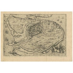
Antique map titled 'Belagerung des Besten Schloss und Passes Gennep'. Old map of the Siege of Gennep, the Netherlands. This map originates from 'Theatrum Europaeum' by M. Merian. Artists and Engravers: Matthäus Merian, engraver, etcher, and book dealer, the leading German illustrator of the 17th century.
Map of Gennep at the time of the siege by the Dutch army under Frederik Hendrik in 1641 during the Eighty Years’ War. Left the town of Gennep, in the center the stronghold Genneperhuis, along the river Maas. In the surrounding landscape the fortifications are indicated, accompanied by brief descriptions. (Belägerung des Vests schloss{...} Passes Gennep; Obsidio Geneappae). 6 June - July 27, 1641. With the circles of citizen's circumlection and their army camps. Bottom left on a pedestal The legend A-C in German.
Artist: Matthäus Merian, engraver, etcher, and book dealer, the leading German illustrator of the 17th century.
Condition: Good, general age-related toning. Some staining with a bigger stain in the lower middle, but outside the image. Please study image carefully.
Date: c.1650
Overall size: 40 x 32 cm.
Image size: 36 x 27 cm.
We sell original antique maps to collectors, historians, educators and interior decorators all over the world. Our collection includes a wide range of authentic antique maps from the 16th to the 20th centuries. Buying and collecting antique maps is a tradition that goes back hundreds of years. Antique maps have proved a richly rewarding investment over the past decade, thanks to a growing appreciation of their unique historical appeal. Today the decorative qualities of antique maps are widely recognized by interior designers who appreciate their beauty and design flexibility. Depending on the individual map, presentation, and context, a rare or antique map can be modern, traditional, abstract, figurative, serious or whimsical. We offer a wide range of authentic antique maps for any budget.
- Dimensions:Height: 12.6 in (32 cm)Width: 15.75 in (40 cm)Depth: 0 in (0.01 mm)
- Materials and Techniques:
- Period:
- Date of Manufacture:circa 1650
- Condition:
- Seller Location:Langweer, NL
- Reference Number:Seller: BG-121471stDibs: LU3054326345802
About the Seller
5.0
Recognized Seller
These prestigious sellers are industry leaders and represent the highest echelon for item quality and design.
Platinum Seller
Premium sellers with a 4.7+ rating and 24-hour response times
Established in 2009
1stDibs seller since 2017
2,609 sales on 1stDibs
Typical response time: <1 hour
- ShippingRetrieving quote...Shipping from: Langweer, Netherlands
- Return Policy
Authenticity Guarantee
In the unlikely event there’s an issue with an item’s authenticity, contact us within 1 year for a full refund. DetailsMoney-Back Guarantee
If your item is not as described, is damaged in transit, or does not arrive, contact us within 7 days for a full refund. Details24-Hour Cancellation
You have a 24-hour grace period in which to reconsider your purchase, with no questions asked.Vetted Professional Sellers
Our world-class sellers must adhere to strict standards for service and quality, maintaining the integrity of our listings.Price-Match Guarantee
If you find that a seller listed the same item for a lower price elsewhere, we’ll match it.Trusted Global Delivery
Our best-in-class carrier network provides specialized shipping options worldwide, including custom delivery.More From This Seller
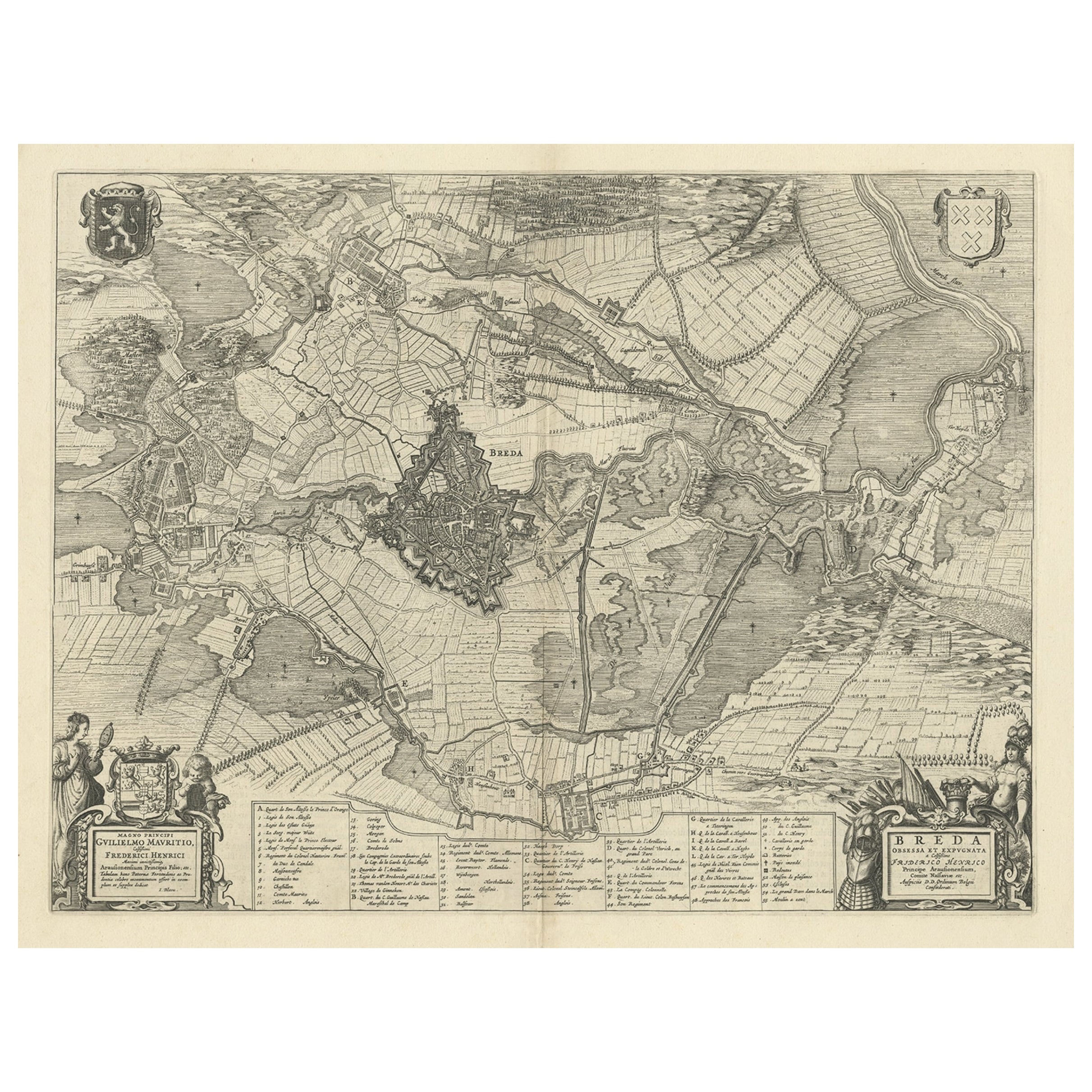
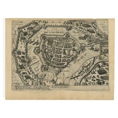
View AllAntique Map of the Siege of Breda, City in the Netherlands by Blaeu, 1649
Located in Langweer, NL
Antique map titled 'Breda obsessa et expugnata a Celsissimo Frederico Henrico'.
Old map of the city of Breda, the Netherlands. It shows the Siege of Breda in 1637. Originates fro...
Category
Antique 17th Century Maps
Materials
Paper
$798 Sale Price
20% Off
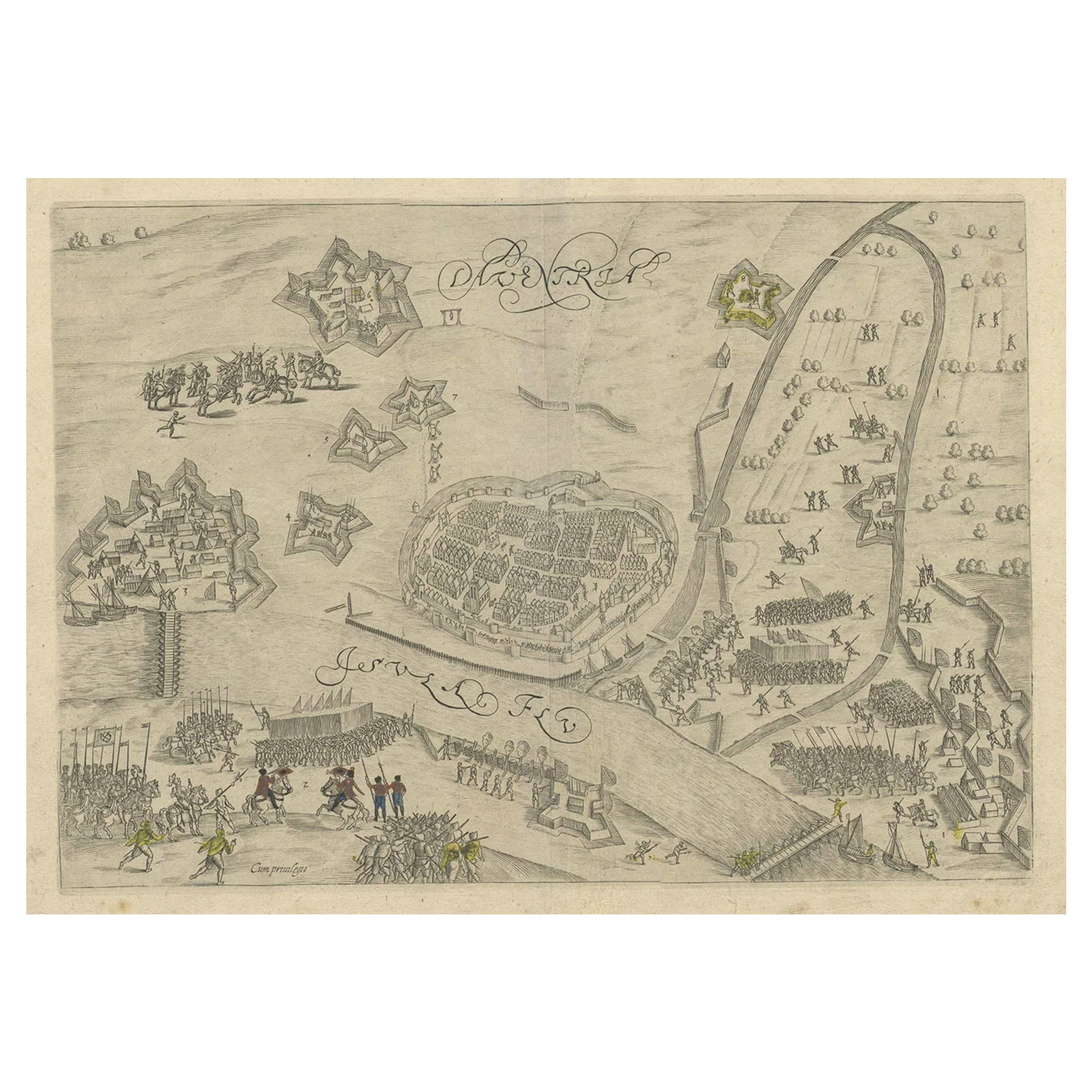
Antique Map of the 1591 Siege and Occupation of Deventer City, Holland, c1610
Located in Langweer, NL
Antique map titled 'Daventria'. Old map of the city of Deventer, the Netherlands. The print illustrates the siege and occupation of Deventer by the State army under command of prince...
Category
Antique 17th Century Maps
Materials
Paper
$361 Sale Price
20% Off
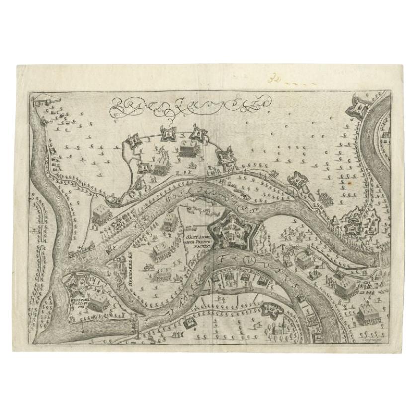
Antique Map of St. Andries 'Heerewaarden' by Orlers, 1615
Located in Langweer, NL
Antique map titled 'Prata Inundata'. This map depicts the area between the Maas and Waal river (The Netherlands) during the siege of St. Andries and Voorne under command of prince Ma...
Category
Antique 17th Century Maps
Materials
Paper
$170 Sale Price
20% Off
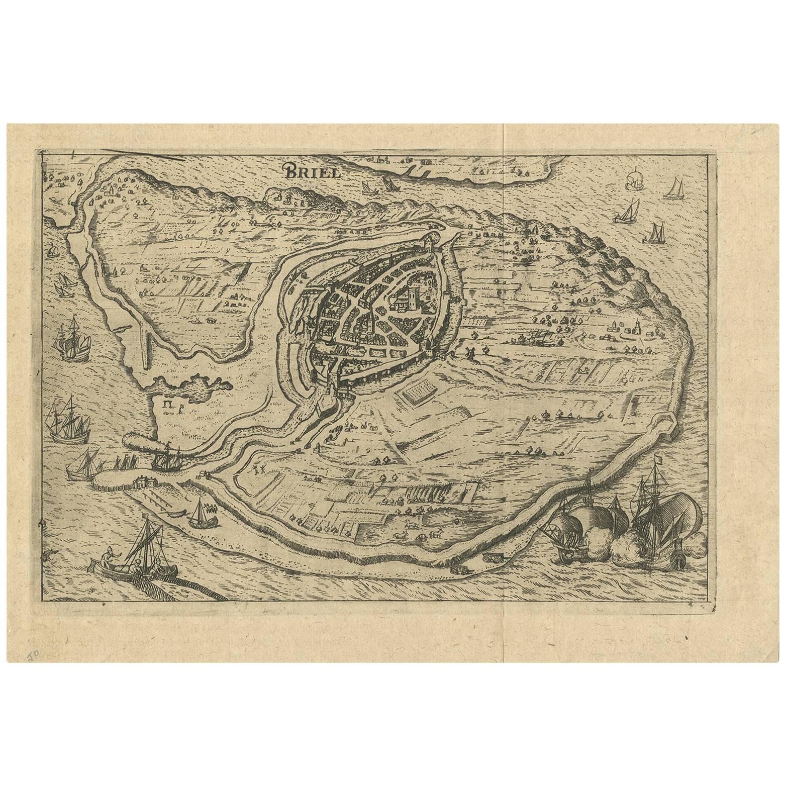
Antique Map of the City of Brielle 'The Netherlands' by L. Guicciardini, 1625
Located in Langweer, NL
Plan of Brielle, Briel, Den Briel in the Province of Zuid-Holland, The Netherlands, Holland. This map originates from the 1625 edition of 'Discrittione di tutti i Paesi Bassi', by L....
Category
Antique Early 17th Century Maps
Materials
Paper
$171 Sale Price
20% Off
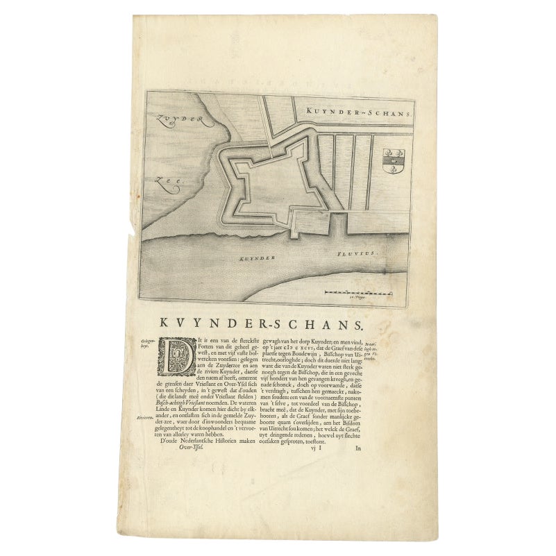
Antique Map of Kuinderschans, Part of the Frisian Defense Line, Netherlands 1649
Located in Langweer, NL
Antique Dutch map titled 'Kuynder-Schans'. Old map of the 'Kuinderschans', a rampart to block passage over the Zuiderzeedijk and prevent an attack from the waterside.
The buildin...
Category
Antique 17th Century Maps
Materials
Paper

$171 Sale Price
20% Off
Antique Plan of Grave, The Netherlands, Showing the Siege of Grave in 1602
Located in Langweer, NL
Antique map titled 'Die Stat Grave' Bird's eye view plan of Grave, The Netherlands, Holland. Showing the siege of Grave in the year 1602 by Prince Maurits of The Netherlands. Source ...
Category
Antique 16th Century Maps
Materials
Paper
$418 Sale Price
20% Off
You May Also Like
Map of the Netherlands - Etching by G. Braun and F. Hogenberg -Late 16th Century
By Franz Hogenberg
Located in Roma, IT
Map of the Netherlands is an original etching realized by George Braun and Franz Hogenberg, as part of the "Civitates Orbis Terrarum".
The “Civitates Orbis Terrarum” (Atlas of Citi...
Category
16th Century Figurative Prints
Materials
Etching

17th Century Toulouse, Savve, Sommieres Topographical Map by Iohan Peeters
Located in New York, NY
Fine topographical 17th century map of Toulouse, Savve and Sommieres by Iohan Peeters
Beautiful engraving of the capital of France's Occitanie Region, Toulouse, called La Ville Rose- the Pink City, for the terracotta bricks used in its many buildings, giving the city a distinct apricot-rose hue. An important cultural and educational center, the city's residents included Nobel Prize winners and world renown artists- Henri de Toulouse-Lautrec, Henri Martin, Jean-Auguste-Dominique Ingres, Antonin Mercie, Alexandre Falguiere and more recently Cyril Kongo...
Category
Antique 17th Century Dutch Maps
Materials
Paper

1657 Janssonius Map of Vermandois and Cappelle, Ric. A-004
Located in Norton, MA
1657 Janssonius map of
Vermandois and Cappelle
Ric.a004
Description: Antique map of France titled 'Descriptio Veromanduorum - Gouvernement de la Cappelle'. Two detailed maps o...
Category
Antique 17th Century Unknown Maps
Materials
Paper

1635 Willem Blaeu Map of Northern France"Comitatvs Bellovacvm" Ric.a08
Located in Norton, MA
1635 Willem Blaeu map of northern France, entitled.
"Comitatvs Bellovacvm Vernacule Beavvais,"
Colored
Ric.a008
“COMITATVS BELLOVACVM…” Amsterdam: W...
Category
Antique 17th Century Unknown Maps
Materials
Paper

1630 Pierre Petit map "Description du Gouvernement de la Capelle" Ric0010
Located in Norton, MA
1630 Pierre Petit map entitled
"Description du Gouvernement de la Capelle,"
Ric0010
Pierre Petit was the son of a minor provincial official in Montluçon. The town, in the Auver...
Category
Antique 17th Century Dutch Maps
Materials
Paper

1643 Willem&Joan Blaeu Map NW Flanders "Flandriae Teutonicae Pars Prientalior
Located in Norton, MA
1643 Willem and Joan Blaeu map of northwest Flanders, entitled
"Flandriae Teutonicae Pars Prientalior,"
Ric0012
" Authentic" - Map of the northwest Fl...
Category
Antique 17th Century Dutch Maps
Materials
Paper

More Ways To Browse
Siege Antique
Vintage Glass Map
Antique Furniture Cyprus
Antique Linen Map
Caribbean Colonial Furniture
Antique Maps West Indies
California Island Map
Pirate Antique
Map Of Holy Land
Antique Blackwood Furniture
Antique Macedonia
Antique Maps Of New York City
Victorian Compass
Antique Maps Caribbean Islands
Hungary Map
Cartographer Tool
Goa Furniture
George Fleet