Items Similar to Antique Map of the United States with Vignette of Washington


Want more images or videos?
Request additional images or videos from the seller
1 of 6
Antique Map of the United States with Vignette of Washington
$460.77
$575.9720% Off
£339.80
£424.7520% Off
€384
€48020% Off
CA$636.33
CA$795.4120% Off
A$698.20
A$872.7520% Off
CHF 365.41
CHF 456.7620% Off
MX$8,592.48
MX$10,740.6120% Off
NOK 4,603.56
NOK 5,754.4520% Off
SEK 4,311.92
SEK 5,389.9020% Off
DKK 2,924.63
DKK 3,655.7920% Off
About the Item
Antique map titled 'États-Unis'. A very attractive and detailed late 19th century map of the United States, with a fine decorative vignette of Washington. The extensive railway network which had been established in United States by that time is clearly illustrated.
Published by J. Migeon, circa 1875. J. Migeon was a late 19th century map publisher based in Paris, France.
- Dimensions:Height: 15.44 in (39.2 cm)Width: 20.4 in (51.8 cm)Depth: 0.02 in (0.5 mm)
- Materials and Techniques:
- Period:
- Date of Manufacture:circa 1875
- Condition:Wear consistent with age and use. Age-related toning, original folding line. Shows some wear and soiling, blank verso. Please study images carefully.
- Seller Location:Langweer, NL
- Reference Number:Seller: BG-13192-51stDibs: LU3054331369962
About the Seller
5.0
Recognized Seller
These prestigious sellers are industry leaders and represent the highest echelon for item quality and design.
Platinum Seller
Premium sellers with a 4.7+ rating and 24-hour response times
Established in 2009
1stDibs seller since 2017
2,618 sales on 1stDibs
Typical response time: <1 hour
- ShippingRetrieving quote...Shipping from: Langweer, Netherlands
- Return Policy
Authenticity Guarantee
In the unlikely event there’s an issue with an item’s authenticity, contact us within 1 year for a full refund. DetailsMoney-Back Guarantee
If your item is not as described, is damaged in transit, or does not arrive, contact us within 7 days for a full refund. Details24-Hour Cancellation
You have a 24-hour grace period in which to reconsider your purchase, with no questions asked.Vetted Professional Sellers
Our world-class sellers must adhere to strict standards for service and quality, maintaining the integrity of our listings.Price-Match Guarantee
If you find that a seller listed the same item for a lower price elsewhere, we’ll match it.Trusted Global Delivery
Our best-in-class carrier network provides specialized shipping options worldwide, including custom delivery.More From This Seller
View AllAntique Map Colton's United States of America
Located in Langweer, NL
Antique map titled 'Colton's United States of America'. Show railroads, canals, state capitals, major cities and towns, military posts, historic trails, Pony Express and U.S. mail routes; Dakota [Territory] extending deep into Nebraska, and Idaho [Territory] encompassing [modern day] Montana and Wyoming; Indian Territory...
Category
Antique Mid-19th Century Maps
Materials
Paper
$854 Sale Price
20% Off
Antique Map of the United States by Titus '1871'
Located in Langweer, NL
Antique map titled 'The United States of America'. Original antique map of the United States. This map originates from 'Atlas of Prebl...
Category
Antique Late 19th Century Maps
Materials
Paper

$767 Sale Price
20% Off
Antique Map of the United States of North America, c.1882
Located in Langweer, NL
Antique map titled 'United States of North America'. Old map of the United States of North America. This map originates from 'The Royal Atlas of Modern Geography, Exhibiting, in a Se...
Category
Antique 1880s Maps
Materials
Paper

$335 Sale Price
20% Off
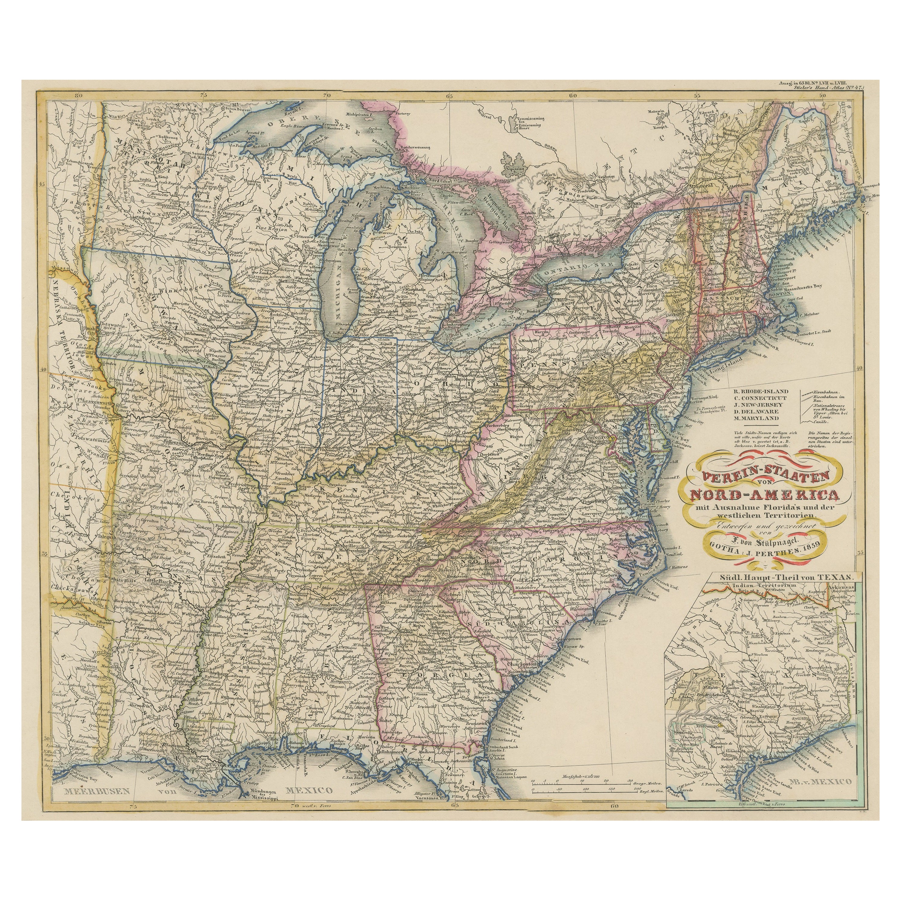
Antique Map of the Eastern United States with Inset Map of Texas
Located in Langweer, NL
Antique map titled 'Verein-Staaten von Nord-America mit Ausnahme Florida's und der Westlichen Territorien'. This map extends as far west as Louisiana and only includes the northern p...
Category
Antique Mid-19th Century Maps
Materials
Paper

$518 Sale Price
20% Off
Antique Map of The United States of North America, 1882
Located in Langweer, NL
This is a historical map titled "The United States of North America, Central Part" from the 1882 Blackie Atlas. It depicts the continental United States with a high level of detail, ...
Category
Antique 1880s Maps
Materials
Paper

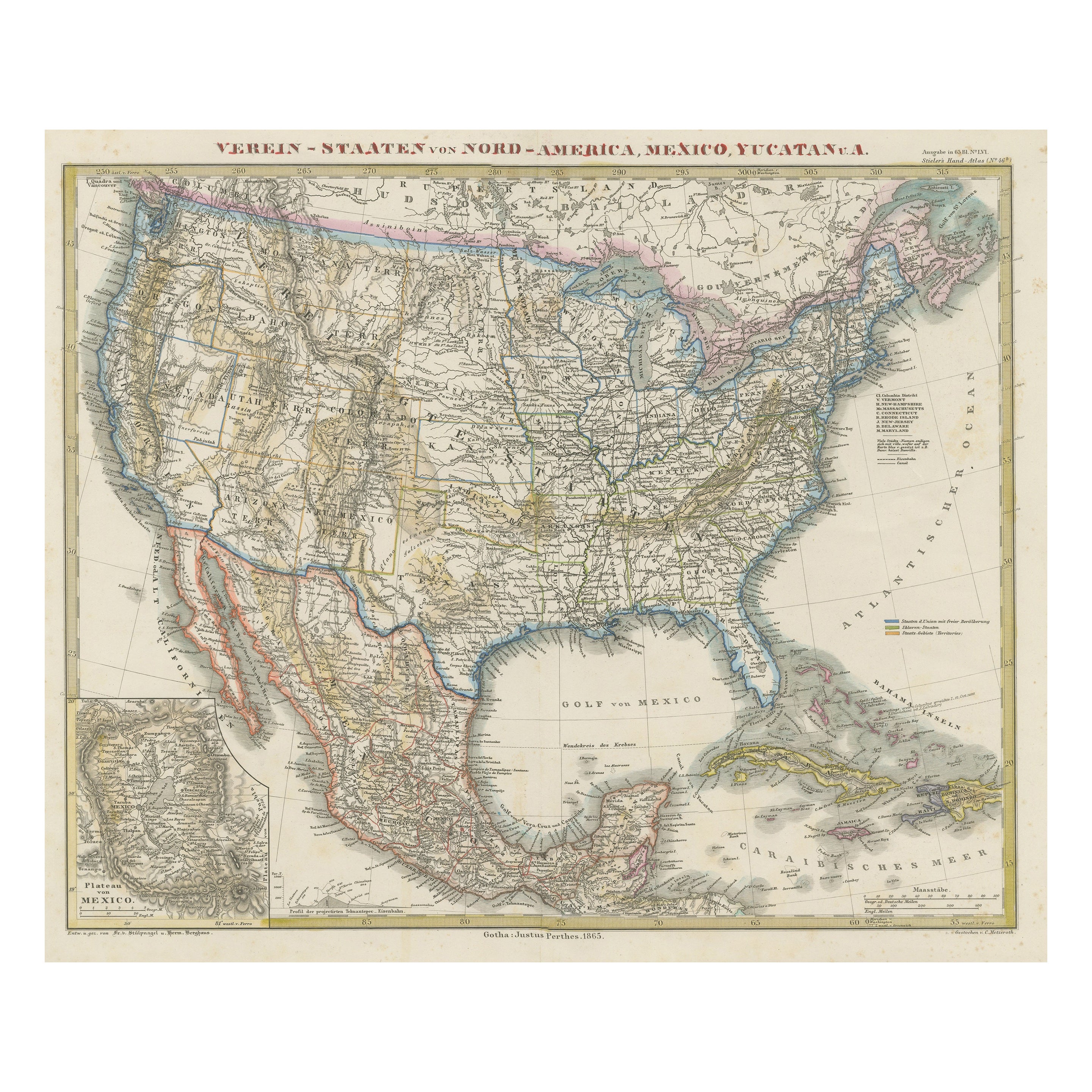
Antique Map of the United States of America, also showing the Caribbean
Located in Langweer, NL
Antique map titled 'Verein-Staaten von Nord-America, Mexico, Yucatan u.a.'. Very detailed map of the United States of America showing the ...
Category
Antique Mid-19th Century Maps
Materials
Paper

$787 Sale Price
20% Off
You May Also Like
Original Antique Map of United States, Grattan and Gilbert, 1843
Located in St Annes, Lancashire
Great map of United States
Drawn and engraved by Archer
Published by Grattan and Gilbert. 1843
Original colour
Unframed.
Category
Antique 1840s English Maps
Materials
Paper

Large Original Antique Map of the United States of America. 1891
By Rand McNally & Co.
Located in St Annes, Lancashire
Fabulous map of The United States
Original color
By Rand, McNally & Co.
Dated 1891
Unframed
Free shipping.
Category
Antique 1890s American Maps
Materials
Paper

Original Antique Map of The United States of America by Dower, circa 1835
Located in St Annes, Lancashire
Nice map of the USA
Drawn and engraved by J.Dower
Published by Orr & Smith. C.1835
Unframed.
Free shipping
Category
Antique 1830s English Maps
Materials
Paper

Large Original Vintage Map of North America, circa 1920
Located in St Annes, Lancashire
Great map of North America
Original color. Good condition
Published by Alexander Gross
Unframed.
Category
Vintage 1920s English Edwardian Maps
Materials
Paper

1859 "Map of the United States of America..." by J. H. Colton
By J.H. Colton
Located in Colorado Springs, CO
Presented is an 1859 “Map of the United States of America, the British Provinces, Mexico, the West Indies and Central America with Part of...
Category
Antique 1850s American Maps
Materials
Paper

1863 "Lloyd's New Map of the United States, the Canadas, and New Brunswick"
Located in Colorado Springs, CO
Presented is “Lloyd's New Map of the United States, the Canadas and New Brunswick, From the latest Surveys, Showing Every Railroad & Station Finished to June 1863, and the Atlantic and Gulf Coasts.” A large, Civil War-era hanging map of the United States and adjacent territories, this map covers the area from the Atlantic Ocean and extends as far west as the 103 meridian, to “Dacotah,” Nebraska, Kansas, "Indian Territory," and Texas. The southern continuation of Florida is shown in an inset map along the right margin. This map was published by J. T. Lloyd, in New York, in 1863. According to the publisher’s marking at lower right, this map was originally issued in two states: "in Sheets, Colored" for 50 cents, and "Varnished nicely, with Rollers" for $1.
Throughout the map, the counties are colored and the towns and cities well labeled. A reference key in the bottom margin provides symbols for railroads, turnpikes and wagon roads, state capitals, cities and towns, and village post offices. As emphasized in the map’s title, this map is especially notable for the countless railway lines and stations depicted, with distances noted between points, listing “every railroad and finished station to June 1863.” Additionally, two shipping agents and their routes are drawn out of New York City. The map includes details of the steamship routes into New York and Philadelphia from Liverpool and on to California and Oregon via an overland Nicaraguan trek, presumably to assist gold rush emigrants.
This expansive and impressive map depicts the eastern half of the United States in the third year of the Civil War. In order not to recognize the legitimacy of the Confederate States of America, each state is shown in the same manner as the Union states. The only indication that the American Civil War was in progress when this map was published is a printed notice that Gideon Wells, Secretary of the Navy, wishes to acquire a quote on 100 copies of Lloyd’s Mississippi River map...
Category
Antique 1860s American Maps
Materials
Linen, Wood, Paper

More Ways To Browse
Cambodia Antique Map
Charles Hutchinson
Coronelli Globe
Denoyer Geppert Anatomy
E Fletcher
Framed Africa Maps
Gabon Antique Map
Hudson River Map
Mauritius Antique Map
Nova Hollandia
Used Furniture Cleveland Ohio
Vintage Bartholomew Maps
1820 World Map
Aden Yemen
Antique Map New Orleans
Dakota Johnson
French School Map
Miliens S