Items Similar to Original Map of the East Indies Including Sumatra, Java, Borneo & Malaysia, 1755


Video Loading
Want more images or videos?
Request additional images or videos from the seller
1 of 12
Original Map of the East Indies Including Sumatra, Java, Borneo & Malaysia, 1755
$418.90
£309.01
€350
CA$580.41
A$630.22
CHF 333.74
MX$7,724.63
NOK 4,130.23
SEK 3,902.84
DKK 2,664.50
About the Item
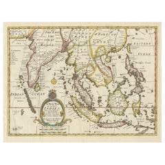
TitlEast Indies map – Java, Sumatra, Borneo & Malay Peninsula, c.1755
Attractive 18th-century map of the East Indies centered on Borneo and the Malay world, showing Sumatra, Java, the Malay Peninsula, Celebes (Sulawesi) and adjoining seas threaded with rhumb lines from a bold eight-point compass rose. Engraved by the noted Dutch draughtsman Jakob (J.) van der Schley for the Dutch edition of Antoine-François Prévost’s celebrated travel compendium, Histoire générale des voyages (Algemeene Geschiedenis der Reizen). The bilingual cartouche—French and Dutch—reflects the plate’s origin for a Dutch readership fascinated by VOC trade routes and the spice islands in the mid-18th century.
Coastal place-names are richly distributed: Malacca and the Straits, Bantam and Batavia on Java, the Sunda Strait, Banka and Billiton, Macassar, the Natuna and Anambas groups, Mindoro and the Calamianes at upper right, and part of New Guinea and the Moluccas to the east. Soundings, shoals, banks and anchorages pepper the seas, underlining the chart’s practical nautical flavor. An equatorial line bisects Borneo, and neat engraved borders with degree scales frame the image. Van der Schley—trained by Bernard Picart—brought a crisp, elegant line to the Dutch Prévost plates; here it’s complemented by fine contemporary hand color that differentiates islands and coastlines with pleasing clarity.
Beyond its decorative appeal, the sheet encapsulates the geography and commerce of the VOC sphere in the decades before Cook and Raffles, when Batavia was the hub of a far-reaching maritime empire. This is a strong, well-inked impression with the typical vertical fold from issue—ideal for collectors of Southeast Asia, VOC cartography, or the Prévost series.
Condition:
Good, with general age toning. Image slightly trimmed; minor handling wear and a few small spots. Original vertical fold as issued; blank verso. Visible platemark.
Framing tips:
A warm ivory or pale cream conservation mat will set off the hand color; a dark wood or ebonized frame lends gravitas, while a narrow gilt slip adds a period accent. Float-mounting to show the platemark is recommended.
Technique: Hand-colored copper engraving
Maker: Jakob van der Schley, Amsterdam, c.1755
- Dimensions:Height: 9.65 in (24.5 cm)Width: 13 in (33 cm)Depth: 0.01 in (0.2 mm)
- Materials and Techniques:Paper,Engraved
- Place of Origin:
- Period:1750-1759
- Date of Manufacture:1755
- Condition:Wear consistent with age and use. Good, with general age toning. Image slightly trimmed; minor handling wear and a few small spots. Original vertical fold as issued; blank verso. Visible platemark.
- Seller Location:Langweer, NL
- Reference Number:Seller: PCT-281 1stDibs: LU3054326777592
About the Seller
5.0
Recognized Seller
These prestigious sellers are industry leaders and represent the highest echelon for item quality and design.
Platinum Seller
Premium sellers with a 4.7+ rating and 24-hour response times
Established in 2009
1stDibs seller since 2017
2,623 sales on 1stDibs
Typical response time: <1 hour
- ShippingRetrieving quote...Shipping from: Langweer, Netherlands
- Return Policy
Authenticity Guarantee
In the unlikely event there’s an issue with an item’s authenticity, contact us within 1 year for a full refund. DetailsMoney-Back Guarantee
If your item is not as described, is damaged in transit, or does not arrive, contact us within 7 days for a full refund. Details24-Hour Cancellation
You have a 24-hour grace period in which to reconsider your purchase, with no questions asked.Vetted Professional Sellers
Our world-class sellers must adhere to strict standards for service and quality, maintaining the integrity of our listings.Price-Match Guarantee
If you find that a seller listed the same item for a lower price elsewhere, we’ll match it.Trusted Global Delivery
Our best-in-class carrier network provides specialized shipping options worldwide, including custom delivery.More From This Seller
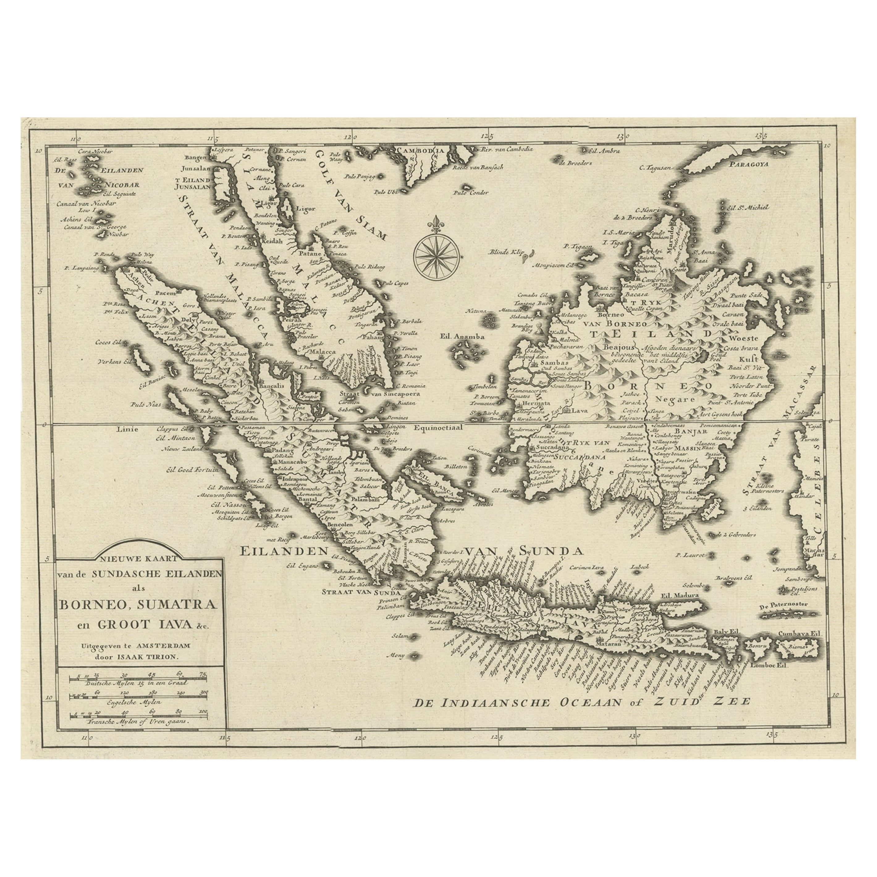
View AllAntique Map of the Sunda Islands Sumatra, Java, Malay Peninsula & Borneo (1739)
By Isaak Tirion
Located in Langweer, NL
Antique map titled 'Nieuwe kaart van de Sundasche Eilanden als Borneo, Sumatra en Groot Iava & c'. Detailed map of the Sunda Islands, Southeast Asia, extending from the tip of Cambod...
Category
Antique Mid-18th Century Maps
Materials
Paper

$700 Sale Price
21% Off
Original Antique Map of the Philippines, Malaysia, Indonesia, Singapore, c.1690
Located in Langweer, NL
Antique map titled 'Isole dell' Indie, diuise in Filippine, Molucche e della Sonda'.
Old map of the Philippines, Malaysia, Indonesia, Singapore, Northern Australia and contiguous i...
Category
Antique 1690s Maps
Materials
Paper

$2,154 Sale Price
20% Off
Free Shipping
Detailed Map of Southeast Asia From the Tip of Cambodia to Java, 1739
Located in Langweer, NL
Antique map titled 'Nieuwe kaart van de Sundasche Eilanden als Borneo, Sumatra en Groot Iava & c'.
Detailed map of Southeast Asia, extending from the tip of Cambodia to Java. Thi...
Category
Antique 1730s Maps
Materials
Paper
$619 Sale Price
24% Off
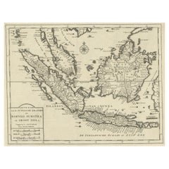
Antique Map of the Sunda Islands Including Sumatra, Java, and Borneo, 1705
Located in Langweer, NL
Title: “Antique Map of the Sunda Islands Including Sumatra, Java, and Borneo”
This print is a beautifully detailed and relatively rare map of Western Indonesia, encompassing the reg...
Category
Antique Early 1700s Maps
Materials
Paper

$823 Sale Price
20% Off
Free Shipping
Rare Antique Map of the Dutch East Indies 'Indonesia', 1774
Located in Langweer, NL
Rare decorative engraved map of the Dutch East Indies, or nowadays Indonesia.
Title (in old Dutch): NIEUWE EN NAUKEURIGE KAART DER OOST-INDISCHE ...
Category
Antique 1770s Maps
Materials
Paper

$1,148 Sale Price
20% Off
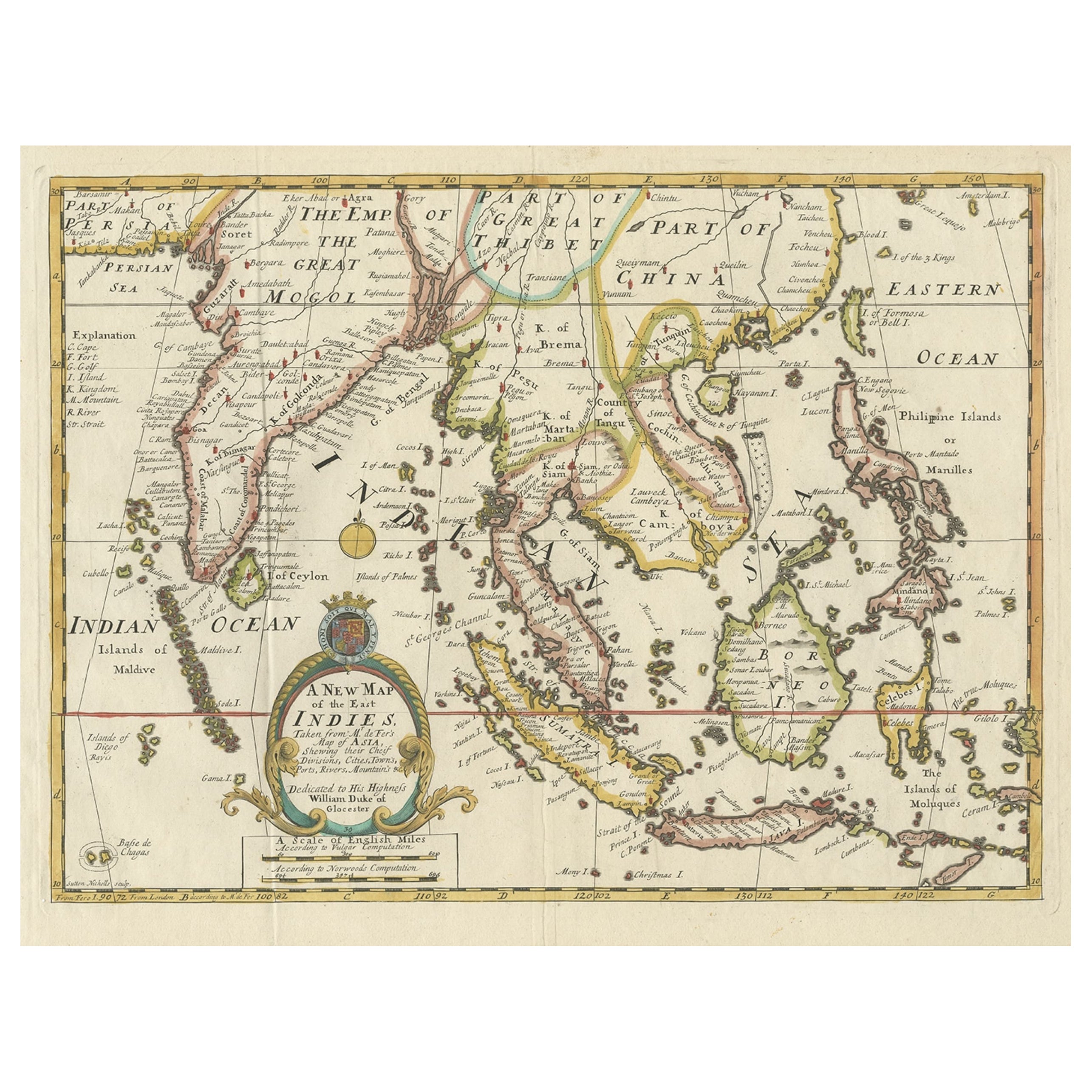
Old Map Covering All of Southeast Asia from Persia to the Timor Island, 1712
Located in Langweer, NL
Description: Antique map titled 'A New Map of the East Indies'. Old map covering all of Southeast Asia from Persia to the Timor Island, inclusive of the modern day nations of India, ...
Category
Antique 1710s Maps
Materials
Paper
$1,436 Sale Price
20% Off
You May Also Like
Antique 1803 Italian Map of Asia Including China Indoneseia India
Located in Amsterdam, Noord Holland
Antique 1803 Italian Map of Asia Including China Indoneseia India
Very nice map of Asia. 1803.
Additional information:
Type: Map
Country of Manufacturing: Europe
Period: 19th centu...
Category
Antique 19th Century European Maps
Materials
Paper

$584 Sale Price
20% Off
Antique French Map of Asia Including China Indoneseia India, 1783
Located in Amsterdam, Noord Holland
Very nice map of Asia. 1783 Dedie au Roy.
Additional information:
Country of Manufacturing: Europe
Period: 18th century Qing (1661 - 1912)
Condition: Overall Condition B (Good Used)...
Category
Antique 18th Century European Maps
Materials
Paper

$648 Sale Price
20% Off
Original Antique Map of South East Asia by Thomas Clerk, 1817
Located in St Annes, Lancashire
Great map of South East Asia
Copper-plate engraving
Drawn and engraved by Thomas Clerk, Edinburgh.
Published by Mackenzie And Dent, 1817
Unframed.
Category
Antique 1810s English Maps
Materials
Paper

Map of the East Indies: An Original 18th Century Hand-colored Map by E. Bowen
Located in Alamo, CA
This is an original 18th century hand-colored map entitled "An Accurate Map of the East Indies Exhibiting the Course of the European Trade both on the Continent and Islands" by Emanu...
Category
Mid-18th Century Old Masters Landscape Prints
Materials
Engraving

1627 Hendrik Hondius Map Entitled "Vltoniae Orientalis Pars, " Ric.a009
Located in Norton, MA
1627 Hendrik Hondius map entitled
"Vltoniae orientalis pars,"
Ric.a009
Title:
Vltoniae orientalis : pars
Title (alt.) :
Ultoniae orientalis pars
Creator:
Mercator, Gerh...
Category
Antique 17th Century Dutch Maps
Materials
Paper

Original Antique Map of South America. C.1780
Located in St Annes, Lancashire
Great map of South America
Copper-plate engraving
Published C.1780
Two small worm holes to left side of map
Unframed.
Category
Antique Early 1800s English Georgian Maps
Materials
Paper

More Ways To Browse
Malaysia Map
Antique Map By Coronelli
Cyprus Antique Maps
John Speed Maps
M Howard
Used Office Furniture Michigan
Antique Geological Maps
Antique Manitoba
Australian Colonial
Bengal Map
Stanford Furniture
Tennessee Antique Furniture
Used Furniture Alabama
Used Office Furniture Maine
Ancient World Map
Antique Florida Map
Antique Map Chile
Antique Map Of Georgia