Items Similar to Two Charts of The English Channel, Each Adorned with Nice Compass Roses, ca.1700
Want more images or videos?
Request additional images or videos from the seller
1 of 5
Two Charts of The English Channel, Each Adorned with Nice Compass Roses, ca.1700
$539.10
$673.8720% Off
£399.12
£498.9020% Off
€448
€56020% Off
CA$746.42
CA$933.0320% Off
A$814.91
A$1,018.6420% Off
CHF 427.23
CHF 534.0320% Off
MX$9,897.43
MX$12,371.7920% Off
NOK 5,335.35
NOK 6,669.1920% Off
SEK 5,037.99
SEK 6,297.4920% Off
DKK 3,410.72
DKK 4,263.4020% Off
About the Item
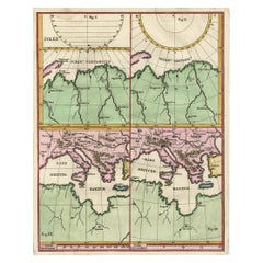
Antique map titled 'Hydrographia Canalis Marini Inter Angliam et Galiiam de Fluentis.'
Sheet with with two charts of the English Channel, each adorned with beautiful compass roses. The lower chart is inset with a tiny map of the region between Angers and Paris.
Source unknown, to be determined.
Artists and engravers: Made by 'Heinrich Scherer' after an anonymous artist. Heinrich Scherer (1628-1704) was a Professor of Hebrew, Mathematics and Ethics at the University of Dillingen until about 1680. Thereafter he obtained important positions as Official Tutor to the Royal Princes of Mantua and Bavaria. It was during his time in Munich as Tutor to the Princely house of Bavaria that his lifetime’s work as a cartographer received acclaim and recognition. Scherer’s world atlas, the Atlas Novus, first published in Munich between 1702 and 1710 and reissued in a second edition between 1730 and 1737, forms a singularly unusual, almost revolutionary work in terms of the development of European mapmaking at the beginning of the 18th century.
- Dimensions:Height: 10.63 in (27 cm)Width: 8.08 in (20.5 cm)Depth: 0 in (0.02 mm)
- Materials and Techniques:
- Period:1700-1709
- Date of Manufacture:circa 1700
- Condition:Condition: Good, given age. Irregular left edge from binding. General age-related toning and/or occasional minor defects from handling. Please study image carefully.
- Seller Location:Langweer, NL
- Reference Number:Seller: PCT-61424 1stDibs: LU3054326952732
About the Seller
5.0
Recognized Seller
These prestigious sellers are industry leaders and represent the highest echelon for item quality and design.
Platinum Seller
Premium sellers with a 4.7+ rating and 24-hour response times
Established in 2009
1stDibs seller since 2017
2,641 sales on 1stDibs
Typical response time: <1 hour
- ShippingRetrieving quote...Shipping from: Langweer, Netherlands
- Return Policy
Authenticity Guarantee
In the unlikely event there’s an issue with an item’s authenticity, contact us within 1 year for a full refund. DetailsMoney-Back Guarantee
If your item is not as described, is damaged in transit, or does not arrive, contact us within 7 days for a full refund. Details24-Hour Cancellation
You have a 24-hour grace period in which to reconsider your purchase, with no questions asked.Vetted Professional Sellers
Our world-class sellers must adhere to strict standards for service and quality, maintaining the integrity of our listings.Price-Match Guarantee
If you find that a seller listed the same item for a lower price elsewhere, we’ll match it.Trusted Global Delivery
Our best-in-class carrier network provides specialized shipping options worldwide, including custom delivery.More From This Seller
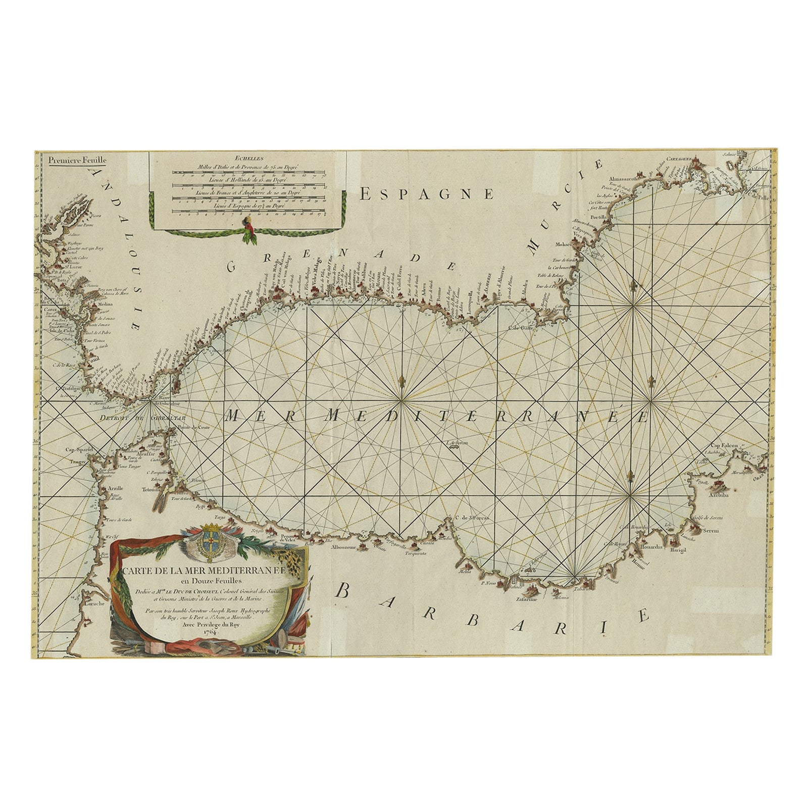
View AllLarge Decorative Antique Map of the Mediterranean, ca.1770
Located in Langweer, NL
Antique map titled 'Carte de la Mer Mediterranee en Douze Feuilles'.
First map out of twelve fine engraved double-page and folding maps that join to create a large wall map...
Category
Antique 1770s Maps
Materials
Paper
$1,097 Sale Price
20% Off
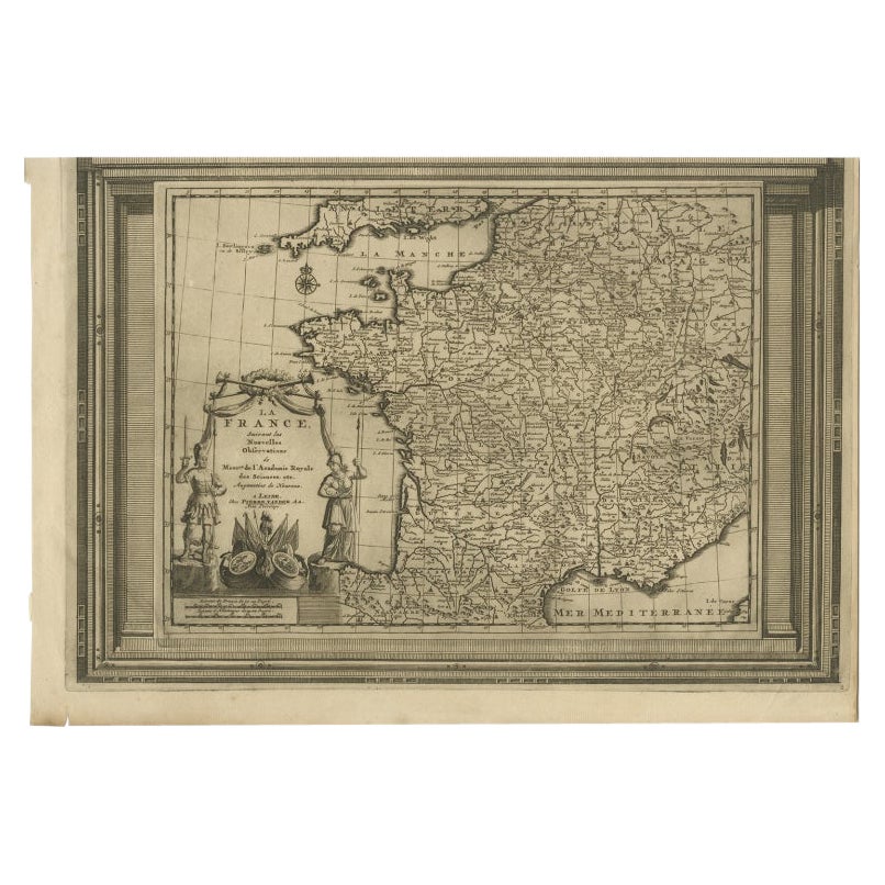
Antique Map of France with Beautiful Title Cartouche and Border, c.1740
Located in Langweer, NL
Antique map titled 'La France suivant les nouvelles Observations de Messrs de l'Academie Royale des Sciences etc.'. Rare map of France with beautiful title cartouche and decorative b...
Category
Antique 18th Century Maps
Materials
Paper
$433 Sale Price
20% Off
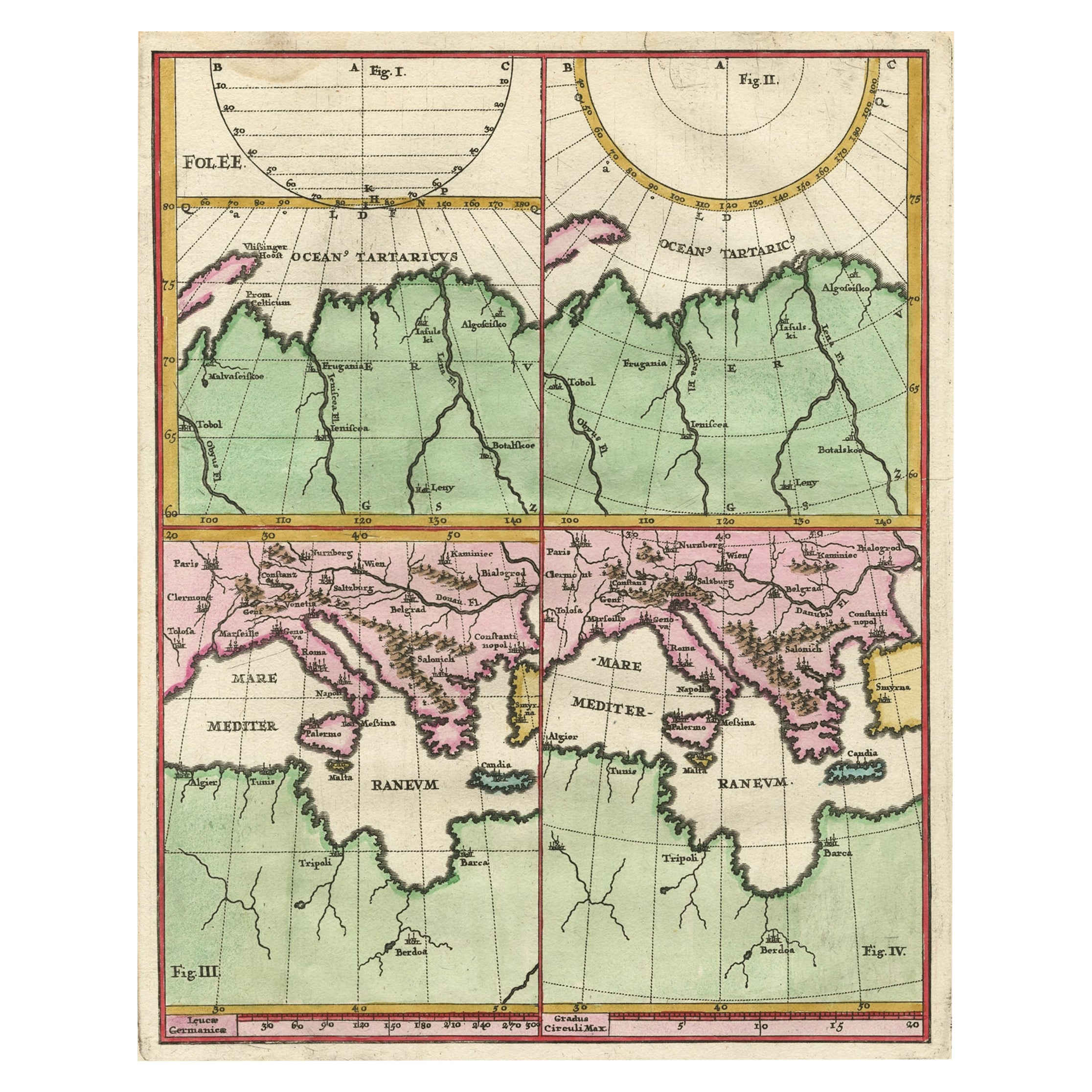
Curious Map of the Laptev Sea 'Arctic Ocean' and the Mediterranean, ca.1700
Located in Langweer, NL
Antique map, untitled.
Map of the Laptev Sea (Arctic Ocean) and the Mediterranean, printed for Scherer's 'Atlas Novus' (1702-1710). Scherer's 'Atlas Novus' forms an important mil...
Category
Antique Early 1700s Maps
Materials
Paper
$452 Sale Price
20% Off
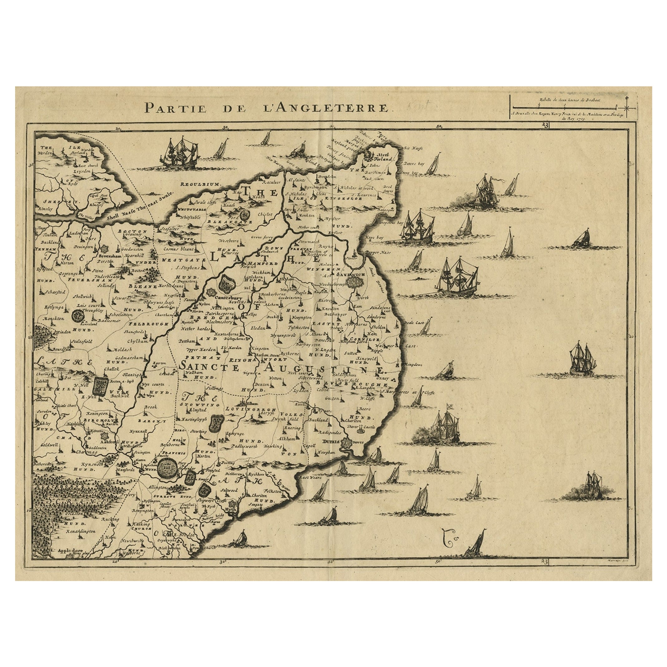
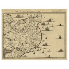
Uncommon Antique Map of the English Channel Coastline, ca.1709
Located in Langweer, NL
Antique map titled 'Partie de L'Angleterre' Uncommon map of the English Channel coastline with many boats on the sea. Source unknown, to be determined.
Artists and Engravers: Made...
Category
Antique Early 1700s Maps
Materials
Paper
$519 Sale Price
20% Off
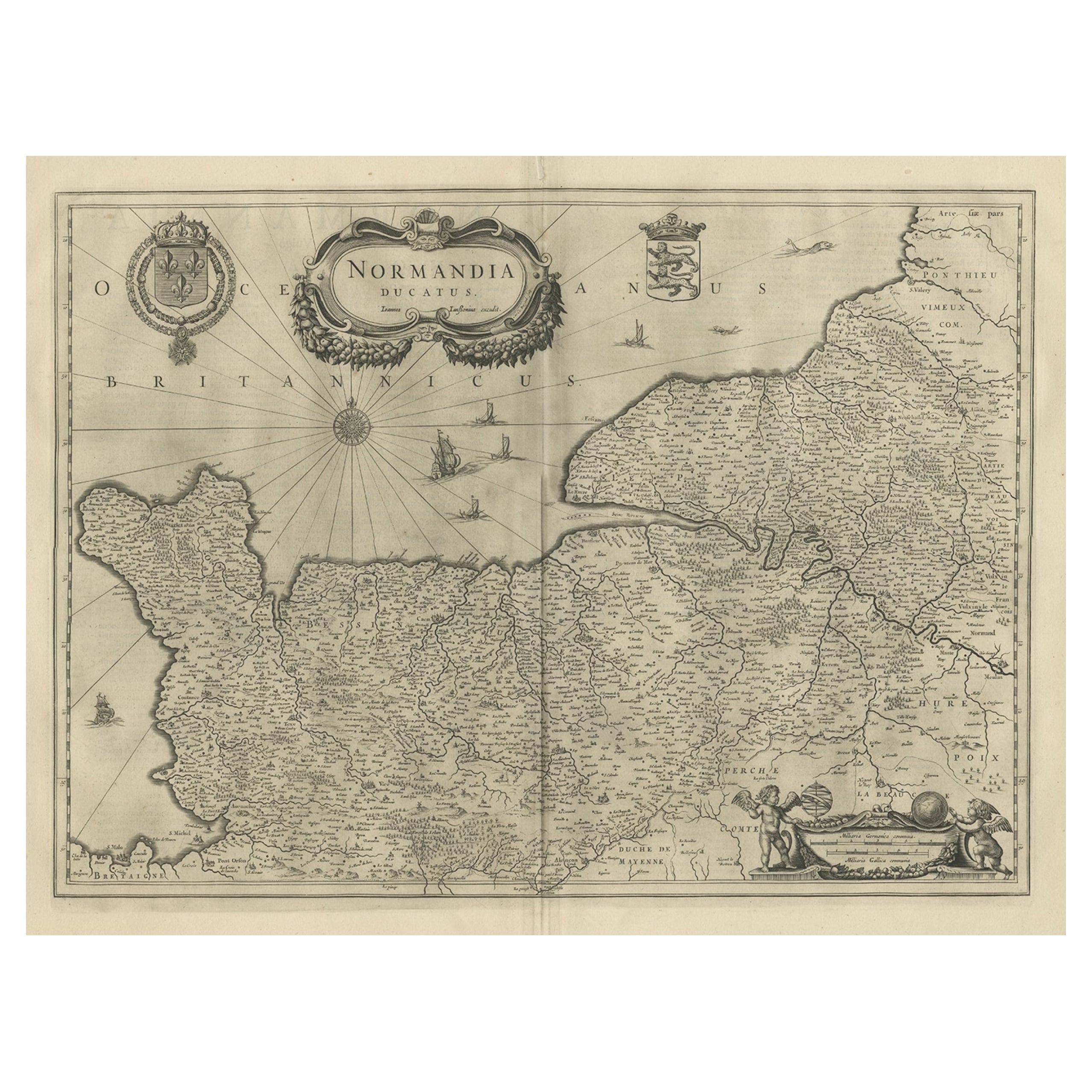
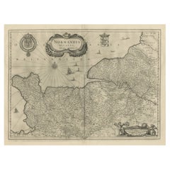
Antique Map of Normandy by Janssonius, 1657
Located in Langweer, NL
Antique map of France titled 'Normandia Ducatus'. Decorative map of the Normandy region, including decorative cartouche, sailing ships and compass rose. This map originates from 'Atl...
Category
Antique 17th Century Maps
Materials
Paper
$344 Sale Price
20% Off
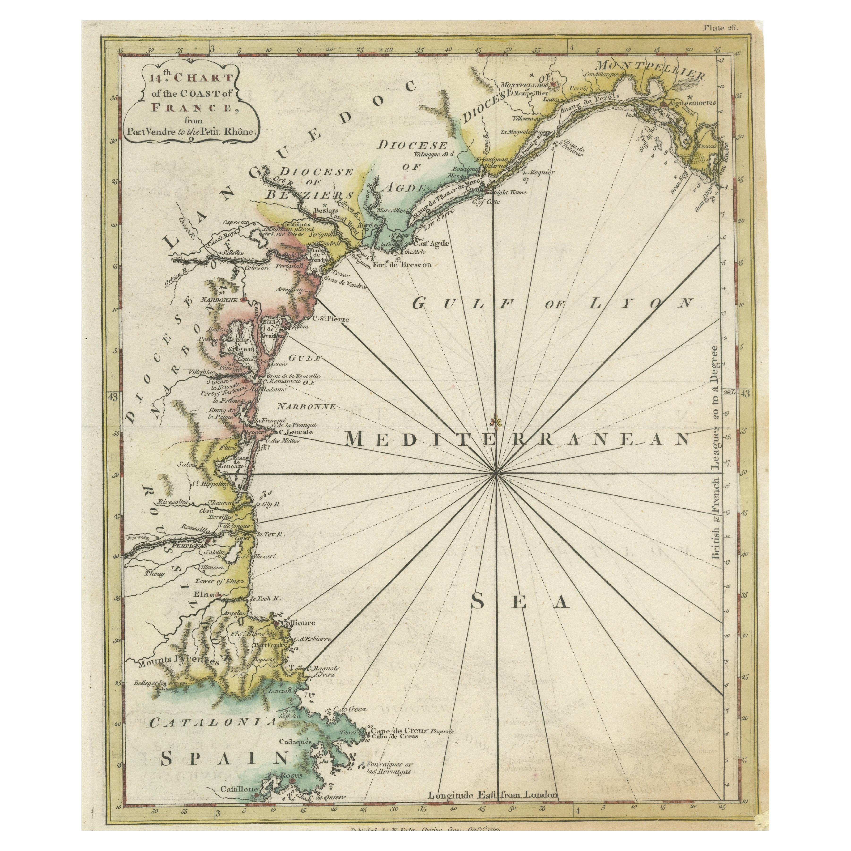
Antique Map of the Coast of Southern France, 1793
Located in Langweer, NL
Antique map titled '14th Chart of the Coast of France, from Port Vendres to the Petit Rhône'. Original map with later hand coroling of the coast of Southern France.
The "14th Chart of the Coast of France, from Port Vendres to the Petit Rhône" is an antique map that offers a detailed depiction of the southern coast of France, specifically highlighting the Mediterranean coastline. This map, which dates back to 1793, was originally part of "Le Petit Neptune Français; Or, French Coasting Pilot," a publication designed for maritime navigation along the French coastlines.
Key Features of the Map:
1. **Geographic Coverage**:
- The map covers the southern French coastline from Port Vendres in the west to the Petit Rhône in the east.
- It includes notable regions such as Languedoc, the Gulf of Lyon, and parts of Catalonia (Spain).
2. **Notable Places**:
- **Montpellier**: A major city in the Diocese of Montpellier, an important cultural and economic center.
- **Narbonne**: Located in the Diocese of Narbonne, a historical city with Roman heritage.
- **Agde**: Situated in the Diocese of Agde, known for its ancient Greek colony origins.
- **Béziers**: Part of the Diocese of Béziers, another city with deep historical roots dating back to Roman times.
- **Port Vendres**: A critical port near the Spanish border.
- **Catalonia**: Including parts of northeastern Spain, emphasizing the coastal connection between France and Spain.
3. **Dioceses and Regions**:
- The map is marked with various dioceses such as Montpellier, Agde, Narbonne, and Béziers, indicating ecclesiastical boundaries.
- It highlights the broader region of Languedoc, a historical province known for its wine production and medieval history.
4. **Navigational Aids**:
- The map features a compass rose with radiating lines, a common navigational aid in maritime maps...
Category
Antique Late 18th Century Maps
Materials
Paper

$231 Sale Price
20% Off
You May Also Like
17th Century Map of Denmark by French Cartographer Sanson, Dated 1658
By Nicolas Sanson
Located in Copenhagen, K
17th century map of Denmark by French cartographer Sanson.
Nicolas Sanson (20 December 1600-7 July 1667) was a French cartographer, termed by some the creator of French geography an...
Category
Antique 17th Century French Maps
Materials
Paper

18th Century Map of French Pyrenees Region of France
Located in Haddonfield, NJ
An antique map titled "Principatus Benearnia, La Principaute De Bearn" created by the renowned Dutch cartographer Willem Janszoon Blaeu.
It depicts the Principality of Bearn, a histo...
Category
Antique 1880s Danish Baroque Maps
Materials
Wood, Paper

1590 Mercator Map Entitled "France Picardie Champaigne, Ric.0001
Located in Norton, MA
Description: Published in Amsterdam by Mercator/Hondius ca. 1590.
Ric.0001
Artists and Engravers: Map : 'France Picardie Champaigne cum regionibus adiacentibus'. (Map of the french provinces of Picardie and Champagne.) Copper engraved map of the french provinces of Picardie and Champagne, showing the cities of Caen, Paris, Melun, Auxerre, Verdun, etc. Copperplate engraving on verge type hand laid paper with watermark. Description: Published in Amsterdam by Mercator/Hondius ca. 1600.Artists and Engravers: Mercator was born in Rupelmonde in Flanders and studied in Louvain under Gemma Frisius, Dutch writer, astronomer and mathematician. The excellence of his work brought him the patronage of Charles V, but in spite of his favor with the Emperor he was caught up in the persecution of Lutheran protestants and charged with heresy, fortunately without serious consequences. No doubt the fear of further persecution influenced his move in 1552 to Duisburg, where he continued the production of maps, globes and instruments. Mercator's sons and grandsons, were all cartographers and made their contributions in various ways to his atlas. Rumold, in particular, was responsible for the complete edition in 1595. The map plates...
Category
Antique 16th Century Dutch Maps
Materials
Paper

Framed 17th Century Map of Cumberland, England by John Speed, 1610
By John Speed
Located in Middleburg, VA
A fascinating and richly detailed antique map of Cumberland County in northwest England, drawn and published by the celebrated English cartographer John Spe...
Category
Antique Early 17th Century English British Colonial Maps
Materials
Copper, Gold Leaf

1590 Ortelius Map of Calais and Vermandois, France and Vicinity Ric.a014
Located in Norton, MA
1590 Ortelius map of
Calais and Vermandois, France and Vicinity
Ric.a014
Two rare regional Abraham Ortelius maps on a single folio sheet. Left map, entitled Caletensium, depic...
Category
Antique 16th Century Dutch Maps
Materials
Paper

1640 Joan Bleau Map Entitled"Diocecese de rheims et le pais de rethel, " Eic.a011
Located in Norton, MA
1640 Joan Bleau map entitled
"Diocecese de rheims et le pais de rethel,"
Ric.a011
OAN BLAEU
Diocecese de Rheims, et le pais de Rethel.
Handcolored engraving, c.1640.
...
Category
Antique 17th Century Dutch Maps
Materials
Paper

More Ways To Browse
Royal Prince
1700 Antique Furniture
Antique Florida Map
Antique Map Chile
Antique Map Of Georgia
Antique Mississippi Furniture
Burgundy Map
John Speed Antique Maps
Malabar Map
Malaysia Map
Map Of Syria
Taiwan Map
Antique Chicago Maps
Dutch Bible
New Jersey 19th Century
Thailand Map
Antique Coal Mining
Antique Dutch Bible