Collectibles and Curiosities on Sale

751
to
560
168
751
751
751
37
22
17
11
6
5
5
4
3
3
2
1
1
1
1
1
779
1,020
121
283
414
159
36
24
37
64
37
92
85
65
36
17
457
153
134
39
32
199
59
49
45
44
21
17
5
2
2
Sale Items
Period: 19th Century
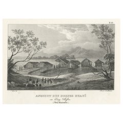
Original Lithograph with a Scene of a Village and Harbour in New Guinea, c.1836
Located in Langweer, NL
Antique print titled 'Ansicht des Dorfes Kuauï'. Im Dory Hafen. Old print with a scene of a village and harbour in New Guinea. This print originates from 'Entdeckungs, Reise der Franzosischen Corvette Astrolabe Unternomen auf Befehl Konig Karls...
Category

Antique 1830s Prints

Materials

Paper

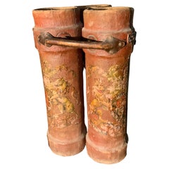
British Royal navy Cordite Charge Carrier rare 3 Cannister
Located in Surrey, BC
This is a rare example of the type of container that was used on Royal Navy ships to carry cordite charges. These were constructed of cork covered in canvas or leather. This one h...
Category

Antique Late 19th Century English Late Victorian Nautical Objects

Materials

Leather, Canvas, Cork

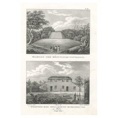
Residence of English missionaries in Hihifothe & Tomb of Tongamana, Tonga, 1836
Located in Langweer, NL
Antique print titled 'Grabmal des Häuptlings Tongamana' and 'Wohnung der Englischen Missionairs in Hifo'. Old print with two views, the upper image depicts the tomb of Tongamana. The lower image depicts a residence of an English missionary in Hihifo. This print originates from 'Entdeckungs, Reise der Franzosischen Corvette Astrolabe Unternomen auf Befehl Konig Karls...
Category

Antique 1830s Prints

Materials

Paper

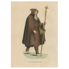
Print of a Monk of the Order of Poor Volunteers with Crucifix, 1845
Located in Langweer, NL
Antique print titled 'Pauvre Volontaire en Flandre'. Print of a Monk of the order of Poor Volunteers with crucifix and basket. This print originates from 'Histoire et Costumes de...
Category

Antique 1840s Prints

Materials

Paper

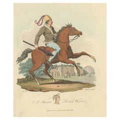
Old Hand-Colored Print of a Mounted British Warrior, 1815
Located in Langweer, NL
Antique print titled 'A Mounted British Warrior'. Old print of a British Warrior. Originates from 'Selections of the Ancient Costume of Great Brita...
Category

Antique 1810s Prints

Materials

Paper

Antique Chart of the Storm Centres of the United States, 1874
Located in Langweer, NL
Antique chart titled 'U.S. Signal Service chart showing the frequency of storm centres. Number of storm centres passing over each point deduced from the average of the two years Marc...
Category

Antique Late 19th Century Maps

Materials

Paper

Antique Print of The Sailing Race for the Admiral's Cup at Palma, 1881
Located in Langweer, NL
Antique print titled 'The Mediterranean Fleet Regatta at Palma'. This print depicts the race for the Admiral's Cup. Artists and Engravers: Published in The Illustrated London News...
Category

Antique 1880s Nautical Objects

Materials

Paper

Detailed Map of the Madura Strait, between Java & Madura Island, Indonesia, 1825
Located in Langweer, NL
Antique map titled 'Plan du Détroit de Madura'. Detailed map of the Madura Strait in Indonesia. The eastern part of the island Java with the city of Gresik and the western part o...
Category

Antique 1820s Maps

Materials

Paper

Old Costume Print Showing People at the Fair in Rotterdam, The Netherlands, 1817
Located in Langweer, NL
Antique costume print titled 'Group at the Fair at Rotterdam'. Old costume print depicting a group of people from Rotterdam. This print originates from 'The Costume of the Nether...
Category

Antique 1810s Prints

Materials

Paper

Engraving of a Chinese Garden in Canton and the Festival of Death in Macao, 1808
Located in Langweer, NL
Antique print titled 'Plan d'un Jardin Chinois à Quanton, Fête des Morts à Macao'. Two images on one sheet depicting a Chinese garden and Festival of the Death in Macao. Originat...
Category

Antique Early 1800s Maps

Materials

Paper

Antique Map of German Colonies by Meyer, 1895
Located in Langweer, NL
Antique map titled 'Deutsche Kolonien.' Lithographed map of the German Colonies. German East-Africa, German Southeast-Africa, Cameroon, Marshall-Islands, German Colonies in the Pacif...
Category

Antique 19th Century Maps

Materials

Paper

Old Print with a View of Saint Petersburg, Russia, 1887
Located in Langweer, NL
Description: Antique print titled 'Birds-Eye View of St. Petersburg'. Old print with a view of Saint Petersburg, Russia. Originates from 'Voyages and Travels'. Artists and En...
Category

Antique 1880s Maps

Materials

Paper

Antique American Coin Silver Presentation Birth Spoon, Fiddle Pattern
Located in Charleston, SC
Fine and rare antique American hand engraved coin silver presentation birth spoon, fiddle pattern, with maker's marks by silversmith: Eleazer Wyer, Jr. (...
Category

Antique Early 19th Century American Serving Pieces

Materials

Silver

Set of 2 Antique Maps of Scotland by W. G. Blackie, 1859
Located in Langweer, NL
Antique map titled 'Scotland'. Original antique map of Scotland. This map originates from ‘The Imperial Atlas of Modern Geography’. Published by W. G. Blackie, 1859.
Category

Antique Mid-19th Century Maps

Materials

Paper

Old Colourful View of the Tunnel Near Liverpool on the Manchester Railway, c1832
Located in Langweer, NL
Antique print titled 'Galeria subterranea'. Antique print of the inside of the tunnel built near Liverpool on the Liverpool and Manchester Railway. This print originates from 'Colo...
Category

Antique 1830s Prints

Materials

Paper

Antique Decorative Map of Portugal and Spain, 1842
Located in Langweer, NL
Antique map titled 'Carte de la Peninsule comprenant l'Espagne et le Portugal'. Map of Spain and Portugal. This map originates from 'Atlas universel de géographie ancienne et mod...
Category

Antique 1840s Maps

Materials

Paper

Antique Print of Three Whirlwinds and a Ship off the Coast of New Zealand, 1803
Located in Langweer, NL
Antique print titled 'Gezigt van Waterhoozen aan de Kust van Nieuw-Zeeland'. Antique print depicting three whirlwinds and a ship off the coast of New Zealand. Originates from 'Re...
Category

Antique Early 1800s Prints

Materials

Paper

Old Hand-Colored Print With a View of the Louvre, France, ca.1885
Located in Langweer, NL
Antique print titled 'Anischt des Louvre mit seinen Galerien, in Paris'. Old print with a view of the Louvre, France. This print originates from a German illustrated newsletter, pu...
Category

Antique 1880s Maps

Materials

Paper

Antique Map of Asia from a German School Atlas, c.1870
Located in Langweer, NL
Antique map titled 'Asien'. Old map of the Asian continent. This map originates from 'H. Kiepert's Kleiner Atlas der Neueren Geographie für Schule und Haus'. Artists and Engravers:...
Category

Antique 19th Century Maps

Materials

Paper

Rare Map of the Bay of St. Vladimir 'Russia' Showing the Route of J. Ward, 1869
Located in Langweer, NL
Antique map titled 'Côte est de Tartarie Baie St. Vladimir'. Map of the Bay of St. Vladimir (Russia) showing the route of J. Ward. Including a coastal view. Source unknown, to be...
Category

Antique 1860s Maps

Materials

Paper

Mahogany Chippendale Child's Chair Apprentice Sample, English, 19th Century
Located in San Francisco, CA
A miniature to scale mahogany Chippendale chair with needlepoint seat. Child size chair or possibly an apprentice or cabinet makers sample, England, ...
Category

Antique 19th Century English Chippendale Children's Furniture

Materials

Mahogany

Pair of Obelisks, Red Serpentine, Cornwall England 19th Century
Located in Greding, DE
Pair of small obelisks out of red serpentine with hieroglyph decor (North side Cleopatra's Needle, today Central Park, NY - and Lateranobelisk situated o...
Category

Antique 19th Century English Egyptian Revival Abstract Sculptures

Materials

Serpentine

Old Print of Entrance into Manchester Train Station across Water Street, ca.1832
Located in Langweer, NL
Antique print titled 'Entrada de Manchester por Water Street'. Antique print of the entrance into Manchester across Water Street. This print originates ...
Category

Antique 1830s Prints

Materials

Paper

Map of Winter Harbour on Melville Island, Australia by Parry's Expedition, 1821
Located in Langweer, NL
Antique print titled 'Survey of Winter Harbour Melville Island, June 1820'. Chart of the bay or harbor on Melville Island where William Parry's expedit...
Category

Antique 1820s Maps

Materials

Paper

Old Drawing or Plan of a Proa of Amsterdam Island, Now Tongatapu, Tonga, 1803
Located in Langweer, NL
Antique print titled 'Tekening, Plan en Doorsnede van eene dubbele Praauw (..)'. Antique print depicting a drawing, plan and cross-section of a proa of Amsterdam Island. Amsterda...
Category

Antique Early 1800s Prints

Materials

Paper

Rare 19th Century Large Original Painted Lightning Rod on Stand
Located in Los Angeles, CA
Fantastic folky oversized 19th century mustard over copper Lightning rod ball on a professional iron stand. The base is a plank of original work that the...
Category

Antique 19th Century American Folk Art Scientific Instruments

Materials

Copper

Antique Engraved Map of South East Australia from a German Atlas, 1848
Located in Langweer, NL
Antique map Australia titled 'Süd-Ost Australien'. Detailed map of South East Australia. Orginates from 'Stieler's Hand Atlas', published in Ge...
Category

Antique 19th Century Maps

Materials

Paper

Old Original Antique Map of Western Canada, 1882
Located in Langweer, NL
Antique map titled 'Dominion of Canada'. Old map of Western Canada. This map originates from 'The Royal Atlas of Modern Geography, Exhibiting, in a ...
Category

Antique 1880s Maps

Materials

Paper

Antique Map of Hennaarderadeel, Friesland, the Netherlands, 1868
Located in Langweer, NL
Antique map titled 'Provincie Friesland - Gemeente Hennaarderadeel'. Map of the township of Hennarderadeel including Oosterend, Wommels and many other villages. This map originates f...
Category

Antique 19th Century Maps

Materials

Paper

Old Print of the International Exhibition Building in Sydney, Australia, 1879
Located in Langweer, NL
Antique print titled 'The International Exhibition Building'. The Sydney International Exhibition opened in the autumn of 1879, but it wasn't really universal and therefore not off...
Category

Antique 1870s Prints

Materials

Paper

Old Map of Cook's Discovery and Charting of the East Coast of Australia, 1803
Located in Langweer, NL
Antique map titled 'Kaart van Nieuw Zuid Wales of de Oostlyke Kust van Nieuw Holland ontdekt en onderzogt door den Luitenant J. Cook met het Schip de Endeavour in het Jaar 1770'. ...
Category

Antique Early 1800s Maps

Materials

Paper

London Mid-19th Century Vanity Kit Set Sterling Silver
Located in Brescia, IT
Not easy to find this original box, with this kit set composed of 8 pieces for nail manicure. A piece to collect or to add in a wunderkammer. In sterling silver, all marked. With ce...
Category

Antique Mid-19th Century British Baroque Scientific Instruments

Materials

Crystal, Sterling Silver

Antique Map of Noord-Holland and the Island Texel in The Netherlands, c.1870
Located in Langweer, NL
Antique map titled 'De Provincie Noord-Holland'. Map of the province of Noord-Holland, the Netherlands. This map originates from 'F. C. Brugsma's Atlas van het Koninkrijk der Nederla...
Category

Antique 19th Century Maps

Materials

Paper

Original Copper Engraving of the Northeast Coast of Australia, 1803
Located in Langweer, NL
Antique map Australia titled 'Kaart van een gedeelte van de Kust van Nieuw Zuid Wales van Kwelling Kaap tot de Endeavour-Straat door Luit. J. Cook'. A chart of the northeast coast...
Category

Antique Early 1800s Maps

Materials

Paper

Astronomie Populaire, Description Générale Du Ciel by Camille Flammarion, '1880'
Located in Langweer, NL
'Astronomie populaire, description générale du ciel' by Camille Flammarion. Published in Paris, 1880. First edition of this pleasant work of scienti...
Category

Antique Late 19th Century Books

Materials

Paper

Antique Map of Central America Showing the Communication Lines, 1850
Located in Langweer, NL
Antique map titled 'Map of Central America Shewing the Different Lines of Atlantic & Pacific Communication'. A most unusual U.S. Government edition of this handsome map of Central Am...
Category

Antique 19th Century Maps

Materials

Paper

Antique Map of the Stars and Constellations by Lapie, 1842
Located in Langweer, NL
Antique map titled 'Planisheres Célestes'. Two hemispheres depicting the stars and constellations. This map originates from 'Atlas universel de géographie ancienne et moderne (..)' b...
Category

Antique Mid-19th Century Maps

Materials

Paper

Anitque Print of a Fire Station in Yokohama, Japan, 1856
Located in Langweer, NL
Description: Antique print titled ‘Fire Companys House & Engine Yokuhama‘. View of a fire station in Yokohama, Japan. This print originates from 'Narrat...
Category

Antique 1850s Prints

Materials

Paper

Large Italian Map of Islands of Oceania, incl Papua, Timor, Banda, Ceram, 1855
Located in Langweer, NL
Description: Antique map titled 'Carta di una parte dell'Oceania'. Beautiful large map of the (Spice) islands of Oceania. Depicting Papua, Timor, Ceram, Gilolo and many more. Source ...
Category

Antique 1850s Maps

Materials

Paper

Engraved Large Map of The Kingdom of Portugal Original Handcolored, 1854
Located in Langweer, NL
Antique map titled 'Mappa Corografica do Reino de Portugal - Chorographical map of the Kingdom of Portugal divided into its Grand Provinces.' Large map of...
Category

Antique 1850s Maps

Materials

Paper

Engraving of Allegorical Celebrations of the British Victories in America, 1880
Located in Langweer, NL
Antique print, untitled. Wonderful allegorical antique hand colored engraving depicting the celebrations of the British victories in America at the conclusion of the French & Indian ...
Category

Antique 1880s Maps

Materials

Paper

Antique Map of New Zealand by Scottish Geographer Johnston, 1882
Located in Langweer, NL
Antique map titled 'New Zealand'. Old map of New Zealand. This map originates from 'The Royal Atlas of Modern Geography, Exhibiting, in a Series of Entirely Original and Authentic ...
Category

Antique 19th Century Maps

Materials

Paper

Antique Print of 'Christ among the Doctors in the Temple' after Luini 'c.1890'
Located in Langweer, NL
Antique print titled 'Christ among the Doctors in the Temple'. Original antique print on chine collé, made after the painting by Luini. Source unknown, to be determined. Published ci...
Category

Antique Late 19th Century Prints

Materials

Paper

Antique Hand-Colored Print of a Greek Monk in Poland and a Slavonic Monk, c.1845
Located in Langweer, NL
Description: antique print titled 'Moine Grec en Pologne et Moine Esclavon'. Print of a Greek Monk. This print originates from 'Histoire et Costumes des...
Category

Antique 1840s Prints

Materials

Paper

Old Engraved Map of Hungary with Decorative Vignettes, 1851
Located in Langweer, NL
Antique map titled Hungary. Includes decorative vignettes titled Hungarian Peasants, Pesth and the Fortress of Buda, on the Danube and Hungarian Nobles. Originates from 'The Illustrated Atlas, And Modern History Of The World Geographical, Political, Commercial & Statistical, Edited By R. Montgomery Martin'. Published; John Tallis London, New York, Edinburgh & Dublin. 1851. Drawn and Engraved by J. Rapkin. Artists and Engravers: John Tallis (1817-1876) was a British map publisher. Born in the Midlands, Tallis came to London in the 1840s. Tallis began his London career with a series of remarkable London street views. He began a partnership with a Frederick Tallis, possibly his brother, but their collaboration ended in 1849. For the Great Exhibition of 1851, Tallis published the Illustrated World Atlas, one of the last series of decorative world maps ever produced. The maps were engraved by John Rapkin, a skilled artisan. The maps were later reissued by the London Printing & Publishing Company, who left the Tallis imprint intact, thus ensuring his enduring fame. In 1858, he began publication of the popular Illustrated News of the World...
Category

Antique 19th Century Maps

Materials

Paper

19th C Wonderful Spanish Shop Scale with Original Set of Weights
Located in Leuven , BE
There is a glass window on just one side so these would not have a counter between the customer and shop assistant, perhaps they were used to weigh tea, or coffee or chocolate.
Category

Antique 19th Century Spanish Historical Memorabilia

Materials

Metal

Original Antique Map of the United Kingdom and Ireland, Published in 1875
Located in Langweer, NL
Antique map titled 'Iles Britanniques ou Royaume-Uni de la Grande Bretagne (..)'. Large map of the United Kingdom and Ireland. This map originates from...
Category

Antique Late 19th Century Maps

Materials

Paper

Antique Map of Asia Depicting Asia and Australia, c.1814
Located in Langweer, NL
Antique map titled 'Asia'. This map depicts Asia and Australia. Engraved by J. and G. Menzies and issued for Thomson's 'New General Atlas'. Artists and Engravers: John Thomson (1...
Category

Antique 19th Century Maps

Materials

Paper

Antique Map of The World in Hemispheres by W. G. Blackie, 1859
Located in Langweer, NL
Antique map titled 'The World in Hemispheres with other projections'. Original antique map of The World. This map originates from ‘The Imperial Atlas of Modern Geography’. Published ...
Category

Antique Mid-19th Century Maps

Materials

Paper

All Round The World: An Illustrated Record of Voyages by Ainsworth, 1868
Located in Langweer, NL
All Round The World: An Illustrated Record of Voyages, Travels, and Adventure in All Parts of the Globe. First Series. With 200 illustrations and 6 finely engraved maps in full colou...
Category

Antique Mid-19th Century Books

Materials

Paper

German Antique Map of Australia and Polynesia, c.1870
Located in Langweer, NL
Antique map titled 'Inseln des Grossen Oceans, Australien und Polynesien'. Old map of Australia and Polynesia. This map originates from 'H. Kiepert's Kleiner Atlas der Neueren Geogra...
Category

Antique 19th Century Maps

Materials

Paper

Antique Map of the Twin Township of Ohio by Titus '1871'
Located in Langweer, NL
Antique map titled 'Twin'. Original antique map of Twin, Ohio. This map originates from 'Atlas of Preble County Ohio' by C.O. Titus. Published 1871.
Category

Antique Late 19th Century Maps

Materials

Paper

Antique Map of Bavaria in Southern Germany and Austria, 1806
Located in Langweer, NL
Antique map titled 'Cercles de Baviere et d'Autriche.' This map shows Bavaria in southern Germany and Austria. By Robert de Vaugondy, revised and published by Delamarche. Source unkn...
Category

Antique 19th Century Maps

Materials

Paper

Antique Map of Asia by Young, c.1860
Located in Langweer, NL
Antique map titled 'Asia'. Steel engraved map of Asia by Francis Young. Artists and Engravers: Engraved by Lewis Becker. Published by S.O. Beeton. We sell original antique maps to...
Category

Antique 19th Century Maps

Materials

Paper

Copper Alloy Weights Marc System
Located in Leuven , BE
Copper alloy weights Marc system.
Category

Antique 19th Century Scientific Instruments

Materials

Copper

Old Map Showing the Tracks of Cook Between North America and Asia's Coast, 1803
Located in Langweer, NL
Description: Antique map titled 'Kaart van de Noord-West kust van Amerika en de Noord-Oost kust van Asia'. Antique chart depicting America's northwest coast and Asia's northeast ...
Category

Antique Early 1800s Maps

Materials

Paper

Antique Map of Brazil, Including Part of Colombia, Peru and Chili, c.1880
Located in Langweer, NL
Antique map South America titled 'Brazil'. This map depicts Brazil and its surroundings including part of Colombia, Peru and Chili. Source un...
Category

Antique 19th Century Maps

Materials

Paper

Antique Chart of the Straits of Makassar, Indonesia with Borneo and Celebes-1820
Located in Langweer, NL
Description: Antique map titled 'A New Chart of the Straits of Macassar with various additions & improvements by J.W. Norie'. Rare and beautifully engraved chart of the Straits of Makassar showing Eastern Borneo and Celebes coast lines. With various smaller inset maps including a plan of the shoals off ragged and shoal points in Borneo, the Bay of Bonthain and the Straits of Salayr. Artists and Engravers: John William Norie (1772-1843), acquired the chart publishing business of William Heather after he died in 1812. He went into partnership with George Wilson...
Category

Antique 1820s Maps

Materials

Paper

Read More

Pamela Shamshiri Shares the Secrets behind Her First-Ever Book and Its Effortlessly Cool Interiors

The sought-after designer worked with the team at Hoffman Creative to produce a monograph that beautifully showcases some of Studio Shamshiri's most inspiring projects.

Moroccan Artworks and Objects Take Center Stage in an Extraordinary Villa in Tangier

Italian writer and collector Umberto Pasti opens the doors to his remarkable cave of wonders in North Africa.

Montecito Has Drawn Royalty and Celebrities, and These Homes Are Proof of Its Allure

Hollywood A-listers, ex-pat aristocrats and art collectors and style setters of all stripes appreciate the allure of the coastal California hamlet — much on our minds after recent winter floods.

Whaam! Blam! Pow! — a New Book on Pop Art Packs a Punch

Publishing house Assouline and writer Julie Belcove have teamed up to trace the history of the genre, from Roy Lichtenstein, Andy Warhol and Yayoi Kusama to Mickalene Thomas and Jeff Koons.

The Sparkling Legacy of Tiffany & Co. Explained, One Jewel at a Time

A gorgeous new book celebrates — and memorializes — the iconic jeweler’s rich heritage.

What Makes a Gem-Encrusted Chess Set Worth $4 Million?

The world’s most opulent chess set, weighing in at 513 carats, is literally fit for a king and queen.

Tauba Auerbach’s Geometric Pop-Up Book Is Mighty Rare, Thanks to a Hurricane

This sculptural art book has an epic backstory of its own.

Step inside the Storied Mansions of Palm Beach’s Most Effervescent Architect

From Spanish-style courtyards to fanciful fountains, these acclaimed structures abound in surprising and elegant details.
Recently Viewed

View All