
Morocco Map

1
to
14
139
126
160
120
70
37
33
32
28
26
25
18
16
11
9
8
7
7
7
7
7
6
5
4
3
3
3
3
2
2
2
2
2
2
2
1
1
1
1
1
1
1
1
1
1
42
42
6
4
4
Sort By
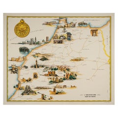
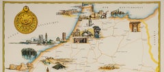
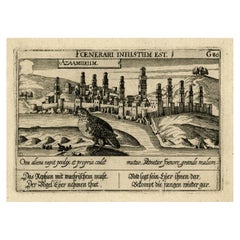
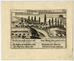
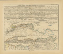
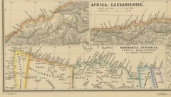
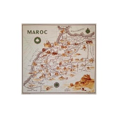
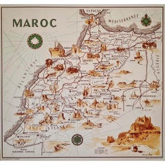
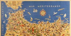
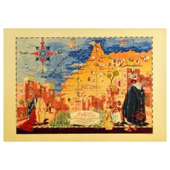
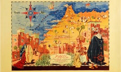
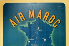
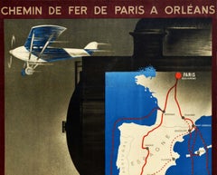
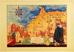
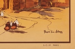
Delaye, Original Vintage Poster, South Morocco Map, Maghreb, Marrakech, 1930
Located in SAINT-OUEN-SUR-SEINE, FR
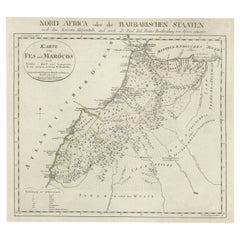
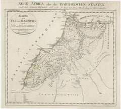
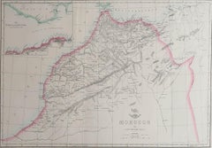
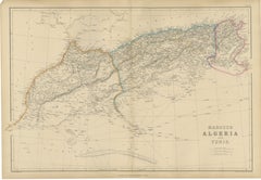
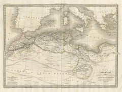
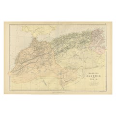
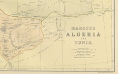
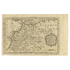
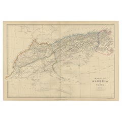
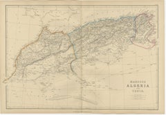
Original Vintage Poster for South Morocco Map dating from 1930 by Jean Theophile Delaye. Artist
Category

Vintage 1930s French Art Deco Posters

Materials

Paper

Original Antique Map of Fez and Morocco
Located in Langweer, NL
Antique map titled 'Karte von Fes und Marócos (..)'. Original old map of Fez (or Fes) and Morocco
Category

Antique Late 18th Century Maps

Materials

Paper

Original Antique Map of Fez and Morocco
H 13.31 in W 14.85 in D 0.02 in
Antique Map of the Empire of Morocco by Kitchin, c.1760
By Thomas Kitchin
Located in Langweer, NL
Antique map titled 'A Map of the Empire of Morocco Comprehending the Kingdoms of Fez, Morocco
Category

Antique 18th Century Maps

Materials

Paper

Vintage Red Boujad Moroccan Rug by Berber Tribes of Morocco
By Berber Tribes of Morocco
Located in Dallas, TX
21315 Vintage Red Boujad Moroccan Rug, 05'05 x 08'05. Boujad rugs, born from Morocco's Boujad
Category

Late 20th Century Moroccan Bohemian Moroccan and North African Rugs

Materials

Wool

Old Map of North Africa Depicting Libya, Morocco, Algeria, Tunis Etc, 1922
Located in Langweer, NL
, Morocco, Algeria, Tunis and surroundings. This map originates from 'The Times' atlas. Artists and
Category

Vintage 1920s Maps

Materials

Paper

Antique Map of Morocco Showing Towns of Marakesh, Taradant and Fez, 1636
Located in Langweer, NL
Antique map titled 'Fezzae et Marocchi regna Africae Celeberrima'. Map of Morocco, showing large
Category

Antique 17th Century Maps

Materials

Paper

Rare Map of North Africa Depicting Numidia, Libia and Morocco, Published C.1740
Located in Langweer, NL
Antique map Africa titled 'Mauretania, Numidia, Gaetulia & c.'. Rare map of North Africa
Category

Antique 1740s Maps

Materials

Paper

Old Map of the Kingdoms of Fez, Algiers, Segelmese, Tafilet and Morocco, ca.1760
Located in Langweer, NL
Antique map titled 'A Map of the Empire of Morocco Comprehending the Kingdoms of Fez, Morocco
Category

Antique 1760s Maps

Materials

Paper

Old Map of Morocco, The Canary Islands, Madeira, Inset of Penon de Velez, 1605
Located in Langweer, NL
Antique map titled 'Fessae et Marocchi Regna'. Original antique map of Morocco, extending south to
Category

Antique 17th Century Maps

Materials

Paper

Antique Decorative Coloured Map Marocco, Algeria and Tunis, 1882
Located in Langweer, NL
regions as understood in the late 19th century. **Map of Morocco, Algeria, and Tunis:** This map details
Category

Antique 1880s Maps

Materials

Paper

Antique Map of Northwest Africa by Bartholomew, 1922
Located in Langweer, NL
Antique map of Africa titled 'North-West Africa'. Old map of north-west Africa depicting Morocco
Category

20th Century Maps

Materials

Paper

Antique Map of North Africa by Ortelius, c.1600
Located in Langweer, NL
and the Mediterranean. The map extends from Morocco and the Sahara to Libya and shows most of the
Category

Antique 17th Century Maps

Materials

Paper

Antique Map of North Africa by Ortelius, c.1580
Located in Langweer, NL
Antique map titled 'Barbariae et Biledulgerid Nova Descriptio'. Original antique map of North
Category

Antique 16th Century Maps

Materials

Paper

Antique Map of the Basin of the Mediterranean by Johnston '1909'
Located in Langweer, NL
Mediterranean. With inset maps of the Strait of Gibraltar, Morocco, Maltese Islands, Valetta, Venice and
Category

Early 20th Century Maps

Materials

Paper

Antique Map of Tunis and Tripoli in Northern Africa, circa 1880
By J. Migeon
Located in Langweer, NL
Empire of Morocco. This map originates from 'Géographie Universelle Atlas-Migeon' by J. Migeon. Artists
Category

Antique 19th Century Maps

Materials

Paper

Antique Map of North Africa and South Africa by Black, 1854
Located in Langweer, NL
Morocco, Algeria and South Africa. This map orginates from 'General Atlas Of The World: Containing Upwards
Category

Antique 19th Century Maps

Materials

Paper

Antique Map of Western and Eastern Barbary in Africa, c.1744
Located in Langweer, NL
Antique map titled 'A New & Accurate Map of the Western Parts of Barbary' and 'A New & Accurate Map
Category

Antique 18th Century Maps

Materials

Paper

Antique Map of Northern Africa "Barbary Coast" by R. Bonne, circa 1780
Located in Langweer, NL
A fine example of Rigobert Bonne and Guilleme Raynal’s 1780 map of northwestern Africa or the
Category

Antique Late 18th Century Maps

Materials

Paper

West Africa Entitled "Guinea Propria": An 18th Century Hand Colored Homann Map
By Johann Baptist Homann
Located in Alamo, CA
This is a scarce richly hand colored copper plate engraved map of Africa entitled "Guinea Propria
Category

Antique Mid-18th Century German Maps

Materials

Paper

Antique Map of North-Western and South Africa by A.K. Johnston, 1865
Located in Langweer, NL
Two maps on one sheet titled 'North-Western Africa' and 'Southern Africa'. Depicting Morocco
Category

Antique Mid-19th Century Maps

Materials

Paper

Old Print of a Partridge in Front of The Walled City of Azemmour, Morocco, c1630
Located in Langweer, NL
partridge in the foreground, with the walled city (Azemmour in Morocco) behind. From: 'Thesauri Philo
Category

Antique 1630s Maps

Materials

Paper

North African Coasts: Marmarica to Mauretania in Roman Times, Published in 1880
Located in Langweer, NL
to parts of modern-day Libya, Tunisia, Algeria, and Morocco. Notable Features of the Map: 1
Category

Antique 1880s Maps

Materials

Paper

Crossroads of Continents: Spain's North African Enclaves in 1903
Located in Langweer, NL
The image for sale is a historical map of Spanish possessions in North Africa, dated 1903. The map
Category

Antique Early 1900s Maps

Materials

Paper

illustrated map of Morocco created in 1950 by Delaye
Located in PARIS, FR
Beautiful illustrated map of Morocco created in 1950 by Delaye. Main roads, car tracks, railroads
Category

1950s Prints and Multiples

Materials

Lithograph, Paper

Original Vintage Map Poster Marruecos Espanol Spanish Morocco Illustrated Design
Located in London, GB
Original vintage travel map poster for Marruecos Espanol / Spanish Morocco featuring a great
Category

Vintage 1940s Spanish Art Deco Posters

Materials

Paper

Choke II: Strait of Gibraltar (Spain & Morocco) - ceramic - map - black & white
By Gregor Turk
Located in Atlanta, GA
This ceramic wall sculpture features a topographic map in black and white. As a self-proclaimed
Category

2010s Abstract Sculptures

Materials

Ceramic

Original Vintage Air Maroc Travel Poster Route Map France Morocco Spain Services
By E. Esperance
Located in London, GB
jet plane flying towards the viewer with propellers on each wing and a route map in the background of
Category

Vintage 1950s French Posters

Materials

Paper

Les Arts Traditionnels au Maroc by Dr. M. Sijelmassi, Hardcover Book in French
By Berber Tribes of Morocco
Located in North Hollywood, CA
, and other examples of traditional Moroccan arts, 41 maps. Cloth cover Title: LES ARTS TRADITIONNELS AU
Category

Late 20th Century Moroccan Arts and Crafts Books

Materials

Paper

West Africa: 18th Century Hand-colored Homann Map Entitled "Guinea Propria"
By Johann Baptist Homann
Located in Alamo, CA
This is a scarce richly hand colored copper plate engraved map of Africa entitled "Guinea Propria
Category

1740s Other Art Style Prints and Multiples

Materials

Engraving

Moroccan Carpets: Pickering, Pickering, Yohe - Laurence King Hali Publications
Located in Rochester, NY
illustrations and 5 maps. A survey of 19th and 20th century Moroccan rugs and textiles featuring a collection of
Category

1990s Books

Materials

Paper

Mediterranean and Adriatic Seas: Original 18th Century Hand-colored Map by Bowen
Located in Alamo, CA
This is an original 18th century hand-colored map entitled "An Accurate Chart of The Mediterranean
Category

Mid-18th Century Old Masters Landscape Prints

Materials

Engraving

Tangiaria (Tanger), Map from "Civitates Orbis Terrarum"-by F. Hogenberg - 1575
By Franz Hogenberg
Located in Roma, IT
city, under the Portuguese domination until 1580, and the commercial role of the Moroccan port. Good
Category

16th Century Figurative Prints

Materials

Etching, Aquatint

1925 H. R. H. The Prince of Wales's Sport in India
Located in Bath, GB
expedition to India. The first edition of the work. Sumptuously rebound in half morocco. Endpapers and
Category

Vintage 1920s European Books

Materials

Paper

1923-27 Eight Volumes of Limited Edition Works by Daniel Defoe
By Daniel Defoe
Located in Bath, GB
works about the popular character Robinson Crusoe, bound in crushed half morocco. Limited edition
Category

Antique 1820s British Books

Materials

Paper

1929 The Novels of Captain Marryat
By Frederick Marryat
Located in Bath, GB
A superb set of the novels of Captain Marryat, elegantly and uniformly bound in half morocco, and
Category

Vintage 1920s British Books

Materials

Paper

1929 The Novels of Captain Marryat
H 8 in W 30 in D 5.5 in
Winston CHURCHILL. The World Crisis - 6 vols. - ALL FIRST EDITIONS 1923-1931
Located in Hillsborough, NJ
vols., 9-1/8" x 6-1/4", illustrated with maps (some fold-out) and charts, bound in 1/2 blue morocco
Category

Vintage 1920s British Books

Materials

Leather

All Round The World: An Illustrated Record of Voyages by Ainsworth, 1868
Located in Langweer, NL
colour map of Russia has a small tear on the fold. Original brown full morocco leather bindings, deep
Category

Antique Mid-19th Century Books

Materials

Paper

MARTIN GILBERT. The Life of Winston Churchill - 8 vols ALL 1st EDITIONS 1966-88
Located in Hillsborough, NJ
frontispiece to volume VIII, illustrated with numerous maps, half-tone illustrations, and fold-out plates
Category

Vintage 1960s British Books

Materials

Leather

MARTIN GILBERT. The Life of Winston Churchill - 8 vols. 1966-88 ALL 1st EDITIONS
Located in Hillsborough, NJ
frontispiece to volume VIII, illustrated with numerous maps, half-tone illustrations, and fold-out plates
Category

Vintage 1960s British Books

Materials

Leather

Rhodes, James Ford, History of the United States, 7 Vols, in a Fine Binding
Located in Hillsborough, NJ
. DESCRIPTION: 7 vols, 8-11/16" x 6-1/4", illustrated with fold-out maps, bound in 1/2 brown morocco, ribbed
Category

Vintage 1910s American Books

Materials

Leather

Original Imray & Son Chart of North Atlantic, 1876
Located in Norwell, MA
Scotia), Europe (England, Ireland, Norway, Denmark, France and Spain), African coast (including Morocco
Category

Antique 1870s Nautical Objects

Materials

Paper

Il Gazzettiere Americano - Ancient Illustrated Book on the Americas - 1763
Located in Roma, IT
3 volumes. Engraved title vignettes, 78 engraved plates and maps by Giuseppe Pazzi (including
Category

1760s More Art

Materials

Paper, Etching

Winston CHURCHILL. Marlborough His Life and Times - ALL 1ST EDITIONS - 4 VOLS
Located in Hillsborough, NJ
portrait frontispieces, numerous plates, facsimiles, maps and plans, bound in fine full dark blue morocco
Category

Vintage 1930s British Books

Materials

Leather

T. E. LAWRENCE - Seven Pillars Of Wisdom - 1935 - FIRST TRADE EDITION
Located in Hillsborough, NJ
photogravure portrait frontispiece of Lawrence from the plaster bust, 47 plates, 4 folding maps, and several in
Category

Vintage 1930s British Books

Materials

Leather

TOLKIEN. The Hobbit. 1937 - 1st ED 2nd IMPRESSION - THE FIRST WITH COLOR PLATES!
Located in Hillsborough, NJ
end, bound in full dark green morocco, ribbed gilt decorated spine, covers ruled in gilt, Smaug the
Category

Vintage 1930s British Books

Materials

Leather

Personal Memoirs of U. S. Grant, Two-Volume Set, 1885-86
Located in Colorado Springs, CO
dated May 23, 1885 exactly two months before Grant passed away. Forty-three maps, wood engravings, and
Category

Antique 1880s American Books

Materials

Leather, Paper

Memoirs of General William T. Sherman, First Edition, Two-Volume Set, 1875
Located in Colorado Springs, CO
cloth, full sheepskin, and half blue moroccan leath. Sherman explains his motivations for writing in
Category

Antique 1870s American Books

Materials

Leather, Paper

Keating, William. Narrative of an Expedition to the Source of St. Peter's River
Located in Middletown, NY
black morocco label spine; hinges and edges rubbed; front hinge of Volume 1 cracked internally; t .e. g
Category

Antique Early 19th Century English Books

Materials

Leather, Paper

"Engravings by Rex Whistler for Jonathan Swift's Gulliver's Travels"
Located in Bristol, CT
containing 31 leaves in total and an original printing plate. Clamshell case bound in 3/4 green Morocco cream
Category

1970s More Art

Materials

Paper

Picturesque Tour of the Seine, from Paris to the Sea / Ackermann, First Edition
Located in Middletown, NY
), pp. x, 177, title vignette and 24 hand colored aquatints, map. Later three-quarter yellow levant
Category

Antique Early 19th Century English Books

Materials

Leather, Paper

Original Graham Gallery poster (hand signed by Nancy Graves)
By Nancy Graves
Located in New York, NY
, she would live a somewhat nomadic life, spending time in countries that included Morocco, Kashmir
Category

1960s Post-Minimalist Animal Prints

Materials

Lithograph, Pencil, Offset

Guide to The Victoria and Albert Museum, 1910
Located in valatie, NY
Guide to The Victoria and Albert Museum. London: His Majesty's Stationery Office, 1910. Moroccan
Category

Early 20th Century English Books

Materials

Paper

Little America by Richard E. Byrd, First Edition, 1930
Located in Colorado Springs, CO
. New York: G.P. Putnam's Sons, 1930. First edition. Octavo. Presented in quarter royal blue Moroccan
Category

Vintage 1930s American Books

Materials

Leather, Paper

Bibliomania or Book Madness by Thomas Frognall Dibdin, 1842
Located in Dallas, TX
extremely GOOD. The text is almost perfect. Red Moroccan Leather and wavy board jacket with gilt edge and
Category

Antique Mid-19th Century English Early Victorian Books

Materials

Paper

Giant Egg of the Extinct 'Elephant Bird'
Located in London, GB
talons. This bird was known as the roc, or rukh. A similar story was later told by the Moroccan explorer
Category

Antique 15th Century and Earlier Malagasy Natural Specimens

Materials

Eggshell

Giant Egg of the Extinct 'Elephant Bird'
Free Shipping
H 11.23 in Dm 7.76 in
Large Nancy Graves Color Aquatint Drypoint Etching Screenprint Metallic Gold
By Nancy Graves
Located in Surfside, FL
, and sometime-filmmaker known for her focus on natural phenomena like camels or maps of the moon. Her
Category

1980s Contemporary Abstract Prints

Materials

Screen

Japanese Children with Tortoise
By Harry Humphrey Moore
Located in New York, NY
, and California. This globe-trotting painter was also active in Morocco, and most importantly, he was
Category

Late 19th Century Figurative Paintings

Materials

Oil, Wood Panel

Interior of a Japanese House
By Harry Humphrey Moore
Located in New York, NY
, and California. This globe-trotting painter was also active in Morocco, and most importantly, he was
Category

Late 19th Century Interior Paintings

Materials

Oil, Wood Panel

Le Nid (The Nest)
By Jean Pierre Serrier
Located in San Francisco, CA
avoided Indochina but left for Morocco then Algeria.When they discovered his training, he became
Category

Mid-20th Century Surrealist Figurative Paintings

Materials

Oil

Suzanne Benton, Male Grace, 2017, Monoprint
By Suzanne Benton
Located in Darien, CT
this new territory she provides a map that others may follow. Proust’s novel recreates the huge
Category

2010s Symbolist Portrait Prints

Materials

Monoprint

  • 1
Get Updated with New Arrivals
Save "Morocco Map", and we’ll notify you when there are new listings in this category.

Morocco Map For Sale on 1stDibs

Find the exact morocco map you’re shopping for in the variety available on 1stDibs. There are many Art Deco, Abstract and Old Masters versions of these works for sale. You’re likely to find the perfect morocco map among the distinctive items we have available, which includes versions made as long ago as the 18th Century as well as those made as recently as the 21st Century. When looking for the right morocco map for your space, you can search on 1stDibs by color — popular works were created in bold and neutral palettes with elements of beige, blue, brown and orange. Creating a morocco map has been a part of the legacy of many artists, but those crafted by Robert Falcucci, Gerard Mercator and Gregor Turk are consistently popular. Frequently made by artists working in paper, ceramic and engraving, these artworks are unique and have attracted attention over the years.

How Much is a Morocco Map?

The price for a morocco map in our collection starts at $288 and tops out at $5,693 with the average selling for $3,389.