Items Similar to Silver Leaf Foil Wall World Map Engraving Based on the Original Moses Pitt, 1681


Want more images or videos?
Request additional images or videos from the seller
1 of 14
Silver Leaf Foil Wall World Map Engraving Based on the Original Moses Pitt, 1681
$264.17
$377.3930% Off
£192.50
£27530% Off
€226.34
€323.3430% Off
CA$364.75
CA$521.0730% Off
A$404.48
A$577.8230% Off
CHF 212.52
CHF 303.6030% Off
MX$4,942.01
MX$7,060.0230% Off
NOK 2,658.94
NOK 3,798.4930% Off
SEK 2,495.87
SEK 3,565.5330% Off
DKK 1,689.67
DKK 2,413.8130% Off
About the Item
We are delighted to offer for sale this lovely antique style pictorial silver leaf foil world map taken from and original engraving my Moses Pitt, 1681
This is a very interesting and decorative piece, it looks good in any setting. It is an etching some was made by some kind of printing method
Condition wise the frame will have age related patina marks here and there, it is 40-50 years old
Dimensions:
Height:- 45cm
Width:- 55cm
Depth:- 1.5cm
Please note all measurements are taken at the widest point.
This item is available for collection from our Wimbledon warehouses.
Condition:
Please view the very detailed pictures as they form part of the description around condition
Please note vintage period and original items such as leather seating will always have natural patina in the form of cracking creasing and wear, we recommend regular waxing to ensure no moisture is lost, also hand dyed leather is not recommended to sit in direct sunlight for prolonged periods of time as it will dry out and fade.
- Dimensions:Height: 17.72 in (45 cm)Width: 21.66 in (55 cm)Depth: 0.6 in (1.5 cm)
- Style:Modern (Of the Period)
- Materials and Techniques:
- Place of Origin:
- Period:
- Date of Manufacture:20th Century
- Condition:Wear consistent with age and use. Minor fading.
- Seller Location:West Sussex, GB
- Reference Number:1stDibs: LU2823320334282
About the Seller
4.7
Platinum Seller
Premium sellers with a 4.7+ rating and 24-hour response times
Established in 2012
1stDibs seller since 2017
2,017 sales on 1stDibs
Typical response time: <1 hour
- ShippingRetrieving quote...Shipping from: West Sussex, United Kingdom
- Return Policy
Authenticity Guarantee
In the unlikely event there’s an issue with an item’s authenticity, contact us within 1 year for a full refund. DetailsMoney-Back Guarantee
If your item is not as described, is damaged in transit, or does not arrive, contact us within 7 days for a full refund. Details24-Hour Cancellation
You have a 24-hour grace period in which to reconsider your purchase, with no questions asked.Vetted Professional Sellers
Our world-class sellers must adhere to strict standards for service and quality, maintaining the integrity of our listings.Price-Match Guarantee
If you find that a seller listed the same item for a lower price elsewhere, we’ll match it.Trusted Global Delivery
Our best-in-class carrier network provides specialized shipping options worldwide, including custom delivery.More From This Seller
View AllVintage World Map Mirror Based on the Original by Johnson 1882 Military Campaign
Located in West Sussex, Pulborough
We are delighted to offer for sale this lovely Antique style pictorial plan map of the globe based on the original by Johnson in 1882
This is a very interesting and decorative pie...
Category
20th Century English Campaign Maps
Materials
Mirror

$288 Sale Price
30% Off
Gold Leaf Foil Pictorial Plan Map of the West Country of England Antique Style
Located in West Sussex, Pulborough
We are delighted to offer for sale this lovely Antique style pictorial plan map of the West Country of England etched in gold leaf foil
This is a very interesting and decorative p...
Category
20th Century English Adam Style Maps
Materials
Gold Leaf

$264 Sale Price
30% Off
London 1744 Published Watercolour Antique Map of East Africa by Eman Bowen
Located in West Sussex, Pulborough
We are delighted to offer for sale this New and Accurate Map of Nubia & Abissinia, together with all the Kingdoms Tributary Thereto, and bordering upon them published in 1744 by Emanuel Bowen
This is a decorative antique engraved map of East Africa...
Category
Antique 1740s English George III Maps
Materials
Paper

$912 Sale Price
30% Off
Greece 1660 Jan Jansson Watercolour Map Peloponesus Sive Morea I Laurenbergio
Located in West Sussex, Pulborough
We are delighted to offer for sale this Jan Jansson Date: 1660 (published) Amsterdam map of Greece.
This is an authentic antique map of Peloponnese or...
Category
Antique 1660s Danish Dutch Colonial Maps
Materials
Copper

$720 Sale Price
30% Off
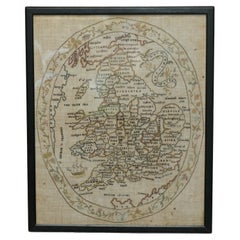
Antique Elizabeth Mason Signed 1789 George II Needlework Sampler Map of England
Located in West Sussex, Pulborough
We are delighted to offer for sale this rather stunning, 1789 dated needlework sampler signed by Elizabeth Mason and dated 1789
I have three other versions of these samplers for ...
Category
Antique 1780s English George II Tapestries
Materials
Cotton
$3,128 Sale Price
20% Off
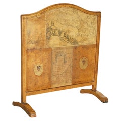
ANTIQUE EDWARDIAN LEATHER CLAD & EMBOSSED FiRE SCREEN WITH MAP DECORATION
Located in West Sussex, Pulborough
Royal House Antiques
Royal House Antiques is delighted to offer for sale this lovely Edwardian circa 1900 Leather clad and embossed fire screen
Please note the delivery fee listed ...
Category
Antique Early 1900s European Edwardian Screens and Room Dividers
Materials
Leather, Pine
$1,296 Sale Price
30% Off
You May Also Like
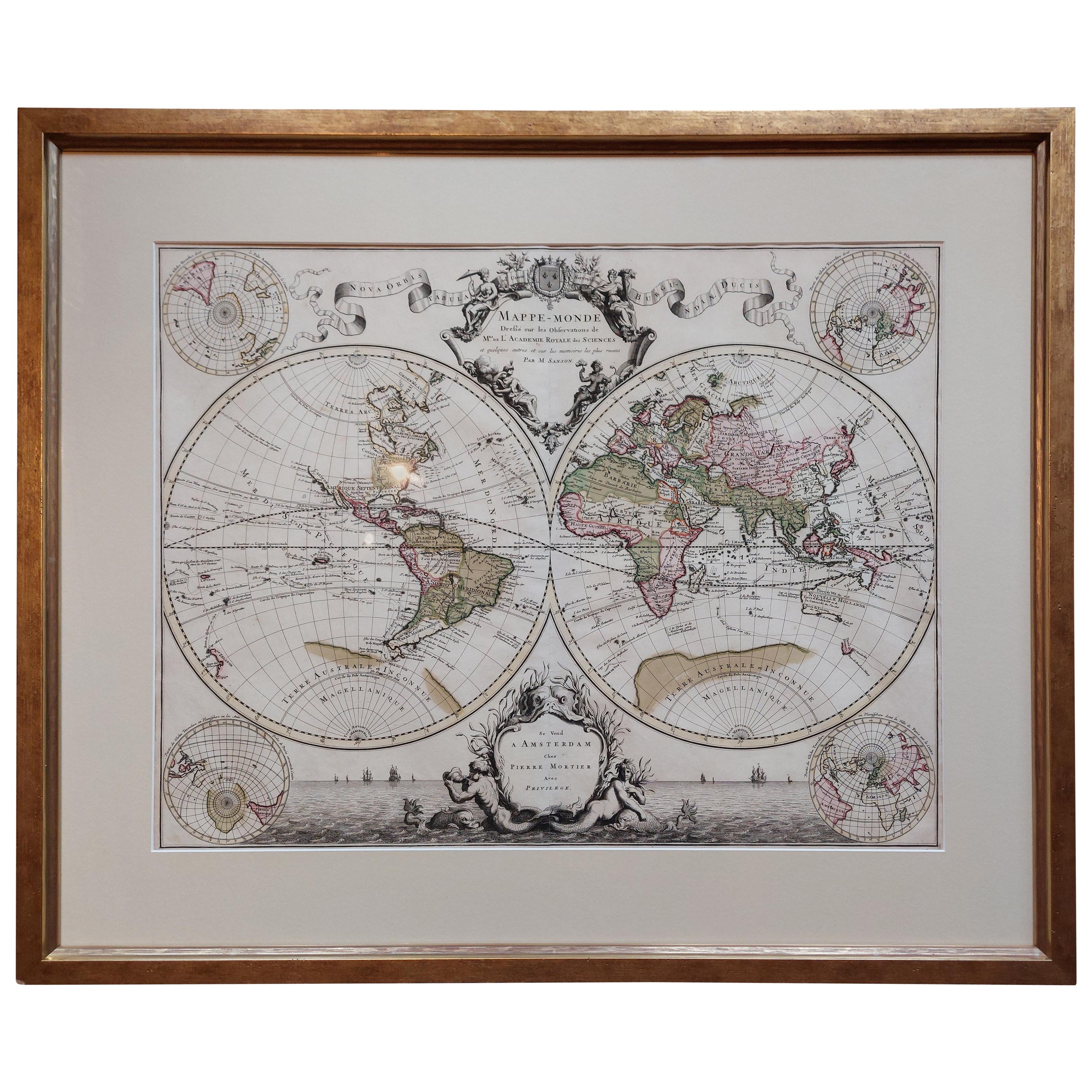
Original Antique Hand-colored World Map with or without Frame, '1696'
Located in Langweer, NL
Antique world map titled 'Mappe-Monde dressee sur les Observations de Mrs. de l'Academie Royale des Sciences (..)'. Beautiful original antique world map...
Category
Antique Late 17th Century French Maps
Materials
Paper

Antique World Map by P. Schenk '1706'
By Peter Schenk
Located in Langweer, NL
Antique map titled 'Diversa Orbis Terrae. Visu Incedente per Coluros Tropicorum, Ambos Ejus Polos, et Parciularis Sphaerae Zenith, in Planum Orthographica Projectio (..) Plat Ontwerp van verscheyde Aert-klooten (..)'. One of the earliest Dutch World Maps to focus on a more modern cartographic style, based on Carel Allard's map of 1696. This map represented a noteworthy shift from the traditional decorative Dutch 17th century maps where the margins would be full of classical mythological...
Category
Antique Early 18th Century Maps
Materials
Paper

$5,142 Sale Price
20% Off
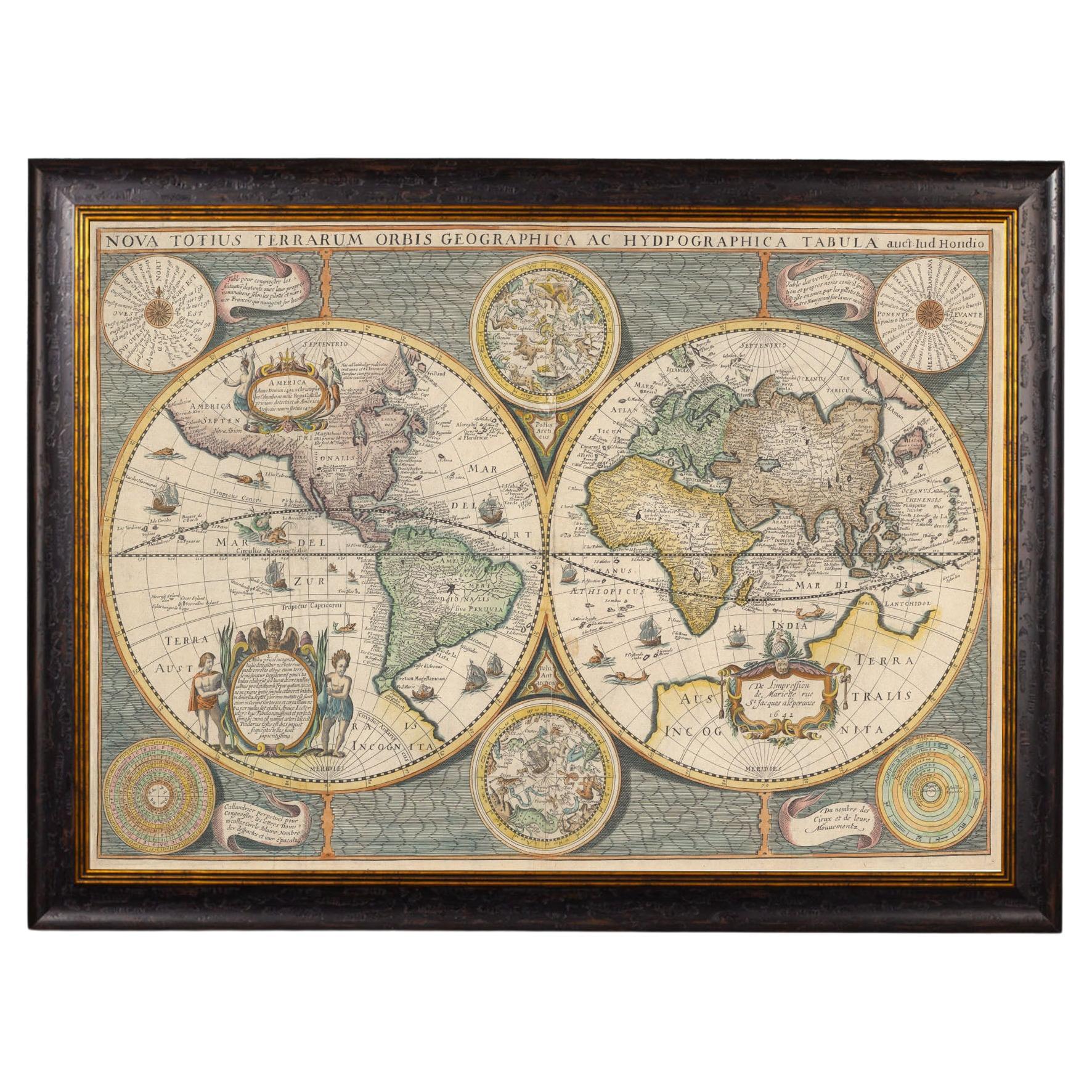
Framed World Map print showing double hemisphere dating to 1642 originally, New
Located in Lincoln, Lincolnshire
This is a digitally remastered World Map Conjuring up the golden age of exploration, from an original 1642 double hemisphere map of the world. It...
Category
2010s British Charles II Prints
Materials
Glass, Wood, Paper
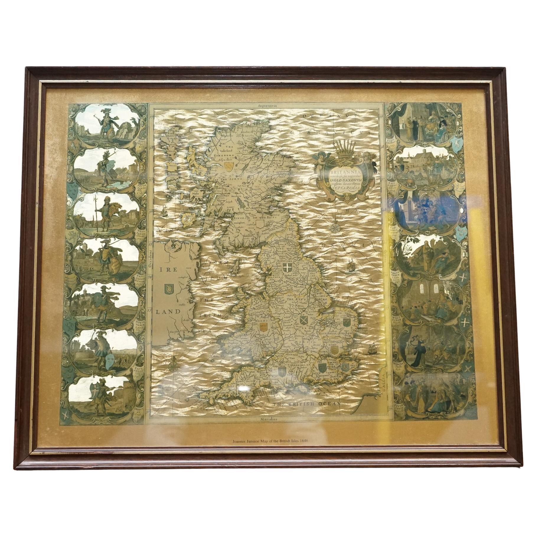
VINTAGE GOLD FOIL MAP OF THE BRITiSH ISLES 1646 BY JOANNES JANSSEN
Located in Pulborough, GB
We are delighted to offer for sale this lovely Vintage Gold Foil Map Of The British Isles 1646 By Joannes Janssen.
Please carefully examine the pictures to see the condition befor...
Category
20th Century British Decorative Art
Materials
Oak

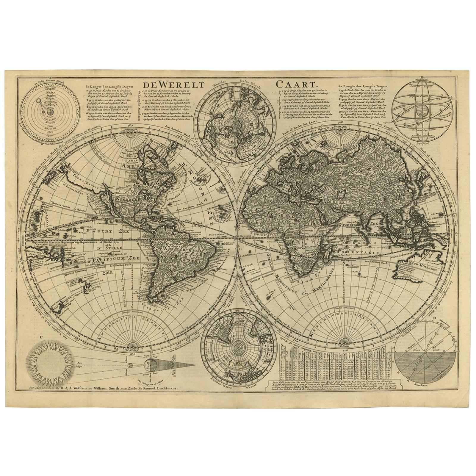
Antique Bible World Map by R. & J. Wetstein, 1743
Located in Langweer, NL
Antique world map titled 'De Werelt Caart'.
A scarce and richly detailed double hemisphere world map that was probably based on an earlier work by Cornelis Dankerts. This map has t...
Category
Antique Mid-18th Century Maps
Materials
Paper

Antique Map of the Eastern Hemisphere in Frame, 'circa 1683'
Located in Langweer, NL
Antique map titled 'Climats selon les Anciens'. Miniature map of the Eastern Hemisphere showing the climatic regions. This map originates from 'Description de l'Univers' by A.M. Mall...
Category
Antique Late 17th Century Maps
Materials
Paper
