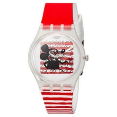
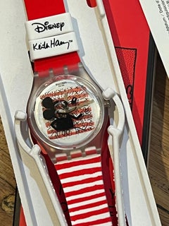
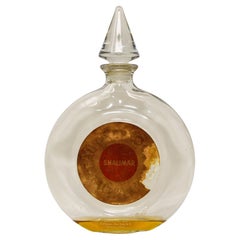
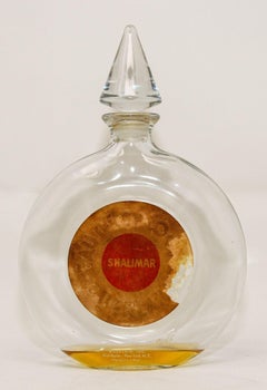
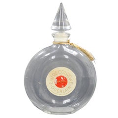
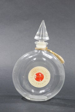
Map Collection

25
2,560
328
43
to
227
2,512
315
2,931
2,741
2,776
101
35
10
10
7
6
5
5
4
4
2
2
2
1
1
1,305
1,046
208
371
33
42
38
6
2
2
9
6
7
12
17
9
6
2,436
235
178
98
80
299
194
181
105
105
42
39
31
21
20
Sort By
18th Century French Map and City View of Joppe/Jaffa 'Tel Aviv' by Sanson
By Nicolas Sanson
Located in Alamo, CA
issues and curated his map collection and archives. Sanson created approximately three hundred maps and
Category

Antique Early 18th Century French Maps

Materials

Paper

Antique Map Made After a Roman Papyrus Travel Map, Known as Peutinger Map, 1773
Located in Langweer, NL
Old Dutch engraving with title: 'Romeinsche Reis Kaart van K. Peutinger'. Rare antique map based
Category

Antique 18th Century Maps

Materials

Paper

Antique Zoological Map, 1843
Located in Langweer, NL
decorators all over the world. Our collection includes a wide range of authentic antique maps from the 16th
Category

Antique 19th Century Maps

Materials

Paper

Antique Zoological Map, 1843
H 11.23 in W 8.94 in D 0 in
Antique Map of Greece with an Inset Map of Corfu, 1854
Located in Langweer, NL
interior decorators all over the world. Our collection includes a wide range of authentic antique maps from
Category

Antique 19th Century Maps

Materials

Paper

Antique Map of Denmark with an Inset Map of Iceland, 1832
Located in Langweer, NL
interior decorators all over the world. Our collection includes a wide range of authentic antique maps from
Category

Antique 19th Century Maps

Materials

Paper

Large Scale Map of Greece with Inset Map of Macedonia, c.1786
Located in Langweer, NL
interior decorators all over the world. Our collection includes a wide range of authentic antique maps from
Category

Antique 18th Century Maps

Materials

Paper

Antique Map of Friesland Also Know as the Peacock Map, C.1580
Located in Langweer, NL
Terrarum", the first modern "Atlas" with uniformly sized maps in a systematic collection. The term "Atlas
Category

Antique 18th Century Maps

Materials

Paper

Antique Map of Eastern Canada with an inset Map of Newfoundland, 1882
Located in Langweer, NL
interior decorators all over the world. Our collection includes a wide range of authentic antique maps from
Category

Antique 19th Century Maps

Materials

Paper

Antique Map of China, 1874
Located in Langweer, NL
interior decorators all over the world. Our collection includes a wide range of authentic antique maps from
Category

Antique 19th Century Maps

Materials

Paper

Antique Map of China, 1874
H 21.26 in W 14.77 in D 0 in
Antique Map of Asia, 1846
Located in Langweer, NL
decorators all over the world. Our collection includes a wide range of authentic antique maps from the 16th
Category

Antique 19th Century Maps

Materials

Paper

Antique Map of Asia, 1846
H 9.85 in W 12.41 in D 0 in
Antique Map of Greece with Two Small Inset Maps of Athens, c.1870
Located in Langweer, NL
collection includes a wide range of authentic antique maps from the 16th to the 20th centuries. Buying and
Category

Antique 19th Century Maps

Materials

Paper

Antique Map of France with Inset Map of the Island of Corsica, 1820
Located in Langweer, NL
Antique map titled 'France in Departments'. Old map of France, with small inset map of the island
Category

Antique 19th Century Maps

Materials

Paper

Attractive Antique Map of Italy with Inset of Maps Showing The Regions, c.1870
Located in Langweer, NL
over the world. Our collection includes a wide range of authentic antique maps from the 16th to the
Category

Antique 19th Century Maps

Materials

Paper

Antique Map of Asia by with an Inset Map of Turkey in Asia, 1868
Located in Langweer, NL
Antique map Asia titled 'Carte Politique et Ethnographique d'Asie'. Old map of Asia with an inset
Category

Antique 19th Century Maps

Materials

Paper

Antique Map of Africa and Arabia with Inset Map of Ethiopia and Eritrea, 1845
Located in Langweer, NL
decorators all over the world. Our collection includes a wide range of authentic antique maps from the 16th
Category

Antique 19th Century Maps

Materials

Paper

Antique Map of Denmark with Inset Maps of Iceland, Copenhagen and the Elbe, 1882
Located in Langweer, NL
Antique map titled 'Denmark with North-West portion of the German Empire comprising Schleswic
Category

Antique 19th Century Maps

Materials

Paper

Antique Political Map of France, 1880
By J. Migeon
Located in Langweer, NL
collection includes a wide range of authentic antique maps from the 16th to the 20th centuries. Buying and
Category

Antique 19th Century Maps

Materials

Paper

Antique Political Map of France, 1880
H 13.59 in W 18.71 in D 0 in
Antique Map of New Zealand, 1895
Located in Langweer, NL
Antique map titled 'Neu-Seeland.' Map of New Zealand. With inset maps of the large cities. This
Category

Antique 19th Century Maps

Materials

Paper

Antique Map of New Zealand, 1895
H 9.65 in W 6.3 in D 0 in
Antique World Map by Johnston, 1882
Located in Langweer, NL
over the world. Our collection includes a wide range of authentic antique maps from the 16th to the
Category

Antique 19th Century Maps

Materials

Paper

Antique World Map by Johnston, 1882
H 16.74 in W 24.18 in D 0 in
German Antique Map of Oceania, 1895
Located in Langweer, NL
decorators all over the world. Our collection includes a wide range of authentic antique maps from the 16th
Category

Antique 19th Century Maps

Materials

Paper

German Antique Map of Oceania, 1895
H 9.85 in W 12.21 in D 0 in
Antique Map of New Ireland, 1774
Located in Langweer, NL
the world. Our collection includes a wide range of authentic antique maps from the 16th to the 20th
Category

Antique 18th Century Maps

Materials

Paper

Antique Map of New Ireland, 1774
H 10.24 in W 14.18 in D 0 in
Antique Map of Westphalia, West Orientation
Located in Langweer, NL
Antique map titled 'Nova totius Westphaliae Descriptio'. Detailed map of Westphalia, Northern
Category

Antique Late 17th Century Maps

Materials

Paper

Antique Map of Westphalia, West Orientation
H 19.89 in W 24.1 in D 0.02 in
Antique Map of Southern Greece, 1892
Located in Langweer, NL
collection includes a wide range of authentic antique maps from the 16th to the 20th centuries. Buying and
Category

Antique 19th Century Maps

Materials

Paper

Antique Map of Southern Greece, 1892
H 10.04 in W 12.01 in D 0.01 in
Antique Map of France with an Inset Map of the Island of Corsica, c.1820
Located in Langweer, NL
Antique map titled 'Frankrijk naar de nieuwste bepalingen meerendeels gevolgd naar Lapie
Category

Antique 19th Century Maps

Materials

Paper

World Map Silver Leaf Print Based on Original Willem Blaeu Wall Map 1571-1638
Located in GB
We are delighted to offer for sale this lovely Antique style pictorial plan map of the globe based
Category

20th Century English Campaign Maps

Materials

Silver Leaf

Antique Map of Greece with an Inset Map of the Upper Danube Region, c.1720
Located in Langweer, NL
collection includes a wide range of authentic antique maps from the 16th to the 20th centuries. Buying and
Category

Antique 18th Century Maps

Materials

Paper

A Decorative Detailed Map of the Crimea, with an Inset Map of Sebastopol, c 1851
Located in Langweer, NL
, detailed and historically interesting mid 19th century map of the Crimea -- with an inset plan of
Category

Antique 1850s Maps

Materials

Paper

Antique Map of Delfland by Cruquius, 1712
Located in Langweer, NL
Map no. 25 of a large wall map of Delfland, The Netherlands. The map covers the region of Polder
Category

Antique 18th Century Maps

Materials

Paper

Eason's War Map of Europe, circa 1914
Located in Langweer, NL
the world. Our collection includes a wide range of authentic antique maps from the 16th to the 20th
Category

20th Century Maps

Materials

Paper

Eason's War Map of Europe, circa 1914
H 18.71 in W 24.41 in D 0 in
Antique Map of West Sumatra, Indonesia, 1900
Located in Langweer, NL
Antique map titled 'Sumatra, Bangka, Blitoeng en de Riouw-Archipel'. Old map of West Sumatra
Category

20th Century Maps

Materials

Paper

Antique Map of Turkey and Greece, 1852
Located in Langweer, NL
decorators all over the world. Our collection includes a wide range of authentic antique maps from the 16th
Category

Antique 19th Century Maps

Materials

Paper

Antique Map of Turkey and Greece, 1852
H 13.59 in W 10.63 in D 0 in
Antique Map of the Wadden Islands, 1792
Located in Langweer, NL
Antique map titled 'Der Vlie Strom'. Map of the Wadden islands with Vlieland in the middle (The
Category

Antique 18th Century Maps

Materials

Paper

Antique Map of the Wadden Islands, 1792
H 16.15 in W 11.42 in D 0 in
Antique Map of Turkey and Greece, 1842
By Pierre M. Lapie
Located in Langweer, NL
Antique map titled 'Carte de la Turquie d'Europe et de la Grèce Moderne'. Map of Turkey and Greece
Category

Antique 19th Century Maps

Materials

Paper

Antique Map of Turkey and Greece, 1842
H 26.78 in W 19.89 in D 0 in
Antique Map of Westergo in Friesland, 1791
Located in Langweer, NL
over the world. Our collection includes a wide range of authentic antique maps from the 16th to the
Category

Antique 18th Century Maps

Materials

Paper

Antique Map of Westergo in Friesland, 1791
H 11.42 in W 15.36 in D 0 in
Antique Political Map of Eastern China, 1922
Located in Langweer, NL
all over the world. Our collection includes a wide range of authentic antique maps from the 16th to
Category

20th Century Maps

Materials

Paper

Antique Tidal Chart and Botanical Map, 1843
Located in Langweer, NL
Two antique world maps on one sheet. The upper map is a tidal chart of the world and shows the
Category

Antique 19th Century Maps

Materials

Paper

Antique Map of the Niederrhein region, Germany
Located in Langweer, NL
Antique map titled 'Circulus Electorum Rheni sive Rhenanus Inferior (..)'. Original antique map of
Category

Antique Late 17th Century Maps

Materials

Paper

Antique Map of the Coromandel Peninsula, 1754
Located in Langweer, NL
maps to collectors, historians, educators and interior decorators all over the world. Our collection
Category

Antique 18th Century Maps

Materials

Paper

Antique Map of the Mongol Empire, 1767
Located in Langweer, NL
Antique map titled 'The Moguls Empire divided into its principal governments'. Old map of India
Category

Antique 18th Century Maps

Materials

Paper

Antique Map of the Mongol Empire, 1767
H 11.03 in W 8.67 in D 0 in
Antique Map of Franeker by Kuyper, 1868
Located in Langweer, NL
Antique map titled 'Provincie Friesland - Gemeente Franeker'. Map of the township of Franeker
Category

Antique 19th Century Maps

Materials

Paper

Antique Map of Franeker by Kuyper, 1868
H 7.88 in W 10.44 in D 0 in
Antique Map of Franekeradeel by Kuyper, 1868
Located in Langweer, NL
world. Our collection includes a wide range of authentic antique maps from the 16th to the 20th
Category

Antique 19th Century Maps

Materials

Paper

Antique Map of Groningen, the Netherlands, 1771
Located in Langweer, NL
collection includes a wide range of authentic antique maps from the 16th to the 20th centuries. Buying and
Category

Antique 18th Century Maps

Materials

Paper

Antique Map of Groningen, the Netherlands, 1771
No Reserve
H 12.21 in W 9.45 in D 0 in
Antique Map of Germany by Walker, 1820
By R. Walker
Located in Langweer, NL
decorators all over the world. Our collection includes a wide range of authentic antique maps from the 16th
Category

Antique 19th Century Maps

Materials

Paper

Antique Map of Germany by Walker, 1820
H 8.27 in W 10.24 in D 0 in
Antique Map of Friesland, The Netherlands, 1638
Located in Langweer, NL
interior decorators all over the world. Our collection includes a wide range of authentic antique maps from
Category

Antique 17th Century Maps

Materials

Paper

Antique Map of Greece and Macedonia, 1848
Located in Langweer, NL
world. Our collection includes a wide range of authentic antique maps from the 16th to the 20th
Category

Antique 19th Century Maps

Materials

Paper

Antique Map of Asia including Arabia, 1806
Located in Langweer, NL
decorators all over the world. Our collection includes a wide range of authentic antique maps from the 16th
Category

Antique 19th Century Maps

Materials

Paper

Antique Map of Asia including Arabia, 1806
H 10.44 in W 16.34 in D 0 in
Antique Map of Drenthe, The Netherlands, 1864
Located in Langweer, NL
Antique map titled 'De Provincie Drenthe'. Map of the province of Drenthe, the Netherlands. This
Category

Antique 19th Century Maps

Materials

Paper

Antique Map of the Europe Continent, 1880
Located in Langweer, NL
Antique map titled 'Europe'. Old map of the European continent. This map originates from
Category

Antique 19th Century Maps

Materials

Paper

Antique Map of the Europe Continent, 1880
H 13.59 in W 18.71 in D 0 in
Antique Map of Asia by Guthrie, 1787
Located in Langweer, NL
Antique map titled 'Asia from the best Authorities'. Old map of the Asian continent. This map
Category

Antique 18th Century Maps

Materials

Paper

Antique Map of Asia by Guthrie, 1787
H 8.47 in W 10.04 in D 0 in
Antique Map of France by Migeon, 1880
Located in Langweer, NL
interior decorators all over the world. Our collection includes a wide range of authentic antique maps from
Category

Antique 19th Century Maps

Materials

Paper

Antique Map of France by Migeon, 1880
H 13.59 in W 18.71 in D 0 in
Antique Map of The Asian Continent, 1855
Located in Langweer, NL
collection includes a wide range of authentic antique maps from the 16th to the 20th centuries. Buying and
Category

Antique 19th Century Maps

Materials

Paper

Antique Map of The Asian Continent, 1855
H 15.75 in W 20.87 in D 0 in
Antique Map of Bangka Island, Indonesia, 1885
Located in Langweer, NL
Antique map titled 'Kaart van het Eiland Banka. Old map of Bangka Island, or Banka. This map
Category

Antique 19th Century Maps

Materials

Paper

Antique Map of Buckinghamshire in England, 1743
Located in Langweer, NL
maps to collectors, historians, educators and interior decorators all over the world. Our collection
Category

Antique 18th Century Maps

Materials

Paper

Antique Map of Buckinghamshire in England, 1743
No Reserve
H 15.75 in W 20.48 in D 0 in
Antique Map of Greece and Macedonia, 1825
Located in Langweer, NL
interior decorators all over the world. Our collection includes a wide range of authentic antique maps from
Category

Antique 19th Century Maps

Materials

Paper

Antique Map of Belgium and Surroundings, 1692
Located in Langweer, NL
over the world. Our collection includes a wide range of authentic antique maps from the 16th to the
Category

Antique 17th Century Maps

Materials

Paper

Antique Map of France by Zannoni, 1765
Located in Langweer, NL
Antique map titled 'La France divisée en ses LVIII Provinces (..)'. Beautiful old map of France
Category

Antique 18th Century Maps

Materials

Paper

Antique Map of France by Zannoni, 1765
H 19.89 in W 19.69 in D 0 in
Antique Map of Asia by Gravius, 1788
Located in Langweer, NL
world. Our collection includes a wide range of authentic antique maps from the 16th to the 20th
Category

Antique 18th Century Maps

Materials

Paper

Antique Map of Asia by Gravius, 1788
H 8.08 in W 11.03 in D 0 in
Antique Map of Ambon Island, Indonesia, 1756
Located in Langweer, NL
maps to collectors, historians, educators and interior decorators all over the world. Our collection
Category

Antique 18th Century Maps

Materials

Paper

Antique Map of Old European Russia, 1846
Located in Langweer, NL
Antique map titled 'Russia in Europe'. Old map of European Russia. This map originates from 'A New
Category

Antique 19th Century Maps

Materials

Paper

Antique Map of Old European Russia, 1846
H 17.13 in W 13.78 in D 0 in
Antique Map of Asia by Delamarche, 1826
Located in Langweer, NL
all over the world. Our collection includes a wide range of authentic antique maps from the 16th to
Category

Antique 19th Century Maps

Materials

Paper

Antique Map of Asia by Delamarche, 1826
H 12.41 in W 17.72 in D 0 in
  • 1
  • ...
Get Updated with New Arrivals
Save "Map Collection", and we’ll notify you when there are new listings in this category.

Map Collection For Sale on 1stDibs

At 1stDibs, there are many versions of the ideal map collection for your home. Frequently made of paper, wood and metal, every map collection was constructed with great care. There are 2494 variations of the antique or vintage map collection you’re looking for, while we also have 291 modern editions of this piece to choose from as well. There are many kinds of the map collection you’re looking for, from those produced as long ago as the 18th Century to those made as recently as the 21st Century. A map collection made by modern designers — as well as those associated with mid-century modern — is very popular. Craft Associates, Lawrence Peabody and Johannes Janssonius each produced at least one beautiful map collection that is worth considering.

How Much is a Map Collection?

Prices for a map collection start at $13 and top out at $86,000 with the average selling for $289.