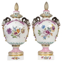
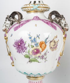
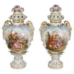
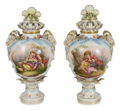
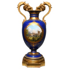
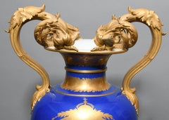
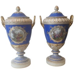
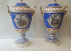
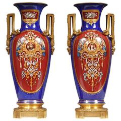
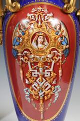
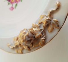
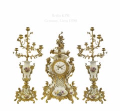
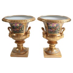
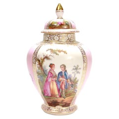
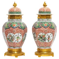
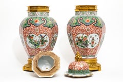
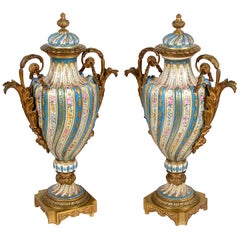
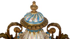
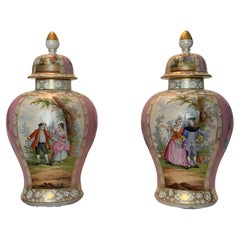
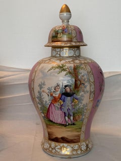
Map Of Berlin

5
to
41
218
155
160
128
98
87
86
75
46
31
31
26
21
20
18
17
13
10
8
8
7
6
6
6
5
4
3
3
3
3
2
2
2
2
2
1
1
1
1
1
1
1
1
1
1
42
42
39
19
15
Sort By
Antique Map of the German Empire by Johnston, '1909'
Located in Langweer, NL
of Berlin and Potsdam. This map originates from the ‘Royal Atlas of Modern Geography’. Published by W
Category

Early 20th Century Maps

Materials

Paper

Antique Map of the German Empire by Johnston, 1882
By Alexander Keith Johnston
Located in Langweer, NL
Antique map titled 'Empire of Germany'. Old map of the German Empire with an inset map of Berlin
Category

Antique 19th Century Maps

Materials

Paper

Antique Map of the City of Berlin in Germany, '1847'
Located in Langweer, NL
Antique map titled 'Berlin'. Original antique map of the city of Berlin, Germany. This map
Category

Antique Mid-19th Century Maps

Materials

Paper

Large Map of Germany with Berlin, Bremen, Hamburg, Osnabruck & Magdeburg, c.1680
Located in Langweer, NL
Antique map titled 'Circulus Saxoniae Inferioris in quo sunt Ducatus holsatiae, Meklenburg
Category

Antique 1680s Maps

Materials

Paper

18th Century Hand-Colored Homann Map of Germany, Including Frankfurt and Berlin
By Johann Baptist Homann
Located in Alamo, CA
An 18th century hand-colored map entitled "Tabula Marchionatus Brandenburgici et Ducatus Pomeraniae
Category

Antique Early 18th Century German Maps

Materials

Paper

Original Antique Map of Asia
Located in Langweer, NL
Antique map titled 'Asien'. Original old map of Asia. Published in Berlin by Simon Schropp et Comp
Category

Antique Early 19th Century Maps

Materials

Paper

Original Antique Map of Asia
H 21.86 in W 24.26 in D 0.02 in
Antique Map of New Ireland, 1774
Located in Langweer, NL
Antique print titled 'Neu Irrland (..)'. Antique map of New Ireland with 7 coastal profiles, Papua
Category

Antique 18th Century Maps

Materials

Paper

Antique Map of New Ireland, 1774
H 10.24 in W 14.18 in D 0 in
Antique Map of Greece with an Inset Map of the Upper Danube Region, c.1720
Located in Langweer, NL
Antique map titled 'Fluviorum in Europa principis Danubii cum adiacentibus Regnis.' Detailed map
Category

Antique 18th Century Maps

Materials

Paper

Antique Map of the Kingdom of Prussia, 1880
Located in Langweer, NL
gate of Brandenburg, Berlin. This map originates from 'Géographie Universelle Atlas-Migeon' by J
Category

Antique 19th Century Maps

Materials

Paper

Antique Map of Australia by H. Kiepert, 1875
Located in Langweer, NL
key in lower left. The map is prepared by H. Kiepert and published in Berlin by Dietrich Reimer
Category

Antique Late 19th Century Maps

Materials

Paper

Antique Map of Australia by H. Kiepert, 1875
H 19.1 in W 23.63 in D 0.02 in
Antique Map of part of Europe by Scherer, c.1703
Located in Langweer, NL
Untitled map of Europe depicting Calais, Münster, Paris, Lion, Prag, Wien, Berlin, Clermont and
Category

Antique 18th Century Maps

Materials

Paper

Antique Map of the Rhine centered on Cologne, Germany
Located in Langweer, NL
Antique map titled 'Archiepsiscopatus et Electoratus Coloniensis (..)'. Original antique map of the
Category

Antique Early 18th Century Maps

Materials

Paper

Detailed Antique Map of the Lower Rhine region, Germany
Located in Langweer, NL
Antique map titled 'S.R.I. Circulus Rhanus Inferior sive Electorum Rheni (..)'. Detailed map of the
Category

Antique Mid-18th Century Maps

Materials

Paper

Antique Map of Czech Republic by I. Tirion, 1747
Located in Langweer, NL
Antique map titled 'Nieuwe Kaart van t Koninkryk Bohemen t Hertogdom Silesien markgraafschap
Category

Antique Mid-18th Century Maps

Materials

Paper

Antique Map of the Seventeen Provinces of Netherlands, Belgium, Luxembourg, 1748
By Homann Heirs
Located in Langweer, NL
Antique map titled 'Belgii Universi seu Inferioris Germaniae quam XVII Provinciae (..)'. Map of
Category

Antique 18th Century Maps

Materials

Paper

Antique Map of the Islands of Denmark by Homann Heirs, 1720
Located in Langweer, NL
Antique map titled 'Insula Danicae in Mari Balthico sitae (..).' - Map of the Danish islands
Category

Antique 18th Century Maps

Materials

Paper

Antique Map of Switzerland by Homann Heirs, c.1732
Located in Langweer, NL
important map and atlas producer in Germany. He became a member of the Academy of Science in Berlin just
Category

Antique 18th Century Maps

Materials

Paper

Original Antique Coloured Map of Western Africa, Published in 1882
Located in Langweer, NL
This is a map of Western Africa from the 1882 Blackie & Son atlas. The map details the West African
Category

Antique 1880s Maps

Materials

Paper

Antique Map of the Region of Elbogen & Eger, Czech Republic & Hungary, 1742
Located in Langweer, NL
Antique map titled 'Repraesentatio Geographica Circuli Egerani, nec non Elnbogensis : in quo simul
Category

Antique 1740s Maps

Materials

Paper

Antique Map of the Region of Paris by Homann Heirs, c.1720
By Homann Heirs
Located in Langweer, NL
Antique map titled 'Agri Parisiensis Tabula particularis, qua maxima Pars Insulae Franciae
Category

Antique 18th Century Maps

Materials

Paper

Antique Map of the Region of Orleans by Homann Heirs, c.1760
By Homann Heirs
Located in Langweer, NL
Antique map titled 'Novissima Totius Aureliani Generalitatis (..) - Nouvelle Carte du Gouvernement
Category

Antique 18th Century Maps

Materials

Paper

Antique Map of Western Europe by H. Kiepert, circa 1870
By Heinrich Kiepert
Located in Langweer, NL
Antique map titled 'Gallia, Britannia, Germania'. This map depicts a large part of Western Europe
Category

Antique Late 19th Century Maps

Materials

Paper

Antique Map of Northern Germany by M. Seutter, circa 1730
By Matthew Seutter
Located in Langweer, NL
Antique map titled 'Saxoniae Inferioris Circulus'. Old map of the northern part of Germany by M
Category

Antique Mid-18th Century Maps

Materials

Paper

Antique Map of Vlaams-Brabant by Homann Heirs, c.1720
By Homann Heirs
Located in Langweer, NL
Antique map titled 'Ducatus Brabantiae Nova Tabula in qua (..).' Fully engraved copper plate map
Category

Antique 18th Century Maps

Materials

Paper

Antique Map of the Santa Cruz Islands by Hawkesworth, 1774
Located in Langweer, NL
and Engravers: Published by Haude & Spener, Berlin. Condition: Very good, general age-related
Category

Antique 18th Century Maps

Materials

Paper

Antique Map of the Bay of Cordes and Surroundings by Hawkesworth, 1774
Located in Langweer, NL
Antique print titled 'Baye et Havre de Cordes (..)'. Four maps on the one sheet of; Cordes Bay
Category

Antique 18th Century Maps

Materials

Paper

Antique Map of the Seventeen Provinces by Homann Heirs, 1748
By Homann Heirs
Located in Langweer, NL
Antique map titled 'Belgii Universi seu Inferioris Germaniae quam XVII Provinciae (..)'. Map of the
Category

Antique 18th Century Maps

Materials

Paper

Antique Map of the Beaujolais Region by Homann Heirs, 1762
Located in Langweer, NL
Antique map titled 'La Generalite Proprie Taire De Lyon (..) - Propriae Lugudunensis Generalitatis
Category

Antique 18th Century Maps

Materials

Paper

Antique Map of Northern Italy by Homann Heirs, c.1730
Located in Langweer, NL
Antique map titled 'Domini Veneti cum vicinis Parmae Mutinae, Matuae et Mirandol (..).' Detailed
Category

Antique 18th Century Maps

Materials

Paper

Antique Map of Belgium and Luxembourg by Homann Heirs, 1747
Located in Langweer, NL
Antique map titled 'Belgium Catholicum seu Decem provinciae Germaniae Inferioris cum confiniis
Category

Antique 18th Century Maps

Materials

Paper

Antique Map of Flanders, Belgium by Homann Heirs, c.1735
Located in Langweer, NL
Antique map titled 'Comitatus Flandriae in omnes ejusdem subjecentes Ditioes (..).' Original
Category

Antique 18th Century Maps

Materials

Paper

Antique Map of Belgium and Luxembourg by Homann Heirs, 1747
Located in Langweer, NL
Antique map titled 'Belgium Catholicum seu Decem provinciae Germaniae Inferioris cum confiniis
Category

Antique 18th Century Maps

Materials

Paper

Antique Map of Europe with Elaborate Title Cartouche, c.1750
Located in Langweer, NL
Antique map of Europe titled 'Europa Secundum legitimas Projectionis Stereographicae regulas et
Category

Antique 18th Century Maps

Materials

Paper

Map of Duchy of Brabant Centered on Fortress of Louvain or Leuven, Belgium, 1720
Located in Langweer, NL
Antique map titled 'Ducatus Brabantiae Nova Tabula in qua Lovanii Bruxellarum March S. Impreii
Category

Antique 1720s Maps

Materials

Paper

Antique Map of the Waldeck Region of Germany by Homann Heirs, circa 1733
By Homann Heirs
Located in Langweer, NL
Antique map titled 'Waldecciae ac finitimorum Dominiorum (.)'. Map of the Waldeck region of Germany
Category

Antique 18th Century Maps

Materials

Paper

Antique Map of Part of the Roman Empire by H. Kiepert, circa 1870
By Heinrich Kiepert
Located in Langweer, NL
Antique map titled 'Imperia Persarum et Macedonum'. Depicts part of the Roman Empire, from Greece
Category

Antique Late 19th Century Maps

Materials

Paper

Unusual Benedictine Map of Italy, Showing Various States of the Church, C.1745
Located in Langweer, NL
Antique map titled 'Italia Benedictina Delineata A.P.R.C.P.W.' Unusual Benedictine map of Italy
Category

Antique 18th Century Maps

Materials

Paper

Antique Map of Russia and Central Asia, showing the Northeast Passage
Located in Langweer, NL
important map and atlas producer in Germany. He became a member of the Academy of Science in Berlin just
Category

Antique Mid-18th Century Maps

Materials

Paper

Antique Map of Egypt and Palestina by H. Kiepert 'circa 1870'
By Heinrich Kiepert
Located in Langweer, NL
Antique map titled 'Aegyptus, Phoenice et Palestina'. With inset maps of Tyrus, Alexandria and
Category

Antique Late 19th Century Maps

Materials

Paper

Antique Map of Italy and Greece by H. Kiepert, circa 1870
By Heinrich Kiepert
Located in Langweer, NL
Antique map titled 'Italiae pars media'. This map originates from 'Atlas Antiquus. Zwölf Karten zur
Category

Antique Late 19th Century Maps

Materials

Paper

Antique Map of the Lower Saxony Region by Homann, c.1730
By Johann Baptist Homann
Located in Langweer, NL
Antique map titled 'Circulus Saxoniae Inferioris (..)'. Map of the Circle of Lower Saxony. The map
Category

Antique 18th Century Maps

Materials

Paper

Antique Map of Mozambique and Cape of Good Hope with Kingdom Monomotapa, 1780
Located in Langweer, NL
Antique map titled 'Carte Du Canal De Mozambique.' The main map, on the right, covers from the Cape
Category

Antique 18th Century Maps

Materials

Paper

Antique Map of the Baltic Region by Homann Heirs, c.1730
Located in Langweer, NL
Antique map titled 'Regnum Borussiae gloriosis auspicijs Seerenissimi et Potentissimi Princip
Category

Antique 18th Century Maps

Materials

Paper

Antique Map of Denmark with the Danish Royal Crest, c.1730
By Homann Heirs
Located in Langweer, NL
Antique map titled 'Regni Daniae in quo sunt Ducatus Holsatia and Slesuicum Insulae Danicae Jutia
Category

Antique 18th Century Maps

Materials

Paper

Detailed Old Map of the Seven Provinces of the Belgian/Dutch Federation, ca.1748
Located in Langweer, NL
Antique map titled 'Septem Provinciae seu Belgium Foederatum quod generliter Hollandia
Category

Antique 18th Century Maps

Materials

Paper

Old 18th Century Composite Map of Key Caribbean Islands with Descriptive Texts
Located in Langweer, NL
Antique map titled 'Dominia Anglorum in praecipuis Insulis Americae ut sunt Insula S. Christophori
Category

Antique 1740s Maps

Materials

Paper

Antique Map of Denmark with Schleswig-Holstein and the South of Sweden, c.1750
Located in Langweer, NL
Antique map titled 'General Charte von Konigreich Daenemark nebst dem Herzogthum Holstein.' Denmark
Category

Antique 18th Century Maps

Materials

Paper

Antique Map of the Rhine centered on Cologne, Germany, with outline coloring
Located in Langweer, NL
Antique map titled 'Archiepsiscopatus et Electoratus Coloniensis (..)'. Original antique map of the
Category

Antique Early 18th Century Maps

Materials

Paper

Antique Map of the Rhine centered on Cologne, Germany, with original coloring
Located in Langweer, NL
Antique map titled 'Archiepsiscopatus et Electoratus Coloniensis (..)'. Original antique map of the
Category

Antique Early 18th Century Maps

Materials

Paper

Antique Map of Spain, Mauritia and Africa by H. Kiepert, circa 1870
By Heinrich Kiepert
Located in Langweer, NL
Antique map titled 'Hispania, Mauretania et Africa'. This map originates from 'Atlas Antiquus
Category

Antique Late 19th Century Maps

Materials

Paper

Antique Map of a Bay Nearby Makassar, Celebes 'Sulawesi)' by Hawkesworth, 1774
Located in Langweer, NL
Antique map titled 'Vue de la Baye de Bonthain (..)'. Map of the island Sulawesi (Celebes
Category

Antique 18th Century Maps

Materials

Paper

Antique Map of the Caspian Sea, Uzbekistan, Northern Persia Etc, C.1735
Located in Langweer, NL
Antique map titled 'Nova Maris Caspii et Regions Usbeck (..).' Detailed map of Central Asia
Category

Antique 18th Century Maps

Materials

Paper

Regional Map of Germany, inc Hamburg, Luneberg, Hannover, Braunsweig etc, c.1720
Located in Langweer, NL
Antique map titled 'Ducatus Luneburgici et Comitatus Dannebergensis accurata Descriptio.' This
Category

Antique 1720s Maps

Materials

Paper

Detailed Antique Map of Slavonia, the Region in Eastern Croatia, ca.1745
Located in Langweer, NL
Antique map titled 'Tabula Geographica exhibens Regnum Sclavoniae.' Detailed map of Slavonia
Category

Antique 1740s Maps

Materials

Paper

Antique European War Folding Map, ‘circa 1915’
Located in Langweer, NL
Antique folding map of the European War (1914-1915) titled 'The Eastern Campaign '. From Petrograd
Category

Early 20th Century Maps

Materials

Paper

Old Map of Region Champagne-Ardenne with Reims, Troyes & Épernay in France, 1759
Located in Langweer, NL
Antique map titled 'Tabula Geographica Campaniae (..).' Detailed map of the Champagne region in
Category

Antique 1750s Maps

Materials

Paper

Antique Map of the Savoy and Piedmont Regions, Centered on Torino, ca.1735
Located in Langweer, NL
Antique map titled 'Ducatus Sabaudiae, Principatus Pedemontium et ducatis Montisferrati
Category

Antique 1730s Maps

Materials

Paper

Antique Map of the Danube River and Surroundings by Homann Heirs, c.1730
By Homann Heirs
Located in Langweer, NL
Antique map titled 'Danubii Fluminus (a fontibus prope Doneschingam usq Posonium urbem defignati
Category

Antique 18th Century Maps

Materials

Paper

Antique Map of London Showing the Area from Essex to Surrey, England, 1741
Located in Langweer, NL
Antique map titled 'Regionis quae est circa Londinum specialis repraesentatio (..)' Very detailed
Category

Antique 18th Century Maps

Materials

Paper

Original Old Map of St Kitts, Antigua, Bermuda, Barbados, and Jamaica, ca.1745
Located in Langweer, NL
Antique map titled 'Dominia Anglorum in praecipuis Insulis Americae ut sunt Insula S. Christophori
Category

Antique 1740s Maps

Materials

Paper

  • 1
Get Updated with New Arrivals
Save "Map Of Berlin", and we’ll notify you when there are new listings in this category.

Map Of Berlin For Sale on 1stDibs

Find the exact map of berlin you’re shopping for in the variety available on 1stDibs. Find modern versions now, or shop for modern creations for a more modern example of these cherished works. You’re likely to find the perfect map of berlin among the distinctive items we have available, which includes versions made as long ago as the 18th Century as well as those made as recently as the 21st Century. Adding a map of berlin to a room that is mostly decorated in warm neutral tones can yield a welcome change — find a piece on 1stDibs that incorporates elements of gray, black, brown, blue and more. Creating a map of berlin has been a part of the legacy of many artists, but those crafted by (after) Henri Matisse, Henri Matisse, Helmut Newton, Catherine Bolduc and Alexander Ross are consistently popular. Artworks like these of any era or style can make for thoughtful decor in any space, but a selection from our variety of those made in paint, lithograph and oil paint can add an especially memorable touch.

How Much is a Map Of Berlin?

A map of berlin can differ in price owing to various characteristics — the average selling price for items in our inventory is $1,707, while the lowest priced sells for $79 and the highest can go for as much as $175,000.