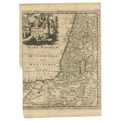

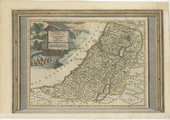
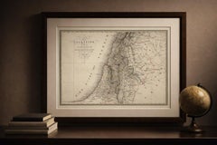
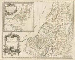
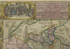
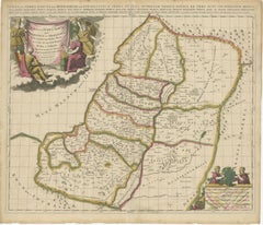
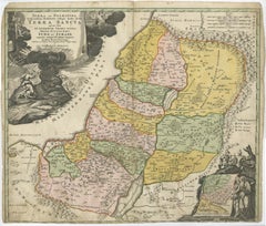
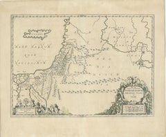
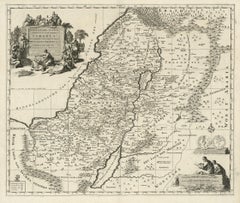
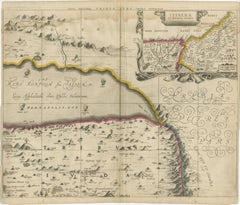
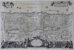
Antique Map of the Holy Land, c.1710
Located in Langweer, NL
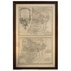
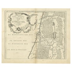
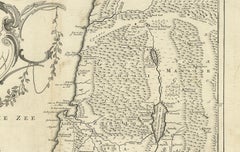
Antique map titled 'Totius Terrae Sanctae Delineatio'. Map of the Holy Land extending to Egypt and
Category
Antique 18th Century Maps
Materials
Paper
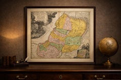
Antique Map of the Holy Land, c.1710
Located in Langweer, NL
Antique map titled 'Totius Terrae Sanctae Delineatio'. Map of the Holy Land extending to Egypt and
Paper

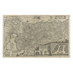
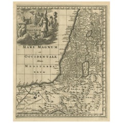
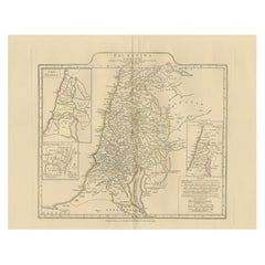
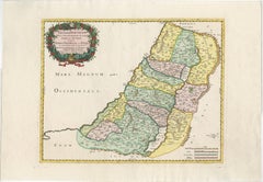
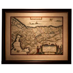
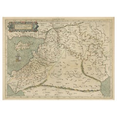
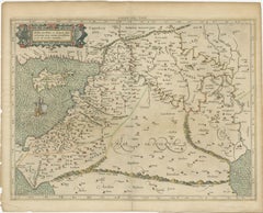
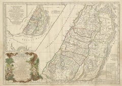
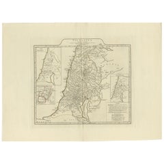
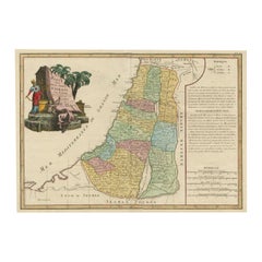
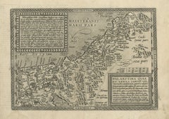
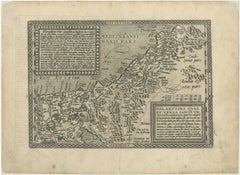
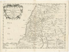
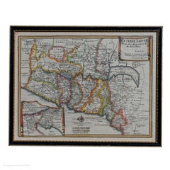
Antique Map of the Holy Land, c.1717
Located in Langweer, NL
Holy Land by J. Bonfrerius. The map is oriented with north at top left and divided into the twelve
Paper

$803Sale Price|20% Off
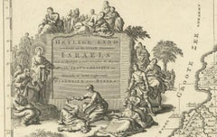
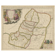
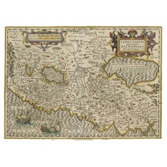
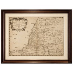
Beautiful Rare Antique Map of the Holy Land, 1648
Located in Langweer, NL
Antique map Holy Land titled 'Perigrinatie ofte Veertich-Iarige Reyse, der kinderen Israels uyt
Paper


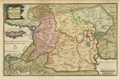
Antique Map of the Holy Land by Schut, 1710
Located in Langweer, NL
Antique map of the Holy Land titled 'Het Beloofde Landt Canaan.' Very detailed and decorative map
Paper


Antique Map of the Holy Land by Keur, 1748
Located in Langweer, NL
Antique Map Holy Land titled 'De Gelegentheyd van t'Paradys ende t'Landt Canaan, Mitsgaders d'eerst
Paper
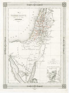
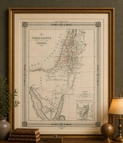
Holy Land Map, Jerusalem & Sinai — Dufour Biblical Map, Paris 1846
Located in Langweer, NL
Title: Holy Land Map, Jerusalem & Sinai — Dufour Biblical Map, Paris 1846 This elegant and
Paper
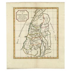

Antique Map of the Holy Land by Delamarche, 1806
By Charles Francois Delamarche
Located in Langweer, NL
Antique map titled 'Judee ou Terre Sainte sous les Turcs.' This map shows the holy land under the
Paper
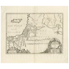
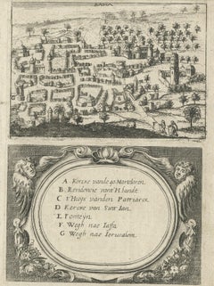
Antique Map Holy Land & Jerusalem — Patriarchatus Hierosolymitani, c1652
Located in Langweer, NL
Antique Map Holy Land & Jerusalem — Patriarchatus Hierosolymitani, c1652 A finely engraved mid
Paper
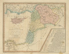
Kingdom of Jerusalem Map, Crusades Holy Land Cyprus, Wilkinson 1817
Located in Langweer, NL
Kingdom of Jerusalem Map, Crusades Holy Land Cyprus, Wilkinson 1817 This finely engraved and
Paper

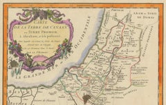
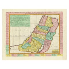
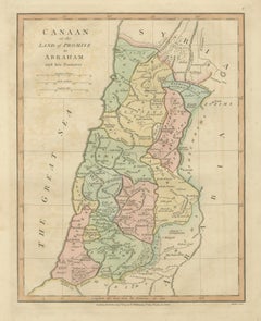
1750 Map of the Holy Land: The Land of Canaan and the Twelve Tribes
Located in Langweer, NL
. Robert in 1750 and vividly illustrates the geography of the Holy Land as described in the Bible. The map
Paper
$841Sale Price|20% Off
Antique Map of the Holy Land with Picture Frame Border
Located in Langweer, NL
Holy Land with the picture frame border. The term "Holy Land" usually refers to a territory roughly
Paper

$372Sale Price|20% Off
Original Antique Map of the Holy Land with Decorative Cartouche
Located in Langweer, NL
Antique map titled 'Totius Terrae Sanctae'. Original old map of the Holy Land, with a large
Paper


Antique Map of the Holy Land by Danckerts, c.1710
Located in Langweer, NL
de Roode Zee en de Woestyne tot in 't Beloofde Landt Canaan'. Map of the Holy Land divided into the
Paper

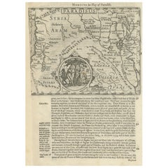
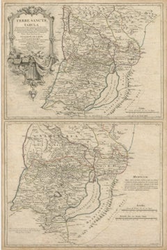
Antique Map of the Holy Land and Paradise – Terrae Canaan Map, c.1720
Located in Langweer, NL
Antique Map of the Holy Land and Paradise by François Halma, c.1720 Beautiful early 18th-century
Paper
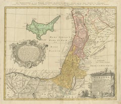
Antique Map of Palestine and the Holy Land – Lapie, Paris, 1838
Located in Langweer, NL
Antique Map of Palestine and the Holy Land – Lapie, Paris, 1838 This elegant and finely engraved
Paper
Antique Map of Biblical Palestine – Holy Land & Jerusalem Insets, c.1818
Located in Langweer, NL
Antique Map of Biblical Palestine – Holy Land & Jerusalem Insets, c.1818 Elegant antique map
Paper

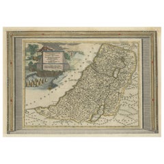
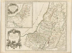
1718 Holy Land Map - Twelve Tribes, Six Provinces, Hand-Colored, Antique Map
Located in Langweer, NL
45.7 cm (14.7 x 18.0 inches) --- This finely engraved, hand-colored map of the Holy Land, produced
Paper


Antique Map of the Holy Land by Van Luchtenburg, c.1720
Located in Langweer, NL
Antique map titled 'Heylige Land verdeeld in de Twaalf Stammen Israels (..).' Highly detailed map
Paper
$458Sale Price|20% Off
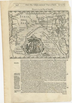
Antique Map of the Holy Land, with vignette of the Garden of Eden
Located in Langweer, NL
Antique map titled 'Hondius his Map of Paradise'. Beautiful map of the region bounded by the Holy
Paper
Holy Land Map Palestine Homann Heirs, Hand Colored, c.1744
Located in Langweer, NL
Holy Land Map Palestine Homann Heirs, Hand Colored, c.1744 This finely engraved and original hand
Paper

Antique Holy Land Map, Twelve Tribes of Israel – Covens & Mortier, c.1700
Located in Langweer, NL
Antique Holy Land Map, Twelve Tribes of Israel – Covens & Mortier, c.1700 Description: This
Paper
Holy Land Map of the Twelve Tribes of Israel – Sanson, Hand Colored, 1696
Located in Langweer, NL
Holy Land Map of the Twelve Tribes of Israel – Sanson, Hand Colored, 1696 Description: This
Paper
Antique French Map of the Holy Land, Twelve Tribes of Israel, c.1750
Located in Langweer, NL
Antique Holy Land Map, Twelve Tribes of Israel – Robert de Vaugondy, c.1750 Description This
Paper
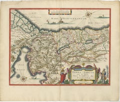
Blaeu Holy Land Map, Terra Sancta Palestina, Figural Cartouche, 1642
Located in Langweer, NL
Blaeu Holy Land Map, Terra Sancta Palestina, Figural Cartouche, 1629 A highly decorative and
Paper
1625 Petrus Plancius / Cloppenburg Map of the Holy Land with Biblical Vignettes
Located in Langweer, NL
1625 Petrus Plancius / Johannes Cloppenburg Map of the Holy Land with Biblical Vignettes This
Paper
$659Sale Price|20% Off
Mercator's Ptolemaic Map of the Holy Land, Cyprus and Syria, circa 1580
Located in Langweer, NL
Antique map titled 'Asiae IIII Tab'. Beautiful map of Mercator's Ptolemaic map of the Holy Land
Paper
$1,147Sale Price|20% Off
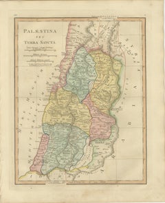
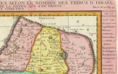
Antique Map of the Holy Land, Showing the Location of the Various Tribes
Located in Langweer, NL
Holy Land, showing the location of the various tribes, in two kingdoms, Judah and Israel as well as in
Paper
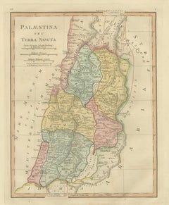
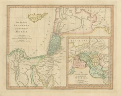
Holy Land Map — Palestina seu Terra Sancta, Biblical Geography, Wilkinson 1819
Located in Langweer, NL
Holy Land Map — Palestina seu Terra Sancta, Biblical Geography, Wilkinson 1819 This finely
Paper

Holy Land Map of the Twelve Tribes of Israel, After Sanson, Paris c.1798
Located in Langweer, NL
-François Delamarche, circa 1798. Large engraved biblical map of the Holy Land showing the division of the
Paper
Holy Land Map Judaea Palestina, Homann Engraving, Hand Colored c.1710
Located in Langweer, NL
Holy Land Map Judaea Palestina, Homann Hand Colored, c.1710 Authentic early 18th c. decorative map
Paper
Antique Biblical Holy Land Map — Jerusalem, Palestine & Levant, De Fer 1703
Located in Langweer, NL
Antique Biblical Holy Land Map — Jerusalem, Palestine & Levant, De Fer 1703 This finely engraved
Paper
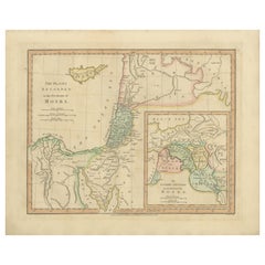
Places Recorded in the Five Books of Moses — Biblical Holy Land Map, 1827
Located in Langweer, NL
Places Recorded in the Five Books of Moses — Biblical Holy Land Map, Wilkinson 1827 This finely
Paper

Antique Biblical Map of the Holy Land – Janssonius Abraham Isaac Jacob, c. 1650
Located in Langweer, NL
Antique Biblical Map of the Holy Land – Janssonius Abraham Isaac Jacob, c. 1650 This finely
Paper
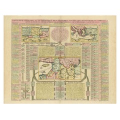
1773 John Blair Map of the Ancient Holy Land: Tribes, Journeys, and Empires
Located in Langweer, NL
Title: 1773 John Blair Map of the Ancient Holy Land: Tribes, Journeys, and Empires This
Paper
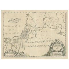
Decorative Map of the Holy Land, Wanderings of Moses by Pieter Mortier, ca. 1700
Located in Langweer, NL
Decorative Map of the Holy Land, Wanderings of Moses by Pieter Mortier, ca. 1700 Antique
Paper
1732 Henri Chatelain Map of the Holy Land Divided Among the Tribes of Israel
Located in Langweer, NL
Title: 1732 Henri Chatelain Map of the Holy Land Divided Among the Tribes of Israel This
Paper
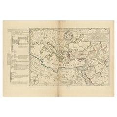
1767 D’Anville Map of the Holy Land: Ancient Divisions and Biblical Geography
Located in Langweer, NL
Ancient Map of Palestine or the Holy Land by D'Anville (1767) This detailed map, created by the
Paper
Moullart-Sanson Map of the Holy Land and Sacred Geography of the Old Testament
Located in Langweer, NL
"1716 Moullart-Sanson Map of the Holy Land and Sacred Geography of the Old Testament" This
Paper
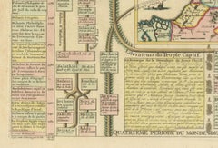
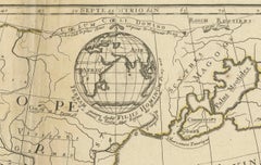
Biblical Map and Family Trees of the Holy Land by Chatelain, ca. 1720
Located in Langweer, NL
Title: 1720 Chatelain Map of the Holy Land with Biblical Family Trees and Chronology Description
Paper
Antique Map of the Holy Land, showing the travels of Abraham, Isaac and Jacob
Located in Langweer, NL
regional map of the Holy Land, showing the travels of Abraham, Isaac and Jacob. Published by J. Janssonius
Paper

$659Sale Price|20% Off
Original Rare Map of the Holy Land Showing the Twelve Tribes of Israel's, 1782
Located in Langweer, NL
Antique map titled 'Carte des Douze Tribus D'Israel (..).' Map of the Holy Land showing the
Paper
Holy Land Map – Terra Sancta Palestina, Hondius, Hand-Colored Engraving c.1620
Located in Langweer, NL
Holy Land Map – Terra Sancta Palestina, Hondius, Hand-Colored Engraving c.1620 This finely
Paper


1720 Maps of the Holy Land: Ancient and Modern by De Fer and Danet
Located in Langweer, NL
1720 Maps of the Holy Land: Ancient and Modern by De Fer and Danet This set of two 1720 maps
Paper
Antique Holy Land Map, Terrae Sanctae Tabula – Guillaume De L’Isle, 1782
Located in Langweer, NL
Antique Holy Land Map, Terrae Sanctae Tabula – Guillaume De L’Isle, 1782 A finely engraved and
Paper
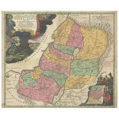
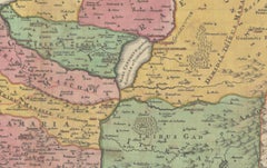
Hand-Colored Map of the Holy Land Divided Among the Twelve Tribes, c.1720
Located in Langweer, NL
Hand-Colored Map of the Holy Land Divided Among the Twelve Tribes, c.1720 This striking antique
Paper

$458Sale Price|20% Off
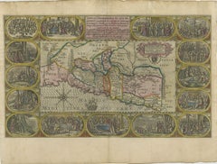
Highly Detailed Antique Map of the Holy Land Showing 12 Tribes of Israel, c.1720
Located in Langweer, NL
map of the Holy Land divided into 12 tribes of Israel. With beautiful large title cartouche, vignette
Paper
Rare 16th Century Map of the Holy Land and Palestine by Matthias Quad, ca.1599
Located in Langweer, NL
Title: Rare 16th Century Map of the Holy Land and Palestine by Matthias Quad Description: This
Paper
$3,537Sale Price / set|20% Off
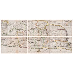
1658 Large Map of the Holy Land by Jansson – Twelve Tribes of Israel in 6 Sheets
Located in Langweer, NL
Holy Land Divided Among the Twelve Tribes – Six-Part Map by Jan Jansson and Georgius Hornius, circa
Paper
Holy Land Antique Map — Palestine, Syria, Levant Region, De la Rue Paris c1700
Located in Langweer, NL
Holy Land Unframed Antique Map — Palestine, Syria, Levant Region, De la Rue Paris c1700 This
Paper
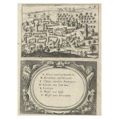
Rare Map of Rama or Ramma 'Ramallah?' in Palestine or the Holy Land, ca.1730
Located in Langweer, NL
Antique map titled 'Rama'. This maps shows a view of Ramma (Ramallah?) in Palestine or the Holy
Paper

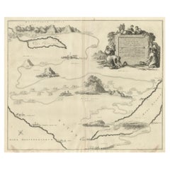
The Holy Land at the Time of Jesus: A 17th Century Dutch Map by Visscher
By Nicolaes Visscher II
Located in Alamo, CA
discoloration. The map is otherwise in excellent condition. Another map of the "Holy Land" (a city view of
Paper


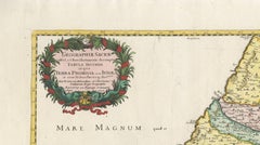
Antique Map of the Holy Land Described in the Old and New Testament, ca.1660
Located in Langweer, NL
Antique map titled 'Geographiae Sacrae ex Veteri et Novo Testamento Desumptae Tabula Prima quae
Paper


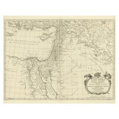
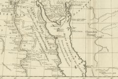
Map of the Holy Land "Carte de la Syrie et de l'Egypte" by Pierre M. Lapie
By Pierre M. Lapie
Located in Alamo, CA
engraved by Armand Joseph Lellemand (1810-1871). The map depicts the Holy Land and Egypt as it existed at
Paper

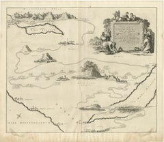
Map Holy Land La Terre Sainte Engraved van Loon Published N de Fer 1703 French
Located in BUNGAY, SUFFOLK
Majeste Catoliq et de Monseigneur le Dauphin. Avec Privil du Roi 1703 Detailed map of the Holy Land
Paper
The Land of Promise — Elegant Hand-Colored Biblical Map of Canaan, London 1827
Located in Langweer, NL
atlas devoted to sacred and classical geography. The map illustrates the Holy Land through a scriptural
Paper
Antique Map of Northern Palestine with The Tribes of Israel. Dutch, 1763
Located in Langweer, NL
part of a series of biblical maps designed to illustrate the geography of the Holy Land in relation to
Paper


Antique Map of the Middle East by Mortier, 1700
Located in Langweer, NL
Antique map titled 'Carte de la Situation du Paradis Terrestre (..)'. Detailed map of the Holy Land
Paper
Antique and vintage collectibles and curiosities can bring whimsy and wonder to any interior.
Decorating with old scientific instruments, historical memorabilia and vintage musical instruments, as well as other authentic collectibles and curiosities that can be found on 1stDibs, presents an opportunity to create a unique, natural history museum-like atmosphere in your home that can provoke conversation as often as it pays tribute to how far we’ve come in understanding our world.
And bringing collectibles and curiosities into your space is actually on trend — Wunderkammern, or curiosity cabinets, were all the rage in Europe during the 1500s and continued to have adherents there and in the U.S. in the following centuries. Today, however, they’re experiencing a real surge in popularity and influencing how many interior designers are furnishing and decorating homes — combining contemporary with antique, scientific with tribal, earthly with extraterrestrial, Les Lalanne tables with Flemish tapestries.
The original Wunderkammern were entire rooms filled with objects demonstrating their owners’ worldly knowledge: A proper one included artificiala or preciosa (objets d’art); naturalia (such as skeletons, shells, minerals); exotica (taxidermy or dried plants); and scientifica (scientific instruments), frequently alongside religious relics and ancient artifacts.
Pay tribute to a history of rich and diverse musical traditions that have taken shape all over the world by decorating your home with a collection of antique and vintage musical instruments — with a little help from strong hanging wire or some wall hooks, vintage brass instruments such as a gong, French horn or trumpet can help elevate a home office or complement the efforts you’ve made to ensure a welcoming vibe in your home’s entryway. Bells or antique wind instruments can add provocative metallic contrasts to dark woods as tabletop decorative objects.
Create an intriguing focal point with Georgian scientific instruments, such as stick barometers with mahogany cases or lacquered brass telescopes. These items stem from an era named for the monarchies of the four King Georges, who ruled England in succession starting in 1714 (plus King William’s reign, which lasted until 1837). Just as there was beautiful jewelry produced during the period that today is coveted by collectors, there is much to be found in the collectibles and curiosities realm too.
Wanderlust, nostalgia and a shared love of good design are contributing factors to certain trends in decorating — just as vintage trunks and luggage have reappeared as furniture or home accents in a bedroom or foyer, decorating with globes, maps or nautical objects is similarly rooted in the allure of travel and a penchant for the stylish finishing touch that collectibles bring to our homes.
Find a wide range of antique and vintage collectibles and curiosities on 1stDibs.
Produced in 1843, the well-preserved volume is evidence of the author's exacting specifications.
New or old, the coverlets add old-time charm to any space.
Get into the games! These items celebrate the events, athletes, host countries and sporting spirit.
French trendsetter and serial collector Daniel Rozensztroch tells us about his obsession with objects related to seafaring men.
It's hard to resist the allure of a beautiful pool. So, go ahead and daydream about whiling away your summer in paradise.
The sought-after designer worked with the team at Hoffman Creative to produce a monograph that beautifully showcases some of Studio Shamshiri's most inspiring projects.
Italian writer and collector Umberto Pasti opens the doors to his remarkable cave of wonders in North Africa.
Hollywood A-listers, ex-pat aristocrats and art collectors and style setters of all stripes appreciate the allure of the coastal California hamlet — much on our minds after recent winter floods.