Engraved Collectibles and Curiosities

to
329
508
242
762
5
5
17
12
11
10
9
8
7
5
4
2
1
1
1
1
456
191
115
10
63
24
16
7
4
2
5
3
1
3
6
3
4
582
167
89
53
35
250
67
54
54
53
772
772
772
10
9
9
8
5
Technique: Engraved
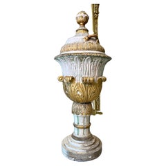
18thC Italian baptismal font
Located in Livorno, IT
Magnificent 18thC Italian baptismal font. Circular tank also lacquered in a soft color. Lid blue-lacquered inside and white-lacquered outside with beautiful gilt hand carvings. Main ...
Category

Mid-18th Century Italian Baroque Antique Engraved Collectibles and Curiosities

Materials

Gold Leaf

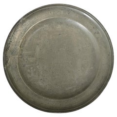
French 18th Century Pewter Plate of Saints Peter and Paul
Located in Baton Rouge, LA
An exceptional example of the European pewter tradition, this ceremonial charger plate from France dates to the year 1735 and depicts an exchange between the Saints Peter and Paul th...
Category

18th Century French Other Antique Engraved Collectibles and Curiosities

Materials

Pewter

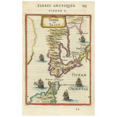
1685 Alain Manesson Mallet Map of Hokkaido (Lesso) in Northern Japan
Located in Langweer, NL
Title: 1685 Alain Manesson Mallet Map of Hokkaido, Iesso, and Company’s Land Description: This engraved seventeenth-century map, titled Terre de Iesso, was published in 1685 as pa...
Category

1680s Antique Engraved Collectibles and Curiosities

Materials

Paper

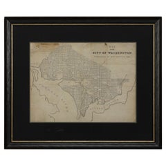
1840 Map of the City of Washington Published by William M. Morrison
Located in Colorado Springs, CO
This map, printed in 1840, is a detailed representation of Washington, D.C. in the mid-19th century. The map shows block numbers, wards, and government buildings as well as details o...
Category

1840s American Federal Antique Engraved Collectibles and Curiosities

Materials

Paper

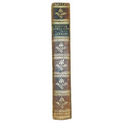
1st Edition of ‘Rural & Domestic Life of Germany’ by W Howitt -1842
Located in Dallas, TX
PRESENTING AN EXTREMELY RARE FIRST EDITION hardback copy of ‘The Rural and Domestic Life of Germany with Characteristic Sketches of its Cities and Scenery, Collected in a General To...
Category

Mid-19th Century English Country Antique Engraved Collectibles and Curiosities

Materials

Paper

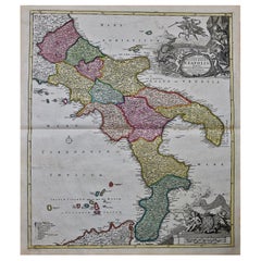
The Kingdom of Naples and Southern Italy: A Hand-Colored 18th Century Homann Map
Located in Alamo, CA
"Novissima & exactissimus Totius Regni Neapolis Tabula Presentis Belli Satui Accommo Data" is a hand colored map of southern Italy and the ancient Kingdom of Naples created by Johann...
Category

Early 18th Century German Antique Engraved Collectibles and Curiosities

Materials

Paper

Signed 1st Edition of 'Minding the Store' by Stanley Marcus
Located in Dallas, TX
PRESENTING A SIGNED FIRST EDITION of ‘Minding the Store’ A Memoir by Stanley Marcus. Published by Little, Brown (1974). First Edition Second Printing. Pages 383. Dust Cover in fai...
Category

Late 20th Century American Mid-Century Modern Engraved Collectibles and Curiosities

Materials

Paper

Austrian Art Nouveau Silver and Enamel Cane by Georg Adam Scheid
Located in London, GB
Austrian Art Nouveau silver and enamel cane by Georg Adam Scheid Austrian, 1872 Height 90cm, diameter 3cm This stunning Art Nouveau walking stick, created around 1900, is the work ...
Category

Late 19th Century Austrian Art Nouveau Antique Engraved Collectibles and Curiosities

Materials

Silver, Enamel

Western Wall Heritage Mezuzah – Hand-Carved Stone by Gideon Bustani
Located in New York, NY
This exquisite mezuzah is hand-carved from authentic Jerusalem stone, originally part of the Western Wall. These historic stones, uprooted due to structural shifts over 70 years ago, were later repurposed to cover marble sinks used...
Category

2010s Israeli Engraved Collectibles and Curiosities

Materials

Stone

Hand-Colored 18th Century Homann Map of the Danube, Italy, Greece, Croatia
Located in Alamo, CA
"Fluviorum in Europa principis Danubii" is a hand colored map of the region about the Danube river created by Johann Baptist Homann (1663-1724) in his 'Atlas Novus Terrarum', publish...
Category

Early 18th Century German Antique Engraved Collectibles and Curiosities

Materials

Paper

Gascogne and Guyenne Map - Hand-Colored 17th-Century Engraving by De Wit, c.1688
Located in Langweer, NL
Title: Gascogne and Guyenne Map - Hand-Colored 17th-Century Engraving by Frederik De Wit c. 1688 Description: This remarkable map, "Gouvernement de la Guyenne & Gascogne," captures ...
Category

1680s Antique Engraved Collectibles and Curiosities

Materials

Paper

Hand Colored 18th Century Homann Map of Austria Including Vienna and the Danube
Located in Alamo, CA
"Archiducatus Austriae inferioris" is a hand colored map of Austria created by Johann Baptist Homann (1663-1724) and published in Nuremberg, Germany in 1728 shortly after his death. ...
Category

Early 18th Century German Antique Engraved Collectibles and Curiosities

Materials

Paper

The Life Record of HW Graber Texas Ranger Dedicated First Edition
Located in Dallas, TX
Presenting a very rare first edition hardback copy of The Life Record of H.W. Grabber, A Terry Texas Ranger 1861-1865 Sixty-Two Years in Texas. Copyright ...
Category

Early 20th Century American American Classical Engraved Collectibles and Curiosities

Materials

Paper

Antique Western French Bulldog Club Best in Show Madam X Plaque & Artist Drawing
Located in Hamilton, Ontario
This grouping dates to approximately 1910 and is composed of an award plaque presented to "Madam X" by the Western French Bulldog Club for a Specialty Show and a pen and ink drawing ...
Category

Early 20th Century Unknown Edwardian Engraved Collectibles and Curiosities

Materials

Metal

English 1953 Elizabeth II Coronation Glass Goblet by Webb
Located in Chapel Hill, NC
1953 Elizabeth II Coronation Glass Goblet by Webb, England. Rose & Thistle engraving. Hand-blown. Signed: Webb, England. Drawn trumpet form. St. Edward's Crown & the symbols of Engla...
Category

1950s English Vintage Engraved Collectibles and Curiosities

Materials

Glass

"The Masterpieces of Engraving"
By Eugene Maxime Vallée
Located in Alessandria, Piemonte
O/7821 - interesting French book that I saved from ruin: they are usually dismembered to make prints to sell individually. This one is intact, with its 24 printed plates. Nice to ...
Category

Mid-19th Century French Other Antique Engraved Collectibles and Curiosities

Materials

Paper

Large and Impressive German Antique Finely Engraved Judaica Pewter Seder Plate
Located in London, GB
The fine German antique pewter plate depicts a family scene, as the group sits at the table during the Passover Seder. Around the rim of the plate...
Category

19th Century Antique Engraved Collectibles and Curiosities

Materials

Pewter

Sweden & Adjacent Portions of Scandinavia: A Hand-Colored 18th C. Map by Homann
Located in Alamo, CA
This hand-colored map of Sweden and adjacent portions of Scandinavia entitled "Regni Sueciae in Omnes suas Subjacentes Provincias accurate divisi Tabula Generalis" was created by Joh...
Category

1720s German Antique Engraved Collectibles and Curiosities

Materials

Paper

20th Century Italian Solid Silver Holy Water Stoup with Tap
Located in VALENZA, IT
Holy water stoup in 800 solid silver. Made entirely by hand, embossed and chiseled with leaves and pods motif. The lid is removable to allow water to ...
Category

1970s Italian Other Vintage Engraved Collectibles and Curiosities

Materials

Silver

18th Century Hand-Colored Homann Map of Germany, Including Frankfurt and Berlin
Located in Alamo, CA
An 18th century hand-colored map entitled "Tabula Marchionatus Brandenburgici et Ducatus Pomeraniae quae sunt Pars Septentrionalis Circuli Saxoniae Superioris" by Johann Baptist Homa...
Category

Early 18th Century German Antique Engraved Collectibles and Curiosities

Materials

Paper

Hand Colored 17th Century Visscher Map "Hollandiae" Southern Holland
Located in Alamo, CA
A hand colored 17th century map of the southern portions of Holland by Nicolaus (Nicolas) Visscher II entitled "Hollandiae pars Meridionalis, vulgo Zuyd-Holland", published in Amsterdam in 1678. The map shows the region between Breda, Heusden, Gornichem, Gouda, Dordrecht, and Willemstad. It includes a decorative cartouche in the lower left corner. The map is presented in an attractive maple colored wood frame with gold trim and a fabric mat. The Visscher family were one of the great cartographic families of the 17th century. Begun by Claes Jansz Visscher...
Category

Early 18th Century Dutch Antique Engraved Collectibles and Curiosities

Materials

Paper

French 19th Century 9k Gold Engraved Pocket Watch Key Fob Pendant and Rubies
Located in Sofia, BG
French golden engraved pocket watch key that would look great even just as a pendant on a proper chain. It has delicate engravings on the top and three surrounded small ruby stones t...
Category

Late 19th Century French Antique Engraved Collectibles and Curiosities

Materials

Gold

Historical Map of the Duchy of Lauenburg by Johann Baptist Homann - Circa 1720
Located in Langweer, NL
Historical Map of the Duchy of Lauenburg by Johann Baptist Homann - Circa 1720 This splendid historical map titled Ducatus Lauemburgicus is a highly detailed and beautifully engra...
Category

1720s Antique Engraved Collectibles and Curiosities

Materials

Paper

Venetian Trade Routes in the Levant – Antique Map by Pieter van der Aa, ca.1720
Located in Langweer, NL
Venetian Trade Routes in the Levant – Antique Map by Pieter van der Aa, Early 18th Century This finely engraved map, published by Pieter van der Aa in Leiden, provides a detailed d...
Category

1720s Antique Engraved Collectibles and Curiosities

Materials

Paper

Early 20th Century Argentinian Silver and Gold Torah Crown
Located in New York, NY
Silver and gold Torah crown, Buenos Aires, Argentina, 1925. On silver base decorated with a small gold Stars of David. The lower ribs decorated with applie...
Category

1920s Argentine Vintage Engraved Collectibles and Curiosities

Materials

Silver, Gold

1773 Map of Persia, Gujarat & Malabar Coasts – Arabia to India, Hand-Colored
Located in Langweer, NL
1773 Bellin map of Persia, Gujarat and Malabar coasts with Arabia and Maldives Description: This finely engraved and delicately hand-colored 18th-century map titled Kaart van de Kusten van Persië, Guzaratte en Malabar was produced by the eminent French cartographer Jacques-Nicolas Bellin and engraved by Jakob van der Schley. It was published in 1773 in Amsterdam by E. van Harrevelt and D. Changuion, as part of a Dutch edition of Bellin’s maritime atlas focused on the East Indies and the Indian Ocean. The map presents the coastline bordering the Arabian Sea, extending from the Persian Gulf and parts of the Arabian Peninsula to the shores of Gujarat and the Malabar Coast in southwestern India. It provides a detailed representation of the coastlines of Persia (modern-day Iran), the western coast of India, and a portion of southern Arabia including the Oman Peninsula. Coastal towns, rivers, ports, and geographical landmarks are clearly labeled, including prominent trading centers like Surat, Goa, Calicut, Cochin, and Cape Comorin (now Kanyakumari). Additionally, the map shows the Laccadive Islands (Laka Dives) and the Maldives (Maldivische Eilanden), with attention to navigational details such as shoals, sandbanks, and anchor points. A large compass rose and clear latitude and longitude markings enhance its utility as a navigational aid. A highly decorative title cartouche at lower left features maritime iconography such as sea creatures, a fountain, and shells. An inset legend beneath the map provides explanations in Dutch for the symbols used to indicate bays, capes, ports, forts, islands, and towns. This is a copperplate engraving printed on laid paper with full original hand coloring. It retains its original fold lines as issued. The condition is generally good, with minor age toning and a few light spots in the margins. No repairs or restoration are visible. The paper is strong, and the impression remains crisp and clear. This historical map is a significant and attractive example of 18th-century European cartography, especially valued for its depiction of maritime trade regions and coastal geography during the age of exploration and colonial expansion. To frame this 1773 Bellin map attractively and safely: - Use acid-free matting in a neutral tone like cream or antique white - Consider double matting with a subtle inner color that complements the map - Choose a simple wooden frame in walnut, cherry, or aged oak for a classic look - Use UV-protective glass or acrylic to prevent fading - For a full display, consider float mounting to show the edges and fold lines - Allow 2 to 3 inch mat margins to balance the composition and enhance presentation Keywords: Bellin map 1773, van der Schley, Persia coast map, Gujarat map, Malabar map...
Category

1780s Antique Engraved Collectibles and Curiosities

Materials

Paper

Sphere table cigarette lighter Red enamel Salimbeni
Located in Firenze, FI
Sphere table cigarette lighter in 925/1000 gold-plated sterling silver and translucent fire enamel on guilloché, in a modern contemporary style. Piezoelectric mechanism. Dimensions d...
Category

1970s Italian Modern Vintage Engraved Collectibles and Curiosities

Materials

Gold Plate, Sterling Silver, Enamel

Ilya Schor Silver Bridal Dowry Bracelets – "Wild Bird of the Queen of Sheba"
Located in New York, NY
This exquisite pair of handcrafted silver bracelets, created by artist and master engraver Ilya Schor in New York in 1950, were designed as part of a bridal dowry. Featuring intricat...
Category

Mid-20th Century American Engraved Collectibles and Curiosities

Materials

Silver

Haida Sterling Silver Cuff Bracelet by Ron A. Sebastian 'Gitksan People', Canada
By Ron A. Sebastian
Located in Ottawa, Ontario
An impressively large handcrafted sterling silver Haida cuff bracelet / bangle, decorated overall with traditional totemic Haida motifs and centred by a striking abalone roundel. The interior bearing the artists signature & dated 1979, together with a dedication to Dr. George F. McDonald, noted Canadian anthropologist & former Executive Director of the Canadian Museum of Man. Dimensions: 3” high x 3” diameter. Weight, 96 grams. Ron A. Sebastian (1945- ) is a highly accomplished Northwest British Columbia native artist, who is both a member of the Gitksan and Wet'suwet'en Peoples. Ron studied carving & design at the Gitanmaax School of Northwest Coast Indian...
Category

Late 20th Century Canadian Other Engraved Collectibles and Curiosities

Materials

Sterling Silver

Antique Gilt Copper & Enamel Ladies Compac with Hand Painted Portrait
Located in Hamilton, Ontario
This antique miniature ladies compac is unsigned with respect to the maker, but originated from Italy and dates to approximately 1880 and done in a Renaissance Revival style. The box...
Category

Late 19th Century Italian Renaissance Revival Antique Engraved Collectibles and Curiosities

Materials

Copper

1837 Mitchell's "Tourist's Pocket Map of the State of Virginia" by J.H. Young
Located in Colorado Springs, CO
This is J. H. Young's pocket map of the Virginia, which shows county development current to 1835. The map was engraved by E. Yeager and F. Dankworth and published by S. A. Mitchell. ...
Category

1830s American Antique Engraved Collectibles and Curiosities

Materials

Paper

1842 Wall Map of the United States by J. H. Young, Published by S. A. Mitchell
Located in Colorado Springs, CO
Presented is an 1842 hanging “Map of the United States,” engraved by J. H. Young and published by Samuel Augustus Mitchell, Philadelphia. This is a beautiful example of the rare 1842...
Category

1840s American Antique Engraved Collectibles and Curiosities

Materials

Paper

Europe Divided into Principal States by Jean Denis Janvier, Paris, 1782
Located in Langweer, NL
This is a historical map of Europe titled "L'Europe divisee en ses Principaux Etats," created by Jean Denis Janvier in 1782. This beautiful map depicts the political boundaries and...
Category

1780s Antique Engraved Collectibles and Curiosities

Materials

Paper

1856 U.S. Coast Survey Map of Chesapeake Bay and Delaware Bay
Located in Colorado Springs, CO
Presented is U.S. Coast Survey nautical chart or maritime map of Chesapeake Bay and Delaware Bay from 1856. The map depicts the region from Susquehanna, Maryland to the northern Outer Banks in North Carolina. It also shows from Richmond and Petersburg, Virginia to the Atlantic Ocean. The map is highly detailed with many cities and towns labeled throughout. Rivers, inlets, and bays are also labeled. Various charts illustrating more specific parts of the region are marked on the map using dotted lines. The lines form boxes, and the corresponding chart number and publication date are given. Extensive triangulation surveys were conducted the length of Chesapeake Bay and are illustrated here. Hampton Roads, Virginia is labeled, along with the James, York, and Rappahannock Rivers, which were all extensively surveyed. The chart was published under the supervision of A. D. Bache, one of the most influential and prolific figures in the early history of the U.S. Coast Survey, for the 1856 Report of the Superintendent of the U.S. Coast Survey. Alexander Dallas Bache (1806-1867) was an American physicist, scientist, and surveyor. Bache served as the Superintendent of the U.S. Coast Survey from 1843 to 1865. Born in Philadelphia, Bache toured Europe and composed an important treatise on European Education. He also served as president of Philadelphia's Central High School and was a professor of natural history and chemistry at the University of Pennsylvania. Upon the death of Ferdinand Rudolph Hassler, Bache was appointed Superintendent of the United States Coast Survey. The Office of the Coast Survey, founded in 1807 by President Thomas Jefferson and Secretary of Commerce Albert Gallatin...
Category

1850s American Antique Engraved Collectibles and Curiosities

Materials

Paper

Antique 1830 Map of Leinster, Ireland with Dublin, Kilkenny, Wexford and Kildare
Located in Langweer, NL
Title: Antique 1830 Map of Leinster, Ireland with Dublin, Kilkenny, Wexford, and Kildare Description: This 1830 German-language map, titled Britisches Reich – C. Kon: Ireland, f...
Category

1830s Antique Engraved Collectibles and Curiosities

Materials

Paper

Rare Hand-Colored Map of Franche-Comté and Burgundy by Frederik De Wit c. 1688
Located in Langweer, NL
Title: Rare Hand-Colored Map of Franche-Comté and Burgundy by Frederik De Wit c. 1688 Description: This stunning 17th-century map, titled "Comitatus Burgundiae vulgo La Franche Comt...
Category

1680s Antique Engraved Collectibles and Curiosities

Materials

Paper

Antique French Crystal, Vermeil and Gemstone Cane
Located in London, GB
Antique French crystal, vermeil and gemstone cane French, c. 1890 Height 89cm, diameter 2.5cm Masterfully crafted in late 19th century France, this exquisite walking stick is ado...
Category

Late 19th Century French Belle Époque Antique Engraved Collectibles and Curiosities

Materials

Crystal, Multi-gemstone, Vermeil

Friesland, Groningen, Drenthe, Overijssel – Antique Map by Seb. Münster, 1574
Located in Langweer, NL
Friesland, Groningen, Drenthe, Overijssel – Antique Map by Sebastian Münster, 1574 This rare and finely colored woodcut map of Northern Netherlands depicts the provinces of Friesl...
Category

16th Century Antique Engraved Collectibles and Curiosities

Materials

Paper

18th Century Hand Colored Map of Spain and Portugal by Visscher
Located in Alamo, CA
This is an early 18th century map of Spain and Portugal, with attractive original hand-coloring, entitled "Hispaniae et Portugalliae Regna per Nicolaum Visscher cum Privilegio Ordinu...
Category

Early 18th Century Dutch Antique Engraved Collectibles and Curiosities

Materials

Paper

A Gold Cantor Brooch from the Independent Order B'nai Abraham, 1904
Located in New York, NY
A Gold Cantor Brooch from the Independent Order B'nai Abraham dating back to 1904 is a piece of historical and cultural significance. Independent Order B'nai Abraham (IOBA) was fou...
Category

Early 1900s American Antique Engraved Collectibles and Curiosities

Materials

Gold

Map of Constantinople, Bosphorus, the Coasts of Greece and the Archipelago, 1785
Located in Langweer, NL
This is a large 1785 map titled "Carte de la Ville de Constantinople et du Bosphore de Thrace", which includes detailed maps of Constantinople (modern-day Is...
Category

1780s Antique Engraved Collectibles and Curiosities

Materials

Paper

Authentic Old Map of Sumatra, Malaysia and Singapore, 1745
Located in Langweer, NL
Title: "Kaartje van't Eiland Sumatra en de Maleidse Kust gelegen na de stelling van de G. de L'Isle" Published by Jacob Keizer and by Jan de Lat Creator: Keizer, Jacob, active 1706...
Category

1740s Antique Engraved Collectibles and Curiosities

Materials

Paper

1732 Henri Chatelain Map of the Holy Land Divided Among the Tribes of Israel
Located in Langweer, NL
Title: 1732 Henri Chatelain Map of the Holy Land Divided Among the Tribes of Israel This exquisite 18th-century map by Henri Chatelain, published in 1732, offers a detailed depict...
Category

1710s Antique Engraved Collectibles and Curiosities

Materials

Paper

1718 Holy Land Map - Twelve Tribes, Six Provinces, Hand-Colored, Antique Map
Located in Langweer, NL
Title: Terra Sancta in XII olim Tribus nunc VI Provincias Dispertita Cartographer: Christoph Weigel the Elder (1654–1725) Publisher: Johann Ernst Adelbulner Publication Locatio...
Category

1710s Antique Engraved Collectibles and Curiosities

Materials

Paper

Shepherd's View of & Around Regent's Park : 37 Engravings in Fine Binding
Located in Ilkley, GB
A selection of 37 window-mounted, hand coloured views around Regent’s Park in a super-luxurious bespoke Sotheran’s binding. Chunky square format (25x25cm) bound in crushed red moroc...
Category

19th Century British Regency Antique Engraved Collectibles and Curiosities

Materials

Paper

Map of Choromandel & Malabar, Incl Kerala, Tamil Nadu & Part of Sri Lanka, 1726
Located in Langweer, NL
Antique map titled 'Nieuwe kaart van Choromandel ende Malabar.' Original antique map of Southern India documenting the VOC's areas of influence. Included is Kerala, Tamil Nadu...
Category

1720s Antique Engraved Collectibles and Curiosities

Materials

Paper

Engraved 'Cape of Good Hope' Colonial Commemorative Glass, 18th Century
Located in Amsterdam, NL
A commemorating glass with an engraving of a farmer ploughing, an East Indiaman and a text reading: Het Lan’s Wel Varen An De Caap (the country’s prosperity at the Cape of Good Hope...
Category

18th Century South African Antique Engraved Collectibles and Curiosities

Materials

Glass

Antique German Military Cut Crystal & Continental Silver Presentation Claret Jug
Located in Hamilton, Ontario
This antique German cut crystal and .800 silver lidded pitcher was made by a Julius Merz in circa 1900 in the period Edwardian style. The collar and...
Category

Early 20th Century German Edwardian Engraved Collectibles and Curiosities

Materials

Crystal, Silver

Antique English Dart Game Trophy Award Shield Oak Plaque Silver Plate c1909
Located in Shreveport, LA
Antique English Dart Game Trophy Award Shield Oak Plaque Silver Plate c1909. Direct from England, just arrived in our most recent container, we have several ...
Category

Early 1900s British Sporting Art Antique Engraved Collectibles and Curiosities

Materials

Silver Plate

Johannes Brahms Composer Historic Hand Autographed in Ink Engraving / Etching
By Johannes Brahm
Located in Westport, CT
Johannes Brahms autographed hand signed in ink engraving etching 1885 with original cardboard to back of frame. Johannes Brahms German composer and pianist, 1833-1897 "In his lifetime, Brahms's popularity and influence were considerable. He is sometimes grouped with Johann Sebastian Bach and Ludwig van Beethoven as one of the "Three Bs", a comment originally made by the nineteenth-century conductor Hans von...
Category

Late 19th Century Austrian Romantic Antique Engraved Collectibles and Curiosities

Materials

Glass, Wood, Paper

Aristitde Maillol Illustrated: Daphnis & Chloe
By Aristide Maillol 2
Located in Middletown, NY
According to Eleanor Garvey "The Artist and the Book" (p. 122) this work is "perhaps the most harmonious of Maillol's illustrated books." Aristide MAILLOL, illus.; LONGUS author Daphnis and Chloe; A Most Sweet, and Pleasant Pastoral Romance for Young Ladies, translated out of the Greek of Longus by Geo. Thornley. London: A. Zwemmer [printed in Paris by Philippe Gonin], 1937. Limited Edition. 8vo, 7 3/4 x 5 1/2 in. (200 x 132 mm); pp. vi, 211,colophon,12; Copy 21 of 250 numbered copies on hand-made Maillol paper and SIGNED BY THE ARTIST on the colophon, with 52 original woodcuts, and 4 woodcut initials, printed in bistre; leading and bottom edges deckled. Full vellum with laced-in thongs, gilt lettering on spine, faint; pencil notations and tipped in label from earlier booksellers on inside front cover, edges stained on first 2 and last 2 blanks. EXTRA SUITE of 45 WOODCUTS in a separate vellum portfolio, printed in black. Fine copy in simple cardboard slipcase. Colophon: "Aristide Maillol engraved with his own hand the wood-cuts which illustrate this book, The text is that of Thronley's translation of 1657, revised and augmented. Philippe Gonin of Paris undertook the achievement of this work, and printed it on his hand-press, for A. Zwemmer, London. Paris December 7th, 1937", followed by MAILLOL'S SIGNATURE IN PENCIL. Garvey 174; Garvey Wick 22; BNF32393010 Condition: FINE An ancient Greek novel written during the Roman Empire, the only known work of the 2nd century AD Greek novelist and romance writer Longus, translated by George Thornley...
Category

1930s British Vintage Engraved Collectibles and Curiosities

Materials

Paper, Parchment Paper

14-Karat Yellow Gold with Agate & Claw Set Citrine Quartz Brooch or Pendant
Located in Hamilton, Ontario
Presumed to be a Victorian brooch with a contemporary assay mark, this artisan made 14- karat yellow gold disc shaped pendant pin is heavily engraved and combined with an agate surro...
Category

Late 19th Century English Victorian Antique Engraved Collectibles and Curiosities

Materials

Gold

Very Rare Wind Vane Dial in the Manner of Whitehurst
Located in Lincolnshire, GB
A George III period carved mahogany wind vane dial. The silvered engraved dial with all the points of a compass housed in the finely carved mahogany frame, ...
Category

Late 18th Century English Antique Engraved Collectibles and Curiosities

Materials

Glass, Mahogany

Antique Map of the County of Burgundy by Johann Baptist Homann circa 1710
Located in Langweer, NL
Antique Map of the County of Burgundy by Johann Baptist Homann circa 1710 Hand-Colored This finely detailed antique map titled Comitatus Burgundia depicts the historic region of t...
Category

1720s Antique Engraved Collectibles and Curiosities

Materials

Paper

Fine William IV Sterling Silver Vinaigrette by Joseph Willmore, Birmingham, 1835
Located in Ottawa, Ontario
The lid and underside showing a fine engine-turned surface, the hinged lid decorated with a foliate cast border opening to a richly gilded interior housing an exceptionally fine hand-pierced & foliate engraved hinged grille. The interior bearing impressed Birmingham hallmark, date mark for 1835 & makers marks for Joseph Willmore...
Category

Mid-19th Century English William IV Antique Engraved Collectibles and Curiosities

Materials

Sterling Silver

Large and Very Rare Silver-Inlaid Antique Judaica Tray
Located in London, GB
A large and very rare silver-inlaid antique Judaica tray Jerusalem, c.1900 Height 2.5cm, diameter 62cm This large and remarkable work is a copper and silver-inlaid antique Jewish tray, featuring meticulous and exceptional metalwork, and was made in Jerusalem around the turn of the twentieth century. It features a twelve-fold repeating pictorial decoration, which is set between two circles, that of the central ring in which a large menorah...
Category

Early 1900s Israeli Modern Antique Engraved Collectibles and Curiosities

Materials

Silver, Brass, Copper

Historical Map of Northern Europe and Russia - Engraved for I. Harrison, 1788
Located in Langweer, NL
Historical Map of Northern Europe and Russia - Engraved for I. Harrison, 1788 This impressive historical map titled A New Map of Europe Containing Denmark, Norway, Sweden and Russ...
Category

1780s Antique Engraved Collectibles and Curiosities

Materials

Paper

Genuine Antique Engraved Map of Helvetia or Switzerland, 1729
Located in Langweer, NL
Decorative early 18th century engraved map of Switzerland. Title: Helvetia Conterminarumq terra rum antiqua. Translated from Latin: Switzerland is an ancient land Description: Switzerland, antique copperplate engraved map with hand coloring and a decorative title cartouche. Two figures greatly enhances visual appeal. Author: Phillip Cluver, or Philip Cluverius, Philipp Clüver, Latinized as Philippus Cluverius studied law in Leiden and settled over there in 1615. We only sell Guaranteed Absolutely Original authentic Maps and Prints. A Certificate of Authenticity ( COA ) will be supplied on request. We ship our antique maps and prints...
Category

1720s Antique Engraved Collectibles and Curiosities

Materials

Paper

Read More

Medal-Worthy Memorabilia from Epic Past Olympic Games

Get into the games! These items celebrate the events, athletes, host countries and sporting spirit.

Ahoy! You’ve Never Seen a Collection of Sailor Art and Kitsch Quite Like This

French trendsetter and serial collector Daniel Rozensztroch tells us about his obsession with objects related to seafaring men.

Pamela Shamshiri Shares the Secrets behind Her First-Ever Book and Its Effortlessly Cool Interiors

The sought-after designer worked with the team at Hoffman Creative to produce a monograph that beautifully showcases some of Studio Shamshiri's most inspiring projects.

Moroccan Artworks and Objects Take Center Stage in an Extraordinary Villa in Tangier

Italian writer and collector Umberto Pasti opens the doors to his remarkable cave of wonders in North Africa.

Montecito Has Drawn Royalty and Celebrities, and These Homes Are Proof of Its Allure

Hollywood A-listers, ex-pat aristocrats and art collectors and style setters of all stripes appreciate the allure of the coastal California hamlet — much on our minds after recent winter floods.

Whaam! Blam! Pow! — a New Book on Pop Art Packs a Punch

Publishing house Assouline and writer Julie Belcove have teamed up to trace the history of the genre, from Roy Lichtenstein, Andy Warhol and Yayoi Kusama to Mickalene Thomas and Jeff Koons.

The Sparkling Legacy of Tiffany & Co. Explained, One Jewel at a Time

A gorgeous new book celebrates — and memorializes — the iconic jeweler’s rich heritage.

What Makes a Gem-Encrusted Chess Set Worth $4 Million?

The world’s most opulent chess set, weighing in at 513 carats, is literally fit for a king and queen.
Recently Viewed

View All